This report contains an electronic supplement, consisting of eight parts: 1) Cross sections and estimated displacements across the Brigham City segment (BCS); 2) Table of radiocarbon and luminescence ages used in this report; 3) Evaluation of Box Elder delta earthquake chronology; 4) Code of OxCal models shown in Figure 2; 5) Reinterpretation of Bowden Canyon trench log; 6) Sources of surface offset data for Figures 4b and 8; 7) Descriptions of Calls Fort gravel pit fault exposures; and 8) List of references cited in the electronic supplement.
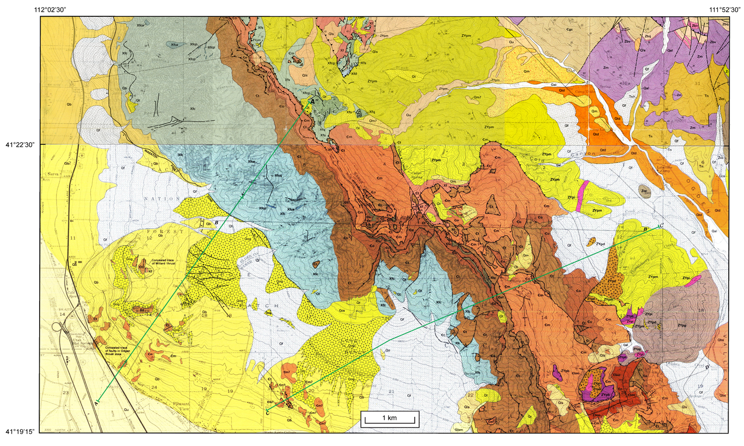
FigureS1a.jpg. Location map of cross section A-A'-A" across the southern BCS and cross section C-C' across the northern Weber segment; geologic base maps are Crittenden and Sorensen (North Ogden, Ogden, and Plain City quadrangles, 1985a) to south and Mantua and Willard quadrangles (1985b) to north.
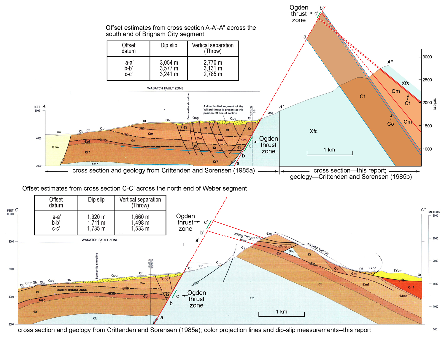
FigureS1b.jpg. Cross section A-A'-A" across the southern BCS and cross section C-C' across the northern Weber segment at Pleasant View salient; from Crittenden and Sorensen (1985a). Section A'-A" interpreted from geologic contacts and bedding attitudes simplified from Crittenden and Sorensen (1985a; 1985b).
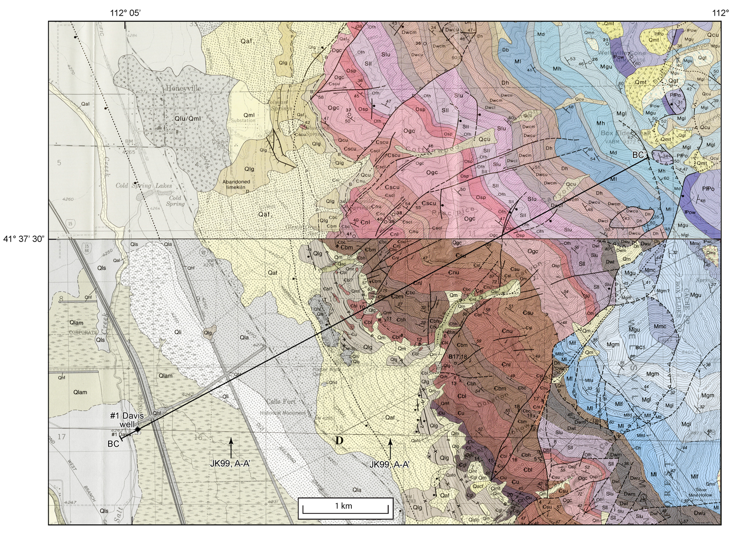
FigureS1c.jpg. Location map of cross section BC-BC' across the northern BCS; geologic base maps are Honeyville quadrangle to north (Oviatt, 1986) and Brigham City quadrangle to south (Jensen and King, 1999); both maps reprinted with permission of Utah Geological Survey. JK99, A-A' marks part of the line of cross section A-A' of Jensen and King (1999).
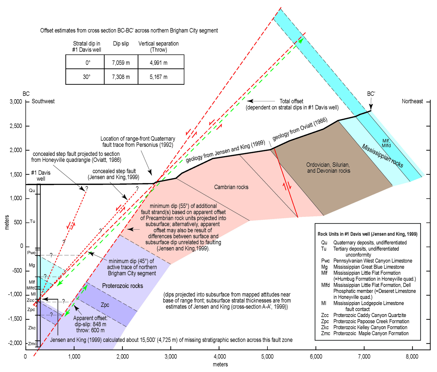
FigureS1d.jpg. Cross section BC-BC' across the northern BCS, from geothermal test well #1 Davis on west, to crest of Wellsville Mountains. Geologic contacts and bedding attitudes in Wellsville Mountains are simplified from Oviatt (1986) and Jensen and King (1999). Subsurface contacts are modified from cross section A-A' and discussion of relations in #1 Davis test well of Jensen and King (1999; redrawn with permission of Utah Geological Survey).
Table S1. Descriptions of radiocarbon and luminescence ages used in this report.
Code for OxCal models shown in Figure 2, using OxCal v4.1.7 (Bronk Ramsey, 1995, 2001, 2008), and the IntCal09 calibration curve of Reimer et al. (2009).
FigureS2a.jpg. Original trench log of Personius (1991a, Fig. 6); reprinted with permission of Utah Geological Survey.
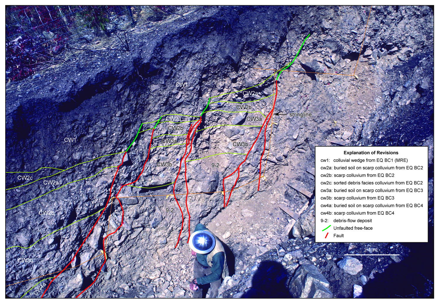
FigureS2b.jpg. Reinterpretation of part of Bowden Canyon trench wall (Personius, 1991a); base is oblique photo circa October, 1986 by S.F. Personius.
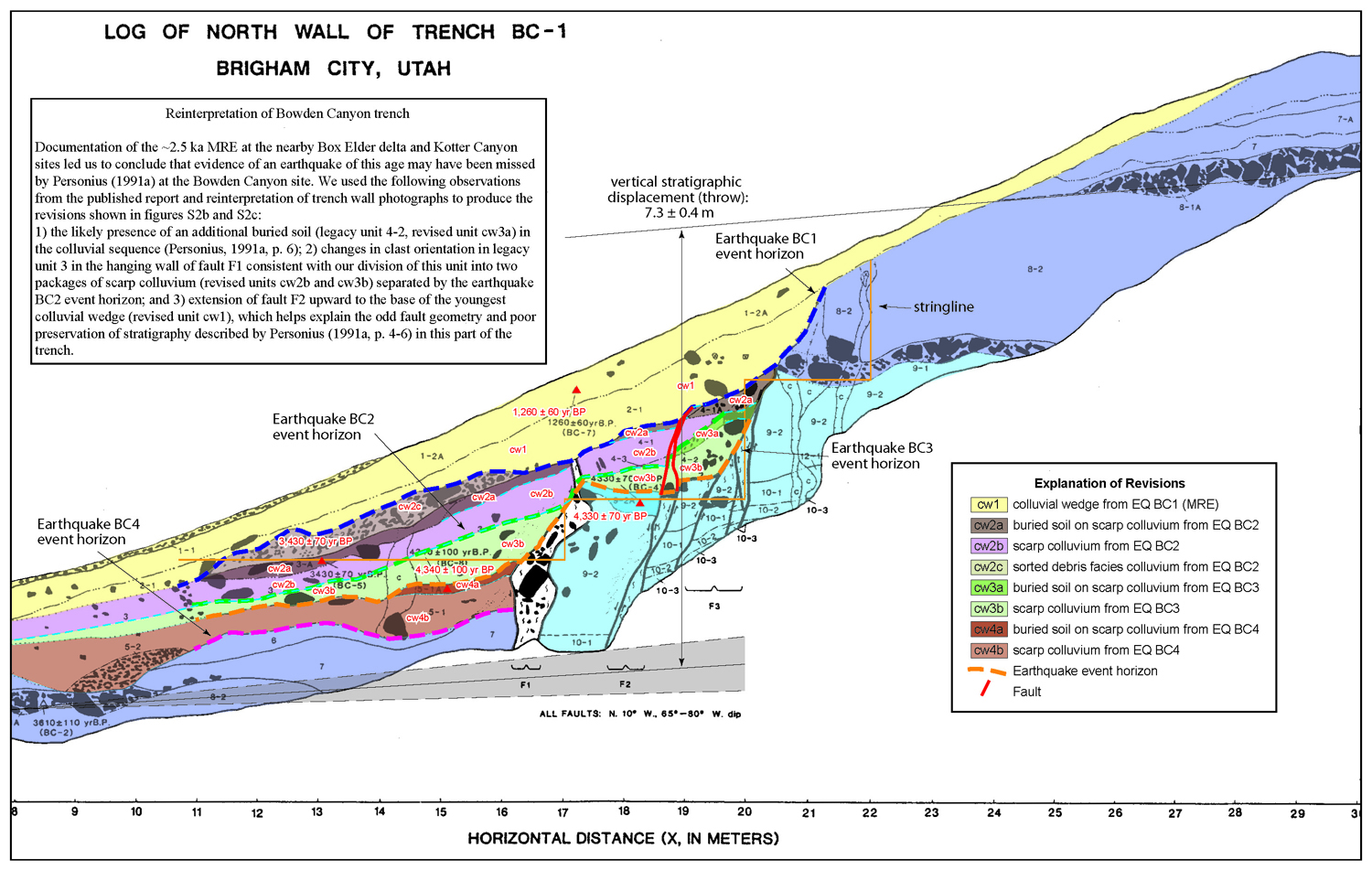
FigureS2c.jpg. Reinterpreted log of Personius (1991a), based on field notes and analysis of trench wall photographs (Fig. S2b). See text for discussion.
Table S2. Data and sources of surface offset measurements shown in Figures 4b and 8.
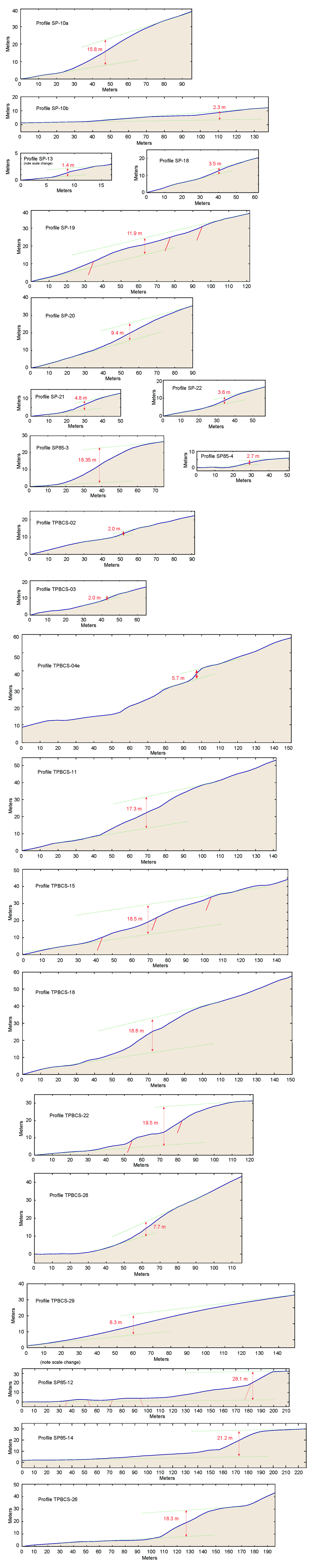
FigureS3.jpg. Plots of unpublished topographic profiles across the Brigham City segment used to determine surface offset measurements shown in Figures 4b and 8. Profiles with numbers beginning with "SP" were measured in the field with collapsible stadia rod and Abney level; profiles with numbers beginning with "TPBCS" were measured with Global Mapper GIS software from 5-m DEM acquired from the Utah Automated Geographic Reference Center (AGRC).
Plocations.kml. Keyhole Markup Language (KML) file of locations of topographic profiles shown in Figure S3. (KML files, developed for use with Google Earth, enable geographic annotation and visualization within internet-based, two- or three-dimensional maps.)
Description of Calls Fort gravel pit fault exposures.
FigureS4.jpg. (a) Location map of Calls Fort gravel pit exposures (see Figure 1 for location); base map from Personius (1990). Map units: af1—upper Holocene fan alluvium; aft—middle Holocene to uppermost Pleistocene fan alluvium; cd1—upper Holocene debris flows; chs—Holocene to upper Pleistocene hillslope colluvium; lbpg—upper Pleistocene (Bonneville) sand and gravel; lpg—uppermost Pleistocene sand and gravel related to Provo shoreline; MCr—Mississippian to Cambrian bedrock; uppercase "P" marks Provo shoreline. (b) View looking north of broad fault zone in late Pleistocene gravels of Bonneville lake cycle. White line marks contact between transgressive-phase gravel (Btg; 24-30 ka) unconformably overlain by silty sandy gravel reworked during regression of the lake from Provo shoreline (Prg; <15 ka). Total apparent throw across the fault zone is about 2.2 m. (c) Close-up of main fault zone (see Fig. S4b for location). Three subaerial deposits of scarp colluvium (Cw1, Cw2, Cw3) overlie the recessional gravels, indicating at least three surface ruptures have occurred at the site since the lake regressed below this elevation (~1,356 m) <15 ka. (K—burrowed sediment). (d) Offset of remnants of carbonate-cemented lacustrine gravel (Blg) deposited on Paleozoic bedrock, overlain by an undifferentiated subaerial deposit of scarp colluvium. Exposed faults form a separate trace of the fault zone about 100 m upslope from the fault zone shown in Figures S4b and S4c. Total throw is about 2.0 m, but outcrop is likely eroded so we could not determine how many surface ruptures were recorded in this exposure.
Benson, L. V., S. P. Lund, J. P. Smoot, D. E. Rhode, R. J. Spencer, K. L. Verosub, L. A. Louderback, C. A. Johnson, R. O. Rye, and R. M. Negrini (2011). The rise and fall of Lake Bonneville between 45 and 10.5 ka, Quat. Internat. 235, 57-69.
Bronk Ramsey, C. (1995). Radiocarbon calibration and analysis of stratigraphy–the OxCal program, Radiocarbon, 37, no. 2, 425-430.
Bronk Ramsey, C. (2001). Development of the radiocarbon program OxCal, Radiocarbon 43, no. 2a, 355-363.
Bronk Ramsey, C. (2008). Depositional models for chronological records, Quat. Sci. Rev. 27, no. 1-2, 42-60.
Bucknam, R. C., and R. E. Anderson (1979). Estimation of fault-scarp ages from a scarp-height-slope-angle relationship, Geology 7, 11–14.
Crittenden, M. D. Jr., and M. L. Sorensen (1985a). Geologic map of the North Ogden quadrangle and part of the Ogden and Plain City quadrangles, Box Elder and Weber Counties, Utah, U.S. Geol. Surv. Misc. Inv. Series Map I-1606, scale 1:24,000.
Crittenden, M. D. Jr., and M. L. Sorensen (1985b). Geologic map of the Mantua quadrangle and part of the Willard quadrangle, Box Elder, Weber, and Cache Counties, Utah, U.S. Geol. Surv. Misc. Inv. Series Map I-1605, scale 1:24,000.
DuRoss, C. B., S. F. Personius, A. J. Crone, G. N. McDonald, and R. W. Briggs (2012). Late Holocene earthquake history of the Brigham City segment of the Wasatch fault zone at the Hansen Canyon, Kotter Canyon, and Pearsons Canyon trench sites, Box Elder County, Utah, in Paleoseismology of Utah, Vol. 22, W. R. Lund (Editor), Utah Geol. Surv Spec. Stud. 142, 62.
DuRoss, C. B., S. F. Personius, A. J. Crone, G. N. McDonald, and D. J. Lidke (2009). Paleoseismic investigation of the northern Weber segment of the Wasatch fault zone at the Rice Creek trench site, North Ogden, Utah, in Paleoseismology of Utah, Vol. 18, W. R. Lund (Editor), Utah Geol. Surv Spec. Stud. 130, 37.
Godsey, H. S., D. R. Currey, and M. A. Chan (2005). New evidence for an extended occupation of the Provo shoreline and implications for regional climate change, Pleistocene Lake Bonneville, Utah, USA, Quat. Res. 63, no. 2, 212-223.
Godsey, H. S., C. G. Oviatt, D. M. Miller, and M. A. Chan (2011). Stratigraphy and chronology of offshore to nearshore deposits associated with the Provo shoreline, Pleistocene Lake Bonneville, Utah, Palaeogeogr. Palaeoclimatol. Palaeoecol. 310, 442-450.
Janecke, S. U. and R. Q. Oaks, Jr. (2011). New insights into the outlet conditions of late Pleistocene Lake Bonneville, southeastern Idaho, USA, Geosphere 7, 1369-1391.
Jensen, M. E., and J. K. King (1999). Geologic map of the Brigham City 7.5-minute quadrangle, Box Elder and Cache Counties, Utah, Utah Geol. Surv. Map 173, 46, scale 1:24,000.
McCalpin, J. P. (1996). Paleoseismology, Academic Press, New York, 588.
McCalpin, J. P., and S. L. Forman, (2002). Post-Provo earthquake chronology of the Brigham City segment, Wasatch fault zone, Utah, in Paleoseismology of Utah, Vol. 13, W. R. Lund (Editor), Utah Geol. Surv Misc. Pub. 02-9, 46.
McCalpin, J. P., and S. P. Nishenko (1996). Holocene paleoseismicity, temporal clustering, and probabilities of future large (M>7) earthquakes on the Wasatch fault zone, J. Geophys. Res. 101, no. B3, 6233-6253.
Nelson, A. R., M. Lowe, S. Personius, L. A. Bradley, S. L. Forman, R. Klauk, and J. Garr (2006). Holocene earthquake history of the northern Weber segment of the Wasatch fault zone, Utah, in Paleoseismology of Utah, Vol. 13, W. R. Lund (Editor), Utah Geol. Surv. Misc. Pub. 05-8, 39.
Nelson, A. R., and S. F. Personius (1993). Surficial geologic map of the Weber segment, Wasatch fault zone, Weber and Davis Counties, Utah, U.S. Geol. Surv. Misc. Inv. Series Map I-2199, 22, scale 1:50,000.
Oviatt, C. G. (1986). Geologic map of the Honeyville quadrangle, Box Elder and Cache Counties, Utah, Utah Geol. Surv. Map 88, scale 1:24,000.
Personius, S. F. (1988). A brief summary of the surficial geology along the Brigham City segment of the Wasatch fault zone, Utah, in In the footsteps of G.K. Gilbert–Lake Bonneville and neotectonics of the eastern Basin and Range Province, Guidebook for Field Trip Twelve, M. N. Machette (Editor), Utah Geol. Surv. Misc. Pub. 88-1, 27-32.
Personius, S. F. (1990). Surficial geologic map of the Brigham City segment and adjacent parts of the Weber and Collinston segments, Wasatch fault zone, Box Elder and Weber Counties, Utah, U.S. Geol. Surv. Misc. Inv. Series Map I-1979, scale 1:50,000.
Personius, S. F. (1991a). Paleoseismic analysis of the Wasatch fault zone at the Brigham City trench site, Brigham City, Utah, in Paleoseismology of Utah, Vol. 2, W. R. Lund (Editor), Utah Geol. and Mineral Surv. Spec. Stud. 76, 1-18.
Personius, S. F. (1991b). Paleoseismic analysis of the Wasatch fault zone at the Pole Patch trench site, Pleasant View, Utah, in Paleoseismology of Utah, Vol. 2, W. R. Lund (Editor), Utah Geol. and Mineral Surv. Spec. Stud. 76, 19-39.
Reimer, P. J., M. G. L. Baillie, E. Bard, A. Bayliss, J.W. Beck, P. G. Blackwell, C. Bronk Ramsey, C. E. Buck, G. S. Burr, R. L. Edwards, M. Friedrich, P. M. Grootes, T. P. Guilderson, I. Hajdas, T. J. Heaton, A. G. Hogg, K. A. Hughen, K. F. Kaiser, B. Kromer, F. G. McCormac, S. W. Manning, R. W. Reimer, D. A. Richards, J. R. Southon, S. Talamo, C. S. M. Turney, J. van der Plicht, and C. E. Weyhenmeyer (2009). IntCal09 and Marine09 radiocarbon age calibration curves, 0–50,000 years cal BP, Radiocarbon 51, no. 4, 1111–1150.
[ Back ]