The tables below summarize the information on the data used in this study [Bilham et al. 2005; Gahalaut et al. 2006; Meltzner et al. 2006; Subarya et al. 2006; Vigny et al. 2005]. They consist of campaign GPS data (Tables 1, 2) and data from continuous GPS stations (Table 3). Cumulated postseismic displacements over 5 days [Vigny et al. 2005] and over 30 days are in tables 4 and 5. Vertical displacements are reported for coral measurements from Simeulue island (Table 6), estimates from eyewitness accounts (Table 7), estimation of the position of the pivot-line (Table 8). The predicted displacements of the models discussed in the main text are compared to the vertical observations in figure 1.
Table 1. Campaign GPS station coordinates and estimated displacements collected one month or more after the 26 December 2004 Sumatra-Andaman earthquake [Subarya et al. 2006]. Nine columns giving each site name, longitude and latitude (in decimal degrees), east and north displacement (in cm), east and north 1-sigma values (in cm), vertical components and its uncertainties (cm).
Table 2. Estimated displacements and uncertainties(cm) of campaign GPS station in the Nicobar-Andaman Islands from [Gahalaut et al. 2006]. All Measurements were done at least one time before the 26 December 2004 Sumatra-Andaman earthquake, in February-March 2004 and after the earthquake between 11-22 January 2005. CarNicobar was measured in December 2003 and in February 2005 from[Jade et al. 2005].
Table 3. Estimated displacements and uncertainties (cm) of 39 permanent GPS stations in Thailand and Malaysia from [Vigny et al. 2005]. All Measurements represent 1-day solution. Eight columns giving each site name, longitude and latitude (in decimal degrees), east and north displacement (in mm), east and north 1-sigma values (again in mm), horizontal components correlation.
Table 4. 5-days cumulated post-seismic displacements from [Vigny et al. 2005].
Table 5.30-days cumulative postseismic displacements deduced from time series of permanent GPS stations.
Table 6. Coral measurements from Simeulue island from [Subarya et al. 2006].
Table 7. Field observations reported from [Bilham et al. 2005] and updated from Bilham’s website (URL: http://cires.colorado.edu/~bilham/IndonesiAndaman2004.htm).
Table 8. Position of the Pivot Line determined from the Satellite Imagery study of [Meltzner et al. 2006].
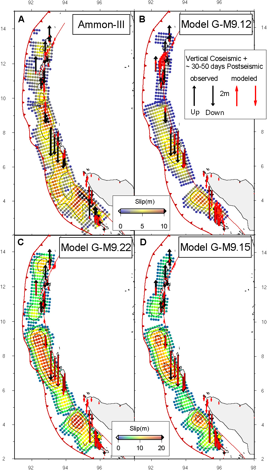
Figure 1. Observed (black) and Predicted (red) vertical displacements associated to model Ammon-III [Ammon et al. 2005] (A, See figure 5 in the main text), model G-M9.12 (B, figure 6), model G-M9.22 (C, figure 7) and our preferred coseismic model G-M9.15 (D, figure 9 in the main text).
Ammon, C. J., Ji, C., Thio, H. K., Robinson, D., Ni, S. D., Hjorleifsdottir, V., Kanamori, H., Lay, T., Das, S., Helmberger, D., Ichinose, G., Polet, J., and Wald, D., 2005, Rupture process of the 2004 Sumatra-Andaman earthquake: Science, v. 308, p. 1133-1139.
Bilham, R., Engdahl, R., Feldl, N., and Satyabala, S. P., 2005, Partial and complete rupture of the Indo-Andaman plate boundary 1847-2004: Seism. Res. Lett., v. 76, p. 299-311.
Gahalaut, V. K., Nagarajan, B., Catherine, J. K., Subhash, K., and Sinha, M. S., 2006, Constraints on 2004 Sumatra-Andaman earthquake rupture from GPS measurements in Andaman-Nicobar Islands: Earth And Planetary Science Letters, v. in press.
Hashimoto, M., Choosakul, N., Hashizume, M., Takemoto, S., Takiguchi, H., Fukuda, Y., and Frjimori, K., 2006, Crustal deformations associated with the great Sumatra-Andaman earthquake deduced from continuous GPS observation: Earth Planets and Space, v. 58, p. 127-139.
Jade, J., Ananda, M. B., Dileep Kumar, P., and Banerjee, S., 2005, Co-seismic and post-seismic displacements in Andaman and Nicobar Islands from GPS measurements: Current Science, v. 88, p. 1980-1984.
Meltzner, A. J., Sieh, K., Abrams, M., Agnew, D. C., Hudnut, K. W., Avouac, J.-P., and Natawidjaja, D. H., 2006, Uplift and subsidence associated with the great Aceh-Andaman earthquake of 2004: J. Geophys. Res., v. 111, p. doi:10.1029/2005JB003891.
Subarya, C., Chlieh, M., Prawirodirdjo, L., Avouac, J. P., Bock, Y., Sieh, K., Meltzner, A., Natawidjaja, D., and McCaffrey, R., 2006, Plate-boundary deformation associated with the great Sumatra–Andaman earthquake: Nature, p. doi: 10.1038/nature04522.
Vigny, C., Simons, W. J. F., Abu, S., Bamphenyu, R., Satirapod, C., Choosakul, N., Subarya, C., Socquet, A., Omar, K., Abidin, H. Z., and Ambrosius, B. A. C., 2005, Insight into the 2004 Sumatra-Andaman earthquake from GPS measurements in southeast Asia: Nature, v. 436, p. 201-206.
[ Back ]