March/April 2000
Guest Columnist:
Anne F. Sheehan
Campus Box 399
Department of Geological Sciences and CIRES
University of Colorado
Boulder, CO 80309
afs@mantle.colorado.edu
MICROEARTHQUAKE STUDY OF THE COLORADO FRONT RANGE:
COMBINING RESEARCH AND TEACHING IN SEISMOLOGY
Introduction
The level of seismicity in Colorado has been characterized as being low to moderate (Kirkham and Rogers, 1981) due in part to the lack of adequate seismographic coverage in the state. The largest known historical earthquake in Colorado was the 8 November 1882 earthquake, whose size (estimated Richter magnitude ML 6.2-6.6) and location (somewhere in north-central Colorado) remain controversial (McGuire et al., 1982; Spence et al., 1996). The best documented earthquakes in Colorado have been those induced by the disposal of waste fluids at the Rocky Mountain Arsenal near Denver (Evans, 1966; Healy et al., 1968; Herrmann et al., 1981) and secondary oil recovery in western Colorado (Gibbs et al., 1973). The largest instrumentally recorded natural earthquake in Colorado was a magnitude 5.5 event in 1960 which occurred near Ridgeway in southwest Colorado (Talley and Cloud, 1962).
As noted above, earthquakes have occurred in geographic locations spread throughout the region. Occasional microearthquake surveys of limited extent have been conducted in the past (e.g., Goter and Presgrave, 1986; Keller and Adams, 1975), and the U.S. Bureau of Reclamation currently operates two small seismograph networks in southwest Colorado. In addition, Microgeophysics Corporation operated a seismograph network in the Front Range under contract to the Denver Water Board from 1983-1993. Current seismic station coverage in the state of Colorado is extremely poor, with stations only at Golden, Idaho Springs, Paradox Valley, and Ridgeway (southwest Colorado) reporting times to the NEIC. Thus, the PDE catalog offers a very incomplete view of Colorado seismicity, with a magnitude threshold of about 3.0 and large location uncertainties in most parts of the state.
Despite the low to moderate levels of historical seismicity, there is significant geologic evidence of late Quaternary tectonic activity throughout the state of Colorado, particularly in the Front Range, the Uinta uplift, and the Uncompaghre uplift, and associated with the Rio Grande Rift (e.g., Colman, 1986; Ely et al., 1986; Epis and Chapin, 1975; Gable and Hatton, 1983; McCalpin, 1986; Widmann et al., 1998). The scarp-morphology data from the Rio Grande Rift in south-central Colorado suggest that the youngest movements on the scarps occurred between 5,000 and 15,000 years ago (Colman, 1986). On the Sangre de Cristo Fault Zone in south-central Colorado, within the northern Rio Grande Rift Zone, Quaternary deposits are offset by up to 87 m and fault scarp data suggest past earthquakes of magnitude 7 to 7.3 (McCalpin, 1986).
The contemporary crustal stress regime in Colorado includes extension along a roughly northeast-oriented axis (Bott and Wong, 1995). A possible mechanism for seismogenesis in the area is reactivation of existing faults, which are oriented favorably to the contemporary stress field, i.e., oriented west-northwest to northwest. Focal mechanisms of two of the earthquakes related to the Rocky Mountain Arsenal fluid injection have indicated normal (or extensional) fault movement locally in the northern Front Range region (Wong, 1986).
In the fall of 1996, a small seismic array was deployed around Boulder, Colorado, both to map local microseismicity patterns and to provide hands-on training in earthquake seismology to undergraduate students at the University of Colorado. Using three sensors deployed by the field geophysics class, and incorporating data from two other local United States Geological Survey (USGS) stations, earthquakes within a radius of approximately 50 km of the array were recorded and analyzed.
Instrumentation and Deployment
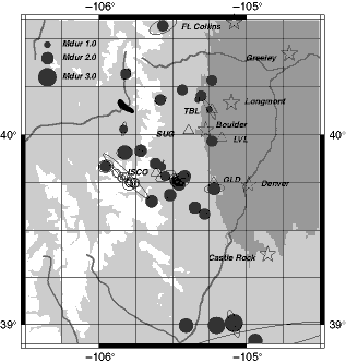
The seismic instrumentation used in this experiment consisted of three Reftek 72A-08 data-acquisition systems and three Mark Products L4-3D three-component seismometers. The Reftek recorders were purchased using funds from an NSF Undergraduate Instrumentation and Laboratory Improvement (ILI) grant (http://www.ehr.nsf.gov/ehr/due). The seismometers were deployed in 2.5-foot-deep holes lined with sections of PVC pipe and the instruments were powered by 12V heavy-duty marine batteries charged by two solar panels per site. Data were stored on external disks, which were swapped at station service visits. The disks were of sufficient size to hold many weeks' worth of data. The instruments were deployed at Sugarloaf Mountain (SUG), Louisville (LVL), and Table Mountain (TBL), with station spacing of approximately 15 km (Figure 1). The instruments were in place from August 1996 through November 1996, with one station (TBL) left in place through September 1997. Each station recorded continuously at 40 samples/s with an additional triggered data stream of 100 samples/s. The triggered stream was used to teach students about the concept of triggering, including its advantages and disadvantages over continuous recording. USGS stations used to complement the Boulder network included stations ISCO (Idaho Springs, Colorado) and GLD (Golden, Colorado).
|
|
Pedagogy
Students were involved with all phases of the network deployment and data analysis. After an initial lecture on the basics of earthquake seismology and seismic networks, the class deployed the sensors. One of the seismic stations (TBL) was deployed with the entire fourteen-student class, and the other stations (SUG and LVL) were deployed by two teams of seven students each. Goals of the sensor deployment exercise included (1) gain hands-on experience at setting up a seismic network, (2) learn how to pick a satisfactory site for a seismic station, (3) learn about triggering of data streams, (4) learn how to program the data-acquisition system and determine proper acquisition parameters to use, and (5) learn about the GPS system and its use in timing and locations. The SUG and LVL sites were less than ideal, with the SUG site in a wooded area and LVL near a busy road. The students were able to learn for themselves why good site selection is critical (the lack of sunlight to the solar panels at station SUG resulted in power problems at night, and station LVL had poor data quality during the day due to traffic). The full course Web page, including photographs of the deployment and general instructions on siting seismic stations, can be found at http://cires.colorado.edu/people/sheehan.anne/geol4740.html.
The sensor deployment was done during the first week of classes, and the students serviced the stations after approximately five weeks. The data were downloaded onto a Sun workstation by one of the students in the class, and the students participated in a data analysis exercise. During the data analysis exercise the students learned the basics of the UNIX operating system, use of a seismological data analysis package, and principles of filtering and time series analysis. The students' assignment was to detect and locate a local earthquake and to find a teleseismic earthquake and describe it. The students were provided with the QED list of earthquakes for the time period of the deployment, selected a teleseismic event of interest, and then used travel-time tables to determine when the event should arrive at the Boulder stations. They then examined the event on the Boulder stations, described the seismograms, and tried their hand at filtering in order to improve signal quality. For the local earthquake exercise, the students perused the data in order to find an event that was recorded at all three stations. They picked P and S times and performed the location by simple triangulation. They also examined whether the event appeared on both triggered and continuous data streams.
As with many class assignments, the seismic network exercise drew mixed reviews from the students. The field geophysics course is a two-credit course that meets two full afternoons a week for eight weeks. The focus of the course is on shallow subsurface geophysics including gravity, magnetics, electrical resistivity, seismic refraction, and ground-penetrating radar. The earthquake seismology exercise did not have a shallow subsurface focus, unlike the other field projects. Most students enjoyed the variety this assignment introduced to the course. They also enjoyed learning about their professor's area of research focus. Many students found "discovering" earthquakes that were undetected by the NEIC to be both surprising and exciting. However, some students did not like the diversion from the focus of the course on shallow subsurface geophysics. During the deployment exercise, it is important to keep the students engaged and minimize the time they spend watching someone else (usually the instructor) operate the equipment (this holds true for any field exercise). During the site preparation, students alternated between site preparation (digging and building the vault) and determining the location of the site using topographic maps, single-station GPS, and differential GPS. The seismic data analysis laboratory can pose a challenge, since most students had little or no experience with UNIX.
Recruiting several graduate students to help with the computer exercise gave the undergraduates a less frustrating and more productive experience. In follow-up work, undergraduate student Noah Hughes performed additional analysis of the Boulder seismic network for his undergraduate senior honors thesis. Indeed, such small deployments are ideally suited for undergraduate research projects.
Fitting the seismic deployment into the already tight course schedule is difficult. In a subsequent graduate seismology course, a single station was serviced and data from the deployment were analyzed at a more advanced level, but we chose not to repeat the full deployment. In a more recent offering of the field geophysics course two broadband stations were deployed by the students and the student servicing trip was eliminated.
Data Analysis and Results
All data were downloaded to a UNIX workstation and phase arrival picks were made using PASSCAL Quick Look (pql) software and later the Datascope/Antelope dbpick software. Coda lengths were obtained from each station with satisfactory background noise levels for use in duration magnitude determination. This duration, or coda length, is defined as the time duration elapsed between the P-wave arrival (initiation of event signal) and the point at which the signal decays to twice the strength of the background noise. The program HypoInverse (Klein, 1978) was used to determine earthquake location.
A crustal velocity model for the Colorado Front Range from Prodehl and Lipman (1978) was used. Formal epicenter location error ellipses from HypoInverse are shown in Figure 1. The formal error ellipses are probably a minimum bound on the uncertainties in epicentral location, and assume that the velocity model used is correct and all picks are properly weighted. Event depths fall in the range 0-20 km beneath the surface, but the uncertainties are large, in some cases several tens of kilometers. Events outside the network have degraded location uncertainties, with increased sensitivity to the velocity model assumed. Minor changes in the velocity model can move these epicenters by several tens of kilometers, while events inside the network are essentially unaffected. Magnitudes were determined for each event using a coda duration method (e.g., Lawson, 1978). For each event the magnitude was determined using the following formula:
Mdur = 1.86[log(coda length)] - 0.85
where coda length is given in seconds. Our duration magnitude scale was determined by regression of three events recorded by both our network and the USGS NEIC.
Events located during this experiment are shown on Figure 1. Twenty-three small seismic events were located within a 50-mile radius of Boulder during the first three months of the deployment, with an additional twenty-four events located during 1997. The earthquakes ranged from duration magnitude 1.0 to 2.9, and include a cluster of five magnitude 2.6-2.8 earthquakes located near Castle Rock, Colorado. An apparent southeast to northwest alignment of events west of Golden, Colorado (station GLD) is observed and may delineate an active fault. This orientation correlates well with the seismogenic characteristics previously proposed (Bott and Wong, 1995; Wong, 1986; Widmann et al., 1998). The earthquakes produced by this fault could indicate the reactivation of a pre-existing fault in response to regional extension. The majority of other events were located almost exclusively in the mountains and foothills west of Denver rather than in the plains to the east. No events were found near the former Rocky Mountain Arsenal northeast of Denver, which was the site of extensive induced seismicity in the late 1960's and early 1970's (Evans, 1966; Healy et al., 1968; Herrmann, 1981). The map also shows a clustering of events near a known hard rock quarry in Clear Creek Canyon 20 km southeast of station ISCO (Idaho Springs, Colorado) and another approximately 20 km southwest of station ISCO. Events were identified as blasts based on location, origin time statistics, and waveform character. Blasts were excluded from the catalog and the b-value statistics.
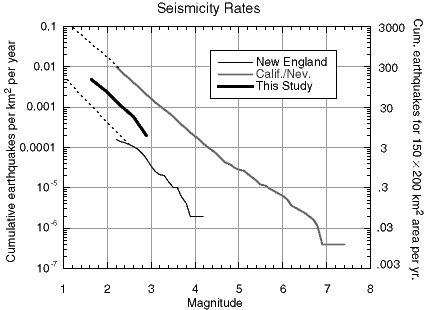
An earthquake frequency analysis was performed and was compared to sample catalogs from California and western Nevada (Gross and Jaume, 1995) and New England (Doll and Toksöz, 1997) (Figure 2). Both the California and New England catalogs represented a five-year period. All data were normalized to earthquakes per square kilometer per year. The b-value plot for this small sample suggests a seismicity level for the Front Range of approximately midway between that of the California/Nevada region and that of New England. The Colorado values obtained from this deployment are comparable to seismicity levels estimated from historic records of earthquakes in Colorado (Unruh et al., 1994). An extrapolation of the line for this region suggests a recurrence interval for a magnitude 6 earthquake to be between 100 and 1,000 years for the Colorado Front Range (approximately 200 km X 150 km area). However, the window of magnitudes sampled by this project is narrow and this extrapolation is tenuous. A permanent or long-term array in the area would produce more reliable recurrence intervals.
|
|
Conclusions
Overall, the array recorded and located thirty-one microearthquakes during the one-year period from September 1997-September 1998, with many more events identified as quarry blasts. The seismic events ranged in magnitude from Mdur 1.0 to Mdur 2.9. An alignment of microearthquakes along a northwest-southeast trending line just west of Golden, Colorado agrees with the geometry of a previously recorded alignment of microearthquakes (Unruh et al., 1994). Furthermore, the alignment seems to correspond to generally northwest-southeast-trending fault geometries of the area. The overall seismicity level recorded by this array suggests a recurrence interval of between 100 and 1,000 years for an event similar to the M 6.6 that shook the region in 1882.
The array provided a valuable learning experience for students in an undergraduate field geophysics course and in a graduate observational seismology course. It was also well suited for an undergraduate honors project. In addition to basic principles of seismology, by participating in this project the students were able to gain experience in instrument deployment, time series analysis, statistics, and inverse theory, and not only catch a glimpse of but actually participate in real seismological research.
Acknowledgments
We thank the Fall 1996 Field Geophysics class (GEOL 4740) at the University of Colorado for installation of the array and initial data analysis. Robert Erickson, Linda Figueroa, Jody Hvorka, and the Table Mountain Geophysical Observatory graciously allowed us to deploy stations on their property. Craig Jones provided assistance with database issues, Noah Hughes took responsibility for many aspects of the deployment and initial data analysis, and Scott Cook and Lynda Lastowka helped with event identification and picking arrival times. Madeleine Zirbes and Ray Buland helped with obtaining USGS National Network seismic data. Funding for the instrumentation was provided by the National Science Foundation through the Undergraduate Education Program and the Research Experience for Undergraduates Program (NSF DUE-9551264). Further funding was provided by Cooperative Institute for the Research of Environmental Sciences (CIRES) through the Colorado Commission for Higher Education.
References
Bott, J.D.J. and I.G. Wong (1995). The 1986 Crested Butte earthquake swarm and its implications for seismogenesis in Colorado, Bull. Seism. Soc. Am. 85, 1,495-1,500.
Colman, S.M. (1986). Morphology and age of fault scarps in the Rio Grande Rift, south-central Colorado, in Contributions to Colorado Seismicity and Tectonics: A 1986 Update, Colorado Geological Survey Special Publication 28, 43-58.
Doll, C. and M.N. Toksöz (1997). MIT New England seismic network: Data analysis and dissemination tools, Seism. Res. Lett. 68, 816.
Ely, R.W., I.G. Wong, and P.S. Chang (1986). Neotectonics of the Uncompahgre Uplift eastern Utah and western Colorado, in Contributions to Colorado Seismicity and Tectonics: A 1986 Update, Colorado Geological Survey Special Publication 28, 75-92.
Epis, R.C. and C.E. Chapin (1975). Geomorphic and tectonic implications of the post-Laramide, late Eocene erosion surface in the southern Rocky Mountains, in Curtis, B. F., ed., Cenozoic History of the Southern Rocky Mountains, Geol. Soc. Am. Memoir 144, 45-74.
Evans, D.M. (1966). The Denver area earthquakes and the Rocky Mountain disposal well, The Mountain Geologist 3, 23-26.
Gable, D.J. and T. Hatton (1983). Maps of vertical crustal movements in the conterminous United States over the last 10 million years, USGS Misc. Investigation Series Map I-1315.
Gibbs, J.F., J.H. Healy, C.B. Raleigh, and J. Coakley (1973). Seismicity in the Rangely, Colorado, area: 1962-1970, Bull. Seism. Soc. Am. 63, 1,557-1,570.
Goter, S.K. and B.W. Presgrave (1986). Preliminary results of the 1984 Carbondale, Colorado earthquake field study, in Contributions to Colorado Seismicity and Tectonics: A 1986 Update, Colorado Geological Survey Special Publication 28, 162-163.
Gross, S. and S. Jaume (1995). Historical Seismicity in the Southern Great Basin, internal report for USGS YMSCPO, 127 pp.
Healy, J.H., W.W. Rubey, D.T. Griggs, and C.B. Raleigh (1968). The Denver earthquakes, Science 161, 1,301-1,310.
Herrmann, R.B., S.K. Park, and C.Y. Wang (1981). The Denver earthquakes of 1967-1968, Bull. Seism. Soc. Am. 71, 731-745.
Keller, G.R. and H.E. Adams (1975). A reconnaissance microearthquake survey of the San Luis Valley, Southern Colorado, Bull. Seism. Soc. Am. 65, 345-347.
Kirkham, R.M. and W.P. Rogers. Earthquake potential in Colorado, Colorado Geol. Survey Bull. 43, 171 pp.
Klein, F.W. (1978). Hypocenter location program HypoInverse, U.S. Geological Survey Open-File Report 78-694.
Lawson, J.E., Jr. (1978). A preliminary duration magnitude scale for local and regional earthquakes recorded at Oklahoma seismograph station: Oklahoma Geophys. Obs. Open-File Report, 14 pp.
McCalpin, J. (1986). Quaternary tectonics of the Sangre de Cristo and Villa Grove Fault Zones, in Contributions to Colorado Seismicity and Tectonics: A 1986 Update, Colorado Geological Survey Special Publication 28, 59-64.
McGuire, R.K., A. Krusi, and S.D. Oaks (1982). The Colorado earthquake of November 7, 1882: Size, epicentral location, intensities, and possible causative fault, The Mountain Geologist 19, 11-23.
Prodehl, C. and P.W. Lipman (1989). Crustal structure of the Rocky Mountain region, in Pakiser, L.C., and W.D. Mooney, Geophysical Framework of the Continental United States: Boulder, Colorado, Geol. So. of Am. Memoir 172, 249-284.
Spence, W., C.J. Langer, and G.L. Choy (1996). Rare, large earthquakes at the Laramide Deformation Front: Colorado (1882) and Wyoming (1984), Bull. Seism. Soc. Am. 86, 1,804-1,819.
Talley, H.C. and W.K. Cloud (1962). United States Earthquakes 1960, U.S. Coast and Geodetic Survey, 90 pp.
Unruh, J.R., I.G. Wong, C.S. Hitchcock, J.D.J. Bott, W.J. Silva, and W.R. Lettis (1994). Seismotectonic evaluation, Pueblo Dam, Fryingpan-Arkansas Project, South-Central Colorado, U. S. Bureau of Reclamation final report, Denver, Colorado, October.
Widmann, B.L., R.M. Kirkham, and W.P. Rogers (1998). Preliminary Quaternary fault and fold map and database of Colorado, Colorado Geological Survey Open File Report 98-8, 331 pp.
Wong, I.G. (1986). Tectonic stresses in Colorado and their implications to seismicity, in Contributions to Colorado Seismicity and Tectonics: A 1986 Update, Colorado Geological Survey Special Publication 28, 17-27.
SRL encourages guest columnists to contribute to "EduQuakes." Please contact Larry Ruff with your ideas. His e-mail address is eduquakes@seismosoc.org.
Posted: 24 March 2000
URL's updated: 21 January 2003