|
|
Publications: SRL: Historical Seismologist |

Historical Seismologist
September/October 2008
The 1494 and 1680 Málaga (Southern Spain) Earthquakes
T. Goded, E. Buforn, and D. Muñoz
Universidad Complutense de Madrid
INTRODUCTION
In 1494, the city of Málaga, in southern Spain, was shaken by an earthquake that caused significant damage throughout the entire Málaga province. Two centuries later, in 1680, another destructive shock caused even greater damage in Málaga city and nearby towns. Because the area has experienced a great deal of urbanization over the past 30 years, another large earthquake in this region could have devastating consequences. With this in mind, we have undertaken a reappraisal of the damages caused by these two historic earthquakes, using new documents found in archives, libraries, etc.
Earthquakes in the Málaga region are associated with the plate boundary between Eurasia and Africa. The seismicity of this region is characterized by the occurrence of moderate earthquakes, with magnitudes in general less than 5.0, at shallow depth (h < 40 km; Figure 1A). There is also important seismic activity at intermediate depth (40 < h < 150 km) with a N-S distribution of epicenters near Málaga (Buforn et al. 1995). The distribution of historical shocks with maximum MSK (Medvedev-Sponheuer-Karnik scale) intensities equal to or larger than VIII (Figure 1B) shows an important concentration of large earthquakes along the Spanish coast. According to Instituto Geográfico Nacional (IGN) data files, three events with maximum EMS-98 (European Macroseismic Scale) intensities equal to or greater than VII have occurred in the Málaga region: 1494 (VIII), 1581 (VII), and 1680 (VIII–IX) (Martínez Solares and Mezcua 2002). The last damaging event in the area was the 1884 Arenas del Rey (Granada) earthquake (I0 = IX–X; Muñoz and Udías 1981), which caused significant damage in Málaga city (Figure 1B). This study focuses on earthquakes with epicenters near Málaga city, so the 1884 earthquake is not considered.
THE 1494 EARTHQUAKE
On 26 January 1494, a large shock occurred in the south of Spain. It was felt in a great number of towns along the Málaga coast as well as some of the towns located inland, such as Granada or Seville, at about 200 km from Málaga city. Martínez Solares (1995) and Olivera (1995) have studied this earthquake, obtaining new information such as the exact date of occurrence and an intensity map. According to Martínez Solares and Mezcua (2002), the epicenter was located at 36°35’N, 4°20’W (Figure 2). In the present study, new documentation has been found, including six contemporary documents (Table 1, Appendix A) with additional information about the damages caused by this earthquake in the city of Málaga. The estimated intensities based on this new information are shown in Figure 2 and Table 2. Different factors have been assigned to the intensity values according to the quality of the information available. Quality factor A has been given to towns where the information is detailed enough to assign a reliable intensity value. Quality factor B is given to towns where the information about damages is good, but not as detailed as quality A. Finally, quality factor C has been assigned when the description of the damage is very poor and the evaluated intensity is doubtful. In Table 2 and Figure 2, “F?” means that the earthquake was probably felt, because it is mentioned in the documents, but no accurate information about the damages is described, while “?” is assigned to the town of Bezmiliana, where repairs were made after the earthquake but no mention of the shock was found in the documents. For Málaga, Benalmádena, Almogía, and Fuengirola, the intensities have been estimated using contemporary documents.
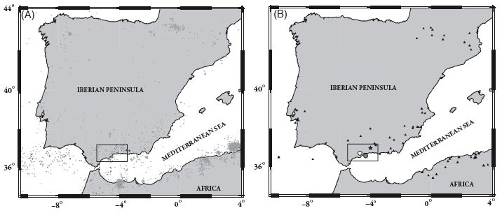
▲ Figure 1. Instrumental and historical seismicity for the Iberian Peninsula (IGN data file). The marked area corresponds to the Málaga region. 1A: Distribution of epicenters for the period 1980–2004 (M ≥ 3.5). Light gray circles correspond to shallow earthquakes (h < 40 km), dark gray to intermediate depth (40 < h < 150 km), and white circles with black boundaries to very deep earthquakes (h > 600 km), in the Granada region. 1B: Historical seismicity for earthquakes with Imax ≥ VIII MSK. Gray circle corresponds to the 1494 Málaga earthquake, white circle to the 1680 earthquake, and the star to the Arenas del Rey 1884 shock.
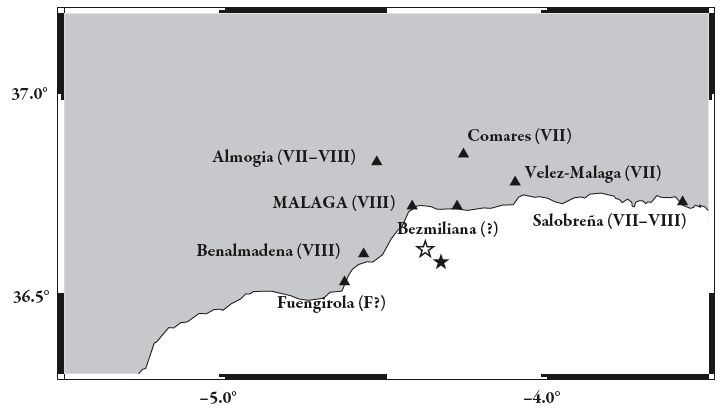
▲ Figure 2. Intensity map for the 26 January 1494 Málaga earthquake (EMS-98), corresponding to the marked area in Figure 1. The stars show the epicenters proposed by Martínez Solares and Mezcua (2002) (in black) and the one proposed in this study (in white). “F?” means that the earthquake was probably felt at that town.
| TABLE 1 New Contemporary Documents Found for the 1494 Málaga Earthquake (Appendix A) |
|||
|---|---|---|---|
| Reference | Description | Year | Archive/Library |
| A.M.M. (1494a) | Letter from Francisco Serrano to the Catholic kings applying for financial aid for Málaga city | 1494 | Archivo Municipal de Málaga |
| A.M.M. (1494b) | Letter from the city of Málaga to Fernando Aluares corroborating the facts described in the A.M.M. (1494a) reference | 1494 | Archivo Municipal de Málaga |
| A.M.M. (1494c) | Memorial from the city of Málaga to the Catholic kings with the damage description and asking for financial help | 1494 | Archivo Municipal de Málaga |
| A.M.M (1494d) | Letter from Francisco Serrano to the city of Málaga describing the state of the financial help requested to the kings | 1494 | Archivo Municipal de Málaga |
| A.M.M. (1495a) | “Repartimientos de Málaga” (October): descriptions of the damaged houses of Málaga | 1495 | Archivo Municipal de Málaga |
| A.M.M. (1495b) | “Repartimientos de Málaga” (November): damage descriptions in the houses of Málaga | 1495 | Archivo Municipal de Málaga |
| TABLE 2 Intensities for the 1494 Málaga Earthquake |
|||
|---|---|---|---|
| Location | Intensity (EMS-98) | Contemporary documents? | Quality factor |
| Málaga | VIII | YES | A |
| Benalmádena | VIII | YES | A |
| Almogía | VII–VIII | YES | B |
| Salobreña | VII–VIII | NO | C |
| Vélez-Málaga | VII | NO | C |
| Comares | VII | NO | C |
| Fuengirola | F? | YES | C |
| Bezmiliana | ? | NO | C |
According to the information found in the documents, the damages caused by the 1494 earthquake may be summarized as follows. In Málaga city (intensity EMS-98 VIII), most of the houses were destroyed, and the city walls and towers suffered great damage. The Trinitarios convent was completely destroyed, and as a result of the damages suffered it was moved to another site. The Catholic kings spared the city from paying taxes for two years. In Benalmádena (VIII), most of the houses were destroyed as well as part of the City Hall, and most of the inhabitants were forced to move to other towns within the region. In Almogía (VII–VIII) significant damages appeared at the fortress (part of the walls and one of the towers fell down), as well as in the town’s furnace and stables. In 1518 the Spanish Crown ordered the payment of 125,000 maravedíes (a maravedi is the smallest Spanish copper coin with an equivalence of 1 ducat = 375 maravedíes; the ducat was the standard gold monetary unit) to the town of Almogía for reparations made after the earthquake. In Salobreña (VII–VIII) severe damages affected the fortress; the reparation expenses were estimated at 225,000 maravedíes. In Vélez-Málaga (VII) the city walls and towers were damaged, and the kings spared the town from the payment of taxes for four years. In Comares (VII) important reparations were made at the fortress a month after the shock, and there was a 40% decrease in the population between 1492 and 1495, most probably due to the earthquake. In Fuengirola (F?), the earthquake was felt but no precise information has been found. In Bezmiliana (?), there were some building reparations made in 1494 between January and April, but the reason is unknown (Goded 2006). In comparison to the Martínez Solares and Mezcua (2002) study (where only intensity values are given), the intensity of this earthquake has decreased for Vélez-Málaga (from ≥ VII to VII), and it has increased for Benalmádena (VII to VIII), Salobreña (VI–VII to VII–VIII), and Comares (from ≥VI to VII). The intensities have quality factor A for Málaga and Benalmádena, B for Almogía, and C for the rest of the towns. From these results (Figure 2) we propose an epicenter at 36.62°N, 4.37°W, very close to the Martínez Solares and Mezcua (2002) proposal.
THE 1680 EARTHQUAKE
On 9 October 1680, another large earthquake caused very serious damage in the city of Málaga. The surrounding area was heavily damaged, and the shock was felt in many cities in the center and south of Spain, as far as Toledo, Madrid, and Valladolid (more than 500 km from Málaga). Two different hypocentral locations have been proposed in other studies on this earthquake (Table 3). The damages caused in Málaga city have been thoroughly studied by Muñoz and Udías (1988). However, we have found more than 30 new references for the Málaga region, including five contemporary sources (Table 4; Appendix B), and as a result it has been possible to re-evaluate the earthquake using the new data. The EMS-98 scale has been used to assign the intensity values (Table 5; Figure 3), focusing our study on the towns near Málaga. Quality factors have also been assigned in a way similar to the 1494 earthquake. Most of the towns studied have intensities with quality factors A or B (Table 5) due to the detailed information found in the documents and in contrast to the 1494 earthquake, where most of the intensities have only quality factor C.
In comparison to the Muñoz and Udías study (1988: Figure 3A), the intensity values have changed for six towns (out of a total of 14 towns evaluated; see Figure 3B). The intensity has decreased for Alhaurín de la Torre, Benalmádena (from VIII–IX to VIII), and Álora (from VIII to VII), while it has increased for Antequera (VII to VII–VIII), Ronda and Vélez- Málaga (VI–VII to VII) due to the new information found in both primary and secondary sources. The differences in the intensity values could also be due to the different intensity scale used: MSK in the Muñoz and Udías (1988) study and EMS-98 in our study, with more detailed damage descriptions for each intensity value. Muñoz and Udías (1988) included a table with intensity values. This table has been used for the comparison with the values obtained in this study.
In 1680, the city of Málaga was divided into four parishes: Sagrario, San Juan, Santos Mártires, and Santiago. A detailed study of the damages in these parishes has been carried out using the new information found for this earthquake. The San Juan and Santos Mártires parishes were the most damaged. In both of them, around 25% of the houses were completely destroyed. Only 5% of the houses in Santos Mártires parish were left habitable. In San Juan parish there were 24 dead and at least 61 injured, and in Santos Mártires 11 people were killed and 20 injured. The Sagrario and Santiago parishes were less damaged. Fifteen percent of houses were completely destroyed and two people were injured in Sagrario; in Santiago parish 10% of houses were completely destroyed, 23 people were injured, and one person was killed (Muñoz and Udías 1988; Goded 2006). In our study, new information about the people killed in San Juan, Sagrario, and Santiago parishes was found in secondary sources that included the victims’ names and the streets where they were killed, confirming that the earthquake was the cause of death.
| TABLE 3 Focal Parameters of the 1680 Málaga Earthquake |
||||||||
|---|---|---|---|---|---|---|---|---|
| Date | Time | Latitude | Longitude | Imax | Mw | h (km) | M0 (Nm) | Location |
| 10/9/1680 | 7.00 or 7.15 | 36.7 °N | 4.7° W | VIII–IX (MSK) | 6.6 | 50 | 1019 | W of Málaga1 |
| 10/9/1680 | 7h 00m | 36°48’N | 4°36’W | VIII–IX (EMS-98) | 6.8 | — | — | NW of Málaga2 |
| 1. Muñoz and Udías (1988) | ||||||||
| 2. Martínez Solares and Mezcua (2002) | ||||||||
| TABLE 4 New Contemporary Documents Found for the 1680 Málaga Earthquake (Appendix B) |
|||
|---|---|---|---|
| Reference | Description | Year | Archive/Library |
| A.D.E.U. (1681a) | Letter from King Carlos II to the city of Málaga. The city is spared payment of taxes for six years due to the earthquake and the plague that affected the region since 1678 | 1681 | Archivo Díaz de Escovar y Urbano, Museo de Artes Populares. Málaga |
| A.D.E.U. (1681b) | Letter from King Carlos II to the city of Málaga. Same content as the document A.D.E.U. (1681a) | 1681 | Archivo Díaz de Escovar y Urbano, Museo de Artes Populares, Málaga |
| A.D.E.U. (XVIIth century) | Italian copy of one of the Spanish memorials with the damages’ descriptions in Málaga and the towns nearby | XVIIth century | Archivo Díaz de Escovar y Urbano, Museo de Artes Populares, Málaga |
| A.H.M.V.M. (1680) | Act from Vélez-Málaga with the description of the damages in some houses of the town | 1680 | Archivo Histórico Municipal de Vélez-Málaga |
| B.N. (1680) | Letter from the Bishop of Málaga containing the description of the damages caused by the earthquake and the inhabitants’ behavior during the shock | 1680 | Biblioteca Nacional, Madrid |
| TABLE 5 Intensities for the 1680 Málaga Earthquake |
|||
|---|---|---|---|
| Location | Intensity (EMS-98) | Contemporary Documents? | Quality Factor |
| Málaga | VIII–IX | YES | A |
| Alhaurín el Grande | VIII–IX | YES | A |
| Alozaina | VIII–IX | YES | B |
| Cártama | VIII–IX | YES | A |
| Coín | VIII–IX | YES | A |
| Mijas | VIII–IX | YES | C |
| Pizarra | VIII–IX | YES | A |
| Alhaurín de la Torre (*) | VIII | YES | B |
| Benalmádena (*) | VIII | YES | C |
| Cómpeta | VIII | YES | B |
| Antequera (*) | VII–VIII | YES | B |
| Álora (*) | VII | YES | B |
| Ronda (*) | VII | YES | C |
| Vélez-Málaga (*) | VII | YES | B |
| (*) Different values in Muñoz and Udías (1988) | |||
We also studied the damage caused by this earthquake to 36 specific buildings in Málaga city (Figure 4 and Table 6), 17 more than were included in the Muñoz and Udías study. Most of these were churches and monasteries. Six buildings were completely destroyed (damage grade 5 EMS-98 scale), 17 suffered damage grade 4, and the rest suffered damage grades 3 and 2. Some of the available information is very detailed. For example, we found that the San Francisco monastery in Santos Mártires parish had to be rebuilt from its foundations and four friars were killed and six injured. These buildings were made of simple stone or manufactured bricks, so a vulnerability class B has been assigned, according to the EMS-98 scale. The only exception is the cathedral, made of massive stone (vulnerability class C). There is a considerable difference in the type of construction between these monuments and the houses of ordinary citizens, made from earthen brick or rubble stone and thus assigned a vulnerability class A.
The new intensity values from this study have allowed us to obtain new hypocentral coordinates. The attenuation coefficient a and the depth of the earthquake have been estimated from an attenuation law of the type:
I0 − I = a × log √x2+h2
h
where I0 is the epicentral intensity, a the attenuation coefficient, x the epicentral distance, and h the depth of the focus. An attenuation curve has been obtained, together with the value a = 6, the same as in Muñoz and Udías (1988), with a shallower focus (40 km versus 50 km). This high attenuation factor agrees with the values obtained by other authors for the same area (Muñoz et al. 1974; López Casado et al. 2000). From the attenuation curve, the new estimated epicenter is 36.66°N, 4.77°W, almost beneath the town of Coín and 7 km to the southwest of the Muñoz and Udías (1988) epicenter (Figure 3B).
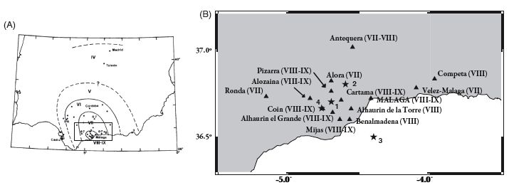
▲ Figure 3. (A) Isoseismal map for the 1680 earthquake by Muñoz and Udías (1988) and marked area studied in the present work. (B) Intensity map for the 9 October 1680 Málaga earthquake (EMS-98), corresponding to the marked area in Figures 1 and 3(A). The stars show the four proposed epicenters for this earthquake: 1: Muñoz and Udías (1988); 2: Martínez Solares and Mezcua (2002); 3: IGN tsunamis catalog; 4: this study.
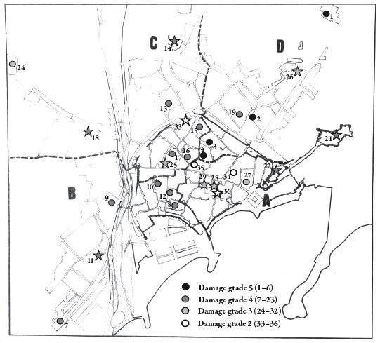
▲ Figure 4. Málaga monuments damaged in the 1680 earthquake (modified from Muñoz and Udías 1988). References correspond to Table 6. Stars show the new monuments evaluated in this study (see Table 6). The four parishes of the city are marked: Sagrario (A), San Juan (B), Santos Mártires (C), and Santiago (D). It has not been possible to locate seven monuments of Table 6, because most of them are now private houses.
| TABLE 6 Building Damages in the City of Málaga (1680 Earthquake, EMS-98 scale) |
||||
|---|---|---|---|---|
| Reference | Building | Parish | Damage Grade | Vulnerability Class |
| 1 | San Francisco de Paula Monastery | Santiago | 5 | B |
| 2 | Nuestra Señora de la Paz Monastery | Santiago | 5 | B |
| 3 | San Bernardo Monastery | Santiago | 5 | B |
| 4 | Santa Clara Monastery | Santiago | 5 | B |
| 5* | Don Diego Argote’s house | ? | 5 | A |
| 6* | Don Juan de Torres’ house | ? | 5 | A |
| 7 | Carmelitas Descalzos Monastery | San Juan (arrabal del Perchel) | 4 | B |
| 8 | Trinitarios Descalzos Monastery | San Juan | 4 | B |
| 9 | Santo Domingo Monastery | San Juan | 4 | B |
| 10 | San Juan Church | San Juan | 4 | B |
| 11* | San Pedro en los Percheles Church | San Juan (arrabal del Perchel) | 4 | B |
| 12 | Clérigos Menores’ School | San Juan | 4 | B |
| 13 | San Francisco Monastery | Santos Mártires | 4 | B |
| 14* | Capuchinos Monastery | Santos Mártires | 4 | B |
| 15 | Encarnación Monastery | Santos Mártires | 4 | B |
| 16 | Dominicas Monastery | Santos Mártires | 4 | B |
| 17 | Santos Mártires Church | Santos Mártires | 4 | B |
| 18* | San Pablo Church | Santos Mártires | 4 | B |
| 19 | Nuestra Señora de la Merced Monastery | Santiago | 4 | B |
| 20 | Agustinas Descalzas Monastery | Sagrario | 4 | B |
| 21* | Gibralfaro Castle | Santiago | 4 | B |
| 22* | Alcazaba | Santiago | 4 | B |
| 23* | Don Diego de Córdoba’s house | ? | 4 | A |
| 24 | Ángeles Trinitarios Calzados Monastery | Santos Mártires | 3 | |
| 25* | Compañía de Jesús Monastery | Santos Mártires | 3 | B |
| 26* | Nuestra Señora de la Victoria Monastery | Santiago | 3 | B |
| 27 | Recoletas Bernardas del Císter Monastery | Sagrario | 3 | B |
| 28* | Sagrario Church | Sagrario | 3 | B |
| 29* | Episcopal House | Sagrario | 3 | B |
| 30* | Seminar School | Sagrario | 3 | B |
| 31* | Governor’s house | ? | 3 | A |
| 32* | Cabildo’s house | ? | 3 | A |
| 33* | San Juan de Dios Monastery | Santos Mártires | 2 | B |
| 34 | San Agustín Monastery | Sagrario | 2 | B |
| 35 | Carmelitas Descalzas Monastery | Sagrario | 2 | B |
| 36* | Cathedral | Sagrario | 2 | C |
| * New buildings in relation to the Muñoz and Udías (1988) study | ||||
DISCUSSION
For the 1680 earthquake it has been possible to estimate the intensity in 14 towns versus a total of eight for the 1494 event. Only three cities have been evaluated in both earthquakes (Málaga, Benalmádena, and Vélez-Málaga, Figures 2 and 3). The low number of towns evaluated for the 1494 shock may be explained by the historic context: the 1494 earthquake occurred only seven years after the conquest of the province of Málaga by the Catholic kings, and consequently only the towns where the defensive fortresses suffered some damage made reports, whereas other damages were not reported. On the other hand, an important plague that devastated Málaga province beginning in 1678 may explain why the information of the damages for the 1680 earthquake was only provided for those towns with the greatest intensity values: other towns with less damage were probably not reported because the scourge of the plague would surely have been of greater concern for the inhabitants.
The 1680 earthquake has a larger maximum intensity (VIII–IX) than the 1494 event (VIII), and it was felt at greater distances. According to the 1494 intensity map (Figure 2), the damage in this event was concentrated along the coast following an E-W direction. In the 1680 shock, the damage shows a N-S distribution (Figure 3). Another difference between these two earthquakes is their depth. For the 1680 event, Muñoz and Udías (1988) have proposed an intermediate depth focus (50 km) based on the attenuation curve obtained and on the large area where the earthquake was felt, in agreement with the new depth of 40 km proposed in this study. However, the 1494 event seems to have been a shallow earthquake with a much higher attenuation than the 1680 shock, which can be shown in the difference in the intensity values for three cities far from the epicenters: Carmona and Granada have been evaluated with intensity ≥ IV and Seville with “?” for the 1494 earthquake (Martínez Solares 1995), in comparison to the intensity VI assigned to the same three cities for the 1680 shock (Muñoz and Udías 1988; Martínez Solares and Mezcua 2002).
Figure 5 shows the main geological faults (Sanz de Galdeano, personal communication), together with the proposed epicenters for both shocks. The epicenter proposed by Martínez Solares and Mezcua (2002) for the 1494 shock is located offshore, near a NE-SW fault. According to Figure 2 the epicenter for the 1494 event may indeed be the one proposed by Martínez Solares and Mezcua (2002), given the pattern of damage observed along the coast. However, other faults in the region could also be responsible for the 1494 earthquake, although the information available at present is not enough to assign the shock to other faults.
For the 1680 earthquake, we propose a hypocenter southwest of Málaga, very close to the one proposed by Muñoz and Udías (1988; Figure 5). The Martínez Solares and Mezcua (2002) epicenter is located northwest of Málaga city where intensities are lower. The Muñoz and Udías proposed site is a macroseismic epicenter, whereas the Martínez Solares and Mezcua epicenter has been obtained using the Bakun and Wentworth (1997) method for California, modified for the Iberian Peninsula by Mezcua et al. (2004). From the Mezcua et al. (2004) study we can conclude that for the earthquakes with both instrumental and macroseismic data (used as master events) there seems to be a systematic deviation of the epicenters to the north. This deviation is probably due to the few training events used by the authors. The marine epicenter proposed in the Spanish Tsunamis Catalogue of the IGN, which preserves the same location given in older catalogs (Munuera 1963; Mezcua and Martínez Solares 1983), is not supported by the available information in contemporary documents. There is great contradiction between different documents: some of them say “the Sea level arose around 5m,” while others clearly say “the Sea was calm during the earthquake.” Mention of the sea elevation is given in only two documents, of which one of them (“Así fue el terremoto” 1680), was published in Paris and was very probably a copy from the other (Archivo Histórico Nacional 1680). We consider this information very exaggerated, because if the sea level rose there would surely have been a flood in the city of Málaga, and no evidence of such flood has been found. In addition, one document explains that the noise arrived at Málaga city from the region near Mijas, located southwest of the city (Biblioteca Nacional 1680). This is very relevant information, because it seems to show that the earthquake came from inland, that is, from the southwest, which would contradict both the hypothesis of an offshore epicenter and the occurrence of a tsunami. Finally, if a tsunami really occurred after the earthquake, there should have been some evidence of it in Morocco, but no supporting information has been found. The earthquake—but not a tsunami—is mentioned in Morocco in a unique reference about the event found by Vincent (1986): “On the morning of 15 Ramadan (October 9), there was also an earthquake, and the shooters’ brigade came out of Fez to make some Jihad practice in Tangier.” We therefore can say that no conclusive information about a possible tsunami has been found. If we assume a depth of 40–50 km and an inland epicenter according to the damage distribution, this focus is incompatible with the occurrence of a tsunami associated with the earthquake.
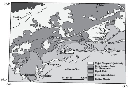
▲ Figure 5. Main geological features for the Málaga region (personal communication, Sanz de Galdeano, CSIC, Granada), together with the proposed epicenters for the 1494 (black star: Martínez Solares and Mezcua 2002; white star: this study) and 1680 earthquakes: black triangle (Muñoz and Udías 1988), white circle (Martínez Solares and Mezcua 2002), white square (IGN tsunami catalog), and white triangle (this study)
CONCLUSIONS
The 1494 and 1680 earthquakes are representative of the seismicity in the Málaga region, with two different origins. The 1494 shock may be considered a shallow earthquake associated with the geological faults with an NE-SW trend that are present in this area (Sanz de Galdeano 1983). The maximum intensity was VIII (EMS-98), with the largest damages located along the coast of Málaga. The 1680 earthquake was larger (Imax = VIII–IX), with an inland epicenter to the west of Málaga city. The distribution of damages in a N-S direction and the depth of 40–50 km show a different origin for this event, which may be correlated with the seismicity at intermediate depth in this area (Buforn et al. 1995). The occurrence of a tsunami associated with this earthquake is not supported by the information found in the contemporary documents. The great damage caused by the 1680 earthquake shows that the intermediate depth seismicity must be taken into account if one is to obtain a realistic estimate of the seismic risk in this area.
![]()
ACKNOWLEDGMENTS
This work has been funded partially by the Spanish Ministerio de Educación y Ciencia ERSE (Realistic Seismic Risk Scenarios in Spain, REN2003-5178-C03-01) and RISTE (Earthquakes and Tsunamis Risk in Spain, CGL2006-10311-C03-01) projects and FPU grant (AP2005-0181) of T. Goded. The authors wish to thank Dr. C. Sanz de Galdeano (Instituto Andaluz de Ciencias de la Tierra, CSIC, Granada), who provided the geological information for the Málaga region; Dr. J. M. Martínez Solares (Universidad Complutense de Madrid), for providing documents for the 1494 earthquake; and Dr. M. Reder (Universidad de Málaga), for her help in the research and transcription of historical documents.
REFERENCES
Archivo Histórico Nacional, Madrid (1680). Segunda relacion del horrible Temblor de Tierra que padeciò la Ciudad de Malaga el Miercoles 9. de Octubre deste año de 1680. Refierense las circunstancias que faltaron a la Primera, assi de lo sucedido en dicha Ciudad, como en todos los Lugares de sus Contornos.
Así fue el terremoto (1680). París. Oficina de noticias de las galerias del Louvre, ante la calle Santo Tomás. 20 de noviembre de 1680 (con privilegio). In Vincent, B. (1986). El terremoto de Málaga de 1680, Historia 16 120, 32-33.
Bakun, W. H., and C. M. Wentworth (1997). Estimating earthquake location and magnitude from seismic intensity data. Bulletin of the Seismological Society of America 87, 1,502–1,521.
Biblioteca Nacional, Madrid (1680). Relacion verdadera de la lastimosa Destruicion, que padeciò la Ciudad de Malaga, por el espantoso Terremoto que sucediò el Miercoles 9. De Octubre deste presente año de 1680. V. E. 69-4 and 69-71.
Buforn, E., C. Sanz de Galdeano, and A. Udías (1995). Seismotectonics of the Ibero-Maghrebian region. Tectonophysics 248, 247–261.
Goded, T. (2006). Reevaluación de daños de los terremotos de Málaga de 1494 y 1680. Trabajo de Investigación. Universidad Complutense de Madrid, 152 pps.
López Casado, C., S. Molina Palacios, J. Delgado, and J. A. Peláez (2000). Attenuation of intensity with epicentral distance in the Iberian Peninsula. Bulletin of the Seismological Society of America 90, 34–47.
Martínez Solares, J. M. (1995). Catálogo sísmico. In Sismicidad histórica del Reino de Granada (1487–1531), 9–35. Madrid: Instituto Geográfico Nacional.
Martínez Solares, J. M., and J. Mezcua (2002). Catálogo sísmico de la Península Ibérica (880 a.C.–1900). Instituto Geográfico Nacional. Madrid, 253 pps.
Mezcua, J., and J. M. Martínez Solares (1983). Sismicidad del área Ibero-Mogrebí. Publicación 203. Instituto Geográfico Nacional. Madrid, 299 pps.
Mezcua, J., J. Rueda, and R. M. García Blanco (2004). Reevaluation of historic earthquakes in Spain. Seismological Research Letters 75, 75–81.
Munuera, J. M. (1963). A study of seismicity on the Península Ibérica area. Instituto Geográfico y Catastral.
Muñoz, D., A. López Arroyo, and J. Mezcua (1974). Curvas medias de variación de la intensidad sísmica con la distancia epicentral. In Memorias 1a Asamblea Nacional de Geodesia y Geofísica, 327–339. Madrid: Instituto Geográfico Nacional.
Muñoz, D., and A. Udías (1981). Estudio de los parámetros y serie de réplicas del terremoto de Andalucía del 25 de diciembre de 1884, y de la sismicidad de la región de Granada-Málaga. In El Terremoto de Andalucía de 1884, 95–125. Madrid: Instituto Geográfico Nacional.
Muñoz, D., and A. Udías (1988). Evaluation of damage and source parameters of the Málaga earthquake of 9 October 1680. Historical Seismograms and Earthquakes of the World, ed. W. H. K. Lee, H. Meyers, and K. Shimazaki, 208–221. San Diego: Academic Press.
Olivera, C. (1995). Geografía y poblamiento. In Sismicidad histórica del Reino de Granada (1487–1531), 37–283. Madrid: Instituto Geográfico Nacional.
Sanz de Galdeano, C. (1983). Los accidentes y fracturas principales de las Cordilleras Béticas. Estudios Geológicos 39, 157–165.
Vincent, B. (1986). El terremoto de Málaga de 1680. Historia 16 120, 32–33.
Appendix A. New Contemporary Documents for the 1494 Málaga Earthquake (See Table 1)
Archivo Municipal de Málaga (hereafter, A.M.M.) (1494a). Carta de Francisco Serrano, corregidor de Málaga, a los Reyes Católicos solicitando que les quiten el diezmo y medio ante las grandes pérdidas y daños ocasionados por el terremoto y otros problemas que afectan a la ciudad. Actas Capitulares de 1494. 4 marzo 1494. Fol. 283v. Reproduced in the capitular acts of May 21st 1494.
A.M.M. (1494b). Carta de la ciudad de Málaga a Fernando Aluares. Actas Capitulares de 1494. 4 marzo 1494. Fol. 270.
A.M.M. (1494c). Memorial que envía la ciudad de Málaga a los Reyes Católicos suplicándoles que provean sobre determinados asuntos, entre ellos el terremoto de 1494. Actas Capitulares de 1494. 4 marzo 1494. Fol. 268v.
A.M.M. (1494d). Carta de Francisco Serrano a la ciudad de Málaga. Actas Capitulares de 1494. 3 mayo 1494. Fol. 279v.
A.M.M. (1495a). Repartimientos de Málaga. 1 octubre 1495. Libro III. Fol. 69.
A.M.M. (1495b). Repartimientos de Málaga. 24 noviembre 1495. Libro II. Fol. 154.
Appendix B. New Contemporary Documents for the 1680 Málaga Earthquake (see Table 4)
Archivo Díaz de Escovar y Urbano (hereafter, A.D.E.U.) (1681a). Real cédula de Carlos II, con motivo del terremoto de 1680. Notas manuscritas de J. Díaz de Escovar. Cédula del 18 de enero de 1681. Museo de Artes Populares. Málaga. Caja n° 220.
A.D.E.U. (1681b). Real cédula de Carlos II, con motivo del terremoto de 1680. Notas manuscritas de J. Díaz de Escovar. Cédula del 10 de febrero de 1681. Museo de Artes Populares. Málaga. Caja n° 220.
A.D.E.U. (XVIIth century). Relatione veridica della lagrimevole distruttione, che pasi la citta de Malaga per il spantoso terremoto succedido il mercordi 9 otobre 1680. Tradotta della lingua Spagnola nell Italiana. Museo de Artes Populares. Málaga. Caja n° 220.
Archivo Histórico Municipal de Vélez-Málaga (hereafter, A.H.M.V.M.) (1680). Vélez-Málaga. Málaga. Actas Capitulares. Sección primera. Sig. II-1-16. Años 1681–1687. Cabildo de 25 de abril de 1681. Fol. 14r.
Biblioteca Nacional (hereafter, B.N.) (1680). Alonso de Santo Tomás (Obispo de Málaga) (1680). Carta pastoral al Illustrissimo y Reverendissimo Señor D.F. Alonso de S. Tomas, Obispo de Malaga. A los pieles de su Obispado en el tiempo que Dios N. Señor castigo esta ciudad y su comarca con un temblor de tierra. Málaga. 16 de octubre de 1680. Madrid, VE/196/123, 14 pps.
Departamento de Geofísica y Meteorología
Facultad de Ciencias Físicas
Universidad Complutense de Madrid. Avda
Complutense s/n. 28040, Madrid, Spain
tgoded [at] fis [dot] ucm [dot] es
(T.G.)
[Back]
Posted: 25 September 2008