|
|
Publications: SRL: Historical Seismologist |

Historical Seismologist
November/December 2008
Southern California Earthquake during the 1775 Anza Expedition
Max Suter
Universidad Nacional Autónoma de México
An earthquake with a Modified Mercalli intensity of five was felt on 26 December 1775 by a Spanish colonial expedition led by Juan Bautista de Anza in present-day Riverside County (southeastern California), at the southeastern end of the Cahuilla Valley, near the San Jacinto fault system (Figure 1). After the well-documented earthquakes felt in the Los Angeles basin during the Gaspar de Portolá expedition 28 July to 3 August 1769 (Bancroft 1884; for a summary see Ellsworth 1990; Kovach 2004), this is the second-earliest documented event in the earthquake history of southern California. The 1775 event was cursorily mentioned by Townley and Allen (1939) and Toppozada et al. (1981) but is not listed in the 1769–2000 catalog of magnitude 4 and greater earthquakes by the California Geological Survey (http://www.consrv.ca.gov/cgs/rghm/quakes), whereas the 5.5 cut-off magnitude in the more recent listings of historical earthquakes by Toppozada et al. (2002) and Toppozada and Branum (2002) was too high for this event to be included.
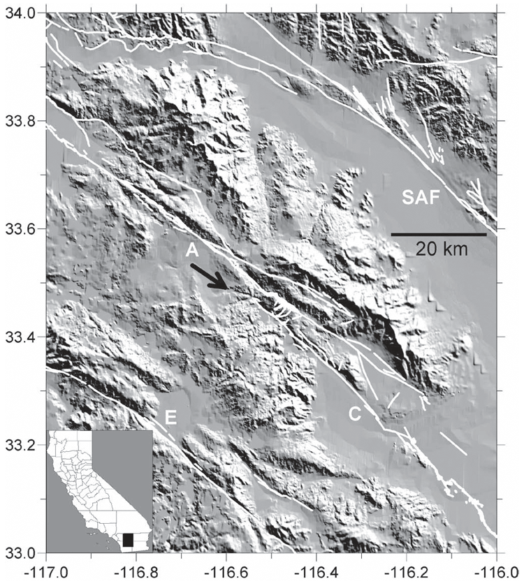
▲ Figure 1. Shaded relief map indicating the campsite of the Anza expedition (arrow) at Puerto de San Carlos, between Nance Canyon and the Terwilliger Valley, southeast of the town of Anza, where the 26 December 1775 earthquake was felt. Also shown are the fault traces documented in the Quaternary fault database of the USGS Earthquake Hazards Program (http://earthquake.usgs.gov/qfaults): A: Anza section; and C: Coyote Creek section of the San Jacinto fault zone; SAF: San Andreas fault zone; E: Elsinore fault zone. Inset: Map of California.
The Anza expedition began at San Miguel de Horcasitas, Sonora, on 29 September 1775 and left Tubac, Sonora, on 23 October 1775. The 240 participants, among them 110 children, trekked with a stock herd along the Gila River to its junction with the Colorado River, and from there to Misión San Gabriel de los Temblores in the Los Angeles basin, which they reached 4 January 1776 (Montané Martí 1989). From San Gabriel, the colonists proceeded to Monterey, Alta California, and from there to the bay area to become the first settlers of San Francisco. Remarkably, all but one of the 240 participants survived the arduous 1,600-km journey, and so did three infants born on the way (Bolton 1930a).
The earthquake was felt by the participants on the 89th day of the expedition (at their 55th camp), on 26 December 1775, when they traveled from Coyote Canyon (now part of the Anza- Borrego Desert State Park) to the Cahuilla Valley, roughly halfway between the lower Colorado River at Yuma and Mission San Gabriel. The earthquake observation is recorded in Anza’s diary and in two journals written by Pedro Font, chaplain and cartographer of the expedition. These three sources were transcribed, translated, and annotated by Bolton (1930b, 1930c). The original manuscript by Anza (which he completed 20 March 1777) is in the Mexican National Archives in Mexico City (Archivo General de la Nación, Provincias Internas, vol. 169, 177–325). Of the two journals by Font, the earlier and shorter one (which he concluded at Ures, Sonora, 23 June 1776) is in the National Library of Mexico in Mexico City (Biblioteca Nacional de México, Archivo Franciscano, manuscript 323), whereas a later and more detailed version (which he concluded at Tubutama, Sonora, 11 May 1777) is archived in the John Carter Brown Library in Providence, Rhode Island.
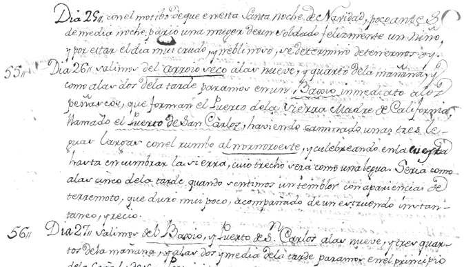
▲ Figure 2. Description of the 26 December 1775 earthquake in the original manuscript of Font’s shorter diary (archived at Biblioteca Nacional de México, Archivo Franciscano), which is posted online at http://lyncis.dgsca.unam.mx/franciscanos
/busquedaDocumento.html (manuscript 323, image 16). A journal by Miguel Costansó of the 1769 Portolá expedition, reporting the earthquakes felt by the expedition in the Los Angeles basin between 28 July 1769 and 3 August 1769, can be viewed on the same Web site (manuscript 311).
Based on Anza’s diary (Tuesday, 26 December 1775), “Rain continued until half past four in the afternoon. After it began to get dark a heavy, distant thunder was heard, and this was followed by an earthquake which lasted four minutes” (Bolton 1930b, 71–72). Based on the short version of Font’s diary (55th camp of the expedition, 26 December 1775), “It must have been about five o’clock in the afternoon when we felt a tremor which appeared to be an earthquake of very short duration, accompanied by short, sharp rumbling” (Bolton, 1930b, 232). This part of Font’s manuscript is reproduced in Figure 2. In the long version of his diary, he writes: “It must have been about five in the afternoon when we felt a tremor of very short duration that appeared to be an earthquake accompanied by short, sharp rumbling. After a short time, it was repeated very indistinctly” (Bolton, 1930c, 158). Based on these observations (felt by all, rumbling sound reported, duration estimated, described as multiple shocks), I estimate the intensity as five on the Modified Mercalli scale (version by Brazee 1979).
Based on the detailed descriptions by Font, Bolton (1930a) retraced the trail of the expedition up Coyote Canyon to what the diarists called “Puerto de San Carlos” (116.61° W/33.49° N, Figure 1), which is the water gap in the mountain range delimiting the Cahuilla Valley in the south. A related historical plaque was mounted in 1924 to a rock face west of the gap on the basis of Bolton’s identification. According to Bolton (1930a), the camp (26–27 December 1775) was located a quarter mile south of the pass near a permanent spring. In present-day place names, the campsite is in Riverside County between Nance Canyon and the Terwilliger Valley (USGS 24k quadrangle Bucksnort Mountain), southeast of the town of Anza, southwest of Coyote Canyon Road.
Bolton (1930a) noted that this location is along the San Jacinto fault zone. Based on the 2002 California fault parameter database of the California Geological Survey (http://www.consrv.ca.gov/CGS/rghm/psha), the site where the earthquake was felt is located near the northern end of the Coyote Creek section of the San Jacinto fault zone (Figure 1), a vertical right-lateral strike slip fault, 41 ± 4 km long, with a slip rate of 4.0 ± 2.0 mm/yr. The site is also close to the Anza section of the San Jacinto fault zone (Figure 1), 91 ± 9 km long, with a slip rate of 12.0 ± 6.0 mm/yr (Petersen and Wesnousky 1994). The southern half of the Coyote Creek section ruptured to the surface in the 9 April 1968 MW = 6.5 Borrego Mountain earthquake (Clark 1972). The 25 March 1937 ML = 6.0 Terwilliger Valley (116.27° W / 33.41° N) and the 19 March 1954 MW = 6.4 Clark fault (116.18° W / 33.28° N) earthquakes (Southern California Earthquake Data Center, http://www.data.scec.org) originated somewhat east of the campsite of the Anza expedition.
A magnitude can be assigned to the 1775 earthquake based on the chronicler’s intensity observations at Puerto Real de San Carlos, though this is a highly uncertain endeavor. A regression of reported maximum MM intensity values for earthquakes in California (Toppozada 1975) gives ML = 1.85 + 0.49 Imax with a standard error of ± 0.60. Based on this equation, Imax = 5 corresponds to ML = 4.3. It is likely that the magnitude of this event was at least 4. The omission of this event in the catalog of M ≥ 4 earthquakes by the California Geological Survey raises the question of how much additional information about historical earthquakes in southwestern North America during the Spanish Colonial and Mexican periods could be gleaned from research in Spanish and Mexican archives. ![]()
REFERENCES
Bancroft, H. H. (1884). History of California, vol. 1, 1542–1800. San Francisco: A. L. Bancroft & Company, 744 pps.
Bolton, H. E. (1930a). Anza’s California Expeditions, vol. 1. Berkeley: University of California Press, 529 pps.
Bolton, H. E. (1930b). Anza’s California Expeditions, vol. 3, Berkeley: University of California Press, 436 pps.
Bolton, H. E. (1930c). Anza’s California Expeditions, vol. 4. Berkeley: University of California Press, 552 pps.
Brazee, R. J. (1979). Reevaluation of Modified Mercalli intensity scale for earthquakes using distance as determinant. Bulletin of the Seismological Society of America 69, 911–924.
Clark, M. M. (1972). Surface Rupture along the Coyote Creek Fault. USGS Professional Paper 787, 55–86.
Ellsworth, W. L. (1990). Earthquake History, 1769–1989, in The San Andreas Fault System, California, ed. R. E. Wallace, 153–187. USGS Professional Paper 1515.
Kovach, R. L. (2004). Early Earthquakes of the Americas. Cambridge, U.K.: Cambridge University Press, 268 pps.
Montané Martí, J. C. (1989). Juan Bautista de Anza, Diario del primer viaje a la California, 1774. Sonora, Mexico: Sociedad Sonorense de Historia, Hermosillo, Sonora, Mexico, 121 pps.
Petersen, M. D., and S. G. Wesnousky (1994). Fault slip rates and earthquake histories for active faults in southern California. Bulletin of the Seismological Society of America 84, 1,608–1,649.
Toppozada, T. R. (1975). Earthquake magnitude as a function of intensity data in California and western Nevada. Bulletin of the Seismological Society of America 65, 1,223–1,238.
Toppozada, T. R., C. R. Real, and D. L. Parke (1981). Preparation of Isoseismal Maps and Summaries of Reported Effects for pre-1900 California Earthquakes. California Division of Mines and Geology Open-File Report 81-11, 182 pps.
Toppozada, T. R., and D. M. Branum (2002). California earthquakes of M ≥ 5.5: Their history and the areas damaged, in International Handbook of Earthquake and Engineering Seismology, ed. W. H. K Lee, H. Kanamori, P. C. Jennings, and C. Kisslinger, part A, 793– 796. San Diego: Academic Press, and file ToppozadaFull.pdf on the attached Handbook CD.
Toppozada, T. R., D. M. Branum, M. S. Reichle, and C. L. Hallstrom (2002). San Andreas fault zone: M ≥ 5.5 earthquake history. Bulletin of the Seismological Society of America 92, 2,555–2,601.
Townley, S. D., and M. W. Allen (1939). Descriptive catalog of earthquakes of the Pacific coast of the United States 1769–1928. Bulletin of the Seismological Society of America 29, 1–297.
[ Back ]
Posted: 25 September 2008