Electronic Supplement to
Prevalence of Earthquake Lights Associated with Rift Environments
by Robert Thériault, France St-Laurent, Friedemann T. Freund, and John S. Derr
INTRODUCTION
This supplement includes a complete description of 60 of the 65 earthquakes associated with luminosities that are listed in tables 1 and 2 and located in figures 1 and 2 of the article. A more detailed description of EQL is also given for the other five cases that are already described in the paper. These descriptions of earthquake and accompanied EQL are a necessary complement to the analysis and interpretation given in the paper. The references for this supplement are given at the end of the text. Numbers after each title correspond to the listings in Table 1 (earthquakes from the Americas) and Table 2 (earthquakes from Europe).
DESCRIPTION OF OTHER EARTHQUAKES ASSOCIATED WITH LUMINOSITIES
The Americas (see Table 1 and Figure 1 of the paper)
Eastern North America
Saguenay earthquake - 1988 November 25, 18h46; EQL descriptions only : (1)
As described by St-Laurent (2000), here are witness descriptions of EQL sighted prior to, during and after the foreshock and main shock:
- On November 12, eleven days before the foreshock, a bright purple-pink globe of light was sighted over the St. Lawrence River near the city of Québec, located 150 km to the south of the epicenter. The globe of light moved at a steady pace over the river towards the NNE for 2-3 minutes, then extinguished itself before the eyes of the two witnesses (Figure S1a). A few airports were contacted, but they were told that no aircraft flew in this sector at that time.
- Less than one minute before the mainshock, about 20 km to the NNE of the epicenter, a trapper was emerging from the forest just to the east of the city of Laterrière. The sky was clear, the wind very calm and there was no frost on the trees. A crackling noise emitted by the trees suddenly came from the direction of the epicentral area. The noise sped by him, passing by his location at the same time as a large luminous body in contact with the ground appeared before his eyes. The witness then felt the shock. The moving luminous body, estimated to have measured about 15 m in height and at least 600 m in width, rapidly disappeared at the horizon opposite to where it came from. Note that [1]the witness was situated approximately along a WSW-ENE oriented regional fault that transects the Saguenay Graben.
- Here is a witness report from Saint-Prime, located 100 km to the WNW of the epicenter: “...two or three minutes after the mainshock, looking through the window, I saw a very small ball of fire (orange) with a very long narrow tail, passing in a straight line and with great speed in the middle of the street, about one meter above the ground...” (Figure S1b). The city of Saint-Prime is located at the western end of the Saguenay Graben south wall.
- Shortly after a weak aftershock that occurred on November 26, a witness living in Sacré-Coeur (a village situated 105 km to the ENE of the epicenter) recalls: “...looking through a large window, I saw a large ball of fire with a long tail. It passed beside my house very low under the telephone pole, crossing the street and going straight down into a ditch behind a house...”. The village of Sacré-Coeur is located in the eastern part and along the north wall of the Saguenay Graben.
- During a mild M 2.5 aftershock that occurred on November 26 at 03h10, two witnesses were driving in the city of Jonquière, located 30 km to the north of the epicenter. As they were making a U-turn in a parking lot along the Arvida bridge road, they saw, a few meters away, a flame-like luminosity issuing from the paved road in a repetitive manner. Note that a SW-NE lineament is present in this immediate area as well as a lamprophyre dyke outcrop.
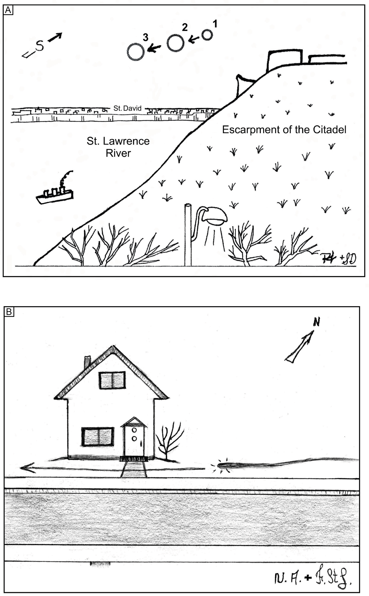
▲Figure S1. A) Sketch showing a globe of light moving towards the NNE over the St. Lawrence River in Quebec City. The sketch represents the view of the two witnesses while they were looking through the dining room window of their 3rd floor apartment. The globe of light was seen 11 days prior to the foreshock of the Saguenay earthquake series. Originally drafted by one of the witnesses (Richard Thériault), and recently edited by Simona Derr. B) Sketch showing a small “ball of fire” with a long narrow tail passing in front of the witness’s front neighbour’s house, city of Saint-Prime, about 2-3 minutes after the main shock of the Saguenay earthquake series. Originally drafted by the witness Nathalie Asselin, and recently edited by France St-Laurent.
Saint-Fidèle (Charlevoix) earthquake - 1979 August 19, 18h49: (2)
The mbLg 5.0 Saint-Fidèle earthquake is the strongest to have occurred in the Charlevoix seismic zone since 1952. The intensity reached V on the Modified Mercalli (MMI) scale, both at the epicenter and 110 km to the NNW in the city of Chicoutimi. The earthquake was also felt in Maine (U.S.A.) and in New-Brunswick (Canada). Among eleven aftershocks, three were felt on August 20, the last one at 19h11, mbLg 3.0 (Wetmiller et al., 1981). The epicenter was situated along the northwestern margin of the SW-NE oriented St. Lawrence Rift, approximately 8 km to the SE of Saint-Fidèle.
On August 20 (exact time not specified), from the north sector of the city of Chicoutimi, three newspaper delivery boys saw luminous globes travelling very rapidly over the Saguenay River in a SE direction. At one time, a luminous red globe was seen near and encircling the Sainte-Anne’s cross (which is located on a cliff above the north side of the Saguenay River), before continuing its way towards the SE while emitting reddish flashes of light. Another flashing globe was also noticed over a very tall tree. The only sound heard, reminiscent of a soft wind-like sound, was when the ball of light was near the cross, which was close to their location (Martel, 1979).
Charlevoix area earthquake, 1663 February 05, 17h30: (3)
The Charlevoix area earthquake occurred within or nearby the astrobleme-related Charlevoix seismic zone, which is the most seismically active area of eastern Canada (Roy and Du Berger, 1983; Lamontagne, 1987, 1998; Baird et al., 2010). The magnitude of the earthquake was estimated by Gouin (2001) at mbLg 6.5, while Locat (2008, 2011) recently proposed a magnitude ranging between 7.2 +/- 0.2 and 7.8 +/- 0.6 based on empirical methods. The later interpretation is supported by the work of Ebel (2011), who interpreted a best estimate for the moment magnitude of 7.5 +/- 0.45, based on attenuation relations using a MMI scale. The circular meteorite impact structure measures about 55 km in diameter, and is transected in its central part by the SW-NE oriented St. Lawrence Rift (Lamontagne, 1987, 1998; Lemieux et al., 2003; Baird et al., 2010). Hence the origin of the earthquake could be related either to fault movement along this paleorift or to normal faults bordering the astrobleme-related structure.
The following is a description of luminous phenomena made by Père Hierosme Lalemant (Lalemant, 1663), a Jesuit living in the city of Québec: “The 5th of February, around 5:30 at night, a strong noise was heard at the same time in all of Canada (i.e. Province of Québec). This noise, which preceded and accompanied the quake, sounded like a house caught on fire… We also saw “sparks of fire” sliding on roofs without causing any harm other than fear… We saw fires, torches and flaming globes which sometimes fell to the earth and sometimes disolved in the air… The atmosphere was not without disturbance…”.
Newbury earthquake, 1727 November 09, 22h40 : (4)
The mb 5.6 Newbury earthquake is estimated to have been located just to the NW of the city of Newbury, Massachusetts (Ebel, 2000). It was followed the same day by 8 strong aftershocks (M≥ 4) and by about 80 others until the end of December. A series of NE-SW oriented faults occur along the coastal region of northern Massachusetts, New Hampshire and Maine, among which the Clinton-Newbury and Bloody Bluff faults, which extend in the immediate area just north of Newbury (Bothner and Hussey II, 1999; Hon et al., 2007; Tuttle, 2008). Directly to the south of the Bloody Bluff fault are alkalic intrusive rocks of the Boston-Avalon Terrane, which are interpreted to have been emplaced within a rifting, back-arc environment (Hon et al., 2007). Furthermore, the location of the epicenter falls within a NW-SE oriented corridor of locally intense seismicity that corresponds to the track of the Great Meteor hot spot (Morgan, 1983; McHone and Butler, 1984; Ma and Eaton, 2007).
The following descriptions of anomalous light phenomena were reported in Gookin (1727): “The shake was very hard, and was attended with a terrible noise, something like thunder; the houses trembled … ; it was specially so in the South Parish where the hardest shake seemed to be on the hill … When the shake was beginning some persons observed a flash at their windows, and one or two saw streams of lights running on the earth, the flame seemed to them to be of a bluish color”. Furthermore, as was reported by The Weekly News-Letter (1727): “Divers people in this, and some neighbouring Parish observed just as the earthquake began, a flash of light at the windows: A young man of this town being then standing abroad near his father house, upon which he saw a flash of light run along upon the ground ’till it came to the house, and then began the shake”. This light was observed in Hampton, New Hampshire, about 15 km N of the epicenter.
Rockland Lake earthquake, 1848 September 08 (no time given): (5)
The ML 4.4 Rockland Lake earthquake occurred about 35 km to the north of the city of New York, along the Hudson River (NY State Office of Emergency Management, 2009). The epicenter was located within the northeastern part of the Newark Basin, which represents a half-graben that formed during the break-up of the supercontinent Pangaea in the Triassic. The earthquake may be related to movement along the Rockland Lake fault, a NE-SW oriented, high angle strike-slip fault that is located along the northeastern margin of the Newark Basin (Lomando and Engelder, 1984).
Flashes of lightning were sighted on the shores of the Hudson River exactly where the shaking had taken place, during which time no clouds were observed in the sky (Perrey, 1850 ; Galli, 1910).
Mooresville earthquake, 1998 June 04, 22h31: (6)
The mbLg 3.7 Mooresville earthquake occurred approximately 30 km to the north of Charlotte, North Carolina (USGS, 1998). The epicenter was located directly along a major, NE-SW oriented, gravity anomaly that extends for over 2000 km from Georgia to Vermont and into Quebec (Cook and Oliver, 1981). This structural feature is interpreted to possibly represent the ancient continental margin of eastern North America, where rifting of the supercontinent Rodinia took place during the Late Precambrian to Early Cambrian (Long, 1979; Thomas, 2006). Reactivation of this rift occurred in North Carolina during the Triassic.
Numerous Mooresville inhabitants called 911 to report a tremendous flash in the sky at the same time as an “explosion” was heard and felt (i.e. earthquake). There was no thunderstorm activity within 80 km, and the sky was clear. Residents of Charlotte, located about 30 km south of the epicenter, also reported seeing a bright flash at the time of the earthquake. The flash was so bright that people thought at first that a meteor had hit the ground (Young, 1998).
Waynesville earthquake, 1916 February 21, 18h39: (7)
The M5.2 Waynesville earthquake was located approximately 50 km to the east of Waynesville, North Carolina (Reagor et al., 1987; Stover and Coffman, 1993). The epicenter was situated along the SE margin of the Blue Ridge province, an interpreted paleorift which formed during the Early Cambrian rifting of Rodinia (Thomas, 2006, 2010). This paleorift is bounded to the SE by the Brevard Zone, a SW-NE oriented, reactivated strike-slip fault that extends for over 700 km from Alabama to Virginia (Gates et al., 1988).
On April 11 at 22h52, fifty days after the main shock, Mr. Martin and Dr. Coffey witnessed two floating spheres of light apparently about the size of an ordinary street lamp seen at a distance of one mile. The lights flashed out among the trees on the eastern slopes of Brown Mountain, about one-eighth of the distance down from the summit. The lights moved in a roughly horizontal plane in a SE direction, floating in and out of ravines and generally following the contour of the land for a distance estimated at 2 miles. After 21 minutes, the lights disappeared as abrutly as they came (Frizzell, 1984). Note that Brown Mountain is also located along the southeastern edge of the Blue Ridge paleorift (i.e. Brevard Zone), about 75 km to the NE of the epicenter, and is well known for its numerous and controversial nocturnal light occurrences that have intrigued residents and visitors for hundreds of years (Mansfield, 1971; Frizzell, 1984; Western North Carolina Attractions, 2013).
Asheville earthquake swarm, 1874 February-May: (8)
The MMI IV-V Asheville earthquakes were located about 40 km to the ENE of Asheville, North Carolina (Reagor et al., 1987). There were a total of over 75 earthquakes between February and May of 1874 (Von Hake, 1975). The epicentral area was located about 40 km to the NE of the Waynesville earthquake of 1916, and also coincides with the southeastern margin of the Blue Ridge paleorift (i.e. Brevard Zone).
The Western Expositor (1874) of Asheville reported the following news from Bald Mountain, which is located about 35 km to the east of Asheville:
“Thursday evening last (May 21), about half past seven, several severe shocks of an earthquake again were observed at Bald mountain equal in severity to any that have preceded them within the last three or four months of these rumblings. A score of persons at different points several miles distant from the mountain, concur in the statement of feeling its effects, especially in the direction of Rutherford county and along Broad river. A strange phenomenon of lights was witnessed by many -- lights which frequently shot up from the mountain. A few nights before Thursday evening's shocks, a party of four or five at Spicer Springs saw a huge light moving up Broad river, which shone with such intensity as to exhibit the trees and hills for an eighth of a mile on each side of the river, as if it were daylight. It shone but five minutes, and disappearing left all in darkness. They describe it as resembling an electric light, or like a mellow line of fire moving up the river. The witnesses were much alarmed at the time, and can offer no explanation of the strange phenomenon”.
Charleston-Summerville earthquake, 1975 April 28, 00h46: (9)
The ML 3.9 Charleston-Summerville earthquake occurred about 5 km to the SW of Summerville and 35 km to the NW of Charleston, South Carolina (Talwani, 1977). The seismicity in the area is interpreted to be related to two different sets of orthogonal faults, which are: 1) the NE-SW oriented Woodstock fault, a 70 km long dextral strike-slip fault; and 2) a series of NW-SE oriented, steeply dipping reverse faults that bisect and locally displace the Woodstock fault to form two parallel segments (i.e. Woodstock North and Woodstock South faults) (Durá-Gómez and Talwani, 2009). The isoseismal data shows a NW-SE oriented trend, with the epicenter being located on the SW flank (Talwani, 1977). This trend is parallel to and along the northwestern extension of a main Triassic transform fault interpreted by Thomas (2006) to be associated with the rifting of Pangaea and formation of the Atlantic Ocean. The epicenter of the earthquake also coincides with the Bermuda hotspot trace (Duncan, 1984; Cox and Van Arsdale, 2002), which, as discussed previously for the Great Meteor hotspot, can be linked locally to intense seismic activity.
Flashes of lightning in the sky were noted by some residents of Summerville about 5 minutes before the earthquake. One woman from Ladson reported that her dog became unusually agitated a few minutes before the quake and gnashed a hole in the door (Talwani, 1977).
Charleston (South Carolina) earthquake, 1886 August 31, at about 21h50: (10)
The Mw 7.3 Charleston (South Carolina) earthquake was located approximately 25 km to the NW of Charleston (Durá-Gómez and Talwani, 2009). As with the Charleston-Summerville earthquake of 1975, it is interpreted to be related to normal faulting along an extensive, early Mesozoic (Triassic) extensional rift basin located between Summerville and Charleston (Chapman and Beale, 2010).
Evidence of EQL was reported by Galli (1910) as follow: “In Summerville (near Charleston), people claim to have heard violent detonations. Some persons profess to have seen the earth spew flames. Large crevasses formed, from which emanated sulphurous fumes”.
New Madrid earthquake, 1811 December 16, 02h15; EQL descriptions only : (11)
Several EQL were documented in relation with the New Madrid earthquake series. An observer near New Madrid saw many sparks of fire emitted from the earth during the main earthquake of December 16, 1811. About 235 km to the NNW of the epicenter, in St. Louis, Missouri (i.e. St. Louis arm of the Reelfoot rift; Braile et al., 1982), gleams and flashes of light were frequently visible along the horizon, the lights generally ascending from the earth's surface. In Livingston County, Kentucky, about 115 km to the NE of the epicenter, the atmosphere previous to the shocks of February 8 was remarkably luminous, objects being visible for great distances although there was no moon (moon was at 0.02 phase). At Bardstown (within the Rough Creek Graben), about 365 km to the ENE of the epicenter, frequent flashing was noticed during the commotion that immediately followed the earthquake of December 16, 1811. At Knoxville, Tennessee, about 500 km to the east of the epicenter, two successive flashes of light separated by about one minute were seen following the first shock. These were described as being very much like distant lightning (no direction given). Lights or glow was also reported from North Carolina (exact location not given) and Savannah, Georgia (Fuller, 1912 ; Corliss, 2001). According to Fuller (1912), some of the lightning flashes reported were probably the result of electrical storms in some localities, especially in the South Carolina region. The weather was also reported to have been clear in the New Madrid area at the time of the earthquake.
Following is an observation made from Hot Spring, North Carolina, located approximately 600 km to the east of the epicenter and along the NW margin of the Blue Ridge rift: “The shock at that place (Dec. 16, 1811) did little damage….The fulminating of the mountains was accompanied with flashes of fire seen issuing from their sides. Each flash ended with a snap, or crack, like that which is heard on discharging an electric battery, but 1000 times as loud” (Hough, 2000).
Charleston (Missouri) earthquake, 1895 October 31, 05h08: (12)
The Ms 6.7 Charleston (Missouri) earthquake is the largest to have occurred in the Mississippi Valley region since the 1811-1812 New Madrid earthquake sequence. People in 23 states felt this earthquake, which caused extensive damage to a number of structures in the Charleston region, which is located 40 km to the NE of New Madrid (Nuttli, 1987; USGS, 2013).
A total of five witness reports were published in the local newspapers of the time (Shrum, 1989): 1) A witness from the Bridges district of Charleston, while looking over the fields just prior to the shock, saw a beautiful electrical display: from the ground shot up numerous shafts of lights all over the field. The lights continued to shine during the most violent part of the disturbance (Charleston Democrat, 1895); 2) Several persons from the city of Kirkwood, a suburb of St. Louis located 200 km to the NW of Charleston (i.e. within the St. Louis arm of the Reelfoot Rift; Braile et al., 1982), reported seeing an electrical phenomenon in the northern skies accompanying the rumbling (St. Louis Globe-Democrat, 1895); 3) A motorman from St. Louis reported to have seen an unusual streak of lights that stretched over the sky as he was passing Natural Bridge road; and 4) From Evansville, Indiana, located 200 km to the NE of Charleston (i.e. within the Southern Indiana arm of the Reelfoot Rift; Braile et al., 1982) the following was reported: “the quake was accompanied by lightning which seemed to cross the sky in waves, being four of them, while a yellow light lit up the northwestern sky” (St. Louis Globe-Democrat, 1895).
Western North America
Merritt earthquake, 2003 August 20, 01h33: (13)
The Mw 3.7 Merritt earthquake occurred about 40 km to the ESE of the city of Merritt and 225 km to the NE of Vancouver, British Columbia. The general area of southern British Columbia is characterized by the presence of numerous NW-SE and N-S oriented, regional faults that are interpreted to have a dominant strike-slip component (Tribe, 2005; Ickert, 2006).
At about 23h30 on August 19, about two hours prior to the earthquake, a witness observed a flash of light just north of the city of Tulameen, British Columbia, located about 50 km to the SW of the epicenter. The witness was standing in front of her cottage, on the shore of Otter Lake, when she saw a white flash of light about in the middle and above the 400-500 m wide lake. The brilliant white beam of light, which according to the witness measured approximately 2-3 feet in length and 2-3 inches in width, positioned itself horizontally about 5 feet above the lake surface. The light remained still for a couple of seconds before moving diagonally towards the lakeshore. As it reached the shore, the light beam moved in front of a large willow shrub located about 10 meters from the witness position, where it suddenly grew brighter and burned into a brilliant neon blue color while simultaneously emitting a loud sound reminiscent of sparklers. The neon blue beam of light then arched over into the nearby bushes behind a log, sparked and fizzled out. The event lasted about 1 to 2 minutes, from beginning to end. The witness remembers checking around the bushes after the light disappeared to see if there were any signs of fire or smoke. She did so again the following morning but there was no evidence of scorching on leaves, branches, ground or near lakeshore vegetation (S. Smart, 2008, pers. comm.).
Note that the area where the light beam manifested itself is within 500 m (to the west) of the NW-SE oriented, regional Otter Lake fault (probably deep seated), which passes along the eastern margin of the lake and extends for about 50 km (Rice, 1947; Morgan, 1973). This fault is intruded by felsic igneous rocks, and is oriented parallel to the major Fraser River strike-slip fault, a crustal scale structure located 40 km to the west that extends for over 500 km into the United States (Coleman and Parrish, 1991).
San Francisco earthquake, 1906 April 18, mainshock at 05h12: (14)
The Mw 7.8 Great 1906 San Francisco earthquake ranks as one of the worst catastrophes in United States history. Horizontal rupture of the right-lateral, San Andreas strike-slip fault was evaluated to have occurred along a fault length of some 477 km, from northwest of San Juan Bautista (located 130 km to the SE of San Francisco) to the Mendocino Triple Junction, south of Eureka. The epicenter was located about 3 km west of San Francisco, near Mussel Rock (Zoback, 2006; USGS, 2013).
Here are excerpts from a letter written by John Barrett, then news editor for the San Francisco Examiner (Alberts et al., 1989): “While standing on Market Street with two reporters after 5h00 am, all of a sudden we found ourself staggering and reeling… It was dark, like twilight (sunrise was at 05h33).... I saw wide wounds in the street and a wild tangle of wires. Some of the wires swayed and shot blue sparks… A deadly odor of gas rose from a broken main… That was what came next–the fire. It shot up everywhere…”. More than 50 fires started within half an hour after the earthquake. (Alberts et al., 1989; Zoback, 2006).
Several occurrences of light phenomena were described in association with this earthquake. The following was reported in Corliss (2001): “The appearance of the blue lights was over a wider area than first thought... At Petaluma, about 50 km north of San Francisco, blue flames eighteen inches in height “played” over a wide expanse of marsh land. Before the earthquake, only a flickering haze was seen above the ground… Blue flames were seen hovering over the base of foothills in western San Francisco… In San Jose, at the time of the shock, Alameda Street was seen ablaze with fire, being of a beautiful rainbow color, but faint”. At a mountain ranch near Cazadero (about 100 km NNW of San Francisco), the two nights preceding the earthquake, a couple saw small streams of lightning running along the ground. Their attention was directed to the phenomenon by incessant barking of their dog (Madeira, 1910). Except for the marsh gases and the Cazadero incident, it is almost impossible here to discriminate between normal glow due to sunrise, wires arcing, morning mist and fires, and anomalous glow that might have been seen by some.
Hollister earthquakes, 1961 April 08, 23h23 and 23h25: (15)
The Hollister twin earthquakes, respectively of magnitude (M) of 5.6 and 5.5, occurred two minutes apart and were both located approximately 20 km to the SSE of the city of Hollister, California (Cloud, 1967). The epicentral area coincides very closely to where the Calaveras fault meets the San Andreas Fault. The former, a right-lateral strike-slip fault, represents a major branch of the San Andreas Fault. It extends for about 200 km, starting south of Hollister, then running sub-parallel and to the east of the San Andreas Fault until it wanes off about 30 km east of San Francisco. It is difficult to determine which of these two strike-slip faults was active at the time of the twin earthquakes, but based strictly on the location given by Cloud (1967), the epicenter was most likely located along the San Andreas Fault, slightly to the NW of the fault junction.
While outside, a rancher living south of Hollister wanting to check for his family just after the first shock (M 5.6) saw to the west, during the second shock (M 5.5), a number of small sequential flashes from different random places on a closeby hillside. Later inspection of this location found no electric wiring or any other explanation for the lights (Derr, 1973).
Lone Pine earthquake, 1872 March 26, 02h30: (16)
The Mw 7.5 Lone Pine (also called Owens Valley) earthquake is one of the largest seismic events to have happened in California in historic times, being similar in magnitude and intensity to the Great San Francisco earthquake of 1906. The Lone Pine earthquake was characterized by a large surface rupture estimated at a length of 120-140 km that was centered approximately 40 km to the NNE of the village of Lone Pine (Beanland and Clark, 1994; Hough and Hutton, 2008). Faulting near Lone Pine involved both dip-slip and right-lateral components of movement that occurred along the NNE oriented, Owens Valley fault, which is a dextral strike-slip fault that forms the northwestern margin of the Owens Valley graben. This rift structure formed in a transtensional regime associated with the more regional Eastern California Shear Zone (Taylor, 2001).
Some light phenomena associated with this earthquake are described in a report of the Inyo Independent (1872), summarized by Corliss (2001): “Immediately following the great shock, men …, while sitting on the ground near Eclipse Mine (located about 50 km to the SSW of Lone Pine), saw sheets of flames on the rocky sides of the Inyo Mountains, located about one mile away. These flames, observed in several places, waved clear of ground like vast torches. They continued for only a few minutes”.
Pineridge lumber district earthquake, 1894 July 13, 20h50: (17)
The MMI VI Pineridge lumber district earthquake was located approximately 100 km to the ENE of the city of Pineridge, California. The epicentral area was situated near the northwest margin of the Owens Valley graben, in proximity to the northeastern end of the lengthy surface rupture related to the 1872 Lone Pine earthquake described above (Holden, 1898).
Earthquake lights were reported by Holden (1898): “last night at the Pine Ridge lumber district (100 km to the ENE of Pineridge), a “sharp” shock was accompanied by the greatest electric display ever witnessed by inhabitants there… About sunset last evening, a red cloud some 50 miles (83 km) long gradually settled over the Sierra Nevada range. Electrical displays observed on edges of the cloud reached a maximum at the peak of the quake. After the tremor had subsided, the cloud rapidly moved away and the atmosphere became clear” (Holden, 1898; Corliss, 2001).
Cross Sound earthquake, 1973 July 1, 06h33 : (18)
The mb 6.2 Cross Sound earthquake occurred at a depth of some 30 km (AEIC, 2012). The epicenter was located about 50 km offshore the southeastern coast of Alaska, along the Queen Charlotte-Fairweather Fault, an active strike-slip transform fault that is the Canadian equivalent of the Californian San Andreas Fault (AEIC, 2012).
At the beginning of the 70’s, around 10 am on a Canada Day (1st of July) long weekend, a couple boating on the Taku Arm of Tagish Lake, southern Yukon, saw 7 yellow luminous globes on the nearby flank of Lime Mountain. The closest orb was observed approximately 500 m to the west of the boat, and had a diameter of more than 1 m. Along with the other nearby orbs, they were seen slowly drifting up the mountain to join the more distant ones, which were estimated to have been located about 4 km away. A remarkable photograph was taken by the Conacher couple (Figure S2) (Jasek, 1998). It is worthwhile noting that in the early 70’s, the only years when Canada Day occurred on a weekend is in 1972 and 1973. In both years, a strong earthquake happened in July. The epicenters of these two earthquakes were located respectively 375 and 300 km to the SW of Lime Mountain, both offshore in the Pacific Ocean along the Queen Charlotte-Fairweather Fault. Of the two, the most likely candidate that could be linked with the observed globes of light is the Cross Sound earthquake (ML 6.7), as it happened on the 1st of July 1973 at 06h33 LT, hence just a few hours prior to the EQL sighting (if we assume that the latter were effectively seen on that day). This earthquake was followed the same morning by two aftershocks, first an ML 5.2 earthquake at 08h12 LT, followed by a ML 4.1 earthquake at 09h03 LT (AEIC, 2012).
Lime Mountain is located within the Cache Creek terrane, which is interpreted to consist of amalgamated seamounts that originated several thousand kilometres to the west in the Tethys Ocean during the Permian (approximately 280 Ma ago), and were later accreted to the western coast of North America to form the Cordilleran Intermontane Belt. The seamounts are interpreted to have formed above a hot spot or mantle plume (Johnston and Borel, 2007). The EQL were observed about 15 km from the western boundary of the Cache Creek terrane, which is marked by the presence of the regional, NW-SE oriented Nahlin Fault, a thrust fault which extends for several hundred kilometres from southern Yukon into British Columbia. Furthermore, a 50 km long, NE-SW oriented strike-slip(?) fault extending perpendicular to the regional tectonic grain occurs approximately 8 km north of Lime Mountain, and marks the northern limit of the Cache Creek terrane (Pálfy and Hart, 1995; Buffett et al., 2006). This fault could represent a reactivated, regional-scale transform fault. Note that the two groupings of observed EQL were aligned approximately parallel to this fault.
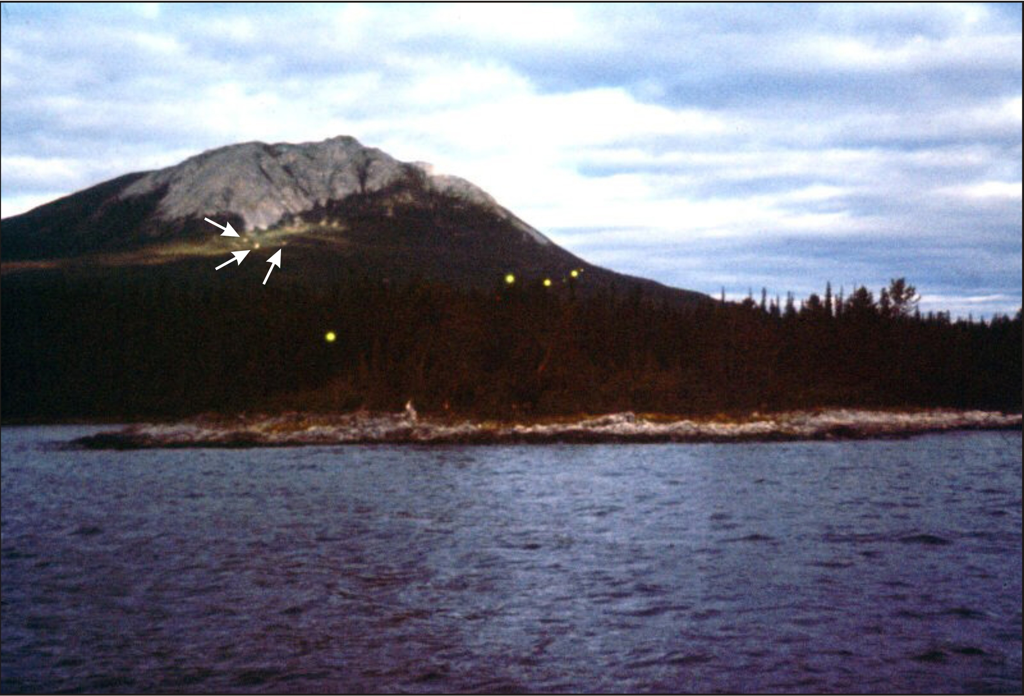
▲Figure S2. Photograph of earthquake lights observed along the western shore of Tagish Lake, southern Yukon. A total of seven yellow-colored orbs can be seen, the closest being at about 500 meters away from the two witnesses. The three farthest orbs are shown by the white arrows. The orbs have a diameter of approximately one meter. For original color photo, see website (Jasek, 1998). Photo credit: Jim Conacher (used with permission).
Acapulco-Ometepec earthquake, 1907 April 15, 00h14: (19) The Ms 8.0 Acapulco-Ometepec earthquake occurred along the Pacific coast of Mexico, approximately 75 km to the SSE of Acapulco (Nature, 1907; Marvin, 1907; Nishenko and Singh, 1987; Ortiz et al., 2000). The length of the rupture along the Pacific coast was estimated at 110-140 km (Nishenko and Singh, 1987), and the earthquake was felt up to 800 km away from the epicentral area (Nature, 1907). This coastal earthquake is related to subduction of the Cocos Plate under Central America (Ortiz et al., 2000).
Possible EQL were observed at sea at the time of the earthquake. Here is a description reported by Fuller (1912): “Bearing on the origin of the flashes or glows, the observations of several of the captains of ocean liners in the Tropics at the time of the recent severe disturbance in Mexico (1907) are of significance. They reported that on the night on which they afterwards learned that the earthquake had occurred, strong glows in the sky, resembling the auroras of northern latitudes, were seen. As these were not reported farther north the view suggests itself that they were due to magnetic disturbances…. ”.
Central America
Guadeloupe, Pointe-à-Pitre earthquake, 1843 February 8, 10h40: (20)
The M 7.5 Guadeloupe, Pointe-à-Pitre earthquake took place at sea in the Lesser Antilles area, about 50 km to the east of Antigua and 110 km to the NNE of Pointe-à-Pitre, Guadeloupe (SisFrance, 2013). The Lesser Antilles arc results from the ongoing subduction of the American plates under the Caribbean Plate (Feuillet et al., 2001; Terrier and Bes-de-Berc, 2007). The epicenter of the Guadeloupe, Pointe-à-Pitre earthquake was situated along this subduction zone, about 150 km to the west of the subduction front. The area of Pointe-à-Pitre is located along the northern rim of the Marie-Galante Graben, a 30 km wide by 110 km long, WNW-ESE oriented structure that extends perpendicular to the Antilles arc. This attests to an episode of approximately north-south, recent crustal extension in the area (Feuillet et al., 2001; Terrier and Bes-de-Berc, 2007).
At the time of the earthquake, some EQL were observed in the city of Pointe-à-Pitre, Guadeloupe. M. Hippolyte Chocque, a watchmaker living in Pointe-à-Pitre, described in the following terms the particular luminosities he witnessed at the time of the earthquake: “… The weather was remarkably nice…; the atmosphere, charged with a few clouds in the morning, became perfectly pure half an hour before the event. A phenomenon for which I was the only witness in my locality, and that, from the recollection of several people, repeted itself in other places, is that, at the time the floor fell from under my feet, during my fall along with the collapsing house, I saw a bluish flame come out of the earth and rise about 2.5 m above the ground; it’s width could have been 0.30 m at it’s base” (Arago, 1859). According to Galli (1910), no volcanic activity occurred in the area during the year of 1843, as well as the following year, the last activity dating back to 1837-1838.
South America
Cumana earthquake, 1797 December 14, 18h30: (21)
The MMI IX Cumana, Venezuela, earthquake was estimated to have been located slightly east of the city of Cumana (Audemard, 2007). More than 80 % of the city was completely destroyed. The area is traversed by the El Pilar fault, an E-W oriented, right-lateral strike-slip fault that is part of a large-scale fault system extending for some 800 km in length and 100 km in width in northern Venezuela (González et al., 2004).
The following was reported by Von Humbolt and Bonpland (1814): “At Cumana, half an hour before the catastrophy of December 14, 1797, a strong smell of sulphur was perceived near the hill of St. Francis convent; on the same spot, a subterraneous noise, which seemed to proceed from the SE, was heard the loudest. At the same time, flames appeared on the banks of the Manzanares River, near the hospice of the Capucins (Hospicio de Los Capuchinos) in Cumana”. Note that all these locations are situated along the El Pilar fault.
Gulf of Paria earthquake, 1766 October 21, 04h45: (22)
The Ms 7.5 Gulf of Paria earthquake occurred at sea in the Gulf of Paria, to the west of Trinidad. The location of the epicenter, which was approximated from isoseismals, was situated about 200-250 km to the east of the Cumana earthquake. It represents the most extensive historic earthquake ever felt in Venezuela (Audemard, 2007).
As reported by Audemard (2007), flames were observed in the vicinity of the Gulf of Cariaco, about 175 km to the west of the epicenter and along the El Pilar fault.
Pereiro earthquakes, from January to end of March 1968: (23)
The mb 3.9 to 4.5 Pereiro earthquake series occurred about 225 km to the south of the coastal city of Fortaleza, in eastern Brazil. A total of 5 seismic events were recorded between January and March of 1968 (Torres, 1994). The area of Pereiro is located approximately at the point of intersection of two regional scale structures, which are the Jaguaribe fault zone and the Carini-Potiguar Rift Zone. The former structure is a NE-SW to NNE-SSW oriented shear zone that extends for about 400 km inland from the Atlantic coast. This strike-slip fault passes about 10 km to the west of the city of Pereiro. The Carini-Potiguar Rift Zone is a 500 km long intracratonic rift that consists of a series of discontinuous, NE-SW to ENE-WSW oriented basins and half-grabens (Peulvast et al., 2006). This extensional structure is one of several Early Cretaceous rift basins found in northeast Brazil, which are interpreted to be associated with the opening of the South Atlantic (De Matos, 1992).
Here are excerpts from a letter by Creighton (1968), former British diplomat, to Flying Saucer Review:
“Bluish green, fiery balls were seen flying in all directions overhead. Few among the 30 000 Pereiro inhabitants have not seen them. The witnesses repeatedly describe them as being like “big automobile headlights” that sometimes stay without movement, sometimes move up and down in the sky, and sometimes shoot about in straight line. Their luminosity is strong and they are noiseless…. It had been established that their appearance always precedes the tremors by a few hours”.
Pisco, Peru earthquake, 2007 August 15, 18h41; EQL descriptions only : (24)
Here are two examples of observed luminosities given by Ocola and Torres (2007):
- At Playa Yumaque (about 70 km SE of the epicenter), at around 18h35, a fisherman entered the water to throw his nets. Everything was obscure. A few minutes later, everything lit up in a medium violet coloration. He secured his nets, and then came the shocks. The sea became agitated around him. Moments later, the sky regained its darkness and the sea became calm again. Then, another shock happened and again, everything lit up as in full daytime. Note that Playa Yumaque is located on the southern side of the Paracas Peninsula, and is thus approximately 10 km (or less) to the south of the major Pisco-Juruá Fault.
- At San Clemente (about 60 km SE of the epicenter), a witness reported: “a few seconds after the start of the tremors (18h41), there was a luminosity in the distance, over the sea and towards the Bay of Paracas (i.e. towards the SSW). This reddish luminosity lasted for 1-2 minutes, until the end of the second shock”. The Bay of Paracas coincides with the location of the second rupture zone associated with the Pisco, Peru earthquake (Ocola and Torres, 2007; Sladen et al., 2010). Furthermore, it is located at the southwestern termination of the SW-NE oriented, continental scale Pisco-Juruá Fault.
Mendoza earthquake, 1861 March 20, 20h46: (25)
The M 7.0 Mendoza earthquake was located about 10 km to the SW of Mendoza. It was the most destructive earthquake ever to hit Argentina. In Mendoza, it completely destroyed the city and was responsible for the death of 6,000 people out of a population of 18,000 (INPRES, 2013). The epicenter was located within the Cuyo Basin, a 600 km long by 50-100 km wide, NW-SE rift structure formed in Triassic to early Jurassic time during the break-up of the supercontinent Pangea (Ramos and Kay, 1991).
In the city of Mendoza, during the nights of March 20 and 21 when violent tremors took place, a person recalls having seen “fire balls” rising up from the base of the tree under which she was lying down. Each of the incandescent globes was accompanied by a tremor. Other persons have reported to have seen during the day a fog-like phenomenon at the very same place (Perrey, 1863; Galli, 1910).
Santiago earthquake, 1851 April 2, 06h48 : (26)
The Ms 7.1 Santiago earthquake occurred approximately 80 km to the WNW of Santiago and 35 km to the SSE of the coastal city of Valparaiso (DGF, 2013). As reported by Thomas and Baldwin (1856), the earthquake was severe, and was felt 60 km out at sea, off the mouth of Maypu River. The epicenter was located about 100 km to the south of the Juan Fernández Ridge, a hot spot trace that leads, further west in the Pacific, to the Juan Fernández mantle plume (Schissel and Smail, 2001).
This from Gilliss (1856), and reported by Corliss (2001): “… Not far from 9 o’clock on April 1st, there was a vivid, quick flash of lightning to the NNE, so intense the brightness as to illuminate within the observatory where I had been at work some hours. I was startled by the sudden brilliancy, and listened for close-following thunder, but no sound came neither was the flash repeated, nor was the smallest speck of cloud even about the horizon in that direction”. Note that the observatory was situated on Santa Lucia Hill, which is located in downtown Santiago. The area of Santiago is contained within the interpreted Central Valley Graben, a N-S oriented, 20 km wide by over 120 km long paleorift structure that is bounded by two major fault zones, namely the Los Angeles fault zone (western margin) and the Pocuro Fault (eastern margin) (Carter and Aguirre, 1965). This paleorift structure is referred by Farías et al. (2010) as the Central Depression or Abanico Basin, whose marginal normal faults were later reactivated as thrust faults. Note that the above mentionned luminosities were observed in the general direction of the Pocuro Fault.
Valdivia earthquake, 1960 May 22, 14h11 : (27)
The Mw 9.5 Valdivia (or Great Chilean) earthquake of 1960 is to this date the most powerful earthquake ever recorded (Melnick et al., 2006, 2008). Its resulting tsunami affected a large part of the Pacific coast, including Chile, Australia, New Zealand, Japan, Hawaii and Alaska. This seismic event is referred as a megathrust earthquake, having ruptured nearly 1000 km of the Nazca-South America plate boundary. Rupturing started at 38.2oS latitude, about 175 km to the NNE of Valdivia, and propagated southward to the Nazca-Antarctic-South America triple plate junction, located at about 46oS. This 1000 km long rupture segment is coincident with the extent of the Liquiñe-Ofqui fault zone, a NNE-SSW oriented, major dextral strike-slip structure that marks the eastern margin of the Chiloé microplate (Melnick et al., 2008, 2009). The hypocenter of the Valdivia earthquake, along with those of the other related earthquakes that occurred in the following months and years, are interpreted to have been located along or adjacent to the NW-SE oriented Lanalhue strike-slip fault zone, a steeply NE-dipping, long-lived crustal-scale structure that extends for about 200 km from the Liquiñe-Ofqui fault zone, where it branches off, up to Arauco Peninsula (Yuan et al., 2006; Melnick et al., 2008, 2009). The Lanalhue fault is interpeted to have controlled initiation and propagation of Valdivia 1960-type megathrust ruptures (Melnick et al., 2009).
This excerpt is from Saint-Amand (1962), and reported by Corliss (2001): “Several people reported luminous phenomena associated with this earthquake. The most interesting reports come from the Arauco Peninsula, where people in the city of Canete saw a luminous glow in the air associated with the stronger aftershocks. The phenomenon was described by a pilot, who, with three passengers, was trying to sleep in his plane .... The light was described as coming from the air, beginning abruptly and rising to a fairly constant level in less than one second. It continued for perhaps 40-50 seconds, dying out more slowly, with a decay time of a few seconds. It was seen only during the stronger aftershocks. The effect seemed to be the brightest at the horizon, to the south and east. The sky was quite clear. There was no electric power available on the peninsula which could have caused the phenomena, all the power having been shut off because of the earthquake”. Note that Arauco Peninsula and Arauco Bay (just to the north) are underlain by the Arauco Basin, a fault bounded paleorift structure that was undergoing extension between the Late Cretaceous and early Pliocene (Melnick et al., 2006). Apart from the observed luminous phenomena, an unusual radio emission was detected on several widely separated radio astronomy receivers in the northern hemisphere on May 16, 1960, five days before the earthquake (Warwick et al., 1982).
Europe (see Table 2 and Figure 2 of the paper)
Penzance, England earthquake - 1996 November 10, 09h28 : (1)
The Mw 3.8 Penzance earthquake occurred near the western tip of the Cornwall Peninsula. The area has undergone at least two episodes of rifting during the Phanerozoic : 1) in the Devonian (pre-Variscan), NE-SW crustal extension led to the formation of the Lizard Complex-Gramscatho pull-apart basin, which was associated with the emplacement of the mafic-ultramafic Lizard Complex (Cook et al., 2002); and 2) following NW-oriented thrusting during the Variscan Orogeny (Waters and Davies, 2006), Permo-Triassic extension led to the formation of the Plymouth Bay Basin (Peacock, 2004), whose northern limit is located in the general area of the Penzance earthquake. The rhomb-shaped morphology of the Plymouth Basin led Ruffell et al. (1995) to suggest that it likely formed during NW-SE extension in a pull-apart within a strike-slip fault system.
Seven luminous phenomena were reported within 45 km from the epicenter. The luminous phenomena were observed more or less along an E-W orientation that parallels the northern edge of the Plymouth Bay Basin. One week before the main shock, an unusual white light was seen at 5 pm from a road near Pendeen, located on the SW coast of the Cornwall Peninsula. Five days before the earthquake, an orange-red “block of light” appeared above the Mawnan Smith church, located on the north bank of the Helford River. This was seen from Gillian, about 2 km south of this location. Four days before the earthquake, a full-moon-like sphere of light was seen above the same church for some 10-12 s (real moon was at phase 0.19, i.e., a thin crescent). Sunday night, about 14 hours after the mainshock, frequent very bright flashes in the sky were observed at St-Yves, on the SW coast of the Cornwall Peninsula, which was followed 5 minutes later by a passing noiseless orange ball of light which materialized to the east, picking up speed moving west along the coast. Note that St-Yves is located approximately over a NW-SE oriented fault that extends towards the southeastern part of the Lizard Peninsula. On Monday the 11th, around 3 am, a 20 s brilliant “flash” of light was seen over Falmouth Bay, while at Perranar-Worthal, just north of Penryn, a man reported unusual lights above the village (British Geological Survey, 1996; Devereux, 1997; The West Briton & Royal Cornwall Gazette, 1996).
Helston, England earthquakes (twin event, 5 s apart) - 1966 July 23, 02h50 : (2)
The Mw 3.6 Helston earthquake (Musson, 1989, 1994) was located approximately 5 km to the NW of the northern edge of the Lizard Complex-Gramscatho pull-apart basin (Cook et al., 2002), which also coincides approximately with the northern edge of the Permo-Triassic Plymouth Bay Basin.
Three EQL were seen within 25 km from the epicenter. On the SE coast, a flash just prior to the earthquake was noted by several people at Falmouth. From Mullion, a red glare was seen in the sky in the Coverack area, on the SE coast of the Lizard Peninsula. A bright light in the sky was seen by a few people at St-Yves on the SW coast (Musson, 1989, 1994). Note that Coverack and St-Yves are located at both ends of a NW-SE oriented, interpreted Cenozoic fault that is part of a regional fault distribution pattern observed in southwestern England.
Iclon, France earthquake, Normandy - 1769 December 01, 19h35 : (3)
The Iclon earthquake occurred in Normandy, France, along the southeastern coast of the English Channel. Its intensity was evaluated at VI-VII on the Medvedev-Sponheuer-Karnik (MSK) scale (SisFrance, 2013). The earthquake took place along the southeastern edge of the English Channel Basin and adjacent to an extensive NW-SE oriented lineament. This structure, which corresponds to the Pays de Bray Fault, extends for over 500 km towards the ESE, reaching the southern part of the Upper Rhine Graben (Wilson and Patterson, 2001; Wilson and Downes, 2006).
Two different observations of EQL were reported from the vicinity of the Iclon earthquake. At Elbeuf (15 km south of Rouen), the Seine River seemed to boil up with a bellowing noise, and a multitude of shooting stars with brilliant trains were seen. At Houlme (northern part of Rouen), a bright light was observed in the sky (Mallet, 1854). Note that these two sites coincide approximately with the location of the Seine Fault, which follows the river of the same name. This fault is parallel to the Pays de Bray Fault and runs about 60 km to the south of it (Bourdier and Lautridou, 1974).
Market Rasen, England earthquake - 2008 February 27, 00h56 : (4)
The Mw 4.4 Market Rasen (Lincolnshire) earthquake (Musson, 2008) was located 4 km to the north of Market Rasen, approximately along the NW-SE oriented, fault-bounded margin between the Askern Spital High and the Humber Basin half-graben. This was the largest earthquake in the UK since the 5.4 M Lleyn Peninsula earthquake (British Geological Survey, 2013), which occurred in North Wales in July 1984 and gave rise to some “ufo” reports (Devereux, 1989).
Five EQL sightings were reported for this earthquake. The EQL locations were found to be aligned in a WSW-ENE direction, spread over a distance of nearly 100 km and passing approximately 15 km to the south of Market Rasen. A couple living in Tathwell reported seeing flashes of light as the earthquake rumbled across the country. The most striking event, seen at Louth about 25 km east of the epicenter, was a ball of light of a grape-fruit size seen crossing a ground floor bedroom during the mainshock. It went out like a light (Louth Leader newspaper, 2008a, 2008b).
Roermond, Netherlands earthquake - 1992 April 13 : (5)
The Mw 5.3 Roermond earthquake (Camelbeeck and Meghraoui, 1996) was located along the Peel Fault, which defines the NE margin of the Roer Valley Graben. This rift measures 25-30 km in width, and is the main structure of the Lower Rhine Graben, which is part of the Cenozoic Rift System of western Europe (Camelbeeck and Meghraoui, 1996; van Bergen and Sissingh, 2007).
EQL were observed about 70 km to the north of the earthquake, as reported to one of the authors by the witness Mr. E. van Ulft in 2006. From an elevated hill near Dieren, a curtain-like light coming from the direction of Millingen (south of Dieren) was sighted four days after the main shock. The light followed a parallel course with the Waal River towards the west. The man estimated its speed at about 200 km/h. The light disappeared at the horizon near Arnhem. The curtain of light was several km long and appeared to be clear of the ground. The witness was situated about 18 km north of the Waal River, which runs towards the east and then turns to the southeast into the Venlo Graben, which is part of the Lower Rhine Graben. The sky was clear.
Aachen (Aix), Germany earthquake - 1755 December 27, ~ 00h30 : (6)
The Aachen (Aix) earthquake had an estimated intensity of MSK VI-VII (Alexandre, 2013). The epicenter was located near the southeastern end of the Feldbiss Fault that marks the SW limit of the Roer Valley Graben. The earthquake occurred approximately 40 km to the south of the Roermond earthquake.
In the Lower Rhine area, numerous seismic shocks were felt. At Rocroi (Meuse valley), 145 km to the SW of the epicenter, as well as in other places, these shocks were preceded by a dull noise. The sky also appeared as if it was on fire (Mallet, 1854).
Düren, Germany earthquakes - 1756 February 18 until April : (7)
The Düren earthquake series occurred a mere 2 months after the Aachen earthquake (Alexandre, 2013). The Düren area is located 30 km to the east of Aachen and near the Rurrand Fault, which defines the northeastern margin of the Roer Valley Graben.
In Cologne, Liège and Namur, located between 40 and 110 km from the epicenter, the ground shook just about every day from February 18 until the month of April. The most violent shocks were accompanied by large lightning sparks or luminous flashes (Mallet, 1854).
Karlsruhe-Rastatt, Germany earthquake - 1737 May 21, 21h00 : (8)
The Karlsruhe-Rastatt earthquake was part of a series of earthquakes that occurred along the eastern faulted margin of the central part of the Upper Rhine Graben. Its intensity was evaluated at MSK V (SisFrance, 2013). The Upper Rhine Graben is a NNE-SSW oriented, 350 km long by 40 km wide graben structure that extends from central Germany southward to near the northwestern border of Switzerland. It is the most prevalent of several dominantly NNE oriented, regional scale grabens that extend over a distance of some 1100 km from the North Sea coast to the Mediterranean (Dèzes et al., 2004). These rift-related sedimentary basins formed in the foreland of the Alpine Orogen, and are interpreted as being likely related to crustal extension caused by large-scale mantle upwellings or plumes (Hoernle et al., 1995; Goes et al., 1999; Wilson and Patterson, 2001; Dèzes et al., 2004; Harangi et al., 2006; Wilson and Downes, 2006; Lustrino and Wilson, 2007). Diapiric upwelling of mantle material also led to domal uplift of Variscan basement massifs (e.g. Massif Central, Armorican Massif, Rhenish Massif and Bohemian Massif) and to widespread Tertiary-Quaternary alkalic volcanism within western and central Europe (Wilson and Patterson, 2001). Evidence of volcanic activity is present in both the northern (e.g. Vogelsberg) and southern parts (e.g. Kaiserstuhl, Urach and Hegau) of the Upper Rhine Graben.
At Karlsruhe, at an unknown time relative to the earthquake of May 21, the mountains were covered with thick mist, through which traces of a dim light could be perceived. Three days prior to the earthquake, globes of fire were seen in the air on the side of Landau, 25 km to the NW of the epicenter and within the central part of the Upper Rhine Graben. These lights had also been seen there three weeks before (Mallet, 1853).
Giromagny, France earthquake - 1843 December 21, 23h00 : (9)
The Mw 3.9 Giromagny earthquake happened at the southwestern extremity of the Upper Rhine Graben, at the southern limit of the Vosges Mountains (ECOS, 2013). The Upper Rhine Graben is a NNE-SSW oriented, 350 km long by 40 km wide graben structure that extends from central Germany southward to near the northwestern border of Switzerland. It is the most prevalent of several dominantly NNE oriented, regional scale grabens that extend over a distance of some 1100 km from the North Sea coast to the Mediterranean (Dèzes et al., 2004). These rift-related sedimentary basins formed in the foreland of the Alpine Orogen, and are interpreted as being likely related to crustal extension caused by large-scale mantle upwellings or plumes (Hoernle et al., 1995; Goes et al., 1999; Wilson and Patterson, 2001; Dèzes et al., 2004; Harangi et al., 2006; Wilson and Downes, 2006; Lustrino and Wilson, 2007).
EQL were observed about 75 km from the epicenter. At Rougegoutte, a small village next to Giromagny, the seismic shock was preceded by such a bright light that “the light made by the candles was dimmed”. At Belford, 15 km to the south of Giromagny, although no shock was felt, a glow of light resembling lightning was observed. At Delémont, 50 km to the SW of the epicenter, two seismic detonations were each accompanied, within 2-3 seconds, by a light “as bright as the sun”. At Fribourg, 75 km to the ENE of Giromagny and within the Upper Rhine Graben, the same bright light was observed, which was described as being so violent that for people standing on the surrounding hills, the entire city appeared to have been on fire (Montandon, 1948).
Remiremont, France earthquakes - 1682 May 13, 02h30 (also May 2, 7, and 12) : (10)
A series of four earthquakes took place in May 1682 in the area surrounding Remiremont, the most significant being the last event, MSK VIII (SisFrance, 2013). The seismic area is located on the southwestern flank of the Vosges Mountains, near an ENE-WSW trending transform zone linking the Bresse Graben to the Upper Rhine Graben (Mekkawi et al., 2003; Madritsch et al., 2009).
EQL were observed within 200 km south of the epicenter. In Remiremont and Plombière (about 40 km west of the Rhine Graben), flames were observed rising from the ground without recognition of their source. They dispersed a very unpleasant odor (Galli, 1910; Bourlot, 1866). All the letters written in Lyon, Geneva and elsewhere in Switzerland mention “flames” that appeared 4 days prior to this “movement” on a Jura mountain next to Geneva (Montandon, 1948).
Ebingen, Germany earthquake - 1911 November 16, 22h25; EQL descriptions only : (11)
Here are a few examples of light sightings described by von Schmidt and Mack (1912):
- A pastor who was in the neighbourhood of Reutlingen at the time of the earthquake, wrote: “I was in the main street at the station (at about 22h30) when I suddenly found a light phenomenon about 5 paces from me. It came not from above, but evidently out of the earth, and lifted itself vertically from the ground, to the height of an adult. The light was thicker in the middle, thinner below and above. I heard an underground noise, like the rolling of a heavily loaded wagon or the collapse of a mass of stone onto the ground”. Very soon afterwards, the light disappeared.
- The wife of mechanic Kiessling in Ebingen wrote: “As soon as we glanced in the air, several fiery balls appeared at two thirds the height of a person, and immediately spread out and appeared to break apart with a noise like thunder. The milkmaid from Truchtelfingen was coming behind us with her wagon, which skidded to the side of the street, and we saw a dense fire rise out of the ground in front of it, which quickly became as big as her and took the shape of a big disk, which was lit in all colors like a rainbow”.
- A teacher in Tailfingen (5 km north of Ebingen) stated: “Bluish stripes, bands and sheaves rose from the earth and, at the height of the valley walls (i.e. Hohenzollern Graben), united in a ball-like shape and with frightful sputtering, hissing and cracking fell apart in all directions”.
- The wife of a signalman at Station 60 near Ebingen, said: “At the onset of the earthquake I saw in an open area near to the signal house three luminous phenomena like lightning, which moved horizontally on the ground like snakes”.
Belley, France earthquake - 1823 December 13, 03h00 : (12)
The Belley (or Bugey) earthquake, MSK V-VI (SisFrance, 2013), was located approximately 30 km to the east of the Bresse Graben, near its southeastern extremity. The Bresse Graben is a N-S trending rift structure that is part of the Cenozoic rift event of western and central Europe (Sissingh, 1998).
At the time of the shock, an inhabitant of Bénonces, located 20 km NW of the epicenter and near the eastern edge of the Bresse Graben, reported that the sky appeared as being all on fire an instant after the “explosion”, although he saw no meteor (Mallet, 1855).
Saint-Geniez d’Olt, France earthquake - 1876 December 19, 05h06 : (13)
The Saint-Geniez d’Olt earthquake, MSK IV-V (SisFrance, 2013), occurred in the southern part of the Massif Central, near WNW-oriented faults that spatially coincide with the southern limit of the Limagne Graben.
In Sévérac-le-Château, located 12 km to the south of the epicenter, during the main shock, several people observed towards the NW a reddish glow of light quite similar to a lightning bolt, but less bright (Bulletin Hebdomadaire de l’Association Scientifique de France, 1877; Galli, 1910).
Argelès-Gazost, France earthquake - 2006 November 17, 19h19 : (14)
The Mw 4.5 Argelès-Gazost earthquake (Cara et al., 2007) was located just slightly to the south of the North Pyrenean Fault, which marks the northern limit of the Pyrenean paleorift (Vergés and Garcia-Senz, 2001).
About 23h30, two men in a car saw a vertically elongated, white luminous mass rapidly crossing the road about two meters above the ground. They do not remember the exact date, but they know it was near the day of the earthquake (Moraine, pers. comm., 2006). They were driving on National Road N-117 between Ossun and Tournay. This section of the road is about 25 km north of the epicenter at the northwestern end of the mapped Adour Fault, near Tarbes (Mattauer and Henry, 1974; Souriau et al., 2001). It is noteworthy to mention that a M 3.1 aftershock occurred at 23h17 the day after the mainshock (Cara et al., 2007).
Bagnères-de-Bigorre, France earthquake - 1873 November 26, 04h33 : (15)
The Bagnères-de-Bigorre earthquake, MSK VII (SisFrance, 2013), occurred approximately 30 km to the ENE of the Argelès-Gazost earthquake. The location of the earthquake corresponds very closely to the intersection between the WNW-ESE trending North Pyrenean Fault and the NW-SE oriented Adour Fault (Mattauer and Henry, 1974).
At the time of the shock, the sky promptly became coloured with a reddish glow that shortly disappeared, leaving again the sky perfectly clear. On the road to Tarbes (now road N-117, mentioned previously), about 30 km north of the epicenter, a woman riding a horse towards Pau suddenly observed a glow of light similar to lightning. Her horse reared up and refused to move forward (Piché, 1873; SisFrance, 2013).
Orihuela del Tremedal, Spain earthquake - 1848 October 3, 15h30 : (16)
The Orihuela del Tremedal earthquake, MSK VI-VII (IGN, 2013), occurred approximately 10 km to the WNW of the city of Orihuela del Tremedal, near the western margin of the Jiloca Graben. This structure is oriented NNW-SSE, and is related to the rifting of the Valencia Trough (Fontboté et al, 1990; Arlegui et al., 2006; Rubio and Simón, 2006).
At Monterde del Abbaracin, approximately 20 km to the SE of the epicenter, witnesses testified seeing sparks spraying out of the city walls, as if there were electrical discharges (Galli, 1910).
Chamonix, France earthquake - 1817 March 11, 21h25 : (17)
The Mw 4.8 Chamonix earthquake (ECOS, 2013) was located approximately along the Rhône-Simplon Fault. In the area, this fault is oriented SSW-NNE and is subjected to thrust deformation, likely along a reactivated normal fault of the Valaisan paleorift, which formed during the break-up of Pangea and creation of the Tethys ocean in the Mesozoic (Coward and Dietrich, 1989). Due to the strong curvature of the western Alps, reactivation movements along the Rhône-Simplon Fault are interpreted as having been horizontal (i.e. strike-slip faulting) in southern Switzerland, and vertical (i.e. thrust faulting) in eastern France (Schmid and Kissling, 2000).
During the earthquake, between 9 and 10 pm, a lightning ray moving downwards was seen above Mont Blanc, which is adjacent and just to the east of the Rhône-Simplon Fault (Montandon, 1948).
Sierre, Switzerland earthquake - 1946 January 25, 18h32 : (18)
The Mw 6.1 Sierre earthquake (ECOS, 2013) occurred directly within the Rhône Valley, which coincides approximately with the position of the Rhône-Simplon Fault. This regional scale structure appears to correspond to the northern limit of the Valaisan paleorift, which formed during the break-up of Pangea and inception of the Tethys Ocean. In this area of southern Switzerland, the E-W oriented Rhône-Simplon Fault is interpreted to be undergoing horizontal strike-slip deformation (Schmid and Kissling, 2000).
In Fleurier, 90 km NW of the epicenter, an intense light lasting about 5 seconds was observed in the sky shortly before 18h00. Several seconds prior to the first shock, a number of people from Ormonts-Dessus (about 30 km to the WNW of the epicenter) witnessed a “meteor” moving East towards les Diablerets, which looked like “an immense rotating sun” having a fiery red central part surrounded by a shower of white sparks. Flames were also seen escaping from the ground. In Brig, 35 km east of the epicenter (i.e. along the Rhone-Simplon Fault), a witness who was outside at the time of the main shock explained that “a detonation was heard and then from the roof of the houses, burst out a bright white luminosity accompanied by a strange crackling sound in the air that lasted about 5 seconds” (Montandon, 1948).
Brig, Switzerland earthquake - 1755 December 9, 14h30 : (19)
The Mw 6.1 Brig earthquake (ECOS, 2013) occurred about 35 km to the ESE of the Sierre earthquake. The earthquake was also located within the Rhône Valley, which approximately corresponds to the trace of the Rhône-Simplon Fault.
During the aftershock of March 3, 1756, at about 7 pm, an “igneous meteor” was observed in the sky from Berne (90 km to the NW of Brig), Vevey (90 km to the WNW of Brig) and Aigle (75 km to the W of Brig). Two days later, another aftershock was felt in Brig, accompanied again by the observation of an “incandescent globe” in Aigle (Montandon, 1948).
Imperia, Italy earthquakes - 1887 February 23, 06h22 (main shock), 06h30 and 08h50 : (20)
The Mw 6.29 Imperia earthquake (Boschi et al, 1997), represents the greatest seismic event to have occurred along the western coast of Liguria in the last thousand years (Ferrari, 1991). The epicenter was located approximately 20 km to the SE of the coast, along an offshore NE-SW oriented normal fault (Ferrari, 1991; Eva and Rabinovich, 1997). This fault is part of a system of coast-parallel active normal faults structured into grabens and half-grabens, which formed through back arc extension that developed behind the Apulian subduction zone (Augliera et al., 1994; Rollet et al., 2002). Rifting was also associated with significant volcanism in the basin and on its southern margin.
The EQL observations came from 10 localities all situated along the shore of the Mediterranean, except for the city of Acqui, which is 40 km inland and 90 km to the NNE of the epicenter. Most of the reports talk about light flashes just before the shocks, but in one case, on each of the three mornings before the seismic sequence. This, from Diano Marina : “Just before sunrise a zigzag light was seen at sea towards the E-ESE horizon. The light had a bluish tint. Moments before the main shock, residents of Loano (35 km NE of Imperia) observed a red light in the sky that looked like a flame” (Tributsch, 1982).
In association with this earthquake, electrical effects at telegraph stations were observed in Cannes (90 km SW of the epicenter) and in Nice (75 km SW of the epicenter) as well as in other localities adjacent to Imperia (e.g. Diano Marina, Oneglia; Tributsch, 1982). In Nice, for example, at the moment of the 3rd shock at 08h50 LT on February 23, an operator received a strong electric shock which threw him backwards in his chair and left him unable to move for a few minutes. Just before this incident, the telegraph apparatus was creaking and jerking (Poirier et al, 2008). Furthermore, Taramelli and Mercalli (1888) gathered reports of unusual animal behaviour from over 130 communities located up to 150 km from the epicenter. About 20 % of these observations came several hours (i.e. 3-12 hrs) prior to the earthquake.
Reggiano (Parma), Italy earthquake - 1832 March 13 to end of March : (21)
The Mw 5.59 Reggiano (Parma) earthquake (Boschi et al., 1997) occurred between the cities of Reggiano and Parma, which are about 25 km apart. The epicenter was located along an important thrust zone associated with the northeastern margin of the NW-SE striking Apennines mountain chain, which in this area is undergoing tectonic compression. The Apennines initially formed as a NW-SE striking orogenic thrust belt, but starting about 3 Ma ago until present, significant crustal extension has been taking place, with normal faults being parallel to the older and often reactivated thrust faults. The normal faults typically occur in en-echelon systems and form half-grabens or grabens (D’Agostino et al., 1998, 2001). Extension has been interpreted as being caused by either isostatic rebound, subducted slab retreat or convective mantle upwelling possibly related to mantle plume activity (Lavecchia and Stoppa, 1996; D’Agostino et al., 2001; Roberts and Michetti, 2004; Lavecchia and Creati, 2006; Papanikolaou and Roberts, 2007; Bell et al., 2006). The latter interpretation is supported by abundant volcanic activity throughout most of Italy that possesses mantle plume rather than subduction related isotopic and geochemical signature (Bell et al., 2006). Although the Reggiano area is located approximately 60 km to the NE of the zone where crustal extension is presently occurring, an important SW-NE to WSW-ENE oriented lineament, called the La Spezia-Reggio Emilia-Concordia Line, extends for over 100 km from the margin of the Ligurian Sea to the thrust zone in the Reggiano area (Fazzini and Gelmini, 1982; Di Giovambattista and Tyupkin, 1999; Elter et al., 2009). This lineament, more or less orthogonal to and cutting the Apennines mountain chain, is interpreted as a sinistral strike-slip shear zone (Fazzini and Gelmini, 1982). It may represent a reactivated transform fault formed during rifting/drifting of the Ligurian Tethys proto-ocean.
On March 13, 1832, at Modena (35 km SE of the epicenter), a strong shock at around 03h30 was accompanied by a vivid flash. On the early morning of March 14, a moderate aftershock felt at Parma was also accompanied by a flash (Galli, 1910).
Calestano, Italy earthquake - 1898 March 4, 10h07 : (22)
The Mw 5.07 Calestano earthquake occurred about 18 km to the SE of Calestano and 28 km to the SW of the Reggiano (Parma) earthquake (Castelli et al., 1996). The epicenter was located approximately 7 km to the NW of the Spezia-Reggio Emilia-Concordia Line, a regional scale lineament that bisects the Apennines mountain chain (Fazzini and Gelmini, 1982; Di Giovambattista and Tyupkin, 1999).
On March 4, 1898, at 22h07, a strong shock was felt by all the inhabitants of the Emilia Province and surrounding areas. From professor Pio Benassi (Galli, 1910) : “From San Michele di Tiorre to Torrechiara (10-15 km north of the epicenter), several people standing outside alleged to have seen a sudden flash of light similar to heat lightning along the horizon (…). Rather than hearing thunder that should have followed, they heard a rumble and felt themselves sway”. In Parma, this flash of light was also seen by a few people. For example, a few minutes after turning off his bedroom light, a librarian was surprised by an intense flash that lit his entire bedroom. Immediately afterward, he was tossed violently in his bed, surprised by the shock of an earthquake.
Bologna, Italy earthquakes - 1779 June to 1780 March : (23)
A series of earthquakes occurred during a period of about 9 months in 1779-1780 in the vicinity of Bologna. The main earthquake, Mw 5.0, occurred on June 4, 1779 and was located approximately 15 km to the SE of the city center (Boschi et al., 1997). The general area of Bologna is situated along the northern Apennines mountain front, where the crust is undergoing coeval shortening and extension (Picotti and Pazzaglia, 2008). In light of the coevolution of crustal shortening and extension in the area, it remains uncertain whether the main earthquake was located or not along an extensional fault.
Starting on June 7, 1779, during the episode of strongest quakes, a great quantity of fire balls were seen at San Michele, in the Bosco hills, 1.2 km to the south of the city center (i.e. just outside the city walls). The fire balls were seen rising from the mountain into the air with great force; there were so many that it looked like a “rain of fire”. Some of them reached a diameter of about 80 cm. They sometimes produced a hissing sound, at other times they disappeared with a detonation. On January 16, 1780, at 06h30 (i.e. before sunrise), a man saw from his window a one-meter wide ball of light rising from the ground to the height of his house. The large luminous ball was whitish with numerous pointy edges. The whole observation lasted about 16 to 18 s. In 1779, tongues of flame were also seen issuing from the ground at about a one foot distance from each other and rising to a height of about 8 feet, where they coalesced to form one great flame, and soon after disappeared with a detonation (Galli, 1910; Montandon, 1948).
Camerino, Italy earthquake - 1799 July 28, ~ 03h00 : (24)
The Mw 5.93 Camerino earthquake of July 1799 occurred approximately 5 km to the east of the city of Camerino (Monachesi, 1987). The epicentral area is located between the northern Apennines NNW-SSE oriented structural front, to the east, and a series of orogen-parallel normal faults belonging to the Umbria fault system, to the west and south (Cello et al., 1997; Colletini et al., 2006).
The EQL were observed within 15 km of the epicenter. At Camerino, during the mainshock, flashes and streaks of light were seen in the air. At Matélica (15 km to the NNW of the epicenter), standing on a neighboring hill, an Augustine Father saw above the city a vertically elongated, multi-coloured luminous mass having the shape of an amphora. At Pallorito (circa San Severino, 10 km to the NE of the epicenter), a great ball of fire was seen drying out the leaves of a tree when passing close by. At Cessapalombo, located 12 km to the ESE of the epicenter, the tower of the church was surrounded by a ball of fire (Galli, 1910).
Camerino, Italy earthquake - 1873 March 12 : (25)
The Mw 5.88 Camerino earthquake of March 1873 took place approximately 15 km to the ESE of the city of Camerino (Monachesi, 1987), about 10 km to the SE of the 1799 Camerino earthquake. Both earthquakes are interpreted as being related to displacement along different normal faults.
From Pioraco, flames were seen escaping the ground along the flank of Monte Primo mountain, located about 20 km to the NW of the epicenter, and ceased a few minutes after the shocks. Note that the Monte Primo is located about 10 km to the NE of the Colfiorito Basin, where a system of active normal faults are responsible for the moderate to high seismicity observed in that area (Diaferia et al., 2008). Shortly after the earthquake, a bright reddish glow of short duration lit up the landscape. At San Ginesio, Camerino and Ascoli, at the time of the shock, people saw a “column of fire” and a light explosion in the Morello area, located 15 km to the east of the epicentral area. The column originated from the ground and spread itself into the sky (Galli, 1910).
Two other historic earthquakes associated with EQL were also documented from the Camerino area : 1) June 3, 1781, Mw 6.23; and 2) February 12, 1854, Mw 5.37 (Galli, 1910).
L’Aquila, Italy earthquake - 2009 April 06, 03h32; EQL descriptions only : (26)
Here are some EQL examples from Fidani (2010):
- A yellowish-orange ball of light was observed toward Mount Ocre at the beginning of March 2009. The light was first seen midway along the flank of the mountain, where it remained for a while and then suddenly moved up to the mountain top and disappeared behind it. Note that a normal fault passes along Mount Ocre.
- At 01h30, before the 03h32, April 6 main shock, a man, while standing in the darkness of his home near Pettino (about 4 km N of the epicenter), saw two white flashes reflecting on the kitchen furniture. The second flash was as intense as daylight brightness and lasted more than one second. Looking out at the window, he saw stars in the sky and heard no sound. Remembering an EQL summary he had read a few months earlier (and possibly taking into account the small shocks of March?), he decided to take his family to a safer structure. Further on, he also noticed an abnormal increase of air temperature outside compared to around 21h. Note that the village of Pettino is situated along the Pettino fault.
- While loading a truck near the village of Bazzano (about 8 km E of the epicenter), a man suddenly felt a hot wind and saw an unusual bright flaming-red glow masking the profile of Mount Bazzano. Immediately after, he heard a roar and felt the shock. Note that this village is situated along the Bazzano fault.
- In the historical city center of L’Aquila, small “flames” were seen coming out of the stone-paved Francesco Crispi Avenue. About 10 cm high, they were standing some centimeters above the street and lasted several seconds. These small “flames” were seen simultaneously seconds before the main shock of April 6. Other small “flames” were also sighted above cement or wooden utility poles in San Sisto, west of L’Aquila. Note that no burning traces were later found by the author or the witnesses on objects over which flames were sighted.
- At the tail end of the main shock and afterwards, a witness saw about ten brief small bolts of lightning in a serene sky just above the towns of Arischia and Cansatessa (5-10 km N of the epicenter). The bolts lasted about 10 seconds and were described as noiseless, thin greenish-blue electrical discharges that crossed each other. Arischia and Cansatessa are located near the Mount Marino fault and are about 5 km apart.
Aquilano, Italy earthquake - 1461 November 27, 22h00 : (27)
The Mw 6.46 Aquilano earthquake (Monachesi and Castelli, 1992) occurred approximately 20 km to the east of the main earthquake associated with the 2009 L’Aquila seismic event. These two earthquake events show clear similarities, as they were both associated with serious damage at L’Aquila and to smaller cities located to the SE, and were characterized by a long series of aftershocks, some of which were very strong (Rovida et al., 2009). Furthermore, the epicentre of the Aquilano earthquake was also located along the NW-SE oriented, SW dipping Paganica normal fault, near the eastern margin of the Aterno River Basin (EMERGEO Working Group, 2010).
The castellan of Rocca di Calascio, during the night and shortly before the earthquake, saw over Mount Camiscia (located 12 km to the NE of his observation point) a large “fire-like” luminosity that started to move towards L’Aquila, and based on its position, he estimated that the earthquake occurred at the time the luminosity reached the city. Other people also saw this gleam of light (Galli, 1910).
Molise (Isernia), Italy earthquake -1805 July 26, 21h00 : (28)
The Mw 6.57 Molise earthquake event occurred near the city of Bojano, in the Molise Region (Giuliani et al., 2009 ; Boschi et al., 1997). The earthquake was located along the NW-SE oriented North Matese Fault System, which borders the Bojano Basin to the southwest. The active normal faults which make up the North Matese Fault System were also responsible for a 1456 earthquake event as well as a 3 BC event (Giuliani et al., 2009).
The following description is from Galli (1910) : “There were people, standing on the hill of our PP. Camaldolesi Capuchin (80 km SW of the epicenter), who saw an underground lightning jumping out from the center of the (shallow) Lake Patria, which is located 20 km to the NW of Naples along the Tyrrhenian Sea; there were also people who saw a current of electric fire running on an iron hook to which was tied a rope holding two copper buckets used to collect water from the well”. Note that this 500 meter hill, which consists of a small volcanic cone, is part of the Naples area volcanic field (Calcaterra et al., 2007).
Again from Galli (1910) : “There were also those people staying at home, or in open country, that felt considerable heat to their legs, from a fiery draft of air coming out of the room floor, or out of soil. (…). In several places within this county appeared everywhere igneous meteors in the dusk of the evening, both days prior to as well as the same day of the earthquake. Some of these “meteors” traveled on the ground in a winding manner the time of an arquebus shot, and these events repeated themselves until the earthquake shock ended. At the time of the earthquake, the summit of Mount Frosolone (Matese Massif) appeared as if it was ablaze”. Note that the Matese Massif is located directly to the SW of the North Matese Fault System.
According to Poli (1806), the relation of the luminous phenomena with the earthquake is quite clear, but it is complicated by the fact that a meteor shower occurred at this period of time (i.e. Delta Aquarid, 28-29 July). Therefore, care was taken here not to take into account this type of sighting. Note also that Mount Vesuvius became active 17 days later, that is on August 12, 1805 (Nostro et al., 1998).
Irpinia, Italy earthquake - 23 July 1930, 01h08 : (29)
The Mw 6.72 Irpinia earthquake (Alfano, 1931; Boschi et al., 1997) was located in the most seismic part of the Southern Apennines (Weber et al., 2007; Esposito et al., 2009), about 5 km to the north of the city of Bisaccia. At least two foreshocks (23h30 on July 22; 00h30 on July 23) preceded the main shock, and aftershocks having destructive effects occurred until 1931. The Southern Apennines area is characterized by an extensional stress regime, with the dominant mechanism being normal faulting (Weber et al., 2007).
EQL were reported from several localities surrounding the epicenter, mostly towards the W, NW and N, the farthest being Naples (towards the W). Professor G. B. Alfano, director of the Meteorologic and Geodinamic Observatory in Pompei, reported the EQL under the section “Il lampo sismico” (Alfano, 1931), i.e. seismic lighting, and, more recently, Esposito et al. (2009) briefly referred to them in their paper. Here are some examples among the 20 selected sightings reported by Alfano (1931) (in brackets is the distance from the epicenter) :
- Under a serene sky, a lightning flash was seen at Ariano di Puglia (30 km to the NW), two hours before the 01h08 main shock.
- A countryman, while standing in the outskirt of Lacedonia (epicentral area), saw between his position and the city a terrifying flame appear. Soon after, the houses collapsed.
- At Frigento (25 km to the W), near Gesualdo, a flame-like, violet-colored light came out of the ground.
- At San Agata di Puglia (15 km to the N), a witness saw a lightning bolt linking one mountain to another.
- At Cusano Mutri (80 km to the NW), a lightning flash was seen by some shepherds keeping their herds.
- After the end of the shocks, Professor Alfano saw various lightning flashes in the sky over Naples (90 km to the W). One of his relatives reported to him that, while being at the Plebiscito Piazza in Naples, at the peak of the shocks, he was surprised by “flames” coming out of the stone-paved Piazza.
Ljubljana, Slovenia earthquake - 1895 April 14, 23h17 : (30)
The Mw 6.25 Ljubljana earthquake (Boschi et al, 1997) occurred along the southern edge of the Gorenjska basin, which is interpreted as a pull-apart, transtensional basin that formed between the NW-SE oriented Sava and Žužemberk strike-slip faults. Asymmetric depressions situated 10 km north of Ljubljana are interpreted as half-grabens that subsided along NNE-SSW trending master faults (Vrabec and Fodor, 2006).
During the night of April 14 to 15, in the plain of Ljubljana (Laibach), faint lightning bolts were seen escaping from the ground. During the same night, in another district, a few people standing on high ground saw in the valley below rapidly moving, milky white luminous rays (Montandon, 1948).
Mór, Hungary earthquake - 1810 January 14, 18h09 : (31)
The Mw 5.2 Mór earthquake (Zsiros, 2004) represents the largest registered seismic event to have occurred in Hungary (Csepregi, 1995). The epicenter was located within the Mór Graben, a 5-7 km wide by 40-50 km long, NW-SE oriented extensional structure that transects the NE-SW trending Transdanubian Range in its central part (Fodor et al., 2005a).
A few luminous phenomena were observed by a large number of people. For example, in Iszkaszentgyorgy, Fehérvarcsurgo and Csakvar, a light illumination appeared at the time of the first earthquake. On February 12, at about 21h, a thunderous lightning bolt and a vertical shock occurred simultaneously, as reported by people present in the outdoors. Furthermore, people from Csakberény, traveling at night from Fehérvarcsurgo and having felt previously numerous shocks, observed an “igneous phenomena” in the direction of Bodajk (i.e. southwestern edge of the Mór Graben). Since this illumination lasted a long time, had a variable intensity and dispersed light over a large area, they believed it was simply a fire, but this was later found to be false. Also noteworthy is the observation made by numerous people from the top of Mount Csoka (northeastern edge of the Mór Graben), who reported seeing many light glows. On that occasion, Capucin fathers reported that a light similar to lightning, but brighter, was seen shooting up into the sky (Kitaibel and Tomtsanyi, 1814). Note that the above locations are all situated within, or at the edge, of the Mór Graben, except Csakvar which is located 22 km east of Mór along a late Miocene normal fault, which is part of the Vértes fault system (Fodor et al., 2005b).
Aigion, Greece earthquake - 1995 June 15, 03h15 : (32)
The Mw 6.4 Aigon earthquake struck the western part of the Gulf of Corinth (Lekidis et al., 1999). The Gulf of Corinth is one of the most seismically active rifts of the Aegean, presently undergoing crustal extension. The epicenter was located along the northern margin of the Corinth Rift, approximately 3 km to the west of Eratini. Aigion is located along the south shore of the Gulf of Corinth, some 12 km to the SSE of the epicenter, and is traversed by the E-W striking, northerly dipping Aigion normal fault (Bernard et al., 1997). Where the fault reaches the Gulf, about 5 km to the east of Aigion, a series of E-W trending pockmarks are observed along the bottom of the water (Soter, 1999; Christodoulou et al., 2003).
A total of 5 EQL sightings were reported from this earthquake. From the Aigion area, three to four hours before the shock, a bright-red glow was seen in the sky towards the southeast. Around midnight the following night, a red meteor-like ball was observed moving from south to north. About five minutes before the earthquake, a very loud wind-like sound was heard even though there was no wind. From the Eratini area, a flash of light was seen at sea (Gulf of Corinth) a few seconds before the shock was felt. A light running from near the shore out to the sea was also observed during the quake. Furthermore, a water vortex and a lightning-like flash were seen near the surface of the sea about 20 m beyond the central harbor mole. At the same time, a “whooshing” sound was heard, which was immediately followed by the earthquake (Soter, 1999).
Ierissos-Chalkidiki, Greece earthquake - 1932 September 26, 21h21 : (33)
The Ms 7.0 Ierissos-Chalkidiki earthquake occurred in northern Greece, in the southeastern part of the Chalkidiki peninsula (Pavlides and Tranos, 1991; Nalbant et al., 1998; Papadopoulos, 1999). The event was followed by three strong M> 6.0 aftershocks on September 26 and 29, 1932, and May 11, 1933. The earthquake was located along the E-W striking Stratoni normal fault. Regional deformation in the Aegean Sea is related to back arc extension and formation of the North Aegean Trough (Pavlides and Tranos, 1991; Nalbant et al., 1998).
Light phenomena accompanied the main shock. Descriptions given by old workers of 30 villages suggest that the “lightening” started at the eastern edge of the normal fault and propagated westward. It is generally accepted that it defines the seismic rupture propagation (Pavlides and Tranos, 1991). At the time of the earthquake, a gleam of light was briefly observed in the atmosphere above the open sea in the Gulf of Ierissos. According to an eye witness, a “circular flashing gleam” was observed during the earthquake (Papadopoulos, 1999).
Agios Efstratios, Greece earthquake – 1968 February 20, 00h46 : (34)
The Ms 7.1 Agios Efstratios earthquake occurred in the Aegean Sea, about 10 km to the south of the Agios Efstratios Island. The epicenter was located along the northern edge of the Skyros Basin, and the focal mechanism indicates right-lateral, NE-SW oriented transtensional faulting related to the North Anatolian Fault System (Pavlides and Tranos, 1991; Nalbant et al., 1998; Papadopoulos, 1999; Ganas et al., 2005).
It was reported to the author (Papadopoulos, 1999) by a teacher from the Agios Efstratios Island that a few seconds before the earthquake, “an intense roar was heard, something like a strong wind blow, and immediately after, a flash appeared, and then the earthquake took place 2-3 seconds later” (Papadopoulos, 1999).
Vrancea, Romania earthquake - 1940 November 11, 03h40 : (35)
The Mw 7.7 Vrancea earthquake of 1940 was located approximately 160 km to the NNE of Bucarest and 100 km to the ENE of Brasov. The position of the hypocenter was evaluated at a very significant depth of 133 km (Voitesti, 1941; Hedervari, 1977). The earthquake occurred within the Vrancea seismic zone, a 30 km wide by 100 km long, NE-SW oriented area where intense seismic activity is taking place. This zone is found along the sharp bend defined by the southeastern Carpathians, and is characterized by very deep focal depths generally ranging between 60 and 180 km. The earthquake epicenters occur along very steeply dipping fault planes that are interpreted to represent the margin of a vertical paleo-subducted plate (Enescu and Enescu, 2007). The outer Carpathian arc is characterized by numerous radially distributed normal and strike-slip faults, the most important ones being (from NE to SW): the Bistrita, Trotus, Peceneaga-Camena, Capidava-Ovidiu and Intramoesian faults (Fielitz and Seghedi, 2005; Hauser et al., 2007). West of the Vrancea seismic zone, within the inner Carpathian arc, a series of pull-apart extensional basins are present, such as: 1) the Brasov Graben system; 2) the Bilbor/Borsec-Gheorgheni-Ciuc Graben system; and 3) the Fagaras Basin (Fielitz and Seghedi, 2005; Fugenschuh and Schmid, 2005). Extension was likely related to the intense volcanic activity in the area, which was synchronous with the formation of the graben structures.
Following a call to the public made in the press and on the radio, more than 200 light observations were gathered (Demetrescu and Petrescu, 1942; Hedervari, 1977). Here is a summary of the types and number of observations : 52 total or partial sky illuminations; 51 lightning-like luminosities; 34 luminous arcs, streaks or bands; 18 globes or patches of light, often with sparks; and 31 flame-like lights. Most sightings were observed during the main shock, with nine sightings being made before the shock, and six after.
Here are some examples of lights seen at close range: at Bucharest, lightning was seen coming out of the ground in the yard of a building. At Constanza, three small lights were seen crossing a bedroom. All the eyewitnesses certified that no burn scar was found afterwards. Just south of Brasov, small lightning-like flashes were seen rising from the foot of the Tampa Mount to its summit (Demetrescu and Petrescu, 1942).
The radius of EQL observations is about 225 km from the epicenter, which was located near Focsani. Most of the observed EQL are from outside the Carpathian arc (i.e. to the south and southeast), except those observed in Hârman, Brasov and Fagaras, which are located to the west and southwest at respectively 90, 100 and 150 km from the epicenter. Those three localities are situated within two graben structures of the inner Carpathian arc, namely the Brasov and Fagaras grabens (Fielitz and Seghedi, 2005).
Along with the 1940 seismic event described above and the 1977 one described in the electronic supplement, a third earthquake is reported to have occurred in the Vrancea area in association with luminous phenomena. This historic earthquake took place on January 23, 1838, and had a magnitude (M) of 7.5 (Hedervari, 1977).
Vrancea, Romania earthquake - 1977 March 04, 21h20 : (36)
The Mw 7.4 Vrancea earthquake of 1977 occurred approximately 10 km to the NNE of the 1940 seismic event (Mäntyniemi et al., 2003). As with other earthquakes from the Vrancea seismic zone, the epicenter was of intermediate depth (i.e. 94 km).
The press and radio did not make any public requests for EQL reports for this earthquake, as was done in 1940. But some interesting sightings made in March 1977 later came to the attention of Hedervari (1984) : Mr. M. H. Danciu, while trekking on mountains near Cernatu, about 10 km SE of Brasov (i.e. along the southern margin of the Brasov Graben), saw vertically elongated whitish “lights” at close range hanging a few meters over the mountains. The time was about 4 p.m., thus, still day time (Hedervari, 1984; St-Laurent, 2000). This incident occurred on (or around) March 23 during the series of aftershocks of the March 4 earthquake. From Ploiesti, 10 to 15 minutes after the mainshock, a spark or lightning-like phenomenon exhibited itself over about half of the sky. There were also many reports of anomalous animal behaviour within about 250 km from the epicenter. For example, hundreds of earthworms were seen everywhere in Cluj half a day before the main shock, although there was no rain (Hedervari, 1977).
Along with the 1940 and 1977 seismic events, a third earthquake is reported to have occurred in the Vrancea area in association with EQL. This historic earthquake took place on January 23, 1838, and had a magnitude (M) of 7.5 (Hedervari, 1977).
North Kattegat, Denmark earthquake – 1759 December 22, 00h45 : (37)
The Ms 5.4 - 5.6 North Kattegat earthquake was located in the Bay of Kattegat between northern Denmark and Sweden (Muir Wood, 1988). The general area is characterized by Late Carboniferous to Permian sedimentary basins that formed during regional rifting in the eastern part of the North Sea (Thybo, 2000; Heeremans and Faleide, 2004).
EQL were seen at a number of places. At Tonsberg, Norway, about 200 km to the north of the epicentral area, there was a whistling in the air, and a “ray of fire” appeared in all quadrants and drifted from south to north. Note that Tonsberg is located in an area of significant normal faulting related to the formation of the Oslo Graben (Heeremans and Faleide, 2004). In the northern part of the island of Fyn, Denmark, about 250 km to the SSW of the epicentral area, those who ran out under an open sky immediately following the tremors said that there were several powerful flashes similar to lightning (Muir Wood, 1988). The island of Fyn is transected by a few major NW-SE oriented normal faults that are part of the Late Carboniferous-Permian basins of NW Europe (Heeremans and Faleide, 2004).
Central Finland earthquake - 1931 November 16, 05h20 : (38)
The Mm 4.3 Central Finland earthquake was located in the southern part of Finland (Mäntyniemi, 2004). The presence of widespread rapakivi granite complexes and extensive diabase dike swarms, which are spread over an area of 800 by 800 km between Western Russia and Sweden (and centered over Southern Finland), are interpreted as representing a broad rifted area comprised of many localized narrow rifts (Korja et al., 2001; Haapala et al., 2005).
On November 16, the morning of the earthquake, the sky was fully clouded and a magnetic disturbance was reported. A total of 41 sightings were collected for this earthquake, all within a 175 km radius from the epicenter. In 14 reports, the luminosity was described as lightning without thunder. Some lights were also compared to beams or to an illumination of the atmosphere, sometimes bright enough to light up a room for a moment. Most of the observations were co-seismic, but a few have been noticed prior to the main event, or following it (Mäntyniemi, 2004). In light of the reported magnetic disturbance on the morning of the earthquake, it is difficult to estimate how many of the 41 sightings could be related to solar activity.
References
AEIC (as of 2013). Alaska Earthquake Information Center earthquake database. From website http://www.aeic.alaska.edu
Alberts, R. C., C. C. Bricker, R. M. Brown, T. Christopher, J. Eppinger, M. Fay, C. Flowers, M. Gasper, A. John, J. Mead, W. Murphy, D. Pfarrer, C. Proujan, T. L. Robinson, R. Sudhalter, and B. Walker (1989). Great Disasters: dramatic true stories of nature’s awesome powers; The San Francisco earthquake, in The Reader’s Digest Association Inc. Kaari Ward ed., 168-173.
Alexandre, P. (as of 2013). Liste provisoire des principaux séismes ressentis en Belgique et dans les régions voisines de 700 à 1910, Données extraites de l’Observatoire Royal de Belgique, catalogue historique. From website http://www.seismologie.be/index.php?LANG=FR&CNT=BE&LEVEL=620
Alfano, G. B. (1931). Il Terremoto Irpino del 23 Luglio 1930, Pubblicazione dell’Osservavorio di Pompei, p. 3-57, lampo sismico p. 32-35.
Arago, F. (1859). Mélanges, in Oeuvres de François Arago T.O. Weigel ed., Tome 12, 252-253.
Arlegui, L. E., J. L. Simón, R. J. Lisle, and T. Orife (2006). Analysis of non-striated faults in a recent extensional setting : The Plio-Pleistocene Concud fault (Jiloca graben, eastern Spain), Journal of Structural Geology 28(6), 1019-1027.
Audemard, F. A. (2007). Revised seismic history of the El Pilar fault, Northeastern Venezuela, from the Cariaco 1997 earthquake and recent paleoseismic results, Journal of Seismology 11, 311-326.
Augliera P., N. Béthoux, J. Déverchère, and C. Eva (1994). The Ligurian Sea: new seismotectonic evidence, Bollettino di Geofisica Teorica e Applicata 36(141-144), 363-380.
Baird, A. F., S. D. McKinnon, and L. Godin (2010). Relationship between structures, stress and seismicity in the Charlevoix seismic zone revealed by 3-D geomechanical models: Implications for the seismotectonics of continental interiors, Journal of Geophysical Research 115, B11402, 16 pp.
Beanland, S., and M. M. Clark (1994). The Owens Valley fault zone, eastern California, and surface rupture associated with the 1872 earthquake, U.S. Geological Survey Bulletin 1982, 29 pp.
Bell, K., F. Castorina, G. Rosatelli, and F. Stoppa (2006). Plume activity, magmatism, and the geodynamic evolution of the Central Mediterranean, Annals of Geophysics, Supplement to Vol. 49 (1), 357-371.
Bernard, P., R. Briole, B. Meyer, H. Lyon-Caen, J.-M. Gomez, C. Tiberi, C. Berge, R. Cattin, D. Hatzfeld, C. Lachet, B. Lebrun, A. Deschamps, F. Courboulex, C. Larroque, A. Rigo, D. Massonet, R. Papadimitriou, J. Kassaras, D. Diagourtas, K. Makropoulos, G. Veis, E. Papazissi, C. Mitsakaki, V. Karakostas, E. Papadimitriou, D. Papanastassiou, G. Chouliaras, and G. Stavrakakis (1997). The Ms 6.2, June 15, 1995 Aigion earthquake (Greece): evidence for low angle normal faulting in the Corinth rift, Journal of Seismology 1, 131-150.
Boschi E., E. Guidoboni, G. Ferrari, G. Valensise, and P. Gasperini (1997). Catalogo dei Forti Terremoti in Italia dal 461 a.C. al 1990, ING and SGA Bologna, 644 pp.
Bothner, W. A., and A. M. Hussey II (1999). Norumbega connections: Casco Bay, Maine to Massachusetts, Geological Society of America Special Paper 331, 59-72.
Bourdier, F., and F. J. Lautridou (1974). Les grands traits morphologiques et structuraux des régions de la Somme et de la Basse-Seine, Bulletin de l’Association française pour l’étude du Quaternaire 11(3-4), 109-111.
Bourlot, J. (1866). Histoire de tremblements de terre ressentis en Alsace et dans le pays de Bâle, Colmar.
Braile, L. W., G. R. Keller, W. J. Hinze, and E. G. Lidiak (1982). An ancient rift complex and its relation to contemporary seismicity in the New Madrid seismic zone, Tectonics 1, 225-237.
British Geological Survey (1996). Replies to questionnaire, Penzance Earthquake 10 November 1996, British Geological Survey, by way of D. Booth.
British Geological Survey, section on earthquakes (as of 2013). From website http://www.earthquakes.bgs.ac.uk/
Buffett, G., D. White, B. Roberts, and M. Colpron (2006). Preliminary results from the Whitehorse Trough seismic survey, Yukon Territory, Geological Survey of Canada Current Research 2006-A2, 9 pp.
Bulletin Hebdomadaire de l’Association Scientifique de France (1877). Tome XIX, p. 382.
Calcaterra, D., D. Coppin, S. de Vita, M. A. Di Vito, G. Orsi, B. Palama, and M. Parise (2007). Slope processes in weathered volcaniclastic deposits within the city of Naples: The Camaldoli Hill case, Geomorphology 87, 132-157.
Camelbeeck, T., and M. Meghraoui (1996). Large earthquakes in Northern Europe more likely than once thought, Eos 77(42), 405-409.
Cara, M., A. Schlupp, and C. Sira (2007). Bureau Central Sismologique Français, Séisme d’Argèles-Gazost du 17 novembre 2006, note préliminaire, BCFS2007-RP1, 45 pp.
Carter, W. D., and L. Aguirre (1965). Structural geology of Aconcagua Province and its relationship to the Central Valley Graben, Chile, Geological Society of America Bulletin 76, 651-664.
Castelli V., G. Monachesi, A. Moroni, and M. Stucchi (1996). I terremoti toscani dall'anno 1000 al 1880: schede sintetiche, GNDT, rapporto interno, Macerata-Milano, 314 pp.
Cello, G., S. Mazzoli, E. Tondi, and E. Turco (1997). Active tectonics in the central Appenines and possible implications for seismic hazard analysis in peninsular Italy, Tectonophysics 272, 43-68.
Chapman, M. C., and J. N. Beale (2010). On the geologic structure at the epicenter of the 1886 Charleston, South Carolina, earthquake, Bulletin of the Seismological Society of America 100(3), 1010-1030.
Charleston Democrat (1895). Charleston (Missouri) newspaper, first week of November, 1895.
Christodoulou, D., G. Papatheodorou, G. Ferentinos, and M. Masson (2003). Active seepage in two contrasting pockmark fields in Patras and Corinth Gulfs, Greece, Geo-Marine Letters 23(3-4), 194-199.
Cloud, W. K. (1967). Seismoscope results from three earthquakes in the Hollister, California area, Bulletin of the Seismological Society of America 57, 1445-1448.
Coleman, M. E., and R. R. Parrish (1991). Eocene dextral strike-slip and extensional faulting in the Bridge River Terrane, British Columbia, Tectonics 10, 1222-1238.
Collettini, C., N. De Paola, R. E. Holdsworth, and M. R. Barchi (2006). The development and behavior of low-angle normal faults during Cenozoic asymmetric extension in the Northern Apennines, Italy, Journal of Structural Geology 28, 333–352.
Cook, C. A., R. E. Holdsworth, and T. Styles (2002). The emplacement of peridotites and associated oceanic rocks from the Lizard Complex, southwest England, Geological magazine, 139(1), 27-45.
Cook, F. A., and J. E. Oliver (1981). The Late Precambrian-Early Paleozoic continental edge in the Appalachian Orogen, American Journal of Science 281, 993-1008.
Corliss, W. R. (2001). Remarkable luminous phenomena in nature, Catalog of geophysical anomalies, 419 pp.
Coward, M., and D. Dietrich (1989). Alpine tectonics – An overview, in Alpine Tectonics M.P. Coward, D. Dietrich and R.G. Park, eds., Geological Society of London Special Publication 45, pp. 1-29.
Cox, R. T., and R. B. Van Arsdale (2002). The Mississippi Embayment, North America: a first order continental structure generated by the Cretaceous superplume mantle event, Journal of Geodynamics 34, 163-176.
Creighton, G. (1968). UFOs and earthquakes, Flying Saucer Review 14(6), 19-20. Csepregi, S. (1995). Construction of movement investigation line and its first measurement in Bodajk-Csokakö, Journal of Geodynamics 19, 101-106.
D’Agostini, N., N. Chamot-Rooke, R. Funiciello, L. Jolivet, and F. Speranza (1998). The role of pre-existing thrust faults and topography on the styles of extension in the Gran Sasso range (Central Italy), Tectonophysics 292, 229-254.
D’Agostini, N., J. A. Jackson, F. Dramis, and R. Funiciello (2001). Interactions between mantle upwelling, drainage evolution and active normal faulting : An example from the cental Apennines (Italy), Geophysical Journal International 147, 475-497.
De Matos, R. M. D. (1992). The Northeast Brazilian Rift System, Tectonics 11(4), 766-791.
Demetrescu, G., and G. Petrescu (1942). Sur les phénomènes lumineux qui ont accompagné le tremblement de terre de Roumanie du 10 novembre 1940, Bulletin de la section scientifique de l’Académie Roumaine tome XXIII, 1940-1941, 292-296.
Derr, J. S. (1973). Earthquake lights: A review of observations and present theories, Bulletin of the Seismological Society of America 63, 2177-2187.
Devereux, P. (1989). Earth Lights Revelation, Blanford Press, London, England, 239 pp.
Devereux, P. (1997). Welcome to the Pisky party. Fortean Times 96, 47.
Dèzes, P., S. M. Schmid, and P. A. Ziegler (2004). Evolution of the European Cenozoic Rift System: Interaction of the Alpine and Pyrenean orogens with their foreland lithosphere, Tectonophysics, 389, 1-33.
DGF (as of 2013). Universidad de Chile, Depto. de Geofisica, Servicio Sismológico. From website http://ssn.dgf.uchile.cl/seismo.html
Diaferia, I., M. Loddo, D. Schiavone, and A. Siniscalchi (2008). Shallow to intermediate resistivity features of the Colfiorito Fault System inferred by DC and MT survey, Annals of Geophysics 51(2-3), 443-450.
Di Giovambattista, R., and Y. Tyupkin (1999). The fine structure of the dynamics of seismicity before M ≥ 4.5 earthquakes in the area of Reggio Emilia (Northern Italy), Annali di Geofisica 42(5), 897-909.
Duncan, R. A. (1984). Age progressive volcanism in the New England seamounts and the opening of the central Atlantic Ocean, Journal of Geophysical Research 89(B12), 9980-9990.
Durá-Gómez, I., and P. Talwani (2009). Finding faults in the Charleston area, South Carolina: 1. Seismological data, Seismological Research Letters 80, 883-900.
Ebel, J. E. (2000). A reanalysis of the 1727 earthquake at Newbury, Massachusetts, Seismological Research Letters 1, 364-374.
Ebel, J. E. (2011). A New Analysis of the Magnitude of the February 1663 Earthquake at Charlevoix, Quebec, Bulletin of the Seismological Society of America 101(3), 1024-1038.
ECOS (as of 2013). Macroseismic Earthquake Catalog of Switzerland. From website http://histserver.ethz.ch
Elter, F. M., P. Elter, C. Eva, R. K. Kraus, M. Padovano, and S. Solarino (2009). Structural and geophysical constraints relative to a ”Transcurrent Belt” : A new possible interpretation about the formation of the Northern/Central Appenines? Processi tettonici: osservazioni e modelli, GNGTS 2009, sessione 1.2, p. 158-161.
EMERGEO Working Group (2010). Evidence for surface rupture associated with the Mw 6.3 L’Aquila earthquake sequence of April 2009 (central Italy), Terra Nova 22, 43-51.
Enescu, D., and B. D. Enescu (2007). A procedure for assessing hazard generated by Vrancea earthquakes and its application, Romanian Reports in Physics 59, 121-145.
Esposito, E., R. Pece, S. Porfido, and G. Tranfaglia (2009). Ground effects and hydrological changes in the Southern Apennines (Italy) in response to the 23 July 1930 earthquake (Ms 6.7), Natural Hazards and Earth System Sciences, 9, 539-550.
Eva, C., and A. B. Rabinovich (1997). The February 23, 1887 tsunami recorded on the Ligurian Coast, western Mediterranean, Geophysics Research Letters 24, 2211-2214. Farías, M., D. Comte, R. Charrier, J. Martinod, C. David, A. Tassara, F. Tapia, and A. Fock (2010). Crustal-scale structural architecture in central Chile based on seismicity and surface geology: Implications for Andean mountain building, Tectonics 29, TC3006, 22 pp. Fazzini, P., and R. Gelmini (1982). Tettonica trasversale nell’Appennino settentrionale, Memorie della Societa Geologica Italiana 24, 299–309.
Ferrari, G. (1991). The 1887 Ligurian earthquake: a detailed study from contemporary scientific observations, Tectonophysics 193, 131-139.
Feuillet, N., I. Manighetti, and P. Tapponier (2001). Extension active perpendiculaire à la subduction dans l’arc des Petites Antilles (Guadeloupe, Antilles Française), Earth and Planetary Sciences, 333, 583-590. Fidani, C. (2010). The earthquake lights (EQL) of the April 6, 2009 Aquila earthquake, in Central Italy, Natural Hazards and Earth System Sciences 10, 967-978.
Fielitz, W., and I. Seghedi (2005). Late Miocene-Quaternary volcanism, tectonics and drainage system evolution in the East Carpathians, Romania, Tectonophysics 410, 111-136.
Fodor, L., G. Bada, G. Csillag, E. Horváth, Z. Ruszkiczay-Rüdiger, K. Palotás, F. Síkhegyi, G. Timár, S. Cloetingh, and F. Horváth (2005a). An outline of neotectonic structures and morphotectonics of the western and central Pannonian Basin, Tectonophysics 410, 15-41.
Fodor, L., G. Csillag, K. Németh, T. Budai, T. Cserny, U. Martin, K. Brezsnyanszky, and J. Dewey (2005b). Tectonic development, morphotectonics and volcanism of the Transdanubian range : a field guide, Occasional Papers of the Geological Institute of Hungary 204, 59-86.
Fontboté, J. M., J. Guimerà, E. Roca, F. Sàbat, P. Santanach, and F. Fernàndez-Ortigosa (1990). The Cenozoic geodynamic evolution of the Valencia Trough (Western Mediterranean), Revista de la Sociedad Geológica de España 3(3-4), 249-259.
Frizzell, M. A. (1984). Investigating the Brown Mountain lights, INFO Journal 9, 22-29, Jan/Feb 1984.
Fugenschuh, B., and S. M. Schmid (2005). Age and significance of core complex formation in a very curved orogen: Evidence from fission track studies in the South Carpathians (Romania), Tectonophysics 404, 33-53.
Fuller, M. L. (1912). The New Madrid earthquake, U. S. Geological Survey Bulletin 494, 119 pp. Galli, I. (1910). Raccolta e classificazione di fenomeni luminosi osservati nei terremoti, Bollettino della Società Sismologica Italiana XIV, 221-448.
Ganas, A., G. Drakatos, S. B. Pavlides, G. N. Stavrakakis, M. Ziazia, E. Sokos, and V. K. Karastathis (2005). The 2001 Mw = 6.4 Skyros earthquake, conjugate strike-slip faulting and spatial variation in stress within the central Aegean Sea, Journal of Geodynamics 39, 61-77.
Gates, A. E., J. A. Speer, and T. L. Pratt (1988). The Alleghanian Southern Appalachian Piedmont: A transpressional model, Tectonics 7(6), 1307-1324.
Gilliss, J. M. (1856). On the earthquake of April 2, 1851, in Chile, American Journal of Science and Arts XXI, p. 388.
Giuliani, R., E. D’Agostino, E. D’Anastasio, M. Mattone, L. Bonci, S. Calcaterra, P. Gambino, and K. Merli (2009). Active crustal extension and strain accumulation from GPS data in the Molise region (central-southern Apennines, Italy), Bollettino di Geofisica Teorica ed Applicata 50, 145-156.
Goes, S., W. Spakman, and H. Bijwaard (1999). A lower mantle source for Central European volcanism, Science 286, 1928-1931.
González, J., M. Schmitz, F. Audemard, R. Contreras, A. Mocquet, J. Delgado, and F. De Santis (2004). Site effects of the 1997 Cariaco, Venezuela earthquake, Engineering Geology 72, 143-177.
Gookin, N. (1727). Giving some account of the earthquake as it was in Hampton to which is added something remarkable of thunder and lightning in the same Town, in the year 1727, Appendix to Sermon, exact date not known, Hampton, New Hampshire, 68-69.
Gouin, P. (2001). Historical earthquakes felt in Quebec, from 1534 to March 1925, as revealed by the local contemporary litterature, Guérin éditeur ltée, Montréal, Québec, 1491 pp.
Haapala, I., O. T. Rämö, and S. Frindt (2005). Comparison of Proterozoic and Phanerozoic rift-related basaltic-granitic magmatism, Lithos 80, 1-32.
Harangi, S., H. Downes, and I. Seghedi (2006). Tertiary-Quaternary subduction processes and related magmatism in the Alpine-Mediterranean region, in European lithosphere dynamics D.G. Gee and R. Stephenson, eds, Geological Society of London Memoir 32, 167-190.
Hauser, F., V. Raileanu, W. Fielitz, C. Dinu, M. Landes, A. Bala, and C. Prodehl (2007). Seismic crustal structure between the Transylvanian Basin and the Black Sea, Romania, Tectonophysics 430, 1-25.
Hedervari, P. (1977). Earthquakes in Romania, Berita Direktorat Geologi, Geosurvey Newsletter 9, 252-264.
Hedervari, P. (1984). Quake lights recorded, Geotimes 29, 4-5.
Heeremans, M., and J. I. Faleide (2004). Late Carboniferous-Permian tectonics and magmatic activity in the Skagerrak, Kattegat and the North Sea, in Permo-Carboniferous Magmatism and Rifting in Europe M. Wilson, E.R. Neumann, G.R. Davies, M.J. Timmerman, M. Heeremans and B.T. Larsen, eds, Geological Society Special Publication 223, The Geological Society, London, pp. 157-176.
Hoernle, K., Y.-S. Zhang, and D. Graham (1995). Seismic and geochemical evidence for large-scale mantle upwelling beneath the eastern Atlantic and western and central Europe, Nature 374, 34-39.
Holden, E. S. (1898). A catalogue of earthquakes on the Pacific Coast, Smithsonian Miscellaneous Collections 37(5), 227-228.
Hon, R., J. C. Hepburn, and J. Laird (2007). Siluro-Devonian igneous rocks of the easternmost three terranes in southeastern New England: Examples from NE Massachusetts and SE New Hampshire, in Guidebook to Field Trips in New Hampshire and Adjacent Maine and Massachusetts P.J. Thompson ed., Geological Society of America, Northeastern Section, field trip guidebook for the 42nd annual meeting, Durham, NH, Field Trip F4, 23-43.
Hough, E. S. (2000). A volcano in North Carolina ? A closer look at a tall tale, Seismological Research Letters 71, 704-710.
Hough, S. E., and K. Hutton (2008). Revisiting the 1872 Owens Valley, California earthquake, Bulletin of the Seismological Society of America 98(2), 931-949.
Ickert, R. B. (2006). Adakitic volcanism in southern BC during the Early Eocene: isotopic and geochemical constraints from the Princeton Group. M.Sc. Thesis, Simon Fraser University, 105 pp.
IGN (as of 2013). Instituto Geografico Nacional, Spain. From website http://www.ign.es/ign/layoutIn/sismologiaPublicacionesBoletinesSismicos.do
INPRES (as of 2013). Listado de Terremotos, Instituto Nacional de Prevención Sismica, Secretaria de Obras Publicas, Ministerio de Planificacion Publica y Servicios, San Juan, Argentina. From website http://www.inpres.gov.ar/seismology/historicos.php
Inyo Independent (1872). Inyo (California) newspaper, 20 April 1872.
Jasek, M. (1998). Tagish Lake UFO photo report. From website http://www.ufobc.ca/yukon/tagish.htm
Johnston, S. T., and G. D. Borel (2007). The odyssey of the Cache Creek terrane, Canadian Cordillera: Implications for accretionary orogens, tectonic setting of Panthalassa, the Pacific superswell, and break-up of Pangea, Earth and Planetary Science Letters 253, 415-428.
Kitaibel, P., and A. Tomtsanyi (1814). Dissertatio de Terrae Motu in genere, ac in specie Morensi anno 1810 die 14 januarii orto, Budae, typis regia universitatis Hungaricae.
Korja, A., P. Heikkinen, and S. Aaro (2001). Crustal structure of the northern Baltic Sea palaeorift, Tectonophysics 331, 341-358.
Lalemant H. (1663). Tremble-terre universel en Canadas, et ses effets prodigieux, Relation des Jésuites, 1656-1665, Tome 5, ch. II, 3-7. Édition du jour, Montréal, 1972.
Lamontagne, M. (1987). Seismic activity and structural features in the Charlevoix region, Québec, Canadian Journal of Earth Sciences 24, 2118-2129.
Lamontagne, M. (1998). New and revised earthquake focal mechanisms of the Charlevoix seismic zone, Canada, GSC Open File Report 3556, 302 pp.
Lavecchia, G., and N. Creati (2006). A mantle plume head trapped in the transition zone beneath the Mediterranean: a new idea, Annals of Geophysics, Supplement to Vol. 49(1), 373-387.
Lavecchia, G., and F. Stoppa (1996). The tectonic significance of Italian magmatism: an alternative view to the popular interpretation, Terra Nova 8, 435-446.
Lekidis, V. A., C. Z. Karakostas, P. P. Dimitriu, B. N. Margaris, I. Kalogeras, and N. Theodulidis (1999). The Aigio (Greece) seismic sequence of June 1995: seismological, strong motion data and effects of the earthquakes on structures, Journal of earthquake engineering 3, 349-380.
Lemieux, Y., A. Tremblay, and D. Lavoie (2003). Structural analysis of supracrustal faults in the Charlevoix area, Quebec: Relation to impact cratering and the St-Laurent fault system, Canadian Journal of Earth Sciences 40, 221-235.
Locat, J. (2008). Localisation et magnitude du séisme du 5 février 1663 (Québec) revues à l’aide des mouvements de terrain, in Proceedings of the 4th Canadian Conference on Geohazards: From causes to management Jacques Locat, Didier Perret, Dominique Turmel, Denis Demers and Serge Leroueil eds., Presse de l’Université Laval, Québec, 594 pp.
Locat, J. (2011). La localisation et la magnitude du séisme du 5 février 1663 (Charlevoix) revues à l’aide des mouvements de terrain, Canadian Geotechnical Journal 48(8), 1266-1286.
Lomando, A. J., and T. Engelder (1984). Strain indicated by calcite twinning: implications for deformation of the early mesozoic northern Newark Basin, New York, Northeastern Geology 6, 192-195.
Long, L. T. (1979). The Carolina slate belt – Evidence of a continental rift zone, Geology 7, 180-184.
Louth Leader newspaper (2008a). Mysterious “lightning” spotted as Quake hit Louth. 29 February, 2008.
Louth Leader newspaper (2008b). More earthquake light sightings. 11 March, 2008.
Lustrino, M., and M. Wilson (2007). The circum-Mediterranean anorogenic Cenozoic igneous province, Earth-Science Reviews 81, 1-65.
Ma, S., and D. W. Eaton (2007). Western Quebec seismic zone (Canada): Clustered, midcrustal seismicity along a Mesozoic hot spot track, Journal of Geophysical Research 112(B6), 16 pp.
Madeira, G. (1910). The Santa Rosa Republican, 4 April 1910.
Madritsch, H., A. Kounov, S. M. Schmid, and O. Fabbri (2009). Multiple fault reactivation within the intra-continental Rhine-Bresse Transfer Zone (La Serre Horst, eastern France), Tectonophysics 471, 297-318.
Mallet, R. (1853). On the facts of earthquake phenomena, Report of the 22nd meeting of the British Association for the Advancement of Science, Belfast, September 1852. London, John Murray, p. 1-173.
Mallet, R. (1854). On the facts of earthquake phenomena, Report of the 23rd meeting of the British Association for the Advancement of Science, Hull, September 1853. London, John Murray, p. 120-205.
Mallet, R. (1855). On the facts of earthquake phenomena, Report of the 24th meeting of the British Association for the Advancement of Science, Liverpool, September 1854. London, John Murray, p. 8-327.
Mansfield, G. R. (1971). Origin of the Brown Mountain Light in North Carolina, U.S. Geological Survey Circular 646, 18 pp.
Mäntyniemi, P. (2004). Pre-instrumental earthquakes in a low-seismicity region : A reinvestigation of the macroseismic data for the 16 November 1931 events in Central Finland using statistical analysis, Journal of Seismology 8, 71-90.
Mäntyniemi, P., V. I. Marza, A. Kijko, and P. Retief (2003). A new probabilistic seismic hazard analysis for the Vrancea (Romania) seismic zone, Natural Hazards 29, 371-385.
Martel, M. (1979). Des ovnis sont vus à Chicoutimi. Progrès-Dimanche newspaper, 26 August, 1979.
Marvin, C. F. (1907). The Mexican earthquake of April 15, 1907, with notes on the nature of movements induced by earthquakes, Monthly Weather Review, Special articles, notes and extracts, April 26, 157-159.
Mattauer, M., and J. Henry (1974). The Pyrynees, in Mesozoic-Cenozoic Orogenic Belts. Data for orogenic studies: Alpine-Himalayan Orogens E.A.M. Spencer, ed., Special Publication of the Geological Society of London 4, p. 3-21.
McHone, J. G., and J. R. Butler (1984). Mesozoic igneous provinces of New England and the opening of the North Atlantic Ocean, Geological Society of America Bulletin 95, 757-765.
Mekkawi, M., P.-A. Schnegg, and M. Sargent (2003). Magnetotelluric soundings in the Remiremont area, Vosges, France. EGS-AGU-EUG Joint Assembly, Program with abstracts, Nice, France.
Melnick, D., B. Bookhagen, H. P. Echtler, and M. R. Strecker (2006). Coastal deformation and great subduction earthquakes, Isla Santa Maria, Chile (37 S), GSA Bulletin 118, 1463-1480. Melnick, D., M. Moreno, D. Lange, M. R. Strecker, and H. P. Echtler (2008). Tectonic control on the 1960 Chile earthquake rupture segment. 7th International Symposium on Andean Geodynamics, Extended Abstracts, Nice, France, 326-329.
Melnick, D., B. Bookhagen, M. R. Strecker, and H. P. Echtler (2009). Segmentation of megathrust rupture zones from fore-arc deformation patterns over hundreds to millions of years, Arauco peninsula, Chile, Journal of Geophysical Research 114, B01407, 23 pp.
Monachesi G. (1987). Revisione della sismicità di riferimento per i comuni di Cerreto d'Esi (AN), Esanatoglia (MC), Serra San Quirico (AN), Osservatorio Geofisico Sperimentale, Macerata, rapporto interno, 240 pp.
Monachesi, G., and V. Castelli (1992). Sismicità dell’area aquilano-teramana dalla “analisi attraverso i cataloghi”. Rapporto technico per la Regione Abruzzo, Osservatorio Geofisico Sperimentale, Macerata, 245 pp.
Montandon, F. (1948). Lueurs et malaises d’origine séismique, Geographica Helvetica 3(2), 157-178.
Morgan, D. R. (1973). Geological Report on the 10 “MIC” Claims, Department of Mines and Petroleum Ressources, Government of British-Columbia, Assessment Report No 4757, 12 pp.
Morgan, W. J. (1983). Hotspot tracks and the early rifting of the Atlantic, Tectonophysics 94, 123-139.
Muir Wood, R. (1988). The Scandinavian earthquakes of 22 December 1759 and 31 August 1819, Disasters 12(3), 223-236.
Musson, R. M. W. (1989). Seismicity of Cornwall and Devon, British Geological Survey Global Seismology Report WL/89/11, p. 419-429.
Musson, R. M. W. (1994). A catalogue of British earthquakes, British Geological Survey Global Seismology Report WL/94/04.
Musson, R. M. W. (2008). Earthquake in Lincolnshire—27 February 2008, Deposits Magazine issue 14, spring 2008, p. 36-40.
Nalbant, S. S., A. Hubert, and G. C. P. King (1998). Stress coupling between earthquakes in northwest Turkey and the North Aegean Sea, Journal of Geophysical Research 103, 24469-24486.
Nature (1907). The Mexican earthquake, Nature 75(1956), 610.
Nishenko, S. P., and S. K. Singh (1987). The Acapulco-Ometepec, Mexico, earthquakes of 1907-1982: Evidence for a variable recurrence history, Bulletin of the Seismological Society of America 77(4), 1359-1367.
Nostro, C., R. S. Stein, M. Cocco, M. E. Belardinelli, and W. Marzocchi (1998). Two-way coupling between Vesuvius eruptions and southern Apennine earthquakes, Italy, by elastic stress transfer, Journal of Geophysical Research 103, 24487-24424.
Nuttli, O. (1987). The effects of earthquakes in the Central United States, Central U.S. Earthquake Consortium, Memphis, TN, 33 pp.
NY State Office of Emergency Management (2009). NY State Standard Multi-hazard Mitigation Plan, Section 3.I.f, figure 3-194 and table 3-55. From website http://www.dhses.ny.gov/oem/mitigation/archive/documents/S3.I.vi_Earthquake_Hazard_Profile.pdf
Ocola, L., and U. M. E. Torres (2007). Testimonios y fenomenologia de la luminiscencia cosismica del terremoto de Pisco del 15 de Agosto 2007. Dirección de Sismologia – CNDG/Instituto Geofisico del Perú, 56 pp.
Ortiz, M., S. K. Singh, V. Kostoglodov, and J. Pacheco (2000). Source areas of the Acapulco-San Marcos, Mexico earthquakes of 1962 (M7.1 ; 7.0) and 1957 (M 7.7), as constrained by tsunami and uplift records, Geofisica Internacional 39, 337-348.
Pálfy, J., and C. J. R. Hart (1995). Biostratigraphy of the Lower to Middle Jurassic Laberge Group, Whitehorse map area (105D), southern Yukon. Yukon Exploration and Geology 1994, Exploration and Geological Services Division, Yukon, Indian and Northern Affairs Canada, 73-86.
Papadopoulos, G. A. (1999). Luminous and fiery phenomena associated with earthquakes in the East Mediterranean, in Atmospheric and ionospheric electromagnetic phenomena associated with earthquakes M. Hayakawa, ed., pp. 559-575.
Papanikolaou, I. D., and G. P. Roberts (2007). Geometry, kinematics and deformation rates along the active normal fault system in the southern Apennines: Implications for fault growth, Journal of Structural Geology 29(1), 166-188.
Pavlides, S. B., and M. D. Tranos (1991). Structural characteristics of two strong earthquakes in the North Aegean: Ierissos (1932) and Agios Efstratios (1968), Journal of Structural Geology 13(2), 205-214.
Peacock, D. C. P. (2004). The post-Variscan development of the British Isles within a regional transfer zone influenced by orogenesis, Journal of Structural Geology 26, 2225-2231.
Perrey, A. (1850). Mémoire sur les tremblements de terre aux États-Unis et dans le Canada XVI, 1er série. Bulletins de l’Académie royale des sciences et belles-lettres de Bruxelles, Belgique. Perrey, A. (1863). Note sur les tremblements de terre en 1861, avec supplément pour les années antérieures. Académie des sciences art et belles lettres de Dijon, 63-68. Peulvast, J. P., V. C. Sales, F. H. R. Bezerra, and F. Betard (2006). Landforms and neotectonics in the equatorial passive margin of Brasil, Geodinamica Acta 19, 51-71. Piché, A. (1873). Note sur le tremblement de terre du 26 novembre 1873, Bulletin de la Société des Sciences, Lettres et Arts de Pau, tome 3, série 2.
Picotti, V., and F. J. Pazzaglia (2008). A new active tectonic model for the construction of the Northern Apennines mountain front near Bologna (Italy), Journal of Geophysical Research 113, B08412, doi: 10.1029/2007JB005307.
Poirier, J.-P., F. Perrier, and J.-L. Le Mouël (2008). On some electrical effects of the 1887 Ligurian earthquake, Comptes Rendus Geoscience 340(4), 203-210.
Poli, G. S. (1806). Memoria sul tremuoto de' 26 luglio del corrente anno 1805. Ed. Orsino, Napoli. EQL p. 36-37.
Ramos, V. A., and S. M. Kay (1991). Triassic rifting in the Cuyo Basin, central Argentina, in Andean magmatism and its tectonic setting Russell S. Harmon and Carlos Rapela eds., Geological Society of America Special Paper 265, 79-91.
Reagor, B. G., C. W. Stover, and S. T. Algermissen (1987). Seismicity map of the State of North Carolina, US Geological Survey, Miscellaneous field study, map MF-1988, 1: 1 000 000 scale. Rice, H. M. A. (1947). Mining Properties, Princeton, Yale, Kamloops, Similkameen, and Osoyoos Districts, British Columbia, Geological Survey of Canada, Map No 889A, scale of 1: 253 440 (1 inch to 4 miles). Roberts, G. P., and A. M. Michetti (2004). Spatial and temporal variations in growth rates along active normal fault systems: an example from the Lazio-Abruzzo Apennines, central Italy, Journal of Structural Geology 26, 339-376.
Rollet, N., J. Déverchère, M.-O. Beslier, P. Guennoc, J.-P. Réhault, M. Sosson, and C. Truffert (2002). Back arc extension, tectonic inheritance, and volcanism in the Ligurian Sea, Western Mediterranean, Tectonics 21(3), 23 pp.
Rovida, A., V. Castelli, R. Camassi, and M. Stucchi (2009). Historical earthquakes in the area affected by the April 2009 seismic sequence. Instituto Nazionale di Geofisica e Vulcanologia – Sezione di Milano-Pavia, 10 April 2009. From website of the INGV-MI http://www.mi.ingv.it/eq/090406/storia_eng.html
Roy, D. W., and R. Du Berger (1983). Relations possibles entre la séismicité et l'astroblème de Charlevoix, Canadian Journal of Earth Sciences 20, 1613-1618.
Rubio, J. C., and J. L. Simón (2006). Tectonic subsidence v. erosional lowering in a controversial intramontane depression: the Jiloca basin (Iberian Chain, Spain), Geological Magazine 144(1), 127-141.
Ruffell, A. H., M. P. Coward, and M. Harvey (1995). Geometry and tectonic evolution of megasequences in the Plymouth Bay Basin, English Channel, in Permian and Triassic Rifting in Northwest Europe S.A.R. Boldy, ed., Geological Society Special Publication 91, 7-39.
Saint-Amand, P. (1962). The great earthquakes of May 1960 in Chile, Smithsonian Institution Annual Report, 337-363.
Schissel, D., and R. Smail, R. (2001). Deep-mantle plumes and ore deposits, in Mantle plumes: their identification through time Richard E. Ernst and Kenneth L. Buchan eds., Geological Society of America Special Paper 352, p. 291-322.
Schmid, S. M., and E. Kissling (2000). The arc of the western Alps in the light of geophysical data on deep crustal structure, Tectonics 19, 62-85.
Shrum, E. E. (1989). The real New Madrid earthquakes, Scott County Historical Society, MO, 164 p. Reprinted December 1993. SisFrance (as of 2013). Sismicité de la France. From website www.sisfrance.net/ Sissingh, W. (1998). Comparative Tertiary stratigraphy of the Rhine Graben, Bresse Graben and Molasse Basin: correlation of Alpine foreland events, Tectonophysics 300, 249-284.
Sladen, A., H. Tavera, M. Simons, J. P. Avouac, A. O. Konca, H. Perfettini, L. Audin, E. J. Fielding, F., and R. Cavagnoud (2010). Source model of the 2007 Mw 8.0 Pisco, Peru earthquake: Implications for seismogenic behavior of subduction megathrusts, Journal of Geophysical Research 115, B02405, 27 pp. Soter, S. (1999). Macroscopic seismic anomalies and submarine pockmarks in the Corinth-Patras rift, Greece, Tectonophysics 308, 275-290.
Souriau, A., M. Sylvander, A. Rigo, J.-F. Fels, J.-M. Douchain, and C. Ponsolles (2001). Sismotectonique des Pyrenees; principales contraintes sismologiques, Bulletin de la Societé Géologique de France 172, 25-39. St-Laurent, F. (2000). The Saguenay, Québec, earthquake lights of November 1988-January 1989, Seismological Research Letters 71, 160-174. St. Louis Globe-Democrat (1895). St. Louis (Missouri) newspaper, November 1, 1895. Stover, C. W., J., and J. L. Coffman (1993). Seismicity of the United States, 1568-1989 (revised), US. Geological Survey Professional Paper 1527, United State Government Printing Office, Washington. Talwani, P. (1977). An intensity survey of the April 28, 1975 Summerville, South Carolina earthquake, Bulletin of the Seismological Society of America 67, 547-549.
Taramelli, T., and G. Mercalli (1888). Il terremoto ligure del 23 febbraio 1887 : Memoria dei professori T. Taramelli e G. Mercalli, Annali dell’ufficio centrale di meteorologia geodinamica Italiana 8, part 4. Roma.
Taylor, T. R. (2001). Origin of the Poverty Hills, Owens Valley, California, and implications for the tectonic evolution of the Owens Valley Basin. Geological Society of America Annual Meeting, Program with Abstracts, Boston, November 2001, Paper No. 162-0. Terrier, M., and S. Bes-de-Berc (2007). Réalisation d’un zonage sismique de la plaque caraïbe préalable aux choix de scénarios de tsunamis aux Antilles françaises. Rapport BRGM-RP-55376-FR, 77 pp. The Weekly News-Letter (1727). Period newspaper, Boston, Massachusetts, 16 November, 1727. The West Briton & Royal Cornwall Gazette (1996). Did strange lights precede country’s biggest shock wave for 30 years? 14 November, p. 3. Thomas, J., and T. Baldwin (1856). Lippincott’s pronouncing gazetteer : A complete pronouncing gazetteer, or geographical dictionary, of the World. J.B. Lippincott and Co., Philadelphia, 2174 pp. Thomas, W. A. (2006). Tectonic inheritance at a continental margin, GSA Today 16(2), 4-11.
Thomas, W. A. (2010). Transform-parallel and rift-parallel intracratonic fault systems around the Ouachita embayment of the Iapetan rifted margin of southern Laurentia. Geological Society of America, Abstracts with Programs, Baltimore, 42(1), 59.
Thybo, H. (2000). Crustal structure and tectonic evolution of the Tornquist Fan region as revealed by geophysical methods, Bulletin of the Geological Society of Denmark 46, 145–160.
Torres, H. H. F. (1994). Metodologia para estudos neotectônicos regionais; o caso de João Câmara. Companhia de Pesquisa de Recursos Minerais, Série Publicações Especiais 2, 50 pp. Recife.
Tribe, S. (2005). Eocene paleo-physiography and drainage directions, southern Interior Plateau, British Columbia, Canadian Journal of Earth Sciences 42, 215-230.
Tributsch, H. (1982). When the snakes awake : Animals and earthquake prediction. MIT Press, Cambridge, Massachusetts, 248 pp.
Tuttle, M. P. (2008). Re-evaluation of earthquake potential and source in the vicinity of Newburyport, Massachusetts, USGS External Project No. 1434-03HQGR0031, Final technical report, 19 pp.
USGS (1998). Preliminary determination of epicenters, monthly listing, U.S. Geological Survey, p. 5.
USGS (as of 2013). U.S. Geological Survey Earthquake Hazards Program. From website http://earthquake.usgs.gov
Van Bergen, M. J., and W. Sissingh (2007). Magmatism in the Netherlands: expression of the north-west European rifting history, in Geology of the Netherlands Th.E. Wong, D.A.J. Batjes and J. de Jager, eds, Royal Netherlands Academy of Arts and Sciences, p. 197-221.
Vergés, J., and J. Garcia-Senz (2001). Mesozoic evolution and Cainozoic inversion of the Pyrenean Rift, in Peri-Tethys Memoir 6: Peri-Tethyan Rift/Wrench Basins and Passive Margins P.A. Ziegler, W. Cavazza, A.H.F. Robertson and S. Crasquin-Soleau, eds, Mémoires du Muséum national d'histoire naturelle 186, 187-212.
Voitesti, I. P. (1941). Considérations géologiques sur la région épicentrale du tremblement de terre de Roumanie, du 10 novembre 3 h 40, 1940, Comptes Rendus des séances de l’Académie des Sciences de Roumanie, tome V, mai-juin 1941, 179-203.
Von Hake, C. A. (1975). Earthquake history of North Carolina, Earthquake Information Bulletin 7(5), Sept-Oct. 1975.
Von Humbolt, A., and A. Bonpland (1814). Personal narrative of travels on the Equinoctial Regions of the New Continent, during the years 1799-1804, Translated into english by Helen Maria Williams, Vol. I & II, London, 1814. AMS Press Inc., N.Y., 1966.
von Schmidt, A., and K. Mack (1912). Das Süddeutsches erdbeben vom 16 November, 1911, Abschnitt VII : Lichterscheinungen, Württembergische Jahrbücher fur Statistik und Landskunde, Jahrg. 1912, part 1, 131-139.
Vrabec, M., and L. Fodor (2006). Late Cenozoic tectonics of Slovenia: Structural styles at the North-Eastern corner of the Adriatic microplate, in The Adria Microplate: GPS Geodesy, Tectonics, and Hazards, NATO Science Series IV N. Pinter, J. Grenerczy, J. Weber, D. Medak and S. Stein, eds, Kluwer Academic Publishers, Earth and Environmental Sciences 61, 151-168.
Warwick J. W., C. Stoker, and T. R. Meyer (1982). Radio emission associated with rock fracture: Possible application to the great Chilean earthquake of May 22, 1960, Journal of Geophysical Research 87, 2851-2859.
Waters, C. N., and S. J. Davies (2006). Carboniferous: Extensional basins, advancing deltas and coal swamps, in The Geology of England and Wales P.J. Brenchley and P.F. Rawson, eds, The Geological Society, Chapter 9, 173-224.
Weber, E., V. Convertito, G. Iannaccone, A. Zollo, A. Bobbio, L. Cantore, M. Corciulo, M. Di Crosta, L. Elia, C. Martino, A. Romeo, and C. Satriano (2007). An advanced seismic network in the Southern Apennines (Italy) for seismicity investigations and experimentation with earthquake early warning, Seismological Research Letters 78(6), 622-634.
Western Expositor (1874). Asheville (North Carolina) newspaper, 28 May 1874.
Western North Carolina Attractions (as of 2013). From website http://www.westernncattractions.com/brown-mountain-lights/
Wetmiller, R. J., A. E. Stevens, and R. B. Horner (1981). Canadian earthquakes-1979, Energy, Mines and Resources Canada, seismological series number 85, 20-22.
Wilson, M., and H. Downes (2006). Tertiary-Quaternary intra-plate magmatism in Europe and its relationship to mantle dynamics, in European Lithosphere Dynamics D. Gee, and R. Stephenson, eds, Geological Society of London Memoirs 32, 147-166.
Wilson, M., and R. Patterson (2001). Intraplate magmatism related to short-wavelength convective instabilities in the upper mantle : evidence from the Tertiary-Quatemary volcanic province of westem and central Europe, in Mantle plumes : their identification through time R. Ernst and K.L. Buchan, eds, Geological Society of America Special Paper 352, 37-58.
Young, K. (1998). “Light Phenomenon” in June ’98, N. Carolina. From website http://ufoupdateslist.com
Yuan, X, Z. Asch, K. Bataille, G. Bock, M. Bohm, H. Echtler, R. Kind, O. Oncken, and I. Wölbern (2006). Deep seismic images of the Southern Andes, in Evolution of an Andean margin: A tectonic and magmatic view from the Andes to the Neuquén Basin (35o-39oS lat) Suzanne M. Kay and Victor A. Ramos eds., Geological Society of America Special Paper 407, 61-72.
Zoback, M. L. (2006). The 1906 earthquake and a century of progress in understanding earthquakes and their hazards, GSA Today 16(4/5), 4-11.
Zsiros, T. (2004). Seismicity of Komarom-Mor Area, Acta Geodaetica et Geophysica Hungarica 39(1), 121-132.
[ Back ]