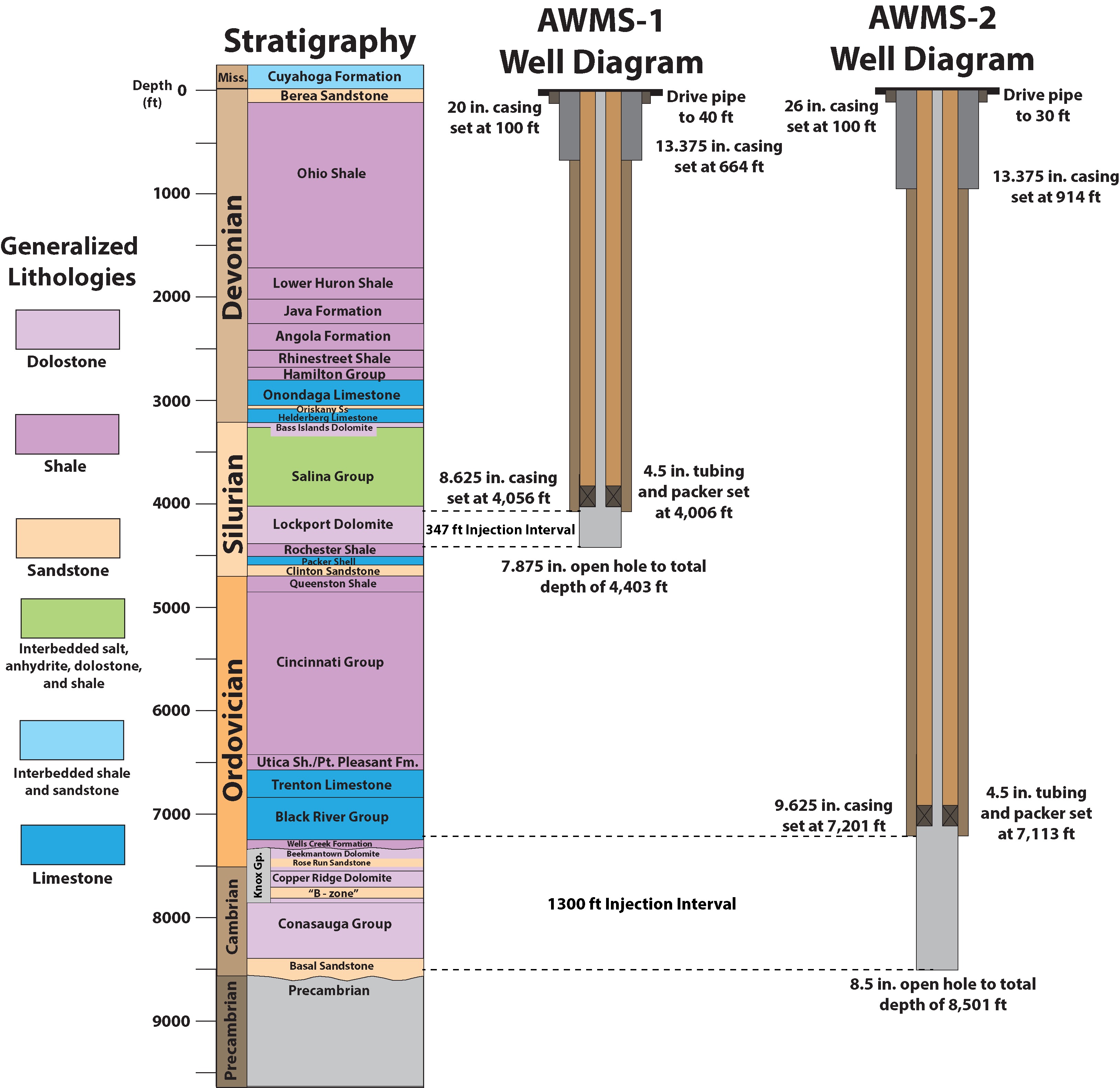
This supplementary material includes a description and figure representing the stratigraphy and well construction of the two wastewater disposal wells (AWMS-1 and AWMS-2) described in the main article.
AWMS-1 and AWMS-2 are located in Weathersfield Township, Trumbull County, Ohio. The wells are located ~34 m (112 ft) apart on a north–south trend at a surface elevation of 277 m (909 ft) above sea level. Based on well-completion records on file with the Ohio Department of Natural Resources (ODNR), drilling of the AWMS-1 well (API 3415524076000) occurred between 13 September and 2 November 2013. The well was drilled as a 44.5-cm-diameter (17.5 in.) hole to a depth of 196 m (644 ft), into which a 34-cm-diameter (13.375 in.) casing was set and cemented into the surface (Figure S1). From 196 m to 1239 m (4061 ft), the well was drilled with a borehole diameter of 31.1 cm (12.25 in). The base of the 22-cm-diameter (8.625 in.) steel production casing was set at 1237 m (4056 ft) and cemented in up-hole to a depth of ~1145 m (~3756 ft). Injection tubing (11.4 cm [4.5 in] diameter) run from the surface was set with a packer at the base of the production casing. AWMS-1 was drilled with a 19.9 cm (7.85 in.) diameter from 1239 m (~4065 ft) to a total depth (TD) of 1342 m (4403 ft).
To facilitate wastewater injection, the lower 106 m (347 ft) of the well was completed “open-hole” between 1237 m (4056 ft) and TD. This interval corresponds to depths of between −959 and −1065 m (−3147 to −3494 ft) below sea level. Drilling and completion records indicate the injection interval is within the Silurian Lockport dolomite (Figure S1). Prior to the initiation of wastewater injection, the open-hole interval was hydraulically fractured with ~55,865 L (14,758 gal) of produced water/friction reduces and treated with ~14385 L (2800 gal) of 28% HCl. Commercial injection was initiated in April, with an allowed maximum surface-injection pressure of ~7.1 MPa (1025 psi). Maximum injection pressures were increased to ~8.3 MPa (1200 psi) following approval on 11 July 2014, based on the actual specific gravity of the injection fluid at 1.05. During AWMS-1 well operations from April to August 2014, >91,600 barrels of wastewater were injected (American Water Management Services [AWMS], personal comm., 2015).
Drilling of the AWMS-2 well (API 3415524075000) occurred between 14 September 2013 and 2 January 2014. The well was drilled as a 44.5-cm-diameter (17.5 in.) hole to a depth of 279 m (914 ft), into which a 34-cm-diameter (13.375 in.) casing was set and cemented into the surface (Figure S1). From 279 m to 2225 m (7297 ft), the well was drilled with a borehole diameter of 31.1 cm (12.25 in.). The base of the 24.5-cm-diameter (9.625 in.) steel production casing was set at 2195 m (7201 ft) and cemented in up-hole to a depth of ~2104 m (~6900 ft). Injection tubing (11.4 cm [4.5 in.] diameter) run from the surface was set with a packer at the base of the production casing. AWMS-2 was drilled with a 21.6 cm diameter (8.5 in.) from 2225 m (7300 ft) to a TD of 2592 m (8501 ft).
The lower ~396 m (1300 ft) of the AWMS-2 well was completed open-hole between 2195 m (~7201 ft) and TD. This interval corresponds to elevations of between −1918 and −2315 m (−6292 to −7592 ft) below sea level. Drilling and completion records indicate the injection interval includes Ordovician Black River group carbonates, Cambrian Knox group dolostones and sandstones, and sandstone and carbonates of the Cambrian Conasauga group (Figure S1). The deepest penetration of the well was into the upper basal sandstones of the Conasauga group (Marysville Formation, commonly referred to as the Mt. Simon sandstone; ODNR, 2012). Using geophysical logs, we correlated lithologic units in the Marysville Formation with similar horizons recorded in the Northstar well ~11.5 km to the southeast in Mahoning County, which was drilled into Precambrian basement. This indicates the bottom of the AWMS-2 well was drilled to ~21 m (~68 ft) above the contact with crystalline rocks of the Precambrian basement, at an elevation of approximately −2330 m (~−7645 ft) below sea level. This projected elevation is supported by regional structure contour maps of the Paleozoic–Precambrian contact constructed by Baranoski (2013).
Prior to the initiation of wastewater injection, hydraulic fracturing of the open-hole interval of the AWMS-2 well was attempted with ~924,600 L (244,258 gal) of produced water/friction reduces and treated with ~14,385 L (2800 gal) of 28% HCl. However, fracture stimulation was unsuccessful due to insufficient downhole pressures (AWMS, personal comm., 2015). Commercial injection was initiated in April 2014 with an allowed maximum surface injection pressure of ~11.6 MPa (1680 psi). Throughout operation of the well through August 2014, >174,000 barrels of wastewater were injected into the Ordovician–Cambrian interval (AWMS, personal comm., 2015).
Table S1. Seismic events detected in this study.
Figure S1. Stratigraphy and well-construction diagram for the Trumbull County, Ohio, American Water Management Services (AWMS) wastewater disposal wells.
Baranoski, M.T. (2013). Structure contour map on the Precambrian unconformity surface in Ohio and related basement features, Geological Survey Map PG-23, Ohio Department of Natural Resources, scale 1:500,000, 17 pp.
Ohio Department of Natural Resources (ODNR) (2012). Preliminary Report on the Northstar 1 Class II Injection Well and the Seismic Events in the Youngstown, Columbus, Ohio, Area, 23 pp., available at http://oilandgas.ohiodnr.gov/portals/oilgas/downloads/northstar/reports/northstar-preliminary_report.pdf (last accessed March 2014).
[ Back ]