This electronic supplement contains a questionnaire for the observation of earthquakes and case histories for the main earthquakes of the Blida region.
This part deals with the type of questionnaires available to us and used in the present research. These questionnaires were set up in 1922 by the Algerian institution in charge of monitoring, the “Institut de Météorologie et Physique du Globe d’Alger,” and were used until 1990.
This part deals with the retrospective construction of the macroseismic fields of the most significant earthquakes that struck the southern border of the Mitidja basin. All studied events are grouped by site, each of which corresponds to a main locality of the region.
According to Ambraseys and Vogt (1988), who are the first authors to report this event, the earthquake occurred on 16 May after midnight and caused heavy damage to the greater part of Blida where many houses collapsed; the inhabitants left the town and camped in the country. The shock was severe at Algiers, and it was followed by many aftershocks. The occurrence date of this event is controversial. According to Sebaï and Bernard (2008), a first consular letter refers to three very strong earthquakes that occurred in the night of 16–17 May at 00:20, with the first one lasting two and one-half minutes (without any mention of damage), whereas a second letter reports a damaging event on 9 June, and this is also attested by another secondary source that we found later on, the periodical Revue Africaine of 1874. This periodical refers to the ephemerides of an official secretary who lived under the Ottoman rule and reported the same information given above, with the only difference being that the occurrence date is cited according to the hegira Muslim calendar, Shawal of the year 1173 Hegira (17 May–15 June 1760), without specifying the date.
Blida is known to have experienced a destructive earthquake on 2 March 1825 in which between 6000 and 7000 people were killed. This event is reported in previous works by all the authors who dealt with the historical seismicity of Algeria (Perrey, 1847; Chesneau, 1892; Galbis, 1932; Sieberg, 1932; Rothé, 1950; Roussel, 1973; Benhallou, 1985; Ambraseys and Vogt, 1988; Ousadou, 2002; El Mrabet, 2005). During the macroseismic survey that we carried out (Harbi et al., 2015), we found 13 primary sources and 29 secondary sources reporting the effects of this event, hence giving us the impression that it was the worst disaster ever to hit the region (see the original information for this earthquake and all the events of the region under study in Data and Resources). The primary sources consist of letters from the Algiers British Consulate reproduced in the British sources and an eyewitness account from an Algerian citizen; all were used by previous seismologists. Generally, the secondary data sources reported the same information but often with exaggeration and brought nothing new, apart from the observation that the city of Koléa also sustained some damage. According to the primary sources, the earthquake, which was extremely violent, totally destroyed the town of Blida, where a mosque, two coffee shops, and five dwellings were the only buildings left standing in that city, and almost half of the population was trapped under the ruins. Two important observations of the seismogeological effects that were also reported consist of the complete drying up of water sources before and during the earthquakes and the occurrence of deep and large ground surface fissures in the immediate neighborhoods of the town. The British consular dispatches provide us with an explanation of this death toll: (1) a vast number of persons were found in the ruins of the mosques, where the people had congregated, the earthquake having occurred at the hour of prayer; (2) the bodies of 280 children were dug out from a Jewish seminary; and (3) the attack on the troops sent by the Government to Blida by the natives, which added to the loss of life. Algeria was under Ottoman rule at that time, and the natives did not want to pass up an opportunity to recapture their city.
A discussion of this event can be found in Ambraseys and Vogt (1988). These authors simply defined a macroseismic epicenter and drew a location map without assigning intensity estimates to the event. It is unlikely that intensity X–XI (Rossi–Forel [RF]) as assessed by Rothé (1970) can be supported. Despite its destructive effects in Blida, there was no damage in Algiers 50 km away. Only a very few secondary sources relate some damage in the old city in the Casbah where the panic caused by the violence of the first shock and the series of aftershocks led the population of Algiers to flee into the country and take refuge in tents.
According to Sieberg (1932; reiterated later by Rothé, 1950), this earthquake was strongly felt in El Affroun and in Blida with intensity VII–VIII Mercalli modified scale (MM). However, the information that we retrieved from local and national newspapers shows that the intensity may not have exceeded VI European Macroseismic Scale (EMS). We are told that the event was strongly felt in Blida where it caused cracks to several houses, but no more information that could justify intensity VIII MM was found. The earthquake was also felt in the El Affroun and Médéa region, causing some fear but without damage and casualties.
Similar to the event cited above, the retrieved information for this event led us to doubt that the VII intensity assigned to Blida by previous authors is accurate. In addition, it is not clear that the macroseismic epicenter is located in Blida where the effects consisted only in the bells tinkling and a strong upset among the population, whereas in Médéa we are told that several persons ran outdoors, and substantial damage was observed in the surrounding area at Ben-Chicao and Berrouaghia. With only this information, it is difficult to reliably characterize the earthquake in terms of intensity and epicenter, which could possibly be between Berrouaghia and Ben-Chicao.
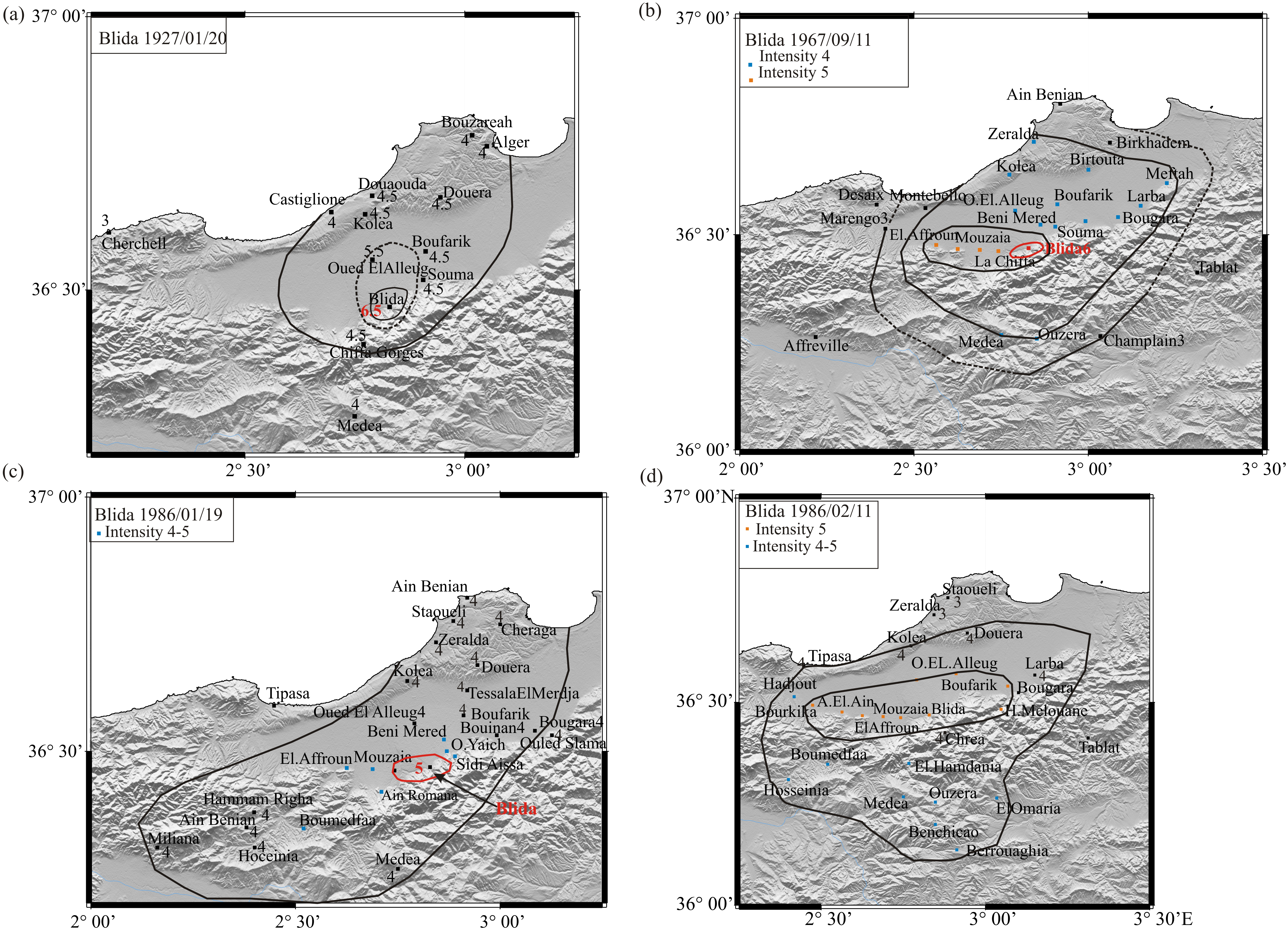
Using press reports, Hée (1927), in Annales de l’Institut du Globe de Strasbourg (AIPGS), described this earthquake as violent, terrifying the population, and causing the fall of chimneys, the collapse of hovels, and cracks to ceilings. On the basis of this information, Hée (1933) attributed an intensity VIII–IX to the gorges of Chiffa and Boufarik; V to Oued El Alleug, Koléa, Douaouda, Castiglione, Médéa, and l’Arba; IV to Algiers; and III to Bouzaréah. According to the press reports that we retrieved, the earthquake was violently felt at Blida, where it lasted 15 s and caused a strong reaction among the population, the shifting of objects, the fall of some chimneys, the breaking of window panes and dishes, and cracks to various ceilings. We are told that the shaking was the strongest to the south of Blida at l'avenue des Moulins, where the damage was more extensive than elsewhere. In the Arab districts of Ouled-Sultan and Bécourt, two old traditional houses collapsed but without casualties. This event was strongly felt at Oued El Alleug, causing upset of its inhabitants who ran outdoors, and at Souma. It was fairly strong at Boufarik, Koléa, Douaouda, Douéra, Médéa, and Bouzaréah, without any material damage, and slight damage at Cherchell. A second shock of less significance was felt in Blida and Souma on 21 January at 11:50. We think that the collapse of the two old houses, probably made of adobe and unreinforced masonry that prevailed at that time, is not a sufficient argument to assign to Blida intensity VIII–IX in terms of the RF scale. From available information, we revised the previous estimates and have drawn an intensity map (Fig. S1a). Our damage scenario corresponds to an epicentral intensity of VI–VII EMS to a maximum.
This is another example on the exaggeration in estimating the intensity of the event. Referring to Institut de Météorologie et de Physique du Globe d’Algérie (IMPGA), Mokrane et al. (1994) allocate intensity VI–VII to Blida with no macroseismic information that could justify this estimate. According to press reports, the shaking was observed at Algiers and more strongly at Blida and Boufarik, where it lasted 5 s and awakened the population with no damage or casualties.
Macroseismic maps of three other strong-to-damaging seismic events, known as Blida earthquakes and drawn from unpublished documentary data, are presented in Figure S1b–d.
This earthquake is not cited in previous catalogs. The information on its occurrence at Rovigo (Bougara now) at midnight and its effects are reported only in the regional newspaper l’Avenir de l’Est. According to this press report, this event frightened the inhabitants, who ran outdoors, and caused cracks to several houses, suggesting an intensity V at minimum. None of the Blida newspapers mention that event, which could be doubtful.
Another event that caused slight damage according to available questionnaires occurred at Bougara on 19 December 1986 (Fig. S2).
The reassessment of the macroseismic data derived from Hée (1931) and Rothé (1950), augmented with the new information that we retrieved from the local and national Algerian press, contributed to our reevaluation of this earthquake, which affected the Blida region. Preceded by a foreshock at 1:40 a.m., the mainshock occurred at Camp des Chênes at about 5:37 a.m. and was accompanied by an underground rumbling that awakened the inhabitants, who then fled their homes. Some damage was observed in the restaurant of this locality, where two chimneys collapsed into their sheath, resulting in a failure of the ceiling; the fall of fairly large pieces of plaster and slight cracks in the wall were also observed. The railway station and the forest house of Camp des Chênes sustained structural damage. In the surroundings, the damage was limited to cracks to some houses of Lodi and to concrete vats at Ameur El Ain. This event was widely observed, and the epicentral region may be defined roughly within an area of about 60 km. The observed effects led us to assign a maximum intensity VI–VII EMS instead of the previous VIII RF estimated in Hée (1931) and to draw the intensity map of Figure S3.
Preceded by three foreshocks, this earthquake caused the breaking of objects and damage to roofs (shifting and breaking of tiles) at Haouch Meurdja, as reported by Grandjean (1954), who assigned an intensity VII RF to this locality on the basis of only this information. We could not find other materials on this event in the archives, and thus we were not able to reconstruct its macroseismic field with more accuracy. However, we think that the maximum intensity does not exceed VI EMS.
Other earthquakes that caused damage at La Chiffa and Hammam Melouane were reassessed on the basis of unpublished documentary data and are represented in the form of macroseismic maps in Figure S4.
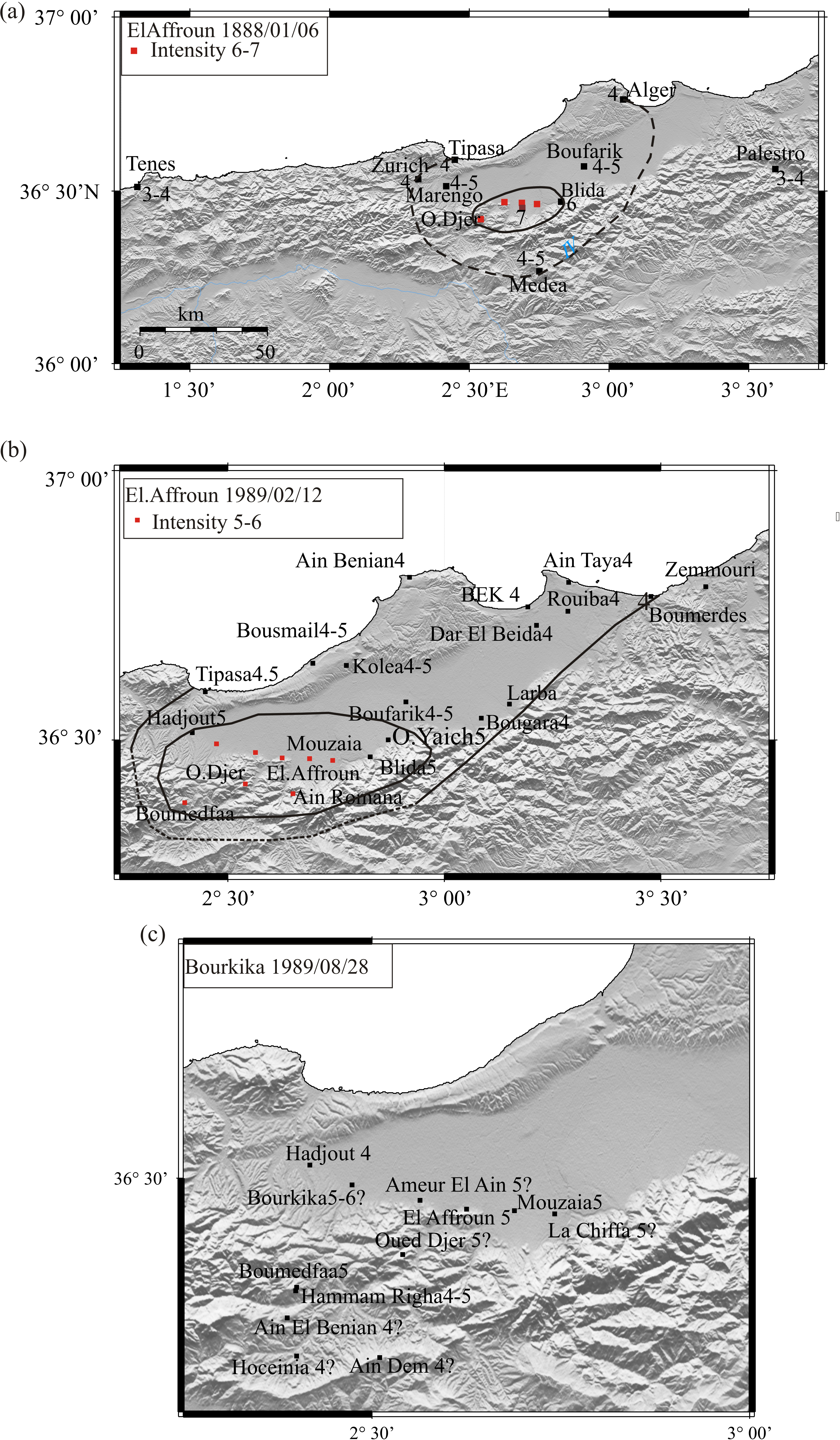
On 2 January 1867 at 07:13:56, a destructive earthquake startled the residents of Mouzaïa and its surroundings. Because of the time of the occurrence and the poor quality of the buildings, the earthquake trapped many people under the ruins of their homes; 48 persons were killed, among whom were a great number of children, and 100 persons were injured. Of the 180 houses that constituted this village of 1600 inhabitants, there remained only the church, which was so strongly cracked that a guard was appointed to ban entry; the clock in the church stopped precisely at 07:15. Bou Roumi, 3 km west of Mouzaïa, was under ruins; four children died; several persons were injured; and many houses were destroyed. The iron bridge of Bou Roumi with its two ashlars abutments sustained heavy damage; the pilasters were detached from the abutments both upstream and downstream; the parapets were disjointed; and the shaking was so violent that some rubble stones came out of their bases. Likewise, Ameur El Aïn, 11 km northwest of Mouzaïa, suffered much damage; three persons were killed and several injured; 25 out of the 98 private buildings collapsed; and the engineer officer in charge of the management of reconstruction work condemned 73 other houses for demolition. On the whole, the loss of life was small compared with the nature and extent of damage. To the west, Bourkika was partially ruined, according to Ambraseys and Vogt (1988), while Marengo, where the earthquake was barely perceived, suffered less, although the telegraph line to Blida was broken at this point. In El Affroun, 5 km west of Mouzaïa, 18 persons lost their lives, and 60 persons were injured; only one house out of more than 100 remained standing; we are told that this one house was preserved thanks to its special type of construction (with no more details). To the southwest of El Affroun in Oued Djer, the people working in the gorges felt earthquakes accompanied with underground rumbling all day long. In La Chiffa, 6 km east of Mouzaïa, several houses were destroyed. Some of the houses were heavily cracked and rendered uninhabitable, but we are told that the village suffered less than Mouzaïa, El Affroun, Bou Roumi, and Ameur El Aïn. In Blida, which was the headquarters of the prefecture at that time, the damage was much less pronounced; only one person was seriously injured by the fall of a chimney following the first shock; most of the inhabitants fled their homes and stayed in the open; the military hospital, the barracks, and the telegraph office had to be evacuated; and all the buildings were badly shaken. A telegram from Blida announced the fall of 40 houses in that town; we are told that only cracks were observed outside the houses, but more serious damage was noticed inside the dwellings, such as the fall of partitions, collapse of ceilings, and wide cracks. The Bab El Rabah Gate of Blida was divided by a large breach and threatened to collapse. However, the Blida theater, built with bricks cemented with lime and sand, resisted the shaking rather well. In Dalmatie, the mainshock lasted 8–10 s and was accompanied by an underground rumbling; some dwellings were seriously damaged. One resident of this village reported that he could not keep his balance during the shaking and that the plaster of the ceilings of his home fell off. Newspapers and periodicals were silent regarding Béni Mered, located at 17 km northeast of Mouzaïa, but Burzet (1869), who visited the epicentral zone in which this village is located, observed that the upper part of the monumental column of Béni Mered was disjointed and moved some centimeters away from its original position. According to the newspaper le Courrier de l’Algérie, Boufarik was slightly affected, whereas Ambraseys and Vogt (1988) told us that it was badly shaken with damage to a number of houses and that chimneys were thrown into public squares, factories, and in the railway station. According to Trumelet (1887), who published a book on Boufarik, this city felt all the shocks that occurred in January 1867, among which the shock on 7 January was so strong in the Duquesne neighborhood that it made the inhabitants flee their homes. Further east in Chebli, the mainshock was strongly felt and lasted 15 s; the clocks stopped; the oscillations of the trees were very pronounced; and slight cracks were observed in almost all the houses. But further south in Bouinan, there is no evidence of serious damage, according to Ambraseys and Vogt (1988). Northeast of Boufarik, in Douéra, we are told that a large number of houses cracked, several walls fell, and some persons were seriously injured, whereas to the northwest in Koléa, all the dwellings suffered except those built of bricks which sustained slight damage. South of Mouzaïa, the town of Médéa has also suffered much; two houses collapsed and a large number cracked; and one pavilion of the military hospital that heavily cracked had to be evacuated. In the vicinity of Médéa, the village of Lodi was strongly damaged, whereas Damiette suffered less. Algiers, the capital located 50 km from the center of the shaking, was not spared either. The mainshock, which lasted 8 s, was strong enough that the entire population chose to flee from their homes into the streets and open spaces or outside the city into the fields; most of the clocks stopped; walls, furniture, windows, and doors were badly shaken; and many objects on the chimneys and shelves fell and broke. A wall of the Mosque in the Place of Government collapsed, and the clock tower of the Hotel du Tresor was damaged. No casualties among the population were reported in Algiers. However, all the buildings of Algiers, Mustapha Supérieur, Agha, and El Biar were more or less affected; some of them collapsed; deep cracks were observed on the façade of the tobacco factory in Hussein Dey; some ceilings collapsed in the upper part of the town in Kouba and El Biar, where stones were detached from cracked vaults or arches in the Moorish houses. A citizen living in downtown Algiers near the Government Palace reported that in his flat, two arches of a vault and all the periphery of his terrace were cracked; his chimney was cut in two. The telegraph connecting Algiers to Blida was broken, but the Algiers–Blida railway line suffered no damage. West of Algiers in Cherchell, the earthquake caused cracks in 28 buildings (barracks, stores, customs house, school, police station, rampart, and fodder park); chimneys were partly ruined. In Miliana, the shaking was so violent that many people ran outdoors; in the hospital the patients were thrown to the ground. All the Miliana buildings were cracked; all the ceilings of the third floor of the new hospital fell. The mainshock caused a little damage to Duperré without casualties. Further west, in Orléansville several persons who were on the ground floor felt absolutely nothing, whereas those living on the first or second floor were moderately shaken. It is reported that when a sergeant living on the second floor of the Orléansville hospital was suddenly awakened by the shocks, he ran to the windows and observed the swinging of the trees, although no breeze existed. His dog was scared and barked several times; the patients in the first and second floor of the hospital felt horizontal vibration. North of Orléansville, in Ténès, which seems to be the northwestern limit of this earthquake, no damage nor casualty was reported, as well as at the southern limit, which is Theniet El Had. Further southeast, the mainshock was felt at Boghar and Aumale with no concern. In Kabylie northeast of Mouzaïa, no damage was reported at Dra-El-Mizan, Fort National, Tizi-Ouzou, and Dellys. At Djidjelli, two or three persons living by the sea said that they felt a barely perceptible shaking. The Mouzaïa–El Affroun (MEA) earthquake was not felt at Oran, Laghouat (about 300 km west and south of Mouzaïa, respectively), and Constantine (about 350 km east of Mouzaïa). The Bulletin de la Société de Médecine d’Alger published in its report of 1868 that the MEA earthquake was felt at Djelfa (200 km distant), where some effects were observed; this periodical is the only source which reported that observation. Actually, this is a confusion with the 4 February 1867 Boussaada earthquake, which affected the Djelfa region (Harbi and Maouche, 2009).
The MEA earthquake induced effects on the natural surroundings. It triggered rockfalls that cut the Blida–Médéa road. We are told that in the Chiffa gorges, stones and rocks were detached in a terrific crash and broke the dumptrucks of the engineers. In Oued Djer, employees in charge of the construction of the railway observed a large crack in one of the trenches; fissures on the river bed were also reported. Ambraseys and Vogt (1988) gave more details on these fissures; a long ground fracture was produced near Bouroumi that extended for some distance to the west; another crack, 200-m-long and 30 cm wide, was reported from Oued Djer; and a third was reported from between El Affroun and Ameur El Aïn, running to the southwest, along the foothills of Djabal Nador. Large landslides and rockfalls were reported from the Djabal Beni Sala, where it is said that the ground opened up extensively. The origin and exact location of these features are not known. After visiting the epicentral area, Aucapitaine reported to Perrey (1870) that the fissure observed beyond Bou Roumi, according to the first press reports, is simply a land subsidence. In his report to the journal The Times, an English witness who visited the epicentral area at the foothills of the Atlas confirmed the existence of these crevasses but thought that their widths were exaggerated by the first observers and would not exceed 8.5 inches (see Data and Resources). There were no fissures in the soil of Mouzaïa, however near Ameur El Aïn, ground movements were so severe that old olive trees were uprooted, and level ground slumped (Ambraseys and Vogt, 1988). In Oued Djer at the slopes of the Nador Mountain, the springs dried up, leaving the inhabitants and their cattle without water.
Finally, a last phenomenon that occurred at the time of the first shock seems strange for a seismic source located inland at least 15 km away from the coast. We are told that, as a result of the earthquake, the sea rose by one meter in Algiers harbor, and the water was suddenly at the wharf.
This earthquake is reported in Rothé (1950) who referred to Hée (1950) and attributed an intensity of VII on the RF scale to the event, based on the cracks reported in the dwellings of El Affroun. However, the information that we collected led us to revise downward the intensity estimate (Table 3 in the main article) because the cracks were not as serious as claimed by Hée (1950), according to a witness account published in the local journal (see the related information in Data and Resources).
Twenty-one years after the destructive earthquake of the 1867 Mouzaïa–El Affroun earthquake, an earthquake struck the same region with noticeable effects. It caused considerable damage in El Affroun, Mouzaïa, and at the Smith farm, located between El Affroun and la Chiffa at the foot of the Blida Mountain, where partitions and chimneys toppled and walls of several buildings seriously cracked; in Oued Djer one house partially collapsed. In Blida, china and glasses clattered together, a few mirrors were broken, and cracks to some ceilings were observed; the inhabitants camped outside despite the cold and the rain. Everywhere in the southern Mitidja region, the shock caused a great panic among the inhabitants who could not stay indoors, but fortunately there were no casualties. The earthquake awakened the people of Marengo and was strong to fairly strong at Médéa, Boufarik, and Algiers; it was also felt at Ténès, El Harrach, Tipasa Zurich, and Palestro and was followed by two aftershocks on 15 and 16 January that were felt in the whole epicentral area. A reassessment of the macroseismic data augmented with the new information that we retrieved from the local and national Algerian press led us to tentatively revise the macroseismic epicenter and intensities previously estimated by Rothé (1950) and to draw for the first time an intensity map for this event (Fig. S5a).
On 31 October 1988, a damaging earthquake occurred in the Mouzaïa–El Affroun region and was followed on 12 February 1989 by another seismic event that occurred at El Affroun, causing some damage to the city and its surroundings, according to the questionnaires available to us. The same region was again struck on 28 August 1989 by an earthquake that was unfortunately not recorded by the seismic networks; it caused fissures to 50 dwellings at Bourkika and some buildings of the city of Boumedfaa, where fissures on the ground were also observed. The lack of detailed information does not allow us to accurately reconstruct the macroseismic field of either event, both of which seem to belong to the seismic sequence that followed the 31 October 1988 earthquake (Fig. S5b,c).
Figure S1. Intensity maps of the most significant earthquakes that occurred in the vicinity of Blida.
Figure S2. Intensity map of the 19 December 1986 Bougara earthquake.
Figure S3. Intensity map of the 4 March 1931 Camp des Chênes earthquake.
Figure S4. Intensity maps of the most significant earthquakes that occurred in La Chiffa and Hammam Melouane.
Figure S5. Intensity maps of the most significant earthquakes that occurred in the El Affroun region.
The information for the 2 March 1825 earthquake and all the events of the region under study and all the information related to the 1867 Mouzaïa–El Affroun (MEA) earthquake is available at http://naget.ictp.it/PUBLICATIONS/resources/AMD.pdf (last accessed April 2017).
Ambraseys, N. N, and J. Vogt (1988). Material for the investigation of the seismicity of the region of Algiers, Eur. Earthq. Eng. 3, 16–29.
Benhallou, H. (1985). Les Catastrophes Séismiques de la Région d’Echéliff dans le contexte de la Séismicité Historique de l’Algérie, Thèse de Doctorat es-Sciences, IST-USTHB, Algiers, Algeria, 294 pp. (in French).
Burzet (l’abbé) (1869). Histoire des désastres de l’Algérie, 1866–1867–1868, Imprimerie Centrale Algérienne, Algiers, Algeria (in French).
Chesneau, M. (1892). Note sur les tremblements de terre en Algérie, Mém. Ann. Mine. 9, 5–46 (in French).
El Mrabet, T. (2005). The Great Earthquakes in the Maghreb Region and Their Consequences on Man and Environment, CNRST-LAG, Rabat, Morocco, 424 pp.
Galbis, R. J. (1932). Catalogo sismico de la zone comprendida entre los meridianos 5°E. y 20°W. de Greenwich y los paralelos 45° y 25°N, Imprenta de Ramona Velasco, Madrid, Spain (in Spanish).
Grandjean, A. (1954). Séismes d’Algérie de 1940 à 1950 inclus, Annales de l’Institut de Physique du Globe de Strasbourg VII, 83 (in French).
Harbi, A., A. Sebaï, M. Benmedjber, F. Ousadou, Y. Rouchiche, A. Grigahcene, D. Aïni, S. Bourouis, S. Maouche, and A. Ayadi (2015). The Algerian homogenized macroseismic database (267–1989): A deeper insight into the Algerian historical seismicity, Seismol. Res. Lett. 86, no. 6, 1705–1716.
Harbi, A., and S. Maouche (2009). Les principaux séismes du Nord-Est de l'Algérie, Mémoires du Service Géologique National, no. 16, 81 pp. (in French).
Hée, A. (AIPGS by) (1919–1939). Les séismes de l'Algérie, Annales de l'Institut de Physique du Globe de Strasbourg, 2e partie, Séismologie, t, I–IV (in French).
Hée, A. (1950). Catalogue des séismes algériens de 1850 à 1911, Annales de l’Institut de Physique du Globe de Strasbourg, 41–49 (in French).
Mokrane, A., A. Ait Messaoud, A. Sebai, N. Menia, and A. Ayadi (1994). Les séismes en Algérie de 1365 à 1992, Publication du Centre de Recherche en Astronomie, Astrophysique et Géophysique, Etudes et Surveillance Sismique, ESS, CRAAG, Alger-Bouzaréah, 277 pp. (in French).
Ousadou, F. (2002). Contribution à la sismotectonique de l’Algérie occidentale par la sismicité, les mécanismes au foyer, les mesures de défromation et la tectonique générale, Magister Thesis de, FSTGAT-USTHB, Algiers, Algeria, 133 pp. (in French).
Perrey, A. (1847). Note sur les tremblements de terre en Algérie et dans l'Afrique septentrionale, Mémoires de l'Académie des Sciences, Arts et Belles Lettres de Dijon, années 1845–1846, 299–323 (in French).
Perrey, A. (1870). Note sur les tremblements de terre en 1866 et 1867, avec suppléments pour les années antérieures, de 1843 à 1865, Mémoires couronnés et autres mémoires de l'Académie Royale des Sciences, des Lettres et des Beaux Arts de Belgique, 1–223 (in French).
Rothé, J. P. (1950). Les séismes de Kherrata et la séismicité de l’Algérie, Bulletin du Service de la Carte Géologique de l’Algérie, 4 ème série, Géophysique, Vol. 3, 1–40 (in French).
Rothé, J. P. (1970). Mission d'information séismologique, novembre–décembre 1869, Moyen-Orient et Afrique du Nord, UNESCO Report No. 1759/BMS.RD/SCE, Paris, France (in French).
Roussel, J. (1973). Les zones actives et la fréquence des séismes en Algérie 1716–1970, Bulletin de la Société d’Histoire Naturelle d’Afrique du Nord 64, no. 3, 11–227 (in French).
Sebaï, A., and P. Bernard (2008). Contribution à la connaissance de la sismicité d’Alger et de ses alentours au XVIIIe siècle, extraite des archives françaises, Compt. Rendus Geosci. 340, 495–512 (in French).
Sieberg, A. (1932). Erdbeben geographie, in Handbuch der Geophysik, Vol. 4, Berlin, Germany, 687–1005 (in German).
Trumelet, C. (1887). Blida, Récits selon la légende, la tradition et l’histoire, A. Jourdan (Editor), Algiers, Algeria (in French).
[ Back ]