Electronic Supplement to
Developing Seismogenic Source Models Based on Geologic Fault Data
by Kathleen M. Haller and Roberto Basili
Appendix A
Only parameters we derive directly from geological observations are documented here. All other parameters that might be required for probabilistic seismic-hazards assessment can be calculated separately. Field names are exactly as reported in the original databases. Format and name of variables here are reported in a simpler form than that used in the original databases (Table A1). Format and name of variables in the database table definitions (Appendices B and C) are reported as they are in the original data models; therefore they define the real content more accurately but their names vary depending on the database language used.
Definitions of variable names used in the text.
| Variable name | Definition | Precision |
|---|---|---|
| String | Text composed of a variable number of characters | N/A |
| Integer | Integer number | equals to one unit |
| Real | Real number with decimals | varies with number of decimals |
List of fundamental seismogenic source properties
Coding and Naming
To uniquely identify each database record USGS uses a
positive ordinal whereas INGV uses a seven-character code with the format CCTT###, where
CCis a two-character code indicating the name of an officially recognized country as documented at:
http://www.iso.org/iso/country_codes/iso_3166_code_lists.htm.TTis a two-character code that identifies the type of data. In the case illustrated here this code is always “CS” for Composite Source.###is an unique ordinal between 1 and 999 (including leading zeroes).
To convert from one to the other requires a simple text string manipulation. Care should be taken when going from INGV to USGS because when the first four characters are stripped from the INGV identification code, the remaining ordinal may not be unique. In addition the character limit for the ordinal in the INGV table is smaller than that of USGS, therefore when converting from USGS to INGV some unique identifiers could be truncated. An efficient way to overcome these problems is simply to reassign unique ordinals and store this information in a relational table.
| Database | INGV | USGS |
|---|---|---|
| Field name | DSource | CFAULT_OR |
| Variable | String | String |
| Unit | N/A | N/A |
Both databases also provide a human-friendly name to identify records. For USGS this is the name assigned in the literature to the tectonic structure that forms the record. For INGV this is an assigned local geographic name. The character limit in the INGV table is smaller than that of USGS, therefore when converting from USGS to INGV some of the names could be truncated. The resulting loss of information should not be critical because this field need not be unique for manipulating or using the database in calculations.
| Database | INGV | USGS |
|---|---|---|
| Field name | SourceName | NAME |
| Variable | String | String |
| Unit | N/A | N/A |
Seismogenic Source Definition
Geographic location: Reference datum is WGS84 in both. Conversion from the original datum and projection system into others can also be done using standard tools available in any GIS. Usage of conformal projections as opposed to equal-area or other equivalent projections is recommended.
Depth: Depth defines the location of seismogenic sources in the third dimension within the crust. Both INGV and USGS databases provide the depth of the upper and lower edges of seismogenic sources, in kilometers. The USGS reference is local topography whereas the INGV reference is sea level. For exact conversion between the two databases a Digital Elevation Model (DEM) is needed to calculate average terrain elevation to add to INGV or subtract from USGS seismogenic source depth values. Worldwide, freely available DEMs, such as ETOPO2 or GTOPO30, are accurate enough to provide this information for the purpose of seismogenic source modeling. Special care should be taken with depth of sources when compared with hypocenters of seismic events that are usually provided as depth below sea level.
| Database | INGV | USGS |
|---|---|---|
| Field name 1 | MinDepth | PREF_UPPER_DEPTH |
| Field name 2 | MaxDepth | PREF_LOWER_DEPTH |
| Variable | Real | Real |
| Unit | kilometer | kilometer |
Strike: Although both databases use the same concept for strike, USGS does not include strike values as an attribute. Strike can be calculated from the map object, an operation that is easy to perform within any GIS. In our experience, short localized changes in strike that represents less than 20 percent of the entire length could be ignored or weighted such that they do not contribute to the derived strike value. Conversion between the two datasets does not require any manipulation and the user can rely on the internal consistency of map features and strike intervals.
| Database | INGV | USGS |
|---|---|---|
| Field name 1 | StrikeMin | N/A |
| Field name 2 | StrikeMax | N/A |
| Variable | Integer | N/A |
| Unit | degree | N/A |
Dip: As in other cases, USGS retains a single preferred dip value or three alternative values whereas INGV retains a range of variability of dip values. To convert values in the INGV dataset to the USGS preferred value, one can assign the median between the interval extremes as a single preferred value or assign three alternative solutions for each record as minimum, median, and maximum. Conversion from the USGS to INGV format can be done by adding and subtracting ε (with ε ≥ 0 deg) to single preferred values and by taking the extreme values when the three alternatives are found.
| Database | INGV | USGS |
|---|---|---|
| Field name 1 | DipMin | PREF_DIP |
| Field name 2 | DipMax | N/A |
| Variable | Integer | Integer |
| Unit | degree | degree |
Length and width: Although both databases use the same geometric idealization, INGV does not include length and width values as attributes of the database records. Therefore, they need to be calculated in the INGV to USGS conversion. Length is defined as along trace length in kilometers in the USGS database. Length can be calculated from the map objects, an operation that is easy to perform within any GIS. Length values obtained in such way can vary depending on mapping accuracy, GIS functions and planar/spherical earth assumptions; however, differences should be smaller than the accuracy requirements in seismic hazard calculations.
| Database | INGV | USGS |
|---|---|---|
| Field name 1 | N/A | CALC_LENGTH |
| Variable | N/A | Real |
| Unit | N/A | kilometer |
For INGV sources, width (in kilometers) can be calculated from depth interval and dip angles as the average source width by using the following formula:
2
where W is width, D is depth, and δ is dip angle.
| Database | INGV | USGS |
|---|---|---|
| Field name 1 | N/A | CALC_WIDTH |
| Variable | N/A | Real |
| Unit | N/A | kilometer |
The USGS to INGV conversion does not require any manipulation, and the user can rely on the internal consistency of map features and length/width values.
Seismogenic Source Behavior
Rake: As in other cases, USGS retains a single preferred rake value whereas INGV retains a range of variability of rake values. To convert values in the INGV dataset to the USGS preferred value, one can assign the median between the interval extremes as a single preferred value. One can convert the USGS data to INGV format by adding and subtracting ε (with ε ≥ 0 deg) to single preferred values. Care should be taken in the conversion because, although both INGV and USGS measures rake as the angle formed between the direction of slip and the horizontal, positive counterclockwise, INGV adopts the interval 0/2π whereas USGS adopts the interval –π/π (Figure A1).
| Database | INGV | USGS |
|---|---|---|
| Field name 1 | RakeMin | PREF_RAKE |
| Field name 2 | RakeMax | N/A |
| Variable | Integer | Integer |
| Unit | degree | degree |
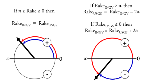
▲Figure A1. Rake represents the direction of slip parallel to the seismogenic source surface. Both INGV and USGS measure rake as the angle formed between the direction of slip and the horizontal, positive counterclockwise. INGV (red) in the interval 0/2π; USGS (blue) in the interval –π/π.
Slip rate: As in other cases, USGS retains a single preferred slip rate value whereas INGV retains a range of variability of slip rate values. To convert values in the INGV dataset to the USGS preferred value, one can assign the average between the interval extremes as a single preferred value. One can convert the USGS data to INGV format by adding and subtracting ε (with ε ≥ 0 deg) to single preferred values.
| Database | INGV | USGS |
|---|---|---|
| Field name 1 | SlipRateMin | CALC_FAULT_PAR_SR FAULT_PAR_SR (CA only) |
| Field name 2 | SlipRateMax | N/A |
| Variable | Real | Real |
| Unit | mm/year | mm/year |
Magnitude: Since USGS and INGV use the same magnitude scale, the conversion is straight forward. The USGS uses alternative magnitude relations for sources in California shown in brackets.
| Database | INGV | USGS |
|---|---|---|
| Field name 1 | MaxMag | CALC_WC_MAG_L [CALC_HB_MAG; CALC_ELLS_MAG] |
| Variable | Real | Real |
| Unit | scalar | scalar |
References
Ellsworth, W., 2003, "Appendix D—Magnitude and area data for strike slip earthquakes", in Working Group on California Earthquake Probabilities, Earthquake Probabilities in the San Francisco Bay Region—2002–2031. U.S. Geological Survey Open-File Report 03–214, 6 pps.
Hanks, T. C., and W. H. Bakun (2002). A bilinear source-scaling model for M–log A observations of continental earthquakes. Bulletin of the Seismological Society of America 92, 1841–1846.
[ Back ]