This electronic supplement presents annotated surface rupture maps for 40 earthquakes. Of these, 39 are new syntheses, and one, the 1887 Sonora, Mexico event, revises an earlier version in Wesnousky (2008). Summary maps extend the compilation of Wesnousky (2008) and use the same format. A surface rupture map is provided for each earthquake, redrawn and distilled from field mapping by one or sometimes multiple original sources. Each map is annotated as appropriate with measurements of steps inside or at the ends of the rupture. The narrative describes the literature consulted, the parametric measurements we infer, and relevant associated seismic, geologic, or geophysical measurements. Figures S25 and S36 each summarize two earthquakes.
Figure S1. Surface rupture for the 1887 Sonora, Mexico, earthquake, updating the map of Wesnousky (2008).
Figure S2. Surface rupture for the 1892 Laguna Salada, Mexico, earthquake.
Figure S3. Surface rupture for the 1905 Bulnay, Mongolia, earthquake.
Figure S4. Surface rupture for the 1911 Chon-Kemin, Kyrgyzstan, earthquake.
Figure S5. Surface rupture for the 1915 Avezzano, Italy, earthquake.
Figure S6. Surface rupture for the 1920 Haiyuan, China, earthquake.
Figure S7. Surface rupture for the 1927 Kita-Tango, Japan, earthquake.
Figure S8. Surface rupture for the 1928 Subikia–Laikipia, Kenya, earthquake.
Figure S9. Surface rupture for the 1931 Fuyun, China, earthquake.
Figure S10. Surface rupture for the 1932 Changma, China, earthquake.
Figure S11. Surface rupture for the 1953 Yenice–Gonen, Turkey, earthquake.
Figure S12. Surface rupture for the 1956 San Miguel, Baja California, Mexico, earthquake.
Figure S13. Surface rupture for the 1957 Gobi-Altai, Mongolia, earthquake.
Figure S14. Surface rupture for the 1962 Buyin Zara, Iran, earthquake.
Figure S15. Surface rupture for the 1967 Mogod, Mongolia, earthquake.
Figure S16. Surface rupture for the 1968 Dasht-e-Bayaz, Iran, earthquake.
Figure S17. Surface rupture for the 1970 Gediz, Turkey, earthquake.
Figure S18. Surface rupture for the 1977 Bob-Tangol (Gisk-Kirman), Iran, earthquake.
Figure S19. Surface rupture for the 1978 Tabas, Iran, earthquake.
Figure S20. Surface rupture for the 1979 Khuli-Buniabad, Iran, earthquake.
Figure S21. Surface rupture for the 1980 Irpinia, Italy, earthquake.
Figure S22. Surface rupture for the February 1981 Corinth, Greece, earthquakes.
Figure S23. Surface rupture for the March 1981 east Gulf of Corinth, Greece earthquake.
Figure S24. Surface rupture for the 1986 Kalamata, Greece, earthquake.
Figure S25. Surface rupture for the 1988 Lancang and Gengma, China, earthquakes.
Figure S26. Surface rupture for the 1988 Spitak, Armenia, earthquake.
Figure S27. Surface rupture for the 1990 Rudbar, Iran, earthquake.
Figure S28. Surface rupture for the 1995 Sakhalin Island, Russia, earthquake.
Figure S29. Surface rupture for the 1997 Zirkuh, Iran, earthquake.
Figure S30. Surface rupture for the 2005 Kashmir, Pakistan, earthquake.
Figure S31. Surface rupture for the 2005 Dahuiyeh (Zarand), Iran, earthquake.
Figure S32. Surface rupture for the 2008 Wenchuan, China, earthquake.
Figure S33. Surface rupture for the 2009 Karonga, Malawi, Africa, earthquake.
Figure S34. Surface rupture for the 2010 Darfield (Christchurch), New Zealand, earthquake.
Figure S35. Surface rupture for the 2010 El Mayor–Cucapah, Mexico, earthquake.
Figure S36. Surface rupture for the 2010 Yushu, China, earthquakes.
Figure S37. Surface rupture for the 2011 Iwaki (Fukushima–Hamadori), Japan, earthquake.
Figure S38. Surface rupture for the 2014 Napa, California, earthquake.
Figure S1. Surface rupture for the 1887 Sonora, Mexico, earthquake, updating the map of Wesnousky (2008).
Sonoran, Mexico
3 May 1887
Normal Mechanism
This map updates Wesnousky (2008) using later sources. The earthquake produced surface ruptures along an array of three northerly striking fault planes (the Pitaycayachi, Teras, and Otates fault segments) along the western margin of the Sierra Madre Occidental Plateau of northern Mexico (Bull and Pearthree, 1988; Suter, 2006, 2008a,b). Suter (2008a) estimates a geologic moment magnitude (Mw) of 7.5 ± 0.3 based on the end-to-end length of 102 km. Normal, down-to-the-west displacements and scarp heights reach to a meter or greater along all three segments. The Pitaycayachi and Teras faults are separated by a right step of about 2 km. The Teras and Otates rupture segments are separated by an ~8 km left step, across which the measured distance of trace endpoints is ~12 km along strike. If measured perpendicular from the unruptured extension of the Otates fault, the step from the Teras segment measures ~5 km. The maps exhibit numerous gaps along the trace, but they could be due to lack of preservation and/or the difficulty of mapping in the very rough terrain. For our analysis, the rupture trace is broken by a 2 km right step between the Pitaycayachi and Teras segments and 5 km left step between the Teras and Otates segments. Fault maps do not continue beyond rupture ends.
Figure S2. Surface rupture for the 1892 Laguna Salada, Mexico, earthquake.
Laguna Salada, Mexico
23 February 1892
Strike-Slip (Oblique-Normal) Mechanism
Mueller and Rockwell (1995) mapped the rupture ~100 years after the event and reported surface rupture of at least 22 km along the margin of Laguna Salada basin, with an average of 4 m dextral and 3.5 m normal slip on a fault-dipping 55°–70° southwest. Hough and Elliot (2004) estimate an Mw 7.2 for the event based on analysis of seismic intensity data. Light Detection and Ranging (LiDAR) was flown for the 2010 Sierra–El Mayor earthquake, which reactivated portions of the 1892 rupture trace (Fletcher et al., 2014). Utilizing the LiDAR, Mueller et al. (2010) reexamined the 1892 rupture trace and found that the 1892 rupture extended further northward for a rupture length of ~42 km. We combined the two mapping studies for the map presented here. Gaps are not counted due to the potential for lack of preservation of original scarps. Mapping suffices to conclude that there were no steps ≥1 km in the fault trace. Rupture ends to the south at a near-90° bend in the rupture trace. Available maps do not provide information on the geometry of active faults past the rupture endpoints.
Figure S3. Surface rupture for the 1905 Bulnay, Mongolia, earthquake.
Bulnay, Mongolia
23 July 1905
Strike-Slip, Left-Lateral Mechanism
The Bulnay, Mongolia, rupture of 23 July 1905 had a magnitude greater than M 8 based on surface-wave methods (e.g., Kanamori, 1977; Khil’ko et al., 1985). Schlupp and Cisternas (2007) use body waves measured within the passband of the seismic sensors and estimate the magnitude between 8.3 and 8.5 (M0 3.97 × 10²¹ to 7.27 × 10²¹ N·m). Surface rupture was initially mapped and partially photographed in 1905 (Voznesenskii, 1962). Resurveys of the fault zone were undertaken by Khil’ko et al. (1985) and Baljinnyam et al. (1993). Schwartz et al. (2009) measured coseismic displacement at several points on the main trace of the rupture. Rizza et al. (2015) report on a detailed study ~80 km of the rupture. Major secondary ruptures on the Teregtiyn and Dungen faults totaled about 100 km in length. The Teregtiyn rupture is 80 km long: 20 km with 3.2 ± 1 reverse faulting on a 50°–70° northeast-dipping plane and 60 km of en-echelon faults with 3.0 ± 1 m strike slip. The association of the Teregtiyn rupture with the main Bulnay rupture is strongly suggested from modeling of horizontal seismograms by Schlupp and Cisternas (2007). The Dungen rupture is conjugate to the main rupture, 20–22 km in length, and estimated to have 1.5 ± 0.5 m slip on a vertical plane. Many other shorter scarps were recognized in the field but not included in the summary mapping.
We summarize the map of Baljinnyam et al. (1993) and detailed mapping from Rizza et al. (2015). The rupture length was ~375 km, with an average surface displacement of 8.9 m in the 80 km section mapped by Rizza et al. (2015) and 6.5 m overall. No steps of >1 km were noted along strike of the rupture, although Rizza et al. (2015) do describe smaller steps. Steps or gaps are not considered for the secondary ruptures. At both ends of the rupture, the fault on which the event occurred appears to continue without discontinuities. Because of the age of the rupture and state of mapping, we did not attempt to estimate gaps in the main trace.
We did not include the Tsetserlag Mw 8.0 earthquake that occurred two weeks prior to the Bulnay earthquake (Schlupp and Cisternas, 2007) because of the inconsistencies between available geologic and seismic data.
Figure S4. Surface rupture for the 1911 Chon-Kemin, Kyrgyzstan, earthquake.
Chon-Kemin, Kyrgyzstan
3 January 1911
Reverse Mechanism
The Mw 7.7 Chon-Kemin (Kebin) earthquake of 3 January 1911 was the third large reverse event affecting the Tien Shen region of Kyrgyzstan (Molnar and Ghose, 2000; Delvaux et al., 2001). Ground rupture was characterized by major reverse faulting on multiple subparallel strands. The surface rupture was studied shortly after the event by Bogdanovich et al. (1914) and more recently by Delvaux et al. (2001). Maps by Arrowsmith et al. (2005) and C. Crosby (written comm., 2013) were used in constructing our map. Arrowsmith et al. (2005) estimate a rupture length of 177 km and an average displacement of 3.6 m. Average dip is ~60°, as reported by C. Crosby (written comm., 2013). Kulikova and Krüger (2015) reanalyzed seismic records from 23 worldwide stations. They estimate an Mw 8.02 and propose (from regression relations) a rupture length of 260–300 km. Their magnitude estimate is thus somewhat larger than the geologic moment of Arrowsmith et al. (2005): M0 3.86 × 10²⁰ and Mw 7.72.
For this study, we counted only the one large step between western and eastern primary traces of the rupture. Gaps were not estimated because of uncertainties in preservation and the difficulty of fieldwork in much of the rupture area. Faults are likely to continue both to the west and east, but available mapping is not considered adequate to include the rupture ends in the data table.
Figure S5. Surface rupture for the 1915 Avezzano, Italy, earthquake.
13 January 1915
Avezzano, Italy
Normal Mechanism
The M 6.9 Avezzano earthquake produced scarps on both sides of the Fucino Plain in the central Apennine Mountains east of Rome, Italy. The Fucino Plain is one of a number of valleys bounded by a discontinuous system of northwest-trending normal faults. Geologically, these faults accommodate current extensional tectonics, but they sometimes reoccupy and interact with previously developed reverse faults. Surface ruptures occurred on four physically separated faults. Primary faults dip southwest and include the San Benedetto de Marsi-Gioia de Marsi (SGBF) and Marsicana Highway (MHF) faults. Secondary faults on the southwest side of the basin also ruptured; the southwest-dipping Trasacco fault (TF) and northeast-dipping Luco de Marsi fault (LMF). Our rupture map is adapted from Galadini and Galli (1999), who combined historical data with paleoseismic investigations at 12 locations. Geodetic models put rupture on a plane striking 135° and plunging 63° to the southwest (Ward and Valensise, 1989; Amoruso et al., 1998).
We identify two internal steps, a northeast step of 4 km and a west step of 7 km, both from the SGBF. At the southeast end of rupture on the SGBF, there is a step of 3 km to the next active fault. To the north, rupture ends essentially with the mapped trace of the MHF, separated with a gap on the end of 3 km and a <1 km step to the Monti della Duchessa fault. It is not clear from available mapping how the TF continues to the southeast. There appears to have been a gap of 4 km in the MHF rupture trace; however, because mapping uncertainties, we do not include the Avezzano earthquake in accounting of gaps.
Figure S6. Surface rupture for the 1920 Haiyuan, China, earthquake.
Haiyuan, China
16 December 1920
Strike-Slip Mechanism
The earthquake produced left-lateral surface rupture along an ~237-km-long section of the Haiyuan fault in central Asia (Liu-Zeng et al., 2007). Chen and Molnar (1977) report a seismic moment estimate of 3 × 10²¹ N·m, equivalent to Mw 8.3. The characteristics of surface rupture are discussed in Qidong et al. (1986) and Zhang et al. (1987). Qidong et al. (1986) worked within an 170–180-km-long section of the fault and provided a detailed strip map of an 140 km portion of it. We rely primarily on their map. Horizontal displacements of 2–10 m were measured along the trace. Within the mapped section, four releasing steps and one restraining step are observed. With respect to this report, two of the releasing steps are ~1 km in width, one is ~2 km, and the remaining one is 4 km. The restraining step is 5 km. The smaller-scale mapping of Liu-Zeng et al. (2007) suggests that active fault trace continues without geometric interruption past each end of the rupture trace, but the scale of mapping is insufficient to make the interpretation with confidence.
Figure S7. Surface rupture for the 1927 Kita–Tango, Japan, earthquake.
Kita–Tango, Japan
27 July 1927
Strike-Slip Mechanism
The Mw 7.0 (Kanamori, 1973) Kita–Tango earthquake occurred on 7 March 1927 on the Tango Peninsula in the Kyoto Prefecture, Japan. Faults in this region accommodate contraction of the overriding plate associated with convergence along the Japan trench (Wesnousky et al., 1982). The main earthquake fault (Tango fault) slipped left laterally with a component of reverse slip (generally west-side up) (Yamasaki and Tada, 1927). The Tango fault rupture is exposed onshore for a distance of 14.5 km (Yamasaki and Tada, 1927) to 17 km (Kaneda, 2003) along the Gomura fault. The extension of the rupture trace offshore into the Japan Sea is suggested by geophysical studies. Best-fitting triangulation (Kasahara, 1957) and waveform models (Kanamori, 1973) place the length of the source rupture at 30–35 km. From geodetic data, Kanamori (1973) finds an average left-lateral slip of ~2.5 m and an average 0.5 m uplift of the west side of the Gomura fault.
The conjugate Yamada fault 6 km to the south also slipped in this earthquake, though no slip measurements are reported in Yamasaki and Tada (1927). Two smaller (<1 km width) stepovers, taken together, form the single ~1 km releasing step we count along the Gomura fault. A 6 km gap separates the surface rupture between the main north–south-oriented Tango fault and the east–west-oriented conjugate Yamada fault. The discontinuous Yamada fault surface rupture length was measured at 8.5 km, including the gaps in the surface rupture, but is not included in our surface rupture length estimate. Erosion by the Kurahashi River may explain the 2.2 km gap in the rupture trace of the Yamada fault.
Figure S8. Surface rupture for the 1928 Laikipia-Subikia, Kenya, earthquake.
Laikipia-Subikia, Kenya, Africa
6 January 1928
Normal Mechanism
The Laikipia-Subukia earthquake (Ambraseys, 1991) earthquake occurred on 6 January 1928 within the Kenyan (Gregory) Rift Valley of Africa (Richter, 1958). The magnitude Ms 6.9 is from (Engdahl and Villasenor, 2002). The earthquake produced normal, down-to-the-west surface ruptures along the foot of the Laikipia escarpment. The Laikipia escarpment displays 600 m of relief. The surface rupture trace from Ambraseys (1991) is ~40 km long. Discontinuities in the map trace as presented by Ambraseys (1991) are limited to a step of ~1 km and gaps of less than 1 km. A number of short (≲1 km) antithetic faults striking subparallel and ~2–3 km from the main rupture are mapped in the hanging wall near the southern end of the fault. The southern terminus corresponds with a distinct bend in the Laikipia escarpment and the intersection of the Laikipia escarpment with the Chui escarpment. The northern rupture end is spatially correlated with a structural mid-valley high within the basin. Though these features may well have played a role in limiting fault rupture, within the context of this study, the Laikipia rupture thus appears to have produced a nearly continuous break of ~40 km length, with a single step within the fault trace of ~1 km dimension near the northern end of the trace.
Figure S9. Surface rupture for the 1931 Fuyun, China, earthquake.
Fuyun, China
10 August 1931
Strike-Slip Mechanism
The Fuyun earthquake occurred on 10 August 1931 in the Xinjiang Province of China just west of the China–Mongolia border (Shi et al., 1984). Chen and Molnar (1977) estimate a seismic moment of 8.5 × 1027 dyn·cm, equivalent to Mw 7.9. Maps of surface ruptures show the event extended along ~160 km of the Fuyun fault (Shi et al., 1984). The continental strike-slip earthquake may broadly be attributed to intraplate stresses arising from Indian–Eurasian plate collision far to the south. The primary rupture was accompanied by lesser components of normal and reverse slip at the north and south ends of the rupture, respectively (Klinger et al., 2011). The field mapping of Shi et al. (1984) shows the fault trace to be relatively simple, exhibiting no steps in trace greater than 1 km and two small gaps (1.5 and 2.5 km) at the northern end of the rupture trace, where surface offsets are smaller and diminishing. Mapping did not extend beyond the limits of surface rupture. Klinger et al. (2011) note that successive ruptures seem to have propagated across stepovers as wide as 2.2 km, which we infer refers to the contractional step at Baiyang Gao. The supplementary map of Klinger et al. (2011) shows that the southern end of the rupture ends at the thrust-bounded Armant Shan Mountains. Rupture appears to be discontinuous with thrust faults bounding the Armant Shan, but mapping is insufficient to characterize the size or type of discontinuity. We also did not interpret geometric relationships at the northern end of the fault trace.
Figure S10. Surface rupture for the 1932 Changma, China, earthquake.
Changma, China
25 December 1932
Left-Lateral with Reverse Component Mechanism
The Changma intracontinental earthquake occurred on 25 December 1932 near the northern margin of the Tibetan plateau in the northern Qilian province of China. The event Mw is interpreted from geologic observations to be 7.6 (Molnar and Deng, 1984; Xu et al., 2010). Shih et al. (1974) were the first to describe the surface ruptures produced by the earthquake, initially conducting field surveys in 1954 and 1964. More recently, Xu et al. (2010) used further observations collected by Meyer (1991) and the Institute of Geology and Lanzhou Institute of Seismology (1993, in Chinese) to publish a clearer and more complete map of the surface rupture geometry and displacements. We summarize their map. The surface rupture consists of scarps, mole tracks, and left-lateral offsets of channels, gullies, and ridges. Local measurements of the southward fault dip range from 40° to 70°. Xu et al. (2010) conclude “that the 1932 Changma earthquake surface-rupture zone, about 149 km in length, is a left-lateral oblique-slip event.” However, measurements from their figure 12 map suggest that the northern trace is ~100 km in length and the southern trace ~20 km. Geometrically, the surface rupture is interrupted by a clear 5 km left step at the Shule River and a distinct right step of ~3 km near Shiyou Gully, though mole tracks are mapped across the step. West of the Shule River, there are numerous gaps of less than ~1 km in length along the fault trace, but in general the rupture is relatively continuous. A subparallel trace of about 15 km length and separated from the main trace by ~12 km also ruptured during the earthquake. In the eastern half of the rupture, four gaps of one or more kilometers are reported. Xu et al. (2010, p. 554) reports that the “eastern end of the surface rupture terminates at a right step of 10 km that separates it from the unruptured part of the fault [farther] to the east,” and that “Structurally, the western end of the … surface future vanishes at the termination of the Changma fault, and there is a fault-trace gap 12–15 km long between the western end of the 1932 Changma surface-rupture zone and the Altyn Tagh fault trace” to the northwest.
Figure S11. Surface rupture for the 1953 Yenice–Gonen, Turkey, earthquake.
Yenice–Gonen, Turkey
18 March 1953
Strike-Slip Mechanism
The Yenice–Gonen right-lateral strike-slip earthquake of 18 March 1953 produced surface rupture trace of about 60 km along a section of the southern strand of the North Anatolian fault zone (Barka and Kadinskycade, 1988; Dogan and Ozalp, 2011; Dogan et al., 2011). Engdahl and Villasenor (2002) report Mw 7.2. Pinar (1953) reported on the size, mechanism, and macroseismic effects of the earthquake and the general tectonic framework of the source area. Barka and Kadinskycade (1988) relate the southwestern end of the surface ruptures to an 8 km southward and contractional step in the south branch of the North Anatolian fault zone. They also recognized that the northeastern end of the 1953 earthquake rupture corresponds to a prominent ~48° bend in the fault trace and a change in sense of slip from right lateral to normal. There may be a step or gap in the active fault trace near the bend, but the interpretation is here limited by the small scale of the Barka and Kadinskycade (1988) map. We use the mapping of Kurcer et al. (2008) with descriptive details from Dogan et al. (2011) and Dogan and Ozalp (2011) to construct our map. The rupture is generally continuous but for a 2 km contractional step or bend near Kumkoy. Kurcer et al. (2008) show the fault complexity near Kumkoy as a distinct step in fault trace, whereas the maps of Dogan et al. (2011) and Dogan and Ozalp (2011) show the complexity as a continuous restraining bend. For our compilation of steps we adopt the interpretation of Kurcer et al. (2008). Additional complexity in the fault trace east of Gonen is summarized as a 1 km restraining step after Kurcer et al. (2008; Fig. 2 of the main article). From there, the rupture continues eastward for another ~5 km to where the fault takes a sharp bend and then continues southward ~20 km toward Manyas. The published maps are at a small scale, so other steps on the order of the 1 km dimension might not be recognized. An ~5-km-long gap separates the eastern end of the rupture from the surface rupture trace of a later earthquake in 1964. To summarize, the ~60-km-long rupture is assessed to have ruptured through restraining steps of 1 and 2 km dimensions, ended to the southwest at an ~4 km extensional step, and ended to the northwest where the active fault takes a sharp bend and continues for ~20 km to the southeast.
Figure S12. Surface rupture for the 1956 San Miguel, Baja California, Mexico, earthquake.
San Miguel, Baja California, Mexico
9 February 1956
Strike-Slip Mechanism
The San Miguel earthquake of 9 February 1956 produced right-lateral surface rupture on an ~160-km-long section of the San Miguel–Vallecitos fault zone of Baja California (Shor and Roberts, 1958). Thatcher and Hanks (1973) find M0 7 × 1025 dyn·cm based on spectral analysis. A later body-wave analysis by Doser (1992) indicates a seismic moment of 1.0 × 1026 dyn·cm and Mw 6.7. Focal mechanisms of the event indicate virtually pure strike-slip fault motions (Gonzalez-Ruiz et al., 1987). Two mapping sources are summarized in our map. In the earlier of these, Shor and Roberts (1958) report (from field study during the subsequent year) that the event produced at least 12 miles of surface rupture (~20 km). They provide a map of the fault trace with detailed observations of slip and fault characteristics along ~12 km. Their mapping shows no step discontinuities along the length of the mapped fault rupture but does not address regions beyond the extent of surface rupture. Harvey (1985) later reexamined the earthquake rupture trace and mapped the rupture geometry in the context of the continuations of the San Miguel–Vallecitos fault zone to the northwest and southeast. To the northwest, the surface rupture ends an ~3 km extensional step in fault trace, whereas to the southwest, rupture ends with a 1 km extensional step and ~6 km gap in fault trace.
Figure S13. Surface rupture for the 1957 Gobi-Altai, Mongolia, earthquake.
Gobi-Altai, Mongolia
4 December 1957
Strike-Slip Mechanism
The Gobi-Altai earthquake of 4 December 1957 occurred in Mongolia, west of the Tien Shan (mountains). Surface-wave analyses (Okal, 1976) places the magnitude at Ms 8.0, with seismic moment at 1.8 × 1028 dyn·cm. Engdahl and Villasenor (2002) report a moment magnitude Mw 8.1. Florensov and Solonenko (1963) and Baljinnyam et al. (1993) report on the fault rupture; Kurushin et al. (1997) remeasured scarps and synthesized displacements. The earthquake produced left-lateral surface ruptures along 245 km of the Bogd fault trace and thrusting along the Gurvan Bulag thrust, which strikes subparallel and 15–25 km southwest of the main Bodg fault trace. Other studies of the fault include Bayarsayhan et al. (1996), Bayasgalan et al. (1999), Prentice et al. (2002), Pollitz et al. (2003), Rizza et al. (2011), and Choi et al. (2012). Choi et al. (2012) also synthesize slip measurements along the surface rupture. Our summary map relies primarily on Kurishin et al. (1997). We did not interpret how the fault continues beyond the ends of the rupture for lack of suitable mapping. Interpretation of the simplified trace presented here indicates it to have ruptured across nine steps of 1 km or greater dimension and one gap of ~6 km. Two of the mapped steps in the fault trace occur within ~10 km of the end of the rupture trace. Considering the length of the rupture and the lack of mapping past the rupture trace, it might have been reasonable to interpret either or both of these steps to correlate with the rupture end.
Though displacements are large and the trace of the Gurvan Bulag thrust is long, we considered these rupture traces to be parallel to the main Bogd fault rather than steps in the fault trace, and do not include them in our analysis.
Figure S14. Surface rupture for the 1962 Buyin Zara, Iran, earthquake.
Buyin Zara, Iran (Ipak fault)
1 September 1962
Strike-Slip (With Lesser Reverse Component) Mechanism
The Buyin Zara earthquake of 1962 produced ~103 km of surface rupture along the Ipak fault within the northern portion of the Zagros fold-and-thrust belt of Iran (Bachmanov et al., 2004). Both reverse and sinistral slip occurred, with the strike slip probably dominating. Berberian and Yeats (1999) report Ms 7.2. Ambraseys (1963) provides a field report of his visit to the epicentral area immediately after the earthquake and details characteristics of displacement and continuity along the rupture trace. His map describes fault traces and fault breaks. Those sections labeled as fault trace were recognized by features such as mole tracks and cracks but do not clearly show measurable displacements. Sections labeled as fault breaks displayed clear and measurable fault slip. Ambraseys (1963) notes that, in general, fault displacements were not large but continuous and varied over short distances between 0 and 20 in. in the horizontal direction and from 0 to 30 in. vertically. Locally, vertical displacement was clearly due to thrusting with a relatively steep dip. The sense of vertical displacement (thrusting) and continuity of the fault rupture changes near Yerzan. The surface expression of faulting is continuous east of Yerzan. In contrast, extending westward from Yerzan, the sense of vertical offset reverses, and the continuity of ruptures is broken by several distinct steps and along-strike gaps in surface rupture, reaching up to 10 km. The lack of mapping at the ends of the rupture trace preclude any attempt to correlate the endpoints to fault geometry. For the analysis, it is interpreted that the rupture propagated past three steps of >1 km dimension. One of the steps is also associated with ~10 km gap in the fault trace.
Figure S15. Surface rupture for the 1967 Mogod, Mongolia, earthquake.
Mogod, Mongolia
5 January 1967
Strike-Slip Mechanism
The 5 January 1967 Mogod earthquake occurred in central Mongolia. In 1990, we rely mainly on the map of Baljinnyam et al. (1993). They reexamined the original mapping of surface ruptures reported by Natsag-Yum et al. (1971) and Khil’ko et al. (1985), confirming and remeasuring surviving offsets. Surface rupture extended for a length of about ~45 km. Bayasgalan and Jackson (1999) described the rupture in three sections. The southernmost section displays primarily thrust displacements along Tuleet Uul ridge. After a 1–2 km gap in fault trace and a distinct northward bend, right-lateral surface rupture continues northward along the Burdin Hyar ridge. At the north end of the Burdin Hyar ridge, the clear strike-slip offsets (solid line on map) end. North of this point, the coseismic trace is marked by several alignments of minor cracks and small ruptures on the valley floor (dashed lines) continuing or subparallel to the Burdin Hyar Ridge. A zone of small, normal offsets along the Mogodyn Nuruu ridge is offset by a 6 km step from the main strike-slip offsets of the Burdin Hyar ridge. The amount of normal slip registered on the Mogodyn Nuruu ridge segment is significantly less than observed in strike slip on the Burdin Hyar ridge section to the south.
Chen and Molnar (1977) report M0 3.8 × 1026 dyn·cm, equivalent to Mw 7.0. Huang and Chen (1986) estimated M0 4.8 × 1026 dyn·cm (Mw 7.1) from body waves. Bayasgalan and Jackson (1999) found a total M0 3.7 × 1026 dyn·cm (Mw 7.0.), released in three large subevents. The largest is consistent with strike-slip motion along the Burdin Hyar ridge. The northernmost subevent, corresponding to slip west of the Mogodyn Nuruu ridge, is clearly right-lateral strike-slip consistent with the alignment of fractures and cracks on strike with the Burdin Hyar ridge rupture section, but it is inconsistent with the normal-faulting displacements of Mogodyn Nuruu ridge. The relative location of the third subevent indicates that it was associated with northern contractional thrust motion along Tuleet Uul ridge.
The inconsistency at the north end of the rupture between the strike-slip moment release observed from waveform modeling and the small normal faults that occur along the Mogodyn Nuruu ridge suggest that the latter are secondary and do not constitute a 6 km step continuing the true coseismic moment release. Because of these inconsistencies, the mapping is considered insufficient to clearly define the geometry of the rupture end in the northern part of the Mogod earthquake.
Figure S16. Surface rupture for the 1968 Dasht-e-Bayaz, Iran, earthquake.
Dasht-e Bayaz, Iran
31 August 1968
Strike-Slip Mechanism
The Dasht-e-Bayaz earthquake of 31 August 1968 produced left-lateral slip reaching 4.5 m along ~74 km of the east–west-striking Dasht-e-Bayaz fault system in east-central Iran (Ambraseys and Tchalenko, 1969). Earthquakes in this region accommodate Arabian–Eurasian convergence (Jackson and Mckenzie, 1984). Analyses of long-period body waves places the seismic moment of the event at 4.5–5.9 × 10¹⁹ N·m, (Mw ~7.1) (Gheitanchi et al., 1993; Walker et al., 2004). Initial mapping of the rupture trace was reported by Ambraseys et al. (1968) and Ambraseys and Tchalenko (1969), with subsequent mapping by Tchalenko and Ambraseys (1970), Tchalenko and Berberian (1975), and Berberian (1976). Walker et al. (2004) place the rupture map of Berberian (1976) on an Advanced Spaceborne Thermal Emission and Reflection (ASTER) image basemap. We followed this map to construct Figure S16. Mapping at the western limit of the rupture by Walker et al. (2004) is limited to a small-scale map (their fig. 2) that suggests the rupture extended to the end of the fault; possible continuation of the rupture would have required jumping southward ~10 km to a thrust fault on the southern boundary of the Kuh-e-Kalat mountains. The eastern end of the rupture terminates at a geometric complexity associated with the Hamatabad syncline. There, the rupture extends ~5 km past a 2 km contractional step to near the village of Zigan. Because the amount of fault that ruptured to the east of this contractional step is small compared with the entire rupture length, we associate this slip with the end of the rupture, not an interior step through which rupture propagated. Although numerous complexities exist along the rupture trace, only one step, extensional in nature, of 1 km or greater is clearly identified. Walker et al. (2004) also interpret the Chah-Duraz basin to be a pull-apart structure resulting from an extensional left-step in the fault trace, but the mapping provided suggests rupture propagated continuously along its northern boundary of the basin. If ruptures were not continuous through the Chah-Duraz basin, interpretation of the basin as presented in figure 8c of Walker et al. (2004) would place the dimension of the step at just 1 km. From these observations, we interpret the 1968 rupture to have extended across a single step of 1 km dimension, to end with the fault at its western limit, and to end to the east at a 2-km-contractional step near the village of Zigan.
Figure S17. Surface rupture for the 1970 Gediz, Turkey, earthquake.
Gediz, Turkey
28 March 1970
Normal Mechanism
The 28 March 1970 Gediz earthquake occurred in southwestern Turkey. Modeling of P waveforms and first motions show the event to be normal, with M0 8.75 × 1026 dyn·cm, equivalent to an Mw 7.2 (Eyidogan and Jackson, 1985). North (1977) found M0 3.00 × 10¹⁷ N·m from Rayleigh-wave spectral amplitudes, or Mw 6.9. We used the rupture map of Ambraseys and Tchalenko (1972) because it provides greater detail and incorporates earlier mapping and reports not readily available in the western literature (Arsovsky, 1970; Aytun and Tasdemiroglu, 1970, in Turkish). The main rupture is arcuate and measures ~40 km in length along the trace. Vertical offsets reached 2.2 m locally; horizontal offsets change sense as a function of fault strike and are limited to tens of centimeters where observed (Ambraseys and Tchalenko, 1972). The main trace is broken by numerous gaps and steps; only at Muhipler and ~2 km southeast of Sazkoy do the dimensions of these discontinuities approach 1 km. For this analysis, the discontinuity at Muhipler is interpreted as a step of 1 km dimension. At Sazkoy, the discontinuity, if described as either a step or gap, is slightly <1 km and not included. A half-dozen subsidiary fault breaks of 1–5 km in length strike subparallel to the northernmost portion of the main rupture. Each of the fault breaks is separated by ~1 km, and the zone extends upward of 5 km eastward of the main trace. For the analysis, the fault is described as 40 km in length and broken by one step of 1 km dimension. Available mapping does not provide a basis for interpreting fault continuity beyond the ends of rupture.
Figure S18. Surface rupture for the 1977 Bob-Tangol (Gisk-Kirman), Iran, earthquake.
Bob-Tangol (Gisk-Kirman), Iran
19 December 1977
Strike-Slip Mechanism
The Bob-Tangol earthquake of 19 December 1977 produced small (<20 cm) right-lateral strike-slip surface offsets along a 19.5 km section of the Kuh Banan fault in southeastern Iran (Berberian, Asudeh, and Arshadi, 1979). Ambraseys and Melville (2005) label this event as the Gisk-Kirman earthquake. The focal mechanism of the Mw 5.9 event (Dziewonski et al., 1981; Ekström et al., 2012) indicates the displacement occurred on a fault dipping steeply northward. Berberian, Asudeh, and Arshadi (1979) infer that the event reactivated a preexisting high-angle reverse fault. Maps of the surface rupture show a continuous surface rupture trace with no steps or gaps of 1 km greater. The Bob-Tangol segment of the Kuh Banan fault that ruptured during the earthquake is noted by Berberian, Asudeh, and Arshadi (1979) to be limited by two minor transversal tear faults. The southeastern of the tear faults produces a 1.5 km extensional right step in the fault zone. The northwestern tear is small (≪ 1 km), so the fault is interpreted to continue for tens to a 100 km beyond the northwestern limit of surface rupture. In sum, the Bob-Tangol rupture has no steps >1 km, one end at a 1.5 km extensional step, and a northwest termination on a fault that continues past the end of the surface rupture.
Figure S19. Surface rupture for the 1978 Tabas, Iran, earthquake.
Tabas, Iran
15 September 1978
Reverse Mechanism
The Tabas earthquake of 16 September 1978 occurred in the Khorrassan province of northeastern Iran. Walker et al. (2003) report M0 1.05 × 10²⁰ N·m (Mw 7.3), with displacement primarily as thrust on an eastward-dipping fault plane of about 16°, a somewhat lower angle than the ~30° dip estimated by first motions (Berberian, Asudeh, Bilham, et al., 1979), surface waves (Niazi and Kanamori, 1981), and centroid moment tensor (CMT) analysis (Dziewonski et al., 1981). Berberian, Asudeh, and Arshadi (1979) visited the area soon after the event and mapped the distribution of surface ruptures. Walker et al. (2003) revisited the field area, remapped the fault traces onto Landsat imagery, and showed the displacements to be directly associated with development of a set of low anticlinal hills. Their analysis shows that, to first order, the earthquake produced primary surface ruptures along the west flank of twofold systems that sit outboard of the main Shotori Mountain front escarpment. The first of these extends ~60 km from about ~33°10′ N in the south to Tabas-e-Golshan in the north. It is interrupted along strike only by a gap in expression of surface offsets of 3 km. Taking a right (eastward) step from Tabas-e-Golshan, the second system of ruptures extends northward in a less continuous manner for a distance of ~30 km to ~33°50′ N. Displacements of this system also dip eastward at high angles, likely reflecting back thrusting associated with growing folds (Walker et al., 2003). Two gaps of 6 and 7 km in width, respectively, are observed between surface rupture traces along this northern section. The gaps appear to correlate to where surface expression of folding is least or absent. The remaining traces of the rupture systems generally sit subparallel and within ~10 km of the southern end of the fault trace. To summarize, the rupture is considered to be 90 km in length and broken by a single step of 8 km dimension, with subparallel fractures and faults within 5–10 km from the main trace. Mapping is insufficient to confidently interpret fault geometry associated with the northern end of the rupture. The rupture ends to the south near a right-angle intersection with the Nayaband fault that is interpreted as the end of the fault.
Figure S20. Surface rupture for the 1979 Khuli-Buniabad, Iran, earthquake.
Khuli-Buniabad–Ghaenat–Qainat earthquake, Iran
(The event is referred to by several different names in the literature.)
27 November 1979
Strike-Slip Mechanism
Walker et al. (2004) construct a rupture map using the mapping of Behzadi (1976), Berberian (1976), and Haghipour and Amidi (1980) and their own analysis of satellite imagery. We use their map and discussion. The earthquake apparently reruptured the easternmost ~10 km of the 1968 Dasht-e-Bayaz earthquake. The western limit of the rupture is associated with an ~2 km contractional step just west of Zigan. To the east, rupture appears to end with the fault at a junction with the south-striking Abiz fault and possibly the western limit of the Dasht-e-Bayaz fault. One ~1 km extensional step and one 2 km gap occur in the rupture trace. The surface rupture measured from the Walker et al. (2004) map is ~55 km. From the Global CMT catalog (see Data and Resources), M0 4.61 × 10¹⁹ N·m, for an Mw of 7.0.
Figure S21. Surface rupture for the 1980 Irpinia, Italy, earthquake.
Irpinia, Italy
23 November 1980
Normal Faulting Mechanism
The Mw 6.9 Irpinia (Campania–Luciana) earthquake occurred in the southern Apennine Mountains east of Naples, Italy. The surface rupture was studied initially by Westaway and Jackson (1984), then in greater detail by Pantosti and Valensise (1990). The rupture trends northwest–southeast for a total length of 38 km. The three main sections of rupture are, from north to south, the Cervialto, Marzano–Valva, and San Gregorio, separated, respectively, by the Sele and San Gregorio gaps (Pantosti and Valensise, 1990; Pantosti et al., 1993). Rupture at depth was complex. The event occurred in at least three large subevents. The first at 0 s and the third at +40 s occurred on northeast-dipping planes. The subevent at +20 s has been more controversial. Westaway and Jackson (1987), Bernard and Zollo (1989), and Westaway (1993) infer it to have occurred on a shallow northeast-dipping plane, but Amoruso et al. (2005) favor a steeply southwest-dipping plane from the aftershock pattern and more complete review of errors in the geodetic model.
We recognize one internal step of 1 km, perpendicular to continuation of rupture across the Sele gap. The Sele and San Gregorio gaps are 6 and 4 km, respectively. Mapping beyond the ends of the rupture is insufficient to determine relationships between rupture ends and fault continuation.
Figure S22. Surface rupture for the February 1981, Corinth, Greece, earthquakes.
Figure S23. Surface rupture for the March 1981, east Gulf of Corinth, Greece, earthquake.
Corinth and near Gulf of Corinth, Greece
24–25 February and 4 March 1981
Normal Mechanism
In 1981, a sequence of three earthquakes of M >6 occurred in the eastern Gulf of Corinth. The first two events occurred on the nights of 24 and 25 February and the third on 4 March. The region is characterized by crustal extension (Taymaz et al., 1991), and all three events displayed normal focal mechanisms (Hubert et al., 1996). The seismic moments averaged from numerous sources (Hubert et al., 1996) are 8.9 × 10¹⁸ N·m (Mw 6.6) for the 24 February shock, 3.1 × 10¹⁸ N·m (Mw 6.3) for the 25 February event, and 4.4 × 10¹⁹ N·m (Mw 6.4) for the 4 March event. Onshore, the events produced distinct and oppositely dipping east-trending surface ruptures on and near the northern and southern coasts of the Gulf of Alkyonides. The causal relationship of the south-dipping northern trace near Kaparelli to the 4 March event in the sequence is well documented. There remains uncertainty whether the north-dipping southern traces near Skinos were the result of only one or all three of the first two events in the sequence (Hubert et al., 1996). Fault discontinuities here are taken from details of the rupture traces reported in Jackson et al. (1982).
Southern Fault Trace Due to Either or Both of the 24 and 25 February Events
The surface rupture consists of two subparallel traces, each of which occurs along north-facing escarpments. The southern and longer trace strikes eastward from near Perakora at a distance of about 14 km and follows a very prominent escarpment (Jackson et al., 1982). The main fault trace is generally continuous (no gaps >1 km) except for a 1 km gap near Pision. The northern trace is shorter and similarly continuous along a subparallel escarpment 1–2 km north of the main fault trace. It is classified here as a subparallel trace rather than a step because it does not continue further eastward along strike than the main trace. Topographic escarpments, along which the scarps continue to the east and west of the surface breaks for distances of >5 km, so the endpoints of the ruptures are not considered associated with a step in fault trace or other definable discontinuity.
Northern Fault Trace Due to the 4 March Earthquake
The surface breaks resulting from this earthquake consist of two continuous, easterly striking segments. The northernmost trace forms a continuous scarp for about 5 km and follows a preexisting scarp. At the eastern end, the surface ruptures turn abruptly south from the escarpment onto a splay fault that crosses an alluvial valley floor and decreases in displacement. These lesser breaks approach a second, almost continuous segment of 5 km length that extends westward to the coastline, with similar size displacements to the northern trace (Jackson et al., 1982). The section of lesser amplitude and more south-trending fractures are interpreted here to fall within a step of ~2.5 km that separates the two easterly larger displacement and more continuous east-trending fault traces. It is not clear from published information whether or not the endpoints of rupture correspond to a discontinuity in the fault trace. The western end of the rupture probably continued out to sea.
Figure S24. Surface rupture for the 1986 Kalamata, Greece, earthquake.
Kalamata, Greece
13 September 1986
Normal Mechanism
The earthquake of 13 September 1986 occurred in Greece along the Gulf of Messenia coast. Several reports describe surface rupture produced by the event (Lyon-Caen et al., 1988; Papazachos et al., 1988; Mariolakos et al., 1989). Lyon-Caen et al. (1988) provides the most complete description of the event, including seismological analysis, and is the primary source for our analysis. From long-period waveforms, it is described as M0 7 × 10¹⁷ N·m (Mw 5.8) with a north–south-striking normal focal mechanism indicating an east–west extension. Down-to-the-west displacements of 6–18 cm were observed along ~6 km of the surface rupture trace east of Mt. Kalathio along the Kalamata fault. The ruptures extend to the northern limit of the Kalamata fault, where the fault system steps west ~25 km, across a broad structural ramp to the next major normal fault system which did not rupture in 1986. A mappable Quaternary normal fault continues southward from the southern limit of the surface ruptures without a discernible step in fault strike. The main trace of the mapped fault has no steps or gaps of ≥1 km.
Figure S25. Surface rupture for the 1988 Lancang and Gengma, China, earthquakes.
Lancang and Gengma, China (two earthquakes)
6 November 1988
Strike-Slip Mechanism
Two earthquakes on 6 November 1988, separated in time by ~15 min, produced right-lateral surface ruptures in the southwestern China province of Yunnan (Chen and Wu, 1989). Epicenters of the two events occurred about 60 km apart, the first in the south near Lancang and the second in the north near Gengma. Focal mechanisms, magnitude, and seismic moment estimates are complicated by the occurrence of the two events within 15 min. The seismic moment of the first event is 3.7 × 1026 dyn·cm, equivalent to an Mw 7.0, as reported in the Global CMT catalog. Chen and Wu (1989) report a slightly larger M0 of 4.5 × 1026 dyn·cm, based on body waveform analysis. Engdahl and Villasenor (2002) estimate an Ms 6.9 for the second event. The events produced two zones of surface rupture, respectively, referred as the (southern) Lancang and (northern) Gengma events (Wang et al., 1992). Ground cracks and small scarps associated with the southern Lancang event define a zone of about 35 km long × 3 km wide. The Lancang rupture includes one compressional and one extensional step along the fault strike, each ~2 km in dimension. The northern Gengma rupture zone is 24 km with no steps or gaps. The two zones are separated along strike by about 30 km. Although the written description of fault characteristics is quite clear in Wang et al. (1992), the map provided gives insufficient clarity to understand the relationship of the rupture ends to fault continuation between the ruptures or beyond their ends.
Figure S26. Surface rupture for the 1988 Spitak, Armenia, earthquake.
Spitak, Armenia
7 December 1988
Reverse (With Right-Lateral Component) Mechanism
The Spitak earthquake of 7 December 1988 occurred in the southern front of the Lesser Caucasus, a region of north–south compressive tectonics in Armenia (Philip et al., 1992). Analysis of P and SH waveforms by Kikuchi et al. (1993) showed the source to be very complex, consisting of three separate northwestward propagating pulses, the first two showing strike slip on a northwest fault plane, and the third, following some 30 s later, characterized by reverse slip motion on a more easterly oriented fault plane. They report a summed M0 1.47 × 10¹⁹ (Mw 6.7), with 40% of the moment attributed to the final reverse slip pulse.
Bommer and Ambraseys (1989) published a reconnaissance map of the rupture trace soon after the event. Philip et al. (1992) remapped the trace, including a higher-resolution topographic base and larger scale. Philip et al. (1992) show the rupture was composed of three branches: the two southeastern branches producing primary surface ruptures and a third northeastern branch limited to the subsurface and interpreted as a blind thrust. The zone of primary surface ruptures extended ~20 km and the full rupture spanned ~30 km. Surface displacements on the southeast branch were primarily right lateral, with offsets reaching to 50 cm (Philip et al., 1992). The central branch between Spitak and Gekhazar exhibited reverse and strike-slip displacements reaching 160 and 90 cm, respectively (Philip et al., 1992). The secondary ground fractures, tension cracks, and landslides that define the northwestern branch are interpreted by Philip et al. (1992) to be the result of shaking and fold deformation above a blind thrust.
A single left step is identified in the fault trace of ~2 km associated with a 2 km gap at Spitak. Gaps approach ~1 km in length in the southeastern branch of the fault trace but were not counted because they may be due to the difficulty of mapping in the very steep topography.
Figure S27. Surface rupture for the 1990 Rudbar, Iran, earthquake.
Rudbar, Iran
20 June 1990
Strike-Slip Mechanism
The Rudbar earthquake of 20 June 1990 occurred within the Alborz Mountains and High Alborz fold-and-thrust belt of Iran. Berberian and Walker (2010) summarize prior studies of the earthquake and use field observations collected nearly a decade after the earthquake to develop the most complete available description of the earthquake. We use their map for our analysis. The CMT catalog moment (Ekström et al., 2012) is 1.35 × 10²⁰ N·m (Mw 7.4). The 80 km range-parallel rupture occurred on a previously unknown fault having only a subtle expression in pre-event photographic imagery. Coseismic vertical offsets were commonly greater than lateral displacements and generally in the opposite sense of existing vertical topography. The rupture occurred in three distinct segments: the Baklor, Kabateh, and Zardgeli segments. The three segments are separated by two 2 km right (compressional) steps. Displacements of a meter and greater are registered on the Zardgeli and Kabateh segments, whereas displacements on the smaller Baklor section to the north are only ~10 cm. Two short strands parallel the main rupture and are within ~4 km of the Baklor section. Because slip is significantly less on the Baklor segment, the rupture pattern might also be interpreted to suggest that primary rupture stopped at the 2 km step at Baklor and that displacement along the Baklor segment was not primary, but rather triggered, somewhat like the northernmost breaks of the 1992 Landers earthquake (Sieh et al., 1993). Mapping was not considered sufficient to interpret rupture ends. It appears in figure 6 of Berberian and Walker (2010) that the northwestern limit of the rupture extends to the endpoint of the fault zone and that further continuation of the rupture would have required jumping 5 to >20 km to the nearest subparallel reverse faults. At the southeastern end (fig. 4 of Berberian and Walker, 2010), the fault may continue without breaks of 1 km or greater for 10 km, though again the scale of mapping does not allow confidence in the interpretation. For this analysis, it is thus interpreted that the 80-km-long rupture was broken by two steps of ~2 km dimension, with one 5 km gap at the Sefidrud River and another between the main rupture sections.
Figure S28. Surface rupture for the 1995 Sakhalin Island, Russia, earthquake.
Sakhalin Island, Russia
27 May 1995
Strike-Slip, Right-Lateral Mechanism
Arefiev et al. (2000) and Katsumata et al. (2004) estimate seismic moments from 3.2 × 1026 to 4.3 × 1026 dyn·cm, equivalent to an Mw of about 7 on a right lateral, northerly striking fault-plane dipping about 70° west. Slip occurred on essentially the full extent of the Upper Piltoun fault (also referred to as the Gygylan’i-Ossoy fault). In a regional sense, the Upper Piltoun fault is a secondary fault about 40 km long connecting the Sakhalin–Hokkaido and Middle Sakhalin faults. The fault system is accommodating about 4 mm/yr of motion between the Eurasian and North American plates. Russian and Japanese teams mapped the Sakhalin earthquake surface rupture soon after it occurred (Rogozhin, 1995 [in Russian]; Shimamoto et al., 1995 [in Japanese, with English figure captions and abstract]; Arefiev et al., 2000). The surface rupture length is placed at 36 km by Shimamoto et al. (1995). Arefiev et al. (2000) report a total length of 46 km but include in their estimate a secondary 6-km-long northwest-trending branch fault on the north end of the main trace that exhibited “a minimum of the measured dislocation.” Maximum lateral offset on the main trace is 8.1 m, with an average displacement of 3.9 m. The rupture trace has no interior steps or gaps. The rupture ended with the end of the fault on both north and south ends.
Figure S29. Surface rupture for the 1997 Zirkuh, Iran, earthquake.
Zirkuh, Iran
10 May 1997
Strike-Slip, Right-Lateral Mechanism
The Mw 7.2 Zirkuh, Iran, earthquake ruptured 125 km of the Abiz fault in northeastern Iran (Berberian et al., 1999). The north-northwest-trending Abiz fault ends at its intersection with the left-lateral, east–west-trending Dasht-e-Bayaz fault near the town of Boniabad. These faults comprise a conjugate pair, accommodating north- and northeast-directed shortening and translation along the Sistan suture zone that lies between deforming terrains of Iran and the relatively stiffer lithosphere of Afghanistan and southwest Pakistan. Relative to the 1997 Zirkuh event, conjugate motion on the Dasht-e-Bayaz fault included the 1978 Tabas earthquake on the western portion, and the 1979 Khuli-Buniabad event to the east (Walker et al., 2011).
The rupture trace of the 1997 Zirkuh earthquake curves gently, with a minor splay on its north end near Boniabad and terminal reverse-faulting structures at its south end, where the fault system continues in strike slip on the Avaz fault. Much of the rupture includes fault-normal constructional topography, with scales up to about 30 km. From geologic and field mapping Berberian et al. (1999) identifies 10 segments of the fault distinguished by differences in style along strike, sharp gradients in slip displacement, and local zones of overlap in the rupture. Sudhaus and Jónsson (2011) requires a similar number of sections to model Interferometric Synthetic Aperture Radar (InSAR) data, with each section differing in its dip, strike, and moment release.
We find two internal steps of 1 km or larger and no gaps in the mapped surface trace in the Zirkuh rupture. The north end of the rupture coincides with the end of the Abiz fault at its intersection with the Dasht-e-Bayaz fault. To the south, rupture ends at a region of major structural complexity, summarized as a 4 km restraining step where the fault system links to the Avaz fault.
Figure S30. Surface rupture for the 2005 Kashmir, Pakistan, earthquake.
Kashmir, Pakistan
8 October 2005
Reverse Mechanism
Three faults or fault segments combined in low-angle reverse-faulting rupture of the Balakot–Bagh fault. The rupture length of 75 km is estimated from detailed field mapping by Kaneda et al. (2008). Kaneda et al. (2008, p. 541) report dips of 30° ± 10° for near-surface features. This compares with a dip of 39° in the moment tensor solution. After dip and slope corrections, Kaneda et al. (2008) estimate 5.0 m average surface displacement. Epicentral depth of 26 km and Mw 7.6 from the U.S. Geological Survey are as cited in Kaneda et al. (2008).
The surface rupture includes no steps of 1 km or greater and no gaps of 1 km or larger. Geologic mapping does not presently reveal how the rupture ends relative to the active fault on which the event occurred.
Figure S31. Surface rupture for the 2005 Dahuiyeh (Zarand), Iran, earthquake.
Dahuiyeh (Zarand), Iran
22 February 2005
Reverse Mechanism
The Mw 6.4 Dahuiyeh (Zarand) earthquake occurred on a reverse fault that trends obliquely to the northwest–southeast range front and the Kuh Banan strike-slip fault. Surface rupture, teleseismic rupture source inversion, and InSAR data are presented in Talebian et al. (2006). The earthquake is sometimes known by the name of the regional center of Zarand, some 30 km northwest from Dahuiyeh and the west end of the rupture. The geologic north-northeast dip of 60°–65° is consistent with teleseismic and InSAR estimates.
Surface rupture was investigated along its full length within days of the event. Surface rupture correlated closely with the dip and orientation of basement rocks. A well-resolved gap of 5.5 km in the surface rupture corresponded to a stretch where the geologic dip trends obliquely to the primary rupture. Modeling of the InSAR data indicates that the rupture is likely continuous at depth. On both ends, the rupture ends with the fault. There were no interior steps.
Figure S32. Surface rupture for the 2008 Wenchuan, China, earthquake.
Wenchuan, China
12 May 2008
Reverse Mechanism
The Wenchuan, China, earthquake of 12 May 2008 produced surface ruptures within the Longmenshan thrust belt at the eastern edge of the Tibetan plateau (Xu et al., 2009). Nakamura et al. (2010) models the event seismic moment at 1.2 × 10²¹ N·m (Mw 8.0). Maps of all or portions of the surface trace have been constructed and reported for the event by a number of research teams (Ren et al., 2010; Yu et al., 2010). Yu et al. (2010) discusses geometric discontinuities along strike. We adapt their map and definitions of discontinuities. Surface ruptures extended northeastward ~240 km along the Longmenshan fault, along two parallel thrust faults that reportedly merge at depth (Xu et al., 2009). The Beichuan rupture trace is the northernmost and longest and is considered here to be the main trace; the shorter Penguan rupture trace to the south is categorized here as a parallel trace. Displacements on the Beichuan rupture trace southwest of the Gaochan jog and along the Penguan rupture trace are primarily reverse. Northeast of the Gaochan jog, the Beichuan rupture trace exhibits displacements that are both reverse and right-lateral strike slip. Maximum vertical and horizontal offsets range to 6.5 and 4.9 m, respectively, along the Beichuan trace, whereas maximum vertical offset along the Penguan fault is 3.5 m (Xu et al., 2009). The Beichuan fault trace is relatively linear and simple. Discontinuities are limited to a splaying of the Qining and Hanwang branches at the southwestern end of the rupture, a rupture gap of ~4.5 km length near Bajio, and an ~10 km wide releasing stepover at Gaochuan. Small-scale maps of the rupture (Liu-Zeng et al., 2009) suggest that the active trace continues tens of kilometers past the southwestern limit of rupture. Regional maps describing the geometry of unbroken faults at the northwestern end of the rupture differ greatly between authors (Liu-Zeng et al., 2009), suggesting uncertainty in fault geometry there. Also, the rupture zone appears to have extended ~90 km past the northwestern end of the surface rupture in blind strike slip and obliquely crossing the Qingchuan fault (Xu et al., 2009). When the strike-slip extension is included, the Wenchuan rupture has a rupture length on the order of 320 km.
Figure S33. Surface rupture for the 2009 Karonga, Malawi, Africa, earthquake.
Karonga, Malawi, Africa
19 December 2009
Normal Mechanism
The Mw 6.0 Karonga, Malawi, earthquake rupture occurred on the west side of Lake Nyasa (Lake Malawi) in the central East African rift system (Macheyeki et al., 2015). The Karonga rupture occurred in the hanging wall of the rift system, 50 km west of the rift-bounding Livingstone fault. Down-to-the-west surface rupture occurred on a previously unknown fault 6 km east of an inferred range-frontal fault extension. With the ground rupture, the structure has been named the Karonga fault. Four M >5 events occurred over a two-week period. Biggs et al. (2010) estimate individual moment releases and find the total moment release of the four events equivalent to a net Mw 6.3. Ground rupture was associated with the final event on 12 December 2009 (Biggs et al., 2010), and extended a distance of about 9 km. Maximum displacements reached 43 cm, somewhat larger than would be expected from such a short rupture but consistent with the net moment of the sequence. The rupture included one interior gap of 1.6 km and no interior steps. No mapping relates the rupture ends to fault continuation or other structures.
Figure S34. Surface rupture for the 2010 Darfield (Christchurch), New Zealand, earthquake.
Darfield (Christchurch), New Zealand
4 September 2010
Strike-Slip Mechanism
The Darfield earthquake of 4 September 2010 produced surface rupture on the Greendale fault of the Canterbury Plains of central South Island, New Zealand. M0 3.6 × 1026 dyn·cm (Mw 7.0) (Ekström et al., 2012). We summarize surface rupture and slip distribution for the event from the map of Quigley et al. (2012). Rupture length is ~30 km. Right-lateral displacements reached a maximum of ~5 m with an average of ~2.5 m. The trace is divided into three segments by the authors: the west, central, and east segments. The eastern segment is separated from the central segment by an ~1 km left step in the fault trace. The step separating the central and western segments is ~0.8 km in Duffy et al. (2013). Another ~20 stepovers between 75 and 250 m width are also present along the trace. The Greendale fault was previously unknown, and its continuation, if any, is obscured by the young glacial deposits that mantle the Canterbury Plains. Summarizing, one restraining step of ~1 km and no gaps in fault rupture of length >1 km are noted.
Figure S35. Surface rupture for the 2010 El Mayor–Cucapah, Mexico, earthquake.
El Mayor–Cucapah, Mexico
4 April 2010
Strike-Slip Mechanism
The 4 April 2010 El Mayor-Cucapah earthquake sequence occurred in the Sierra Cucapah Mountain range of northern Baja California. Seismic moment is M0 7.6 × 1026 dyn·cm (Mw 7.2, Ekström et al., 2012). The mainshock involved right-lateral slip on a vertically dipping northwest-striking nodal plane and a total length of 108 km (Hauksson et al., 2011). Fletcher et al. (2014) divide the rupture trace into the Sierra Domain to the northeast and the Delta Domain to the southwest, respectively. The epicenter of the event reported by Hauksson et al. (2011) falls between the two rupture domains.
Sierra Domain
Surface rupture of the Sierra domain was complex, and extends ~55 km through the Sierra Cucapah Mountains (Fletcher et al., 2014). Surface displacements are right lateral with nearly equal amounts of vertical offset, with the sense of vertical offset reversing along strike. Maximum surface offsets reach 3–4 m. The largest discontinuity in surface rupture trace is defined as the Puerta Accommodation Zone by Fletcher et al. (2014). They measure the across strike distance of the step discontinuity at 2–3 km. From their map, the step is associated with a gap of 7 km. Northwest of the Puerta Accommodation Zone, they further define the Paso Inferior Accommodation Zone where rupture occurred on several en echelon fault segments, with a total of three left compressional steps of ~1 km. At the northern end of the main rupture, the fault continues ~8 km or more northward.
Delta Domain
Surface rupture south of the epicenter cuts across thick sediments of the Colorado River delta. Unlike in the Sierra Domain, ruptures within the Delta Domain occurred as zones of distributed surface rupture. This zone is continuous along strike for a distance of 53 km in mapping provided by Fletcher et al. (2014). The lesser mapping resolution and thick sediment cover in the Delta Domain preclude interpretation in terms of steps or gaps there. No fault geometric information was available south of the rupture end.
Figure S36. Surface rupture for the 2010 Yushu, China, earthquakes.
Yushu, China
14 April 2010
Strike-Slip Mechanism (two events: Mw 6.8 and 6.1)
The 14 April 2010 Yushu earthquakes produced surface ruptures along sections of the Ganzi–Yushu–Xuanchuihe fault system in eastern Tibet. Teleseismic (Ekström et al., 2012) and InSAR (Zhang et al., 2013) inversions estimate the seismic moment of the first event at ~2.5 × 10¹⁹ N·m (Mw 6.8). The epicenter reported for the event plots ~20 km from the nearest surface break. An Mw 6.1 event followed ~2 h later (M0 1.58 × 10¹⁸ N·m). Li et al. (2012) interpret larger surface ruptures on the eastern segment to have occurred during the initial Mw 6.8 event and smaller displacements west of Longbao Lake as from the Mw 6.1 event. Numerous investigative teams have reported on the characteristics of surface displacement (Chen et al., 2010; Zhang et al., 2010; Lin et al., 2011; Guo et al., 2012; Li et al., 2012). We made the most use of the mapping by Li et al. (2012). Surface ruptures of the two events produced left-lateral displacements typically 0.5–1 m, reaching a maximum of ~2 m, which extend discontinuously a total distance of about 70 km. Rupture east of Longbao Lake on the eastern segments of Li et al. (2012) included 38 km total on the Ganda and Thrangu fault strands which are separated by an ~1-km-wide × 5.5-km-long extensional stepover.
The western segment is separated from the eastern segment by a “distinct right-releasing stepover (a pull-apart basin) that is about 6 km wide and 10 km long…” (Li et al., 2012). This step is interpreted as the northwestern end of the initial Mw 6.8 rupture and the southeast end of the second event. Li et al. (2012) note structural complexity at the southeastern end of the first rupture, but it appears that the fault on which the event occurred continues past the southeast rupture end. The second event is associated with 18 km of surface breaks on the western segment. No internal steps or gaps are noted. The northwestern end of the surface rupture appears to die out along a continuous fault trace.
Figure S37. Surface rupture for the 2011 Iwaki (Fukushima–Hamadori), Japan, earthquake.
Iwaki (Fukushima–Hamadori), Japan
11 April 2011
Normal Mechanism
The Mw 6.7 complex normal-faulting rupture occurred in the upper plate unloaded by the 11 March 2011 Mw 9.0 Tohoku-Oki, Japan, subduction earthquake. Rupture was mapped and displacements measured promptly following the earthquake, resulting in an extensive and detailed data set (Toda and Tsutsumi, 2013). The sense of rupture, down on the west, is opposite the long-term compressional topographic expression, and slip produced uphill-facing scarps and locally ponded drainages. Rupture occurred in two pulses, beginning on the Itozawa fault and rupturing north, followed after a 4.5 s delay by rupture southeast on the Yunodake fault (Tanaka et al., 2014). Most of the moment release was on the Itozawa fault (Anderson et al., 2013), with coseismic slip up to 2.1 m, compared with only 0.8 m on the Yunodake fault (Toda and Tsutsumi, 2013). Rupture lengths were 14 and 15 km, respectively.
One internal step was identified within the rupture, at the intersection of the Itozawa and Yunodake faults. Rupture on the south end of the Itozawa fault ended with the end of the west trace of the Itozawa fault, but, with a step of 1.5 km, the rupture might have continued on the eastern trace. Thus, rupture ended at map scale structure, with either the interpretation of ending with the fault or ending at a step being defensible. Rupture ended to the north with the mapped end of Itozawa fault but stepped 2 km north to the northwest end of the Yunodake fault. Rupture southeast on the Yunodake fault ended with the fault 4 km beyond its previously mapped end.
Figure S38. Surface rupture for the 2014 Napa, California, earthquake.
Napa, California
24 August 2014
Strike-Slip, Right-Lateral Mechanism
Brocher et al. (2015) summarize the research contributions of a large team that investigated the Mw 6.0 Napa earthquake. The surface rupture map is simplified from that article. Rupture occurred partially on the previously mapped West Napa fault but also extended north of it on strands not previously recognized as active. Surface rupture mapping began within hours of the mainshock and identified a rupture length of 12.5 km on the main trace. Slips up to 46 cm were identified on the main rupture trace, but no steps were ≥1 km. The southern half of the rupture had smaller initial displacements but accumulated up to 35 cm of afterslip within a few days after the mainshock. Brocher et al. (2015) compare the Napa event to other recent California ruptures and find surface displacements for the Napa event to be several times larger than 11 comparable magnitude events since 1948.
Rupture ended 800 m west of the previously mapped West Napa fault. This was smaller than the 1 km cutoff used for the present database and was not counted as a step at the rupture end. On the south, rupture ended at a 2 km east step. One gap occurs in the main trace but is <1 km in length. Subparallel traces generally had very small displacements and were not included for step or gap purposes.
The Global Centroid Moment Tensor is available at www.globalcmt.org/CMTsearch.html (last accessed April 2016).
Ambraseys, N. N. (1963). The Buyin-Zara (Iran) earthquake of September, 1962: A field report, Bull. Seismol. Soc. Am. 53, 705–740.
Ambraseys, N. N. (1991). Earthquake hazard in the Kenya rift: The Subukia earthquake 1928, Geophys. J. Int. 105, 253–269.
Ambraseys, N. N., and C. P. Melville (2005). A History of Persian Earthquakes, Cambridge University Press, New York, New York.
Ambraseys, N. N., and J. S. Tchalenko (1969). Dasht-e Bayāz (Iran) earthquake of August 31, 1968—A field report, Bull. Seismol. Soc. Am. 59, 1751–1792.
Ambraseys, N. N., and J. S. Tchalenko (1972). Seismotectonic aspects of the Gediz, Turkey, earthquake of March 1970, Geophys. J. Int. 30, 229–252.
Ambraseys, N. N., J. S. Tchalenko, S. Crampin, G. Anderson, and M. Shahidi (1968). Dashti Biaz Iran earthquake of August 1968, Nature 220, 903–905.
Amoruso, A., L. Crescentini, and R. Scarpa (1998). Inversion of source parameters from near- and far-field observations: An application to the 1915 Fucino earthquake, central Apennines, Italy, J. Geophys. Res. 103, 29,989–30,000.
Amoruso, A., L. Crescentini, and R. Scarpa (2005). Faulting geometry for the complex 1980 Campania-Lucania earthquake from levelling data, Geophys. J. Int. 162, 156–168.
Anderson, J. G., H. Kawase, G. P. Biasi, J. N. Brune, and S. Aoi (2013). Ground motions in the Fukushima Hamadori, Japan, normal-faulting earthquake, Bull. Seismol. Soc. Am. 103, 1935–1951.
Arefiev, S., E. Rogozhin, R. Tatevossian, L. Rivera, and A. Cisternas (2000). The Neftegorsk (Sakhalin Island) 1995 earthquake: A rare interplate event, Geophys. J. Int. 143, 595–607.
Arrowsmith, R. J., C. J. Crosby, A. M. Korjenkov, E. Mamyrov, and I. Povolotskaya (2005). Surface rupture of the 1911 Kebin (Chon-Kemin) earthquake, Northern Tien Shan, Kyrgyzstan, Eos Trans. AGU (Fall Meet. Suppl.) 86, T51F-05.
Arsovsky, M. (1970). Tectonics of the Gediz Earthquake, UNESCO Reconnaissance Mission Report, Paris, France.
Aytun, A., and M. Tasdemiroglu (1970). First Report on the Gediz Earthquake of 28 March 1970, Imar ve Iskan Bakanligi, Afet Isleri Genel Mudurlugu, Ankara, Turkey (in Turkish).
Bachmanov, D. M., V. G. Trifonov, K. T. Hessami, A. I. Kozhurin, T. P. Ivanova, E. A. Rogozhin, M. C. Hademi, and F. H. Jamali (2004). Active faults in the Zagros and central Iran, Tectonophysics 380, 221–241.
Baljinnyam, I., A. Bayasgalan, B. A. Borisov, and A. Cisternas (1993). Ruptures of major earthquakes and active deformation in Mongolia and its surroundings, Geol. Soc. Am. Memoir Vol. 181, 62 pp.
Barka, A. A., and K. Kadinskycade (1988). Strike-slip falt geometryin Turkey and its influence on earthquake activity, Tectonics 7, 663–684.
Bayarsayhan, C., A. Bayasgalan, B. Enhtuvshin, K. W. Hudnut, R. A. Kurushin, P. Molnar, and M. Olziybat (1996). 1957 Gobi-Altay, Mongolia, earthquake as a prototype for southern California’s most devastating earthquake, Geology 24, 579–582.
Bayasgalan, A., and J. A. Jackson (1999). A re-assessment of the faulting in the 1967 Mogod earthquakes in Mongolia, Geophys. J. Int. 138, 784–800.
Bayasgalan, A., J. Jackson, J. F. Ritz, and S. Carretier (1999). “Forebergs,” flower structures, and the development of large intracontinental strike-slip faults: The Gurvan Bogd fault system in Mongolia, J. Struct. Geol. 21, 1285–1302.
Behzadi, H. (1976). The tectonic history of east-central Iran, Ph.D. Thesis, University of Leeds, Leeds, United Kingdom.
Berberian, M. (1976). Contribution to the seismotectonics of Iran (Part II), Report 39, Geological Survey of Iran, Tehran, Iran, 516 pp.
Berberian, M., and R. Walker (2010). The Rudbar Mw 7.3 earthquake of 1990 June 20; seismotectonics, coseismic and geomorphic displacements, and historic earthquakes of the western “High-Alborz,” Iran, Geophys. J. Int. 182, 1577–1602.
Berberian, M., and R. S. Yeats (1999). Patterns of historical earthquake rupture in the Iranian Plateau, Bull. Seismol. Soc. Am. 89, 120–139.
Berberian, M., I. Asudeh, and S. Arshadi (1979). Surface rupture and mechanism of the Bob-Tangol (southeastern Iran) earthquake of 19 December 1977, Earth Planet. Sci. Lett. 42, 456–462.
Berberian, M., I. Asudeh, R. G. Bilham, C. H. Scholz, and C. Soufleris (1979). Mechanism of the main shock and the aftershock study of the Tabas-E-Golshan (Iran) earthquake of September 16, 1978—Preliminary report, Bull. Seismol. Soc. Am. 69, 1851–1859.
Berberian, M., J. A. Jackson, M. Qorashi, M. M. Khatib, K. Priestley, M. Talebian, and M. Ghafuri-Ashtiani (1999). The 1997 May 10 Zirkuh (Qa’enat) earthquake (Mw 7.2): Faulting along the Sistan suture zone of eastern Iran, Geophys. J. Int. 136, 671–694.
Bernard, P., and A. Zollo (1989). The Irpinia (Italy) 1980 earthquake: Detailed analysis of a complex normal faulting, J. Geophys. Res. 94, 1631–1647.
Biggs, J., E. Nissen, T. Craig, J. Jackson, and D. P. Robinson (2010). Breaking up the hanging wall of a rift-border fault: The 2009 Karonga earthquakes, Malawi, Geophys. Res. Lett. 37, L11305, 1–5.
Bogdanovich, K. I., I. M. Kark, B. Y. Korolkov, and D. I. Mushketov (1914). Earthquake in the Northern Districts of Tien Shan, 22, December 1910 (January, 4, 1911). Saint Petersburg, Commission of Geology Committee, 270 pp. (in Russian).
Bommer, J. J., and N. N. Ambraseys (1989). The Spitak (Armenia, USSR) earthquake of 7 December 1988: A summary engineering seismology report, Earthq. Eng. Struct. Dynam. 18, 921–925.
Brocher, T. M., A. S. Baltay, J. L. Hardebeck, F. F. Pollitz, J. R. Murray, A. L. Llenos, D. P. Schwartz, J. L. Blair, D. J. Ponti, J. J. Lienkaemper, et al. (2015). The Mw 6.0 24 August 2014 South Napa earthquake, Seismol. Res. Lett. 86, 309–326.
Bull, W. B., and P. A. Pearthree (1988). Frequency and size of Quaternary surface ruptures of the Pitaycachi fault, northeastern Sonora, Mexico, Bull. Seismol. Soc. Am. 78, 956–978.
Chen, L. C., H. Wang, Y. K. Ran, X. Z. Sun, G. W. Su, J. Wang, X. B. Tan, Z. M. Li, and X. Zhang (2010). The MS 7.1 Yushu earthquake surface rupture and large historical earthquakes on the Garz-Yushu fault, Chinese Sci. Bull. 55, 3504–3509.
Chen, W. P., and P. Molnar (1977). Seismic moments of major earthquakes and average rate of slip in central Asia, J. Geophys. Res. 82, 2945–2969.
Chen, Y., and F. T. Wu (1989). Lancang-Gengma earthquake: A preliminary report on the Nov 6, 1988, event and its aftershocks, Eos Trans. AGU 70, 1527–1531.
Choi, J.-H., K. Jin, D. Enkhbayar, B. Davvasambuu, A. Bayasgalan, and Y.-S. Kim (2012). Rupture propagation inferred from damage patterns, slip distribution, and segmentation of the 1957 Mw 8.1 Gobi-Altay earthquake rupture along the Bogd fault, Mongolia, J. Geophys. Res. 117, no. B12401, 1–24, doi: 10.1029/2011jb008676.
Delvaux, D., K. E. Abdrakhamatov, I. N. Lemzin, and A. L. Strom (2001). Landslides and surface breaks of the 1911 Ms 8.2 Kemin earthquake (Kyrgyzstan), Russian Geol. Geophys. 42, 1583–1592.
Dogan, E. O., and S. Ozalp (2011). 1:250,000 Scale Active Fault Map Series of Turkey, Balikesir (NK 35-3) Quadrangle, Serial Number 4, General Directorate of Mineral Research and Exploration, Ankara, Turkey.
Dogan, E. O., S. Ozalp, and C. Yildirim (2011). 1:250,000 Scale Active Faut Map Series of Turkey, Bandirma (NK 35-11b) Quadrangle, Serial Number 3, General Directorate of Mineral Research and Exploration, Ankara, Turkey.
Doser, D. I. (1992). Faulting processes of the 1956 San Miguel, Baja California, earthquake sequence, Pure Appl. Geophys. 139, 3–16.
Duffy, B., M. Quigley, D. J. A. Barrell, R. Van Dissen, T. Stahl, S. Leprince, C. McInnes, and E. Bilderback (2013). Fault kinematics and surface deformation across a releasing bend during the 2010 Mw 7.1 Darfield, New Zealand, earthquake revealed by differential LiDAR and cadastral surveying, Geol. Soc. Am. Bull. 125, 420–431.
Dziewonski, A. M., T. A. Chou, and J. H. Woodhouse (1981). Determination of earthquake source parameters from waveform data for studies of global and regional seismicity, J. Geophys. Res. 86, 2825–2852.
Ekström, G., M. Nettles, and A. M. Dziewonski (2012). The global CMT project 2004-2010: Centroid-moment tensors for 13,017 earthquakes, Phys. Earth Planet. In. 200, 1–9.
Engdahl, E. R., and A. Villasenor (2002). Global seismicity: 1900–1999, in International Handbook of Earthquake and Engineering Seismology, W. H. K. Lee, H. Kanamori, P. C. Jennings, and C. Kisslinger (Editors), Academic Press, Cambridge, Massachusetts, 665–690.
Eyidogan, H., and J. Jackson (1985). A seismological study of normal faulting in the Demirci, Alasihir and Gediz earthquakes of 1969-70 in western Turkey—Implications for the nature and geometry of deformation in continental crust, Geophys. J. Roy. Astron. Soc. 81, 569–607.
Fletcher, J. M., O. J. Teran, T. K. Rockwell, M. E. Oskin, K. W. Hudnut, K. J. Mueller, R. M. Spelz, S. O. Akciz, E. Mansana, F. Faneros, et al. (2014). Assembly of a large earthquake from a complex fault system: Surface rupture kinematics of the April 4, 2010 El Mayor-Cucapah Mw 7.2 earthquake, Geosphere 10, no. 4, 797–827, doi: 10.1130/GES00933.1.
Florensov, N. A., and V. P. Solonenko (1963). The Gobi-Altay Earthquake, Akademiya Nauk USSR, Moscow, Russia.
Galadini, F., and P. Galli (1999). The Holocene paleoearthquakes on the 1915 Avezzano earthquake faults (central Italy): Implications for active tectonics in the central Apennines, Tectonophysics 308, 143–170.
Gheitanchi, M. R., M. Kikuchi, and M. Mizoue (1993). Teleseismic interpretation of the 1968 Dasht-E Bayaz, NE Iran, earthquake, Geophys. Res. Lett. 20, 245–248.
Gonzalez-Ruiz, J. R., C. J. Rebollar, J. Soares, and K. C. McNally (1987). Seismological evidence on rupture patterns along the San Miguel fault (Peninsular ranges, Baja Califoria, Mexico) during February 9-15, 1956 (Abstract), Eos Trans. AGU 44, 1348.
Guo, J. M., J. J. Zheng, B. B. Guan, B. H. Fu, P. L. Shi, J. G. Du, C. Xie, and L. Liu (2012). Coseismic surface rupture structures associated with 2010 Ms 7.1 Yushu earthquake, China, Seismol. Res. Lett. 83, 109–118.
Haghipour, A., and M. Amidi (1980). The November 14 to December 25, 1979 Ghaenat earthquakes of northeast Iran and their tectonic implications, Bull. Seismol. Soc. Am. 70, 1751–1757.
Harvey, T. W. (1985). Geology of the San Miguel fault zone, northern Baja California, Mexico, Masters Thesis, San Diego State University, San Diego, California, 330 pp.
Hauksson, E., J. Stock, K. Hutton, W. Z. Yang, J. A. Vidal-Villegas, and H. Kanamori (2011). The 2010 Mw 7.2 El Mayor-Cucapah earthquake sequence, Baja California, Mexico and southernmost California, USA: Active seismotectonics along the Mexican Pacific margin, Pure Appl. Geophys. 168, 1255–1277.
Hough, S. E., and A. Elliot (2004). Revisiting the 23 February 1892 Laguna Salada earthquake, Bull. Seismol. Soc. Am. 94, 1571–1578.
Huang, J., and W. P. Chen (1986). Source mechanisms of the Mogod earthquake sequence of 1967 and the event of 1974 July 4 in Mongolia, Geophys. J. Roy. Astron. Soc. 84, 361–379.
Hubert, A., G. King, R. Armijo, B. Meyer, and D. Papanastasiou (1996). Fault re-activation, stress interaction and rupture propagation of the 1981 Corinth earthquake sequence, Earth Planet. Sci. Lett. 142, 573–585.
Institute of Geology and Lanzhou Institute of Seismology (1993). Active Fault Zones in Qilian Mountains and Hexizoulong Regions, Seismological Press, Lanzhou, China, 285 pp. (in Chinese).
Jackson, J., and D. Mckenzie (1984). Active tectonics of the Alpine Himalayan belt between western Turkey and Pakistan, Geophys. J. Roy. Astron. Soc. 77, 185–264.
Jackson, J. A., J. Gagnepain, G. Houseman, G. C. P. King, P. Papadimitriou, C. Soufleris, and J. Virieux (1982). Seismicity, normal faulting, and the geomorphological development of the Gulf of Corinth (Greece)—The Corinth earthquakes of February and March 1981, Earth Planet. Sci. Lett. 57, 377–397.
Kanamori, H. (1973). Mode of strain release associated with major earthquakes in Japan, Annu. Rev. Earth Planet. Sci. 1, 213–239.
Kanamori, H. (1977). The energy release in great earthquakes, J. Geophys. Res. 82, 2981–2987.
Kaneda, H. (2003). Threshold of geomorphic detectability estimated from geologic observations of active low slip-rate strike-slip faults, Geophys. Res. Lett. 30, 1238.
Kaneda, H., T. Nakata, H. Tsutsumi, H. Kondo, N. Sugito, Y. Awata, S. S. Akhtar, A. Majid, W. Khattak, A. A. Awan, et al. (2008). Surface rupture of the 2005 Kashmir, Pakistan, earthquake and its active tectonic implications, Bull. Seismol. Soc. Am. 98, 521–557.
Kasahara, K. (1957). The nature of seismic origins as inferred from seismological and geodetic observations (1), Bull. Earthq. Res. Inst. Tokyo 35, 473–532.
Katsumata, K., M. Kasahara, M. Ichiyanagi, M. Kikuchi, R.-S. Sen, C.-U. Kim, A. Ivaschenko, and R. Tatevossian (2004). The 27 May 1995 Ms 7.6 northern Sakhalin earthquake: An earthquake on an uncertain plate boundary, Bull. Seismol. Soc. Am. 94, 117–130.
Khil’ko, S. D., R. A. Kurushin, V. M. Kochetkov, I. Baljinnyam, and D. Monkhoo (1985). Strong earthquakes, paleoseismological and macroseismic data, in Earthquakes and the Bases of Seismogenic Zoning of Mongolia, Nauka, Novosibirsk Trans., Vol. 41, 19–83 (in Russian).
Kikuchi, M., H. Kanamori, and K. Satake (1993). Source complexity of the 1988 Armenian earthquake—Evidence for a slow after-slip event, J. Geophys. Res. 98, 15,797–15,808.
Klinger, Y., M. Etchebes, P. Tapponnier, and C. Narteau (2011). Characteristic slip for five great earthquakes along the Fuyun fault in China, Nat. Geosci. 4, 389–392.
Kulikova, G., and F. Krüger (2015). Source process of the 1911 M8.0 Chon-Kemin earthquake: Investigation results by analogue seismic records, Geophys. J. Int. 201, 1891–1911.
Kurcer, A., A. Chatzipetros, S. Z. Tutkin, S. Pavlides, O. Ates, and S. Valkaniotis (2008). The Yenice-Gonen active fault (NW Turkey): Active tectonics and palaeoseismology, Tectonophysics 453, 263–275.
Kurushin, R. A., A. Bayasgalan, M. Olziybat, B. Enhtuvshin, P. Molnar, C. Bayarsayhan, K. W. Hudnut, and J. Lin (1997). The Surface Rupture of the 1957 Gobi-Altay, Mongolia Earthquake, Geological Society of America, Boulder, Colorado, 143 pp.
Li, C. Y., J. Z. Pang, and Z. Q. Zhang (2012). Characteristics, geometry, and segmentation of the surface rupture associated with the 14 April 2010 Yushu earthquake, eastern Tibet, China, Bull. Seismol. Soc. Am. 102, 1618–1638.
Lin, A. M., G. Rao, D. Jia, XiaojunWu, B. Yan, and Z. K. Ren (2011). Co-seismic strike-slip surface rupture and displacement produced by the 2010 Mw 6.9 Yushu earthquake, China, and implications for Tibetan tectonics, J. Geodyn. 52, 249–259.
Liu-Zeng, J., Y. Klinger, X. Xu, C. Lasserre, G. Chen, W. Chen, P. Tapponnier, and B. Zhang (2007). Millennial recurrence of large earthquakes on the Haiyuan fault near Songshan, Gansu Province, China, Bull. Seismol. Soc. Am. 97, 14–34.
Liu-Zeng, J., Z. Zhang, L. Wen, P. Tapponnier, J. Sun, X. Xing, G. Hu, Q. Xu, L. Zeng, L. Ding, C. Ji, K. W. Hudnut, and J. van der Woerd (2009). Co-seismic ruptures of the 12 May 2008, Ms 8.0 Wenchuan earthquake, Sichuan: East–west crustal shortening on oblique, parallel thrusts along the eastern edge of Tibet, Earth Planet. Sci. Lett. 286, 355–370.
Lyon-Caen, H., R. Armijo, J. Drakopoulos, J. Baskoutass, N. Delibassis, R. Gaulon, V. Kouskouna, J. Latoussakis, K. Makropoulos, P. Papadimitriou, D. Papanastassiou, and G. Pedotti (1988). The 1986 Kalamata (south Peloponnesus) earthquake—Detailed study of a normal fault, evidences for east–west extension in the Hellenic arc, J. Geophys. Res. 93, 14,967–15,000.
Macheyeki, A. S., H. Mdala, L. S. Chapola, V. J. Manhica, J. Chisambi, P. Feitio, A. Ayele, J. Barongo, R. W. Ferdinand, G. Ogubazghi, et al. (2015). Active fault mapping in Karonga-Malawi after the December 19, 2009 Ms 6.2 seismic event, J. Afr. Earth Sci. 102, 233–246.
Mariolakos, I., I. Fountoulis, E. Logos, and S. Lozios (1989). Surface faulting caused by the Kalamata (Greece) earthquakes (13.9.86), Tectonophysics 163, 197–203.
Meyer, B. (1991). Mecanismes des grands tremblements de terre et du raccourcissement crustal oblique au bord nord-est du Tibet, Vol. VI, University of Paris, Paris, France, 129 pp. (in French).
Molnar, P., and Q. D. Deng (1984). Faulting associated with large earthquakes and the average rate of deformation in central and eastern Asia, J. Geophys. Res. 89, 6203–6227.
Molnar, P., and S. Ghose (2000). Seismic moments of major earthquakes and the rate of shortening across the Tien Shan, Geophys. Res. Lett. 27, 2377–2380.
Mueller, K. J., and T. K. Rockwell (1995). Late Quaternary activity of the Laguna-Salada fault in northern Baja-California, Mexico, Geol. Soc. Am. Bull. 107, 8–18.
Mueller, K. J., T. K. Rockwell, O. J. Teran, J. Fletcher, S. Aksiz, and P. P. (2010). Rupture pattern of the 1892 Mw 7.2 Laguna Salada earthquake: Precursor to 2010 El Mayor-Cucapah, Southern California Earthquake Center Annual Proceedings, Palm Springs, California, 11–15 September 2010, Abstract 1-122 207.
Nakamura, T., S. Tsuboi, Y. Kaneda, and Y. Yamanaka (2010). Rupture process of the 2008 Wenchuan, China earthquake inferred from teleseismic waveform inversion and forward modeling of broadband seismic waves, Tectonophysics 491, 72–84.
Natsag-Yum, L., I. Baljinnyam, and D. Monhoo (1971). Mongolian earthquakes, in Seismic Regionalization of Ulan Bator, Nauka, Moscow, Russia, 54–82.
Niazi, M., and H. Kanamori (1981). Source parameters of the 1978 Tabas and 1979 Qainat, Iran, earthquakes from long-period surface waves, Bull. Seismol. Soc. Am. 71, 1201–1213.
North, R. G. (1977). Seismic moment, source dimensions, and stresses associated with earthquakes in the Mediterranean and Middle East, Geophys. J. Roy. Astron. Soc. 48, 137–161.
Okal, E. A. (1976). Surface-wave investigation of rupture mechanism of Gobi-Altai (December 4, 1957) earthquake, Phys. Earth Planet. In. 12, 319–328.
Pantosti, D., and G. R. Valensise (1990). Faulting mechanism and complexity of the November 23, 1980, Campania-Luciana earthquake, inferred from surface observations, J. Geophys. Res. 95, 15,319–15,341.
Pantosti, D., D. P. Schwartz, and G. Valensise (1993). Paleoseismology along the 1980 surface rupture of the Irpinia fault: Implications for earthquake recurrence in the southern Apennines, Italy, J. Geophys. Res. 98, 6561–6577.
Papazachos, B., A. Kiratzi, B. Karacostas, D. Panagiotopoulos, E. Scordilis and D. M. Mountrakis (1988). Surface fault traces, fault plane solution and spatial distribution of the aftershocks of the September 13, 1986 earthqake of Kalamata (southern Greece), Pure Appl. Geophys. 126, 55–68.
Philip, H., E. Rogozhin, A. Cisternas, J. C. Bousquet, B. Borisov, and A. Karakhanian (1992). The Armenian earthquake of 1988 December 7—faulting and folding, neotectonics and paleoseismicity, Geophys. J. Int. 110, 141–158.
Pinar, N. (1953). Preliminary note on the earthquake of Yenice Gonen, Turkey, March 18, 1953, Bull. Seismol. Soc. Am. 43, 307–310.
Pollitz, F., M. Vergnolle, and E. Calais (2003). Fault interaction and stress triggering of twentieth century earthquakes in Mongolia, J. Geophys. Res. 108, doi: 10.1029/2002jb002375.
Prentice, C. S., K. Kendrick, K. Berryman, A. Bayasgalan, J. F. Ritz, and J. Q. Spencer (2002). Prehistoric ruptures of the Gurvan Bulag fault, Gobi Altay, Mongolia, J. Geophys. Res. 107, ESE 1-1–ESE 1-18.
Qidong, D., C. Shefa, S. Fangnin, Z. Shilong, W. Yipeng, Z. Weiqi, J. Decheng, B. C. Burchfiel, P. Molnar, L. Royden, and Z. Peizhen (1986). Variations in the geometry and amount of slip on the Haiyuan (Nanxihaushan) fault zone, China and the surface rupture of the 1920 Haiyuan earthquake, in Earthquake Source Mechanics, Geophysical Monograph Series, S. Das, J. Boatwright, and C. H. Scholz (Editors), American Geophysical Union, Washington, D.C., 169–182.
Quigley, M., R. Van Dissen, N. Litchfield, P. Villamor, B. Duffy, D. Barrell, K. Furlong, T. Stahl, E. Bilderback, and D. Noble (2012). Surface rupture during the 2010 Mw 7.1 Darfield (Canterbury) earthquake: Implications for fault rupture dynamics and seismic-hazard analysis, Geology 40, 55–58.
Ren, J., G. Chen, X. Xu, S. Zhang, and C. Mao (2010). Surface rupture of the 2008 Wenchuan, China, earthquake in the Qingping stepover determined from geomorphologic surveying and excavation, and its tectonic implications, Bull. Seismol. Soc. Am. 100, 2651–2659.
Richter, C. F. (1958). Elementary Seismology, W. H. Freeman, San Francisco, California.
Rizza, M., J. F. Ritz, R. Braucher, R. Vassallo, C. Prentice, S. Mahan, S. McGill, A. Chauvet, S. Marco, M. Todbileg, S. Demberel, and D. Bourles (2011). Slip rate and slip magnitudes of past earthquakes along the Bogd left-lateral strike-slip fault (Mongolia), Geophys. J. Int. 186, 897–927.
Rizza, M., J. F. Ritz, C. Prentice, R. Vassallo, R. Braucher, C. Larroque, A. Arzhannikova, S. Arzhannikov, S. Mahan, M. Massault, et al. (2015). Earthquake geology of the Bulnay fault (Mongolia), Bull. Seismol. Soc. Am. 105, 72–93.
Rogozhin, E. (1996). The tectonic of source zone Neftegorsk May 27, 1995 earthquake on Sakhalin, Geotektonika 2, 45–53 (in Russian).
Schlupp, A., and A. Cisternas (2007). Source history of the 1905 great Mongolian earthquakes (Tsetserleg, Bolnay), Geophys. J. Int. 169, 1115–1131.
Schwartz, D. P., D. Hecker, H. Ponti, W. Stenner, W. Lund, and A. Bayasgalan (2009). The July 23, 1905 Bulnay fault, Mongolia, surface ruptures, Seismol. Res. Lett. 80, 357.
Shi, J., X. Feng, S. Ge, Z. Yang, M. Bo, and J. Hu (1984). The Fuyun earthquake fault zone in Xianhiang, China, in A Collection of Papers of International Symposium on Continental Seismicity and Earthquake Prediction (SCSEP), The Organizing Committee of ISCSEP (Editor), Seismological Press, Beijing, China, 325–346.
Shih, C.-L., W.-L. Huan, K.-K. Yao, and Y.-T. Hsie (1974). On the fracture zones of Changma earthquake of 1932 and their causes, Chinese J. Geophys. 17, 272–290.
Shimamoto, T., M. Watanabe, Y. Suzuki, A. I. Kozhurin, M. I. Strelizhov, and E. A. Rogozhin (1995). Surface faults associated with Neftegorsk earthquake, J. Geol. Soc. Japan 101, 894–907 (in Japanese with English Abstract).
Shor, G. G., and E. Roberts (1958). San Miguel, Baja California Norte, earthquakes of February, 1956: A field report, Bull. Seismol. Soc. Am. 48, 101–116.
Sieh, K., L. Jones, E. Hauksson, K. Hudnut, D. Eberhart-Phillips, T. Heaton, S. Hough, K. Hutton, H. Kanamori, A. Lilje, et al. (1993). Near-field investigations of the Landers earthquake sequence, April to July 1992, Science 260, 171–176.
Sudhaus, H., and S. Jónsson (2011). Source model for the 1997 Zirkuh earthquake (Mw=7.2) in Iran derived from JERS and ERS InSAR observations, Geophys. J. Int. 185, no. 2, 676–692.
Suter, M. (2006). Contemporary studies of the 3 May 1887 Mw 7.5 Sonora, Mexico (Basin and Range province) earthquake, Seismol. Res. Lett. 77, 134–147.
Suter, M. (2008a). Structural configuration of the Otates fault (southern Basin and Range Province) and its rupture in the 3 May 1887 Mw 7.5 Sonora, Mexico, earthquake, Revista Mexicana de Ciencias Geologicas 25, 179–195.
Suter, M. (2008b). Structural configuration of the Otates fault (southern Basin and Range Province) and its rupture in the 3 May 1887 Mw 7.5 Sonora, Mexico, earthquake, Bull. Seismol. Soc. Am. 98, 2879–2893.
Talebian, M., J. Biggs, M. Bolourchi, A. Copley, A. Ghassemi, M. Ghorashi, J. Hollingsworth, J. Jackson, E. Nissen, B. Oveisi, et al. (2006). The Dahuiyeh (Zarand) earthquake of 2005 February 22 in central Iran: Reactivation of an intramountain reverse fault, Geophys. J. Int. 164, 137–148.
Tanaka, M., K. Asano, T. Iwata, and H. Kubo (2014). Source rupture process of the 2011 Fukushima-ken Hamadori earthquake: How did the two subparallel faults rupture? Earth Planets Space 66, 101.
Taymaz, T., J. Jackson, and D. McKenzie (1991). Active tectonics of the north and central Aegean Sea, Geophys. J. Int. 106, 433–490.
Tchalenko, J. S., and N. N. Ambraseys (1970). Structural analysis of Dasht-E Bayaz (Iran) earthquake fractures, Geol. Soc. Am. Bull. 81, 41–60.
Tchalenko, J. S., and M. Berberian (1975). Dasht-e Bayaz fault, Iran—Earthquake and earlier related structures in bed rock, Geol. Soc. Am. Bull. 86, 703–709.
Thatcher, W., and T. C. Hanks (1973). Source parameters of southern California earthquakes, J. Geophys. Res. 78, 8547–8576.
Toda, S., and H. Tsutsumi (2013). Simultaneous reactivation of two, subparallel, inland normal faults during the Mw 6.6 11 April 2011 Iwaki earthquake triggered by the Mw 9.0 Tohoku-Oki, Japan, earthquake, Bull. Seismol. Soc. Am. 103, 1584–1602.
Voznesenskii, A. V. (1962). Investigations of the region of the Hangay earthquakes of 1905 in northern Mongolia, Materials from the Department of Physical Geographical Society of the URSS (in Russian), 50 pp.
Walker, R., J. Jackson, and C. Baker (2003). Surface expression of thrust faulting in eastern Iran: Source parameters and surface deformation of the 1978 Tabas and 1968 Ferdows earthquake sequences, Geophys. J. Int. 152, 749–765.
Walker, R., J. Jackson, and C. Baker (2004). Active faulting and seismicity of the Dasht-e-Bayaz region, eastern Iran, Geophys. J. Int. 157, 265–282.
Walker, R. T., E. A. Bergman, W. Szeliga, and E. J. Fielding (2011). Insights into the 1968-1997 Dasht-e-Bayaz and Zirkuh earthquake sequences, eastern Iran, from calibrated relocations, InSAR, and high-resolution satellite imagery, Geophys. J. Int. 187, 1577–1603.
Wang, H., Z. Qiang, Z. Yuan, Y. P. Wang, H. Zhang, X. Zhao, and Y. S. Gu (1992). Distribution of seismic intensities of the November 6, 1988, Lancang–Gengma earthquakes and their surface ruptures in Yunnan Province, China, Acta Seismologica Sinica 5, 345–354.
Ward, S. N., and G. R. Valensise (1989). Fault parameters and slip distribution of the 1915 Avezzano, Italy, earthquake derived from geodetic observations, Bull. Seismol. Soc. Am. 79, 690–710.
Wesnousky, S. G. (2008). Displacement and geometrical characteristics of earthquake surface ruptures: Issues and implications for seismic-hazard analysis and the process of earthquake rupture, Bull. Seismol. Soc. Am. 98, 1609–1632.
Wesnousky, S. G., C. H. Scholz, and K. Shimazaki (1982). Deformation of an island-arc—Rates of moment release and crustal shortening in intraplate Japan determined from seismicity and Quaternary fault data, J. Geophys. Res. 87, 6829-6852.
Westaway, R. (1993). Fault rupture geometry for the 1980 Irpinia earthquake: A working hypothesis, Ann. Geophys. XXXVI, 51–69.
Westaway, R., and J. Jackson (1984). Surface faulting in the Italian Campania-Basilicata earthquake of 23 November 1980, Nature 312, 436–438.
Xu, X., R. S. Yeats, and G. Yu (2010). Five short historical earthquake surface ruptures near the Silk Road, Gansu Province, China, Bull. Seismol. Soc. Am. 100, 541–561.
Xu, X. W., X. Z. Wen, G. H. Yu, G. H. Chen, Y. Klinger, J. Hubbard, and J. Shaw (2009). Coseismic reverse- and oblique-slip surface faulting generated by the 2008 Mw 7.9 Wenchuan earthquake, China, Geology 37, 515–518.
Yamasaki, N., and F. Tada (1927). The Oku-Tango earthquake of 1927, Bull. Earthq. Res. Inst. Tokyo 4, 159–179.
Yu, G., X. Xu, Y. Klinger, G. Diao, G. Chen, X. Feng, C. Li, A. Zhu, R. Yuan, T. Guo, X. Sun, et al. (2010). Fault-scarp features and cascading-rupture model for the Mw 7.9 Wenchuan earthquake, eastern Tibetan plateau, China, Bull. Seismol. Soc. Am. 100, 2590–2614.
Zhang, G. H., X. J. Shan, B. Delouis, C. Y. Qu, J. Balestra, Z. H. Li, Y. H. Liu, and G. F. Zhang (2013). Rupture history of the 2010 Ms 7.1 Yushu earthquake by joint inversion of teleseismic data and InSAR measurements, Tectonophysics 584, 129–137.
Zhang, W. Q., D. C. Jiao, P. Z. Zhang, P. Molnar, B. C. Burchfiel, Q. D. Deng, Y. P. Wang, and F. M. Song (1987). Displacement along the Haiyuan fault associated with the Great 1920 Haiyuan, China, earthquake, Bull. Seismol. Soc. Am. 77, 117–131.
Zhang, Y. S., Y. Ma, D. Hu, N. Yang, T. Xiong, and C. Guo (2010). Investigation and research on the surface rupture of the Yushi earthquake and reconstruction site selection, Acta Geol. Sin. 84, 593–605 (in Chinese with English abstract).
[ Back ]
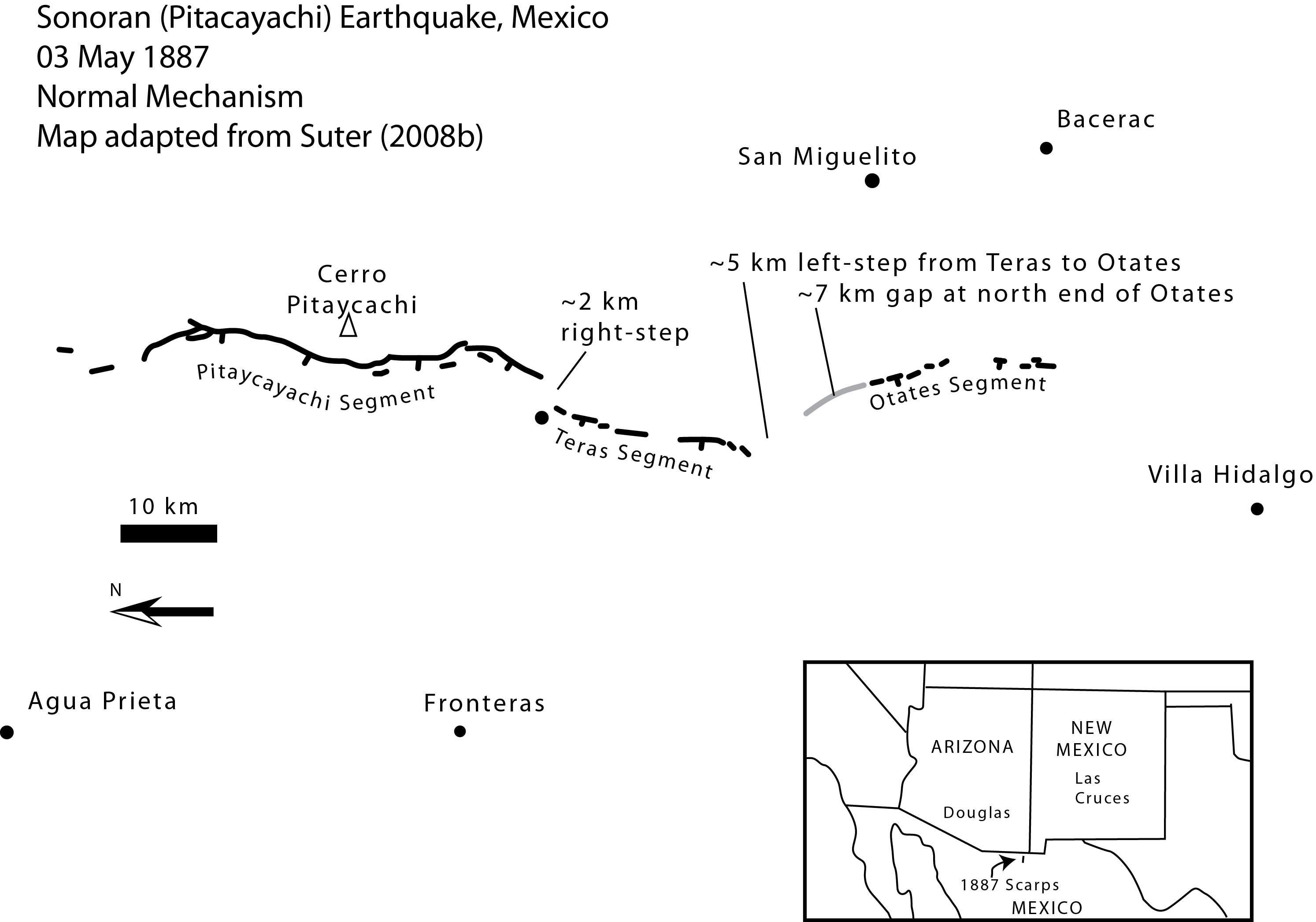
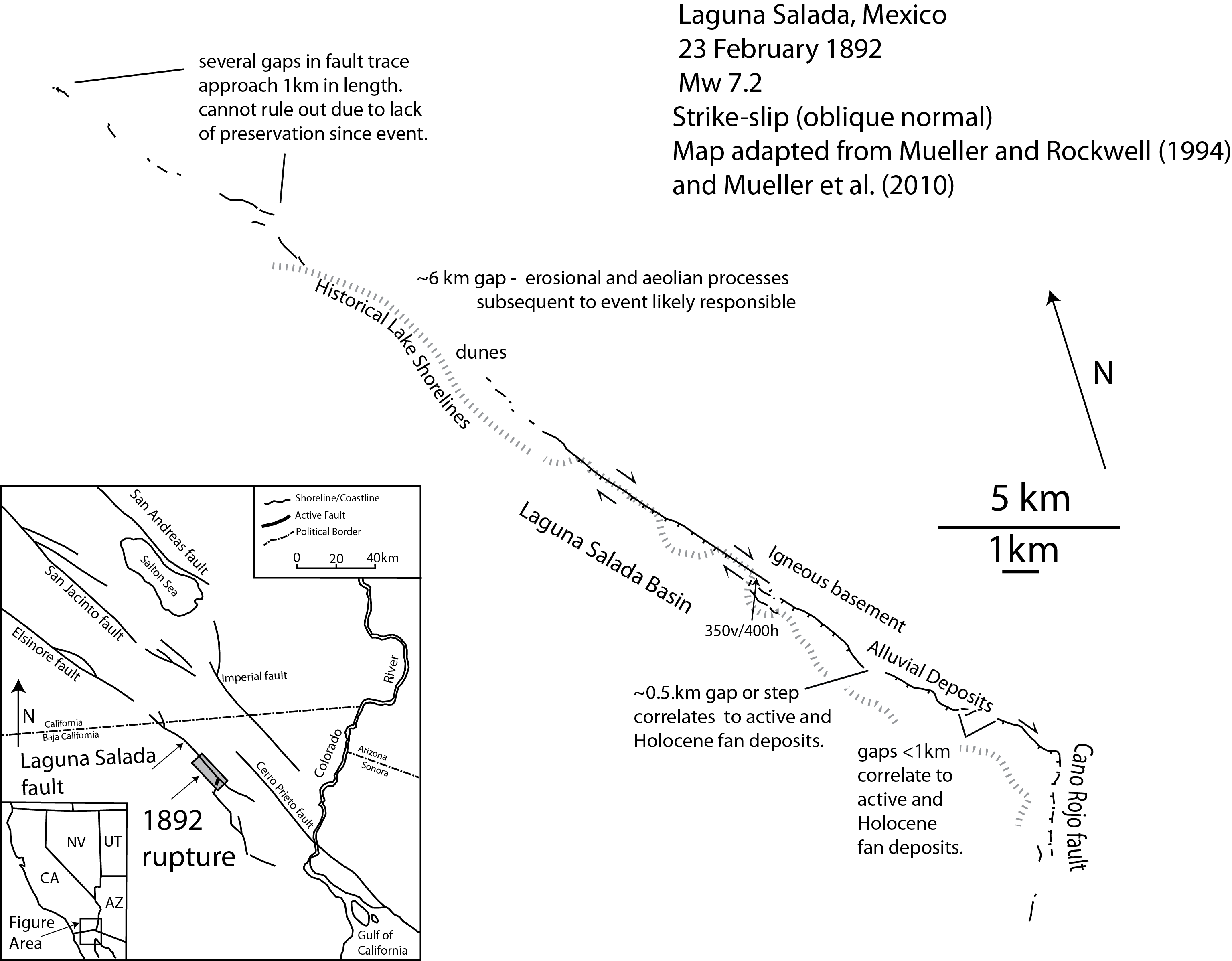
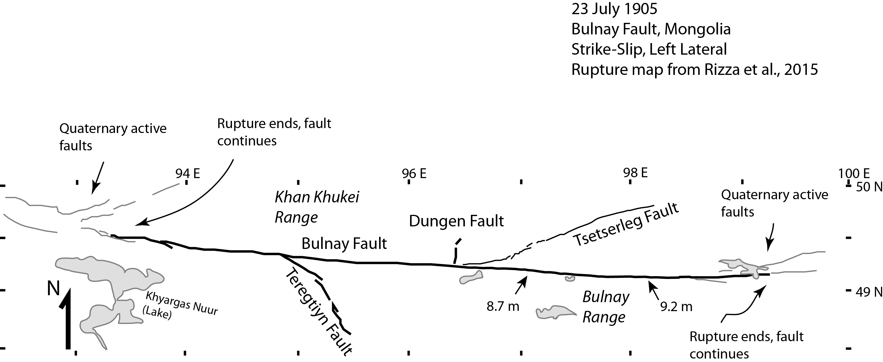
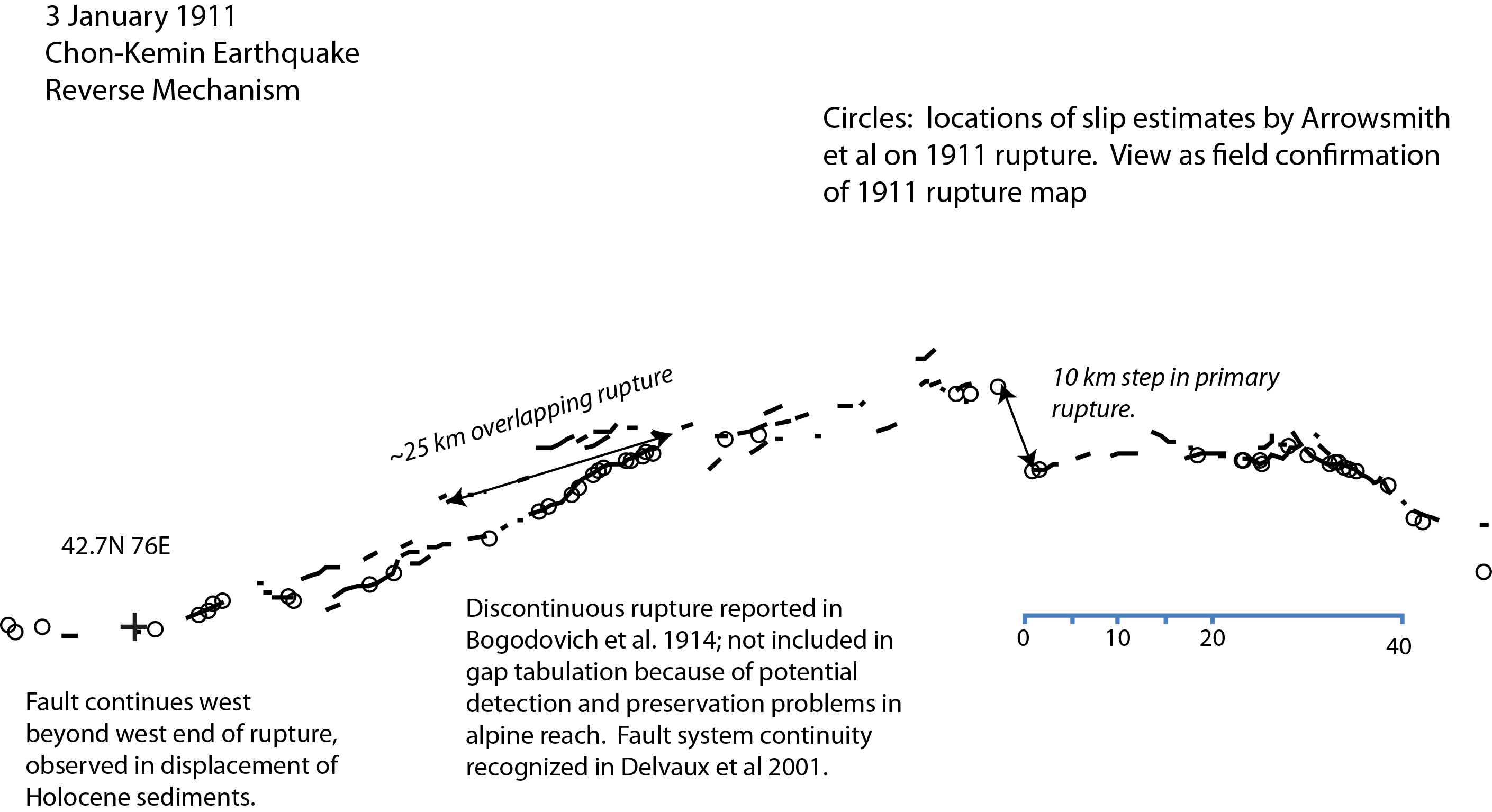
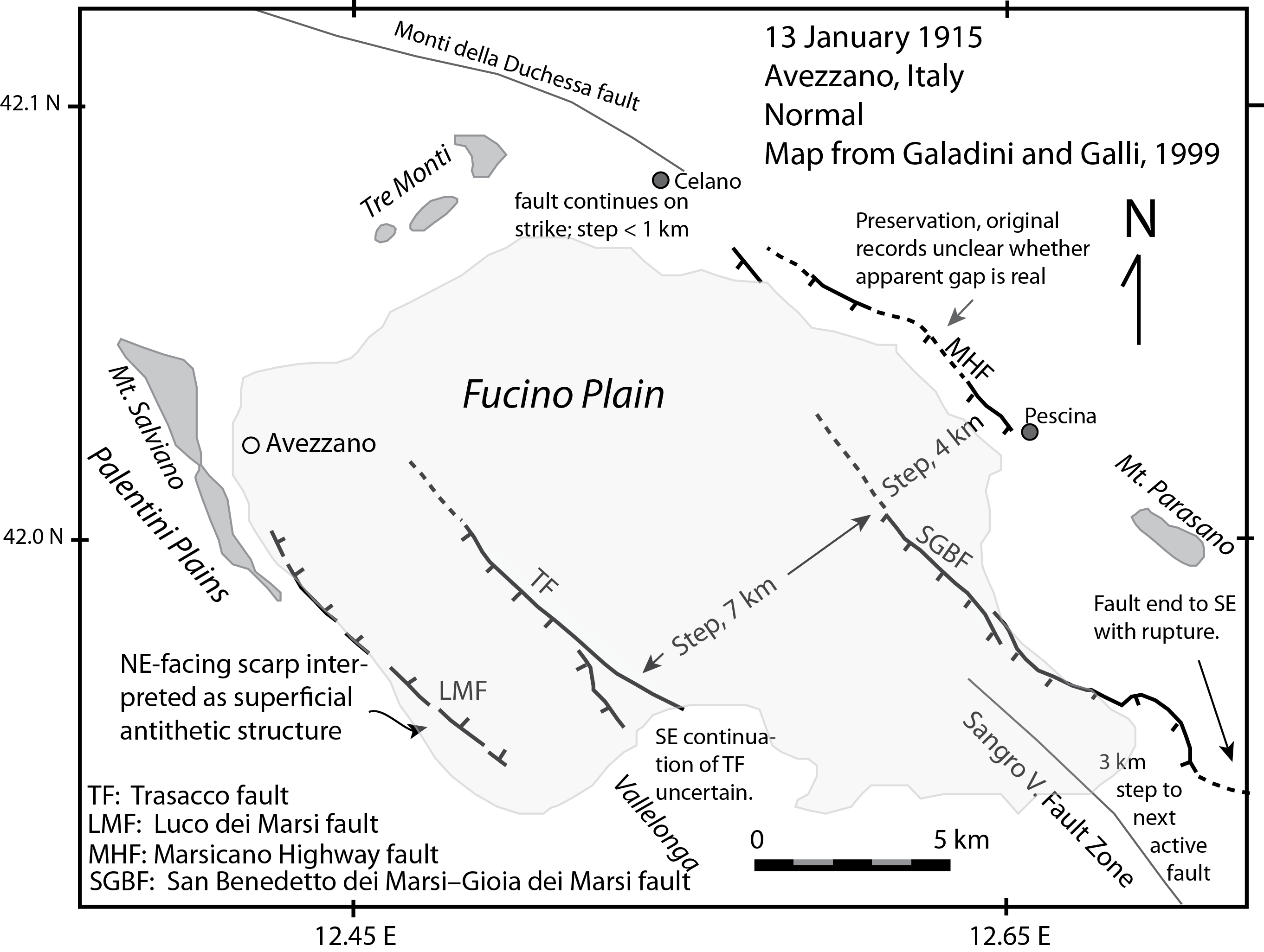
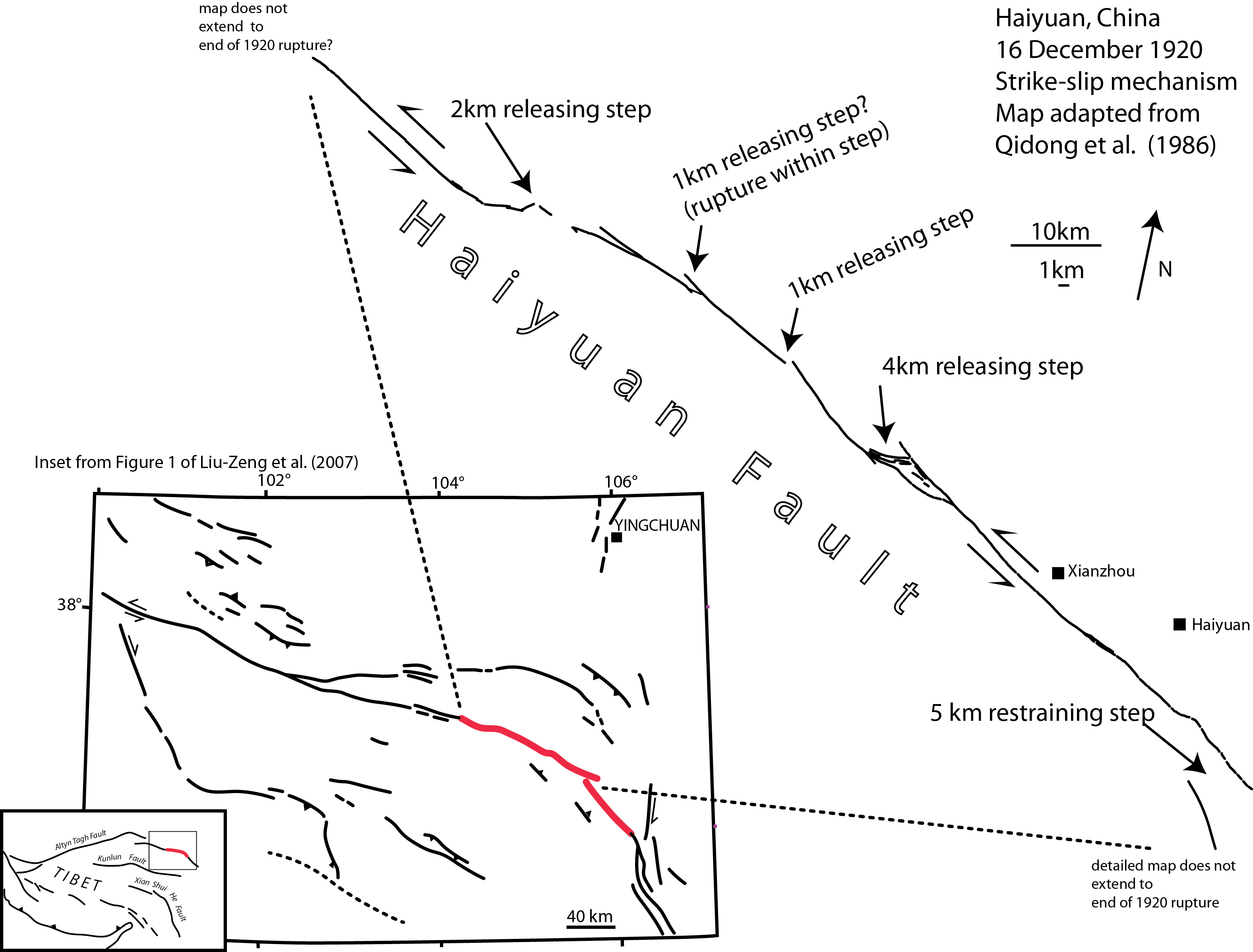
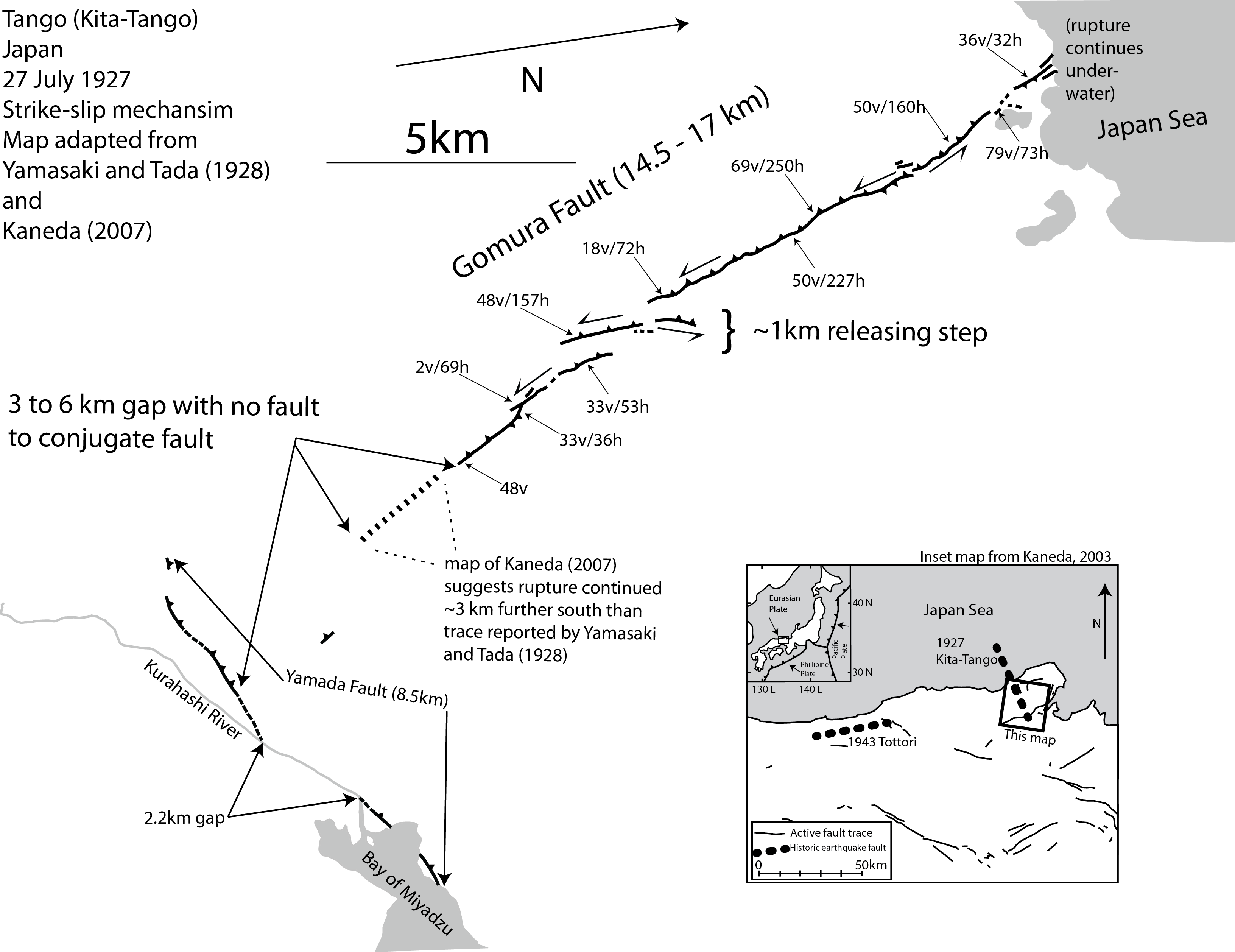
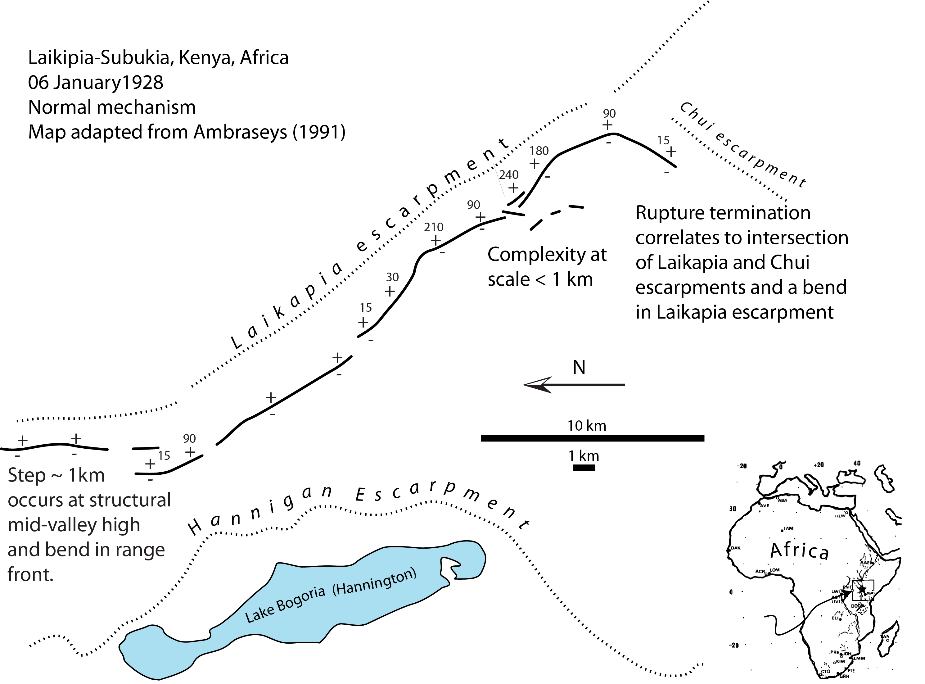
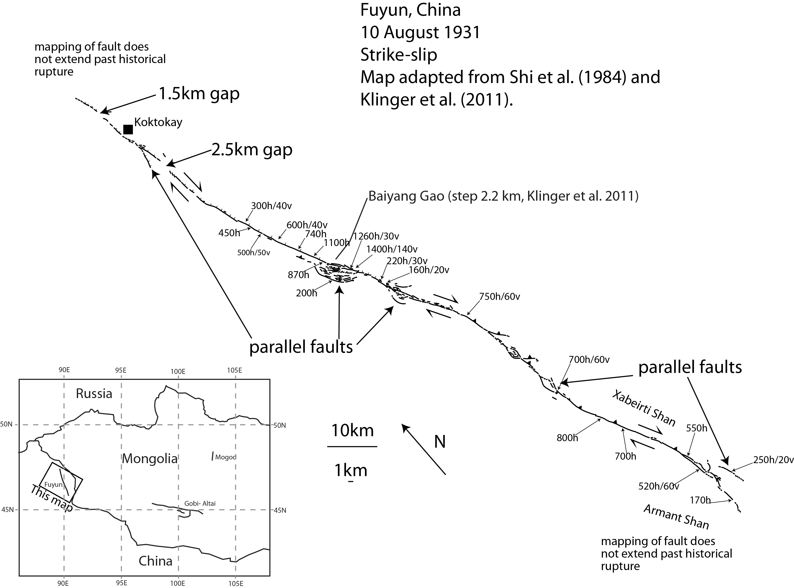
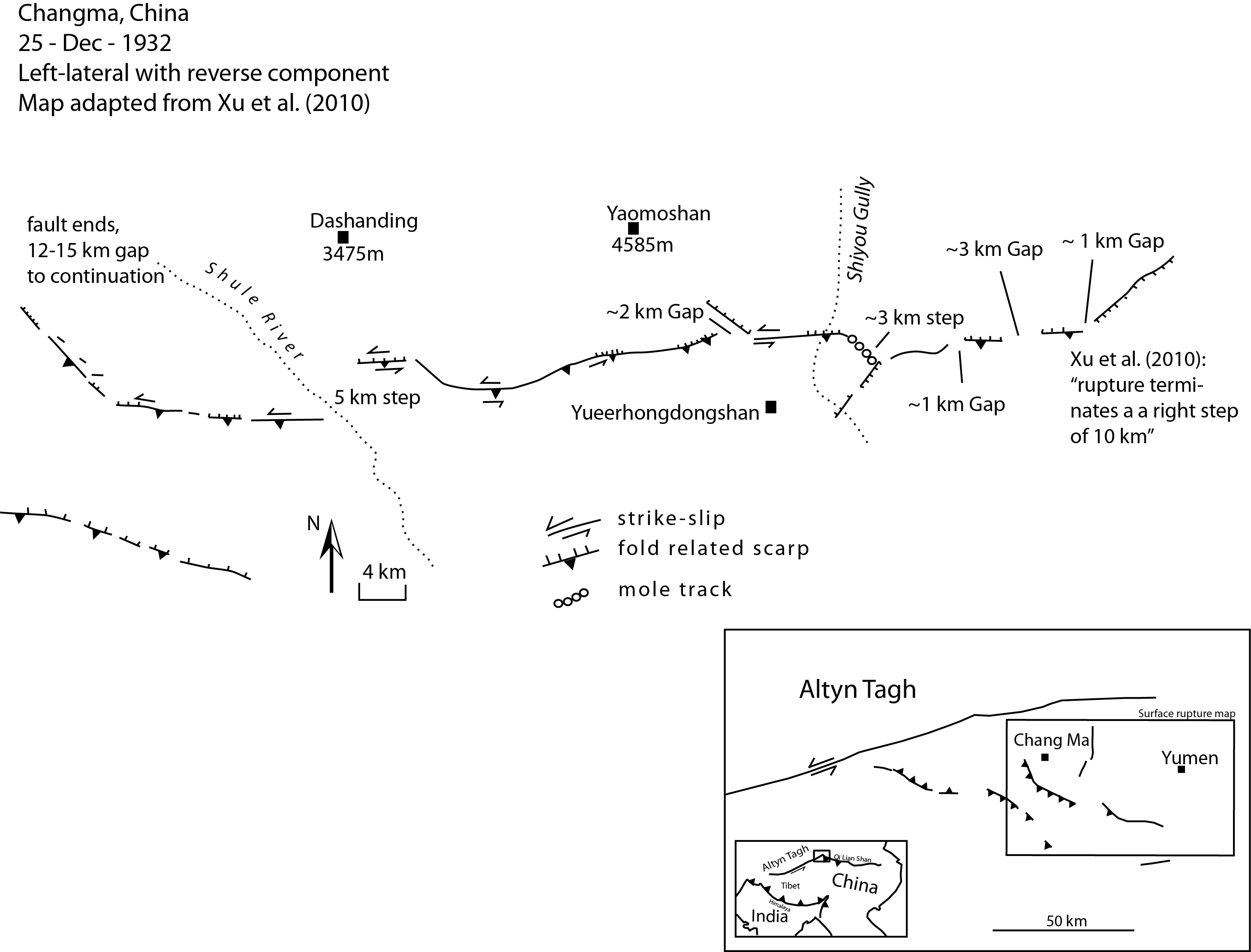
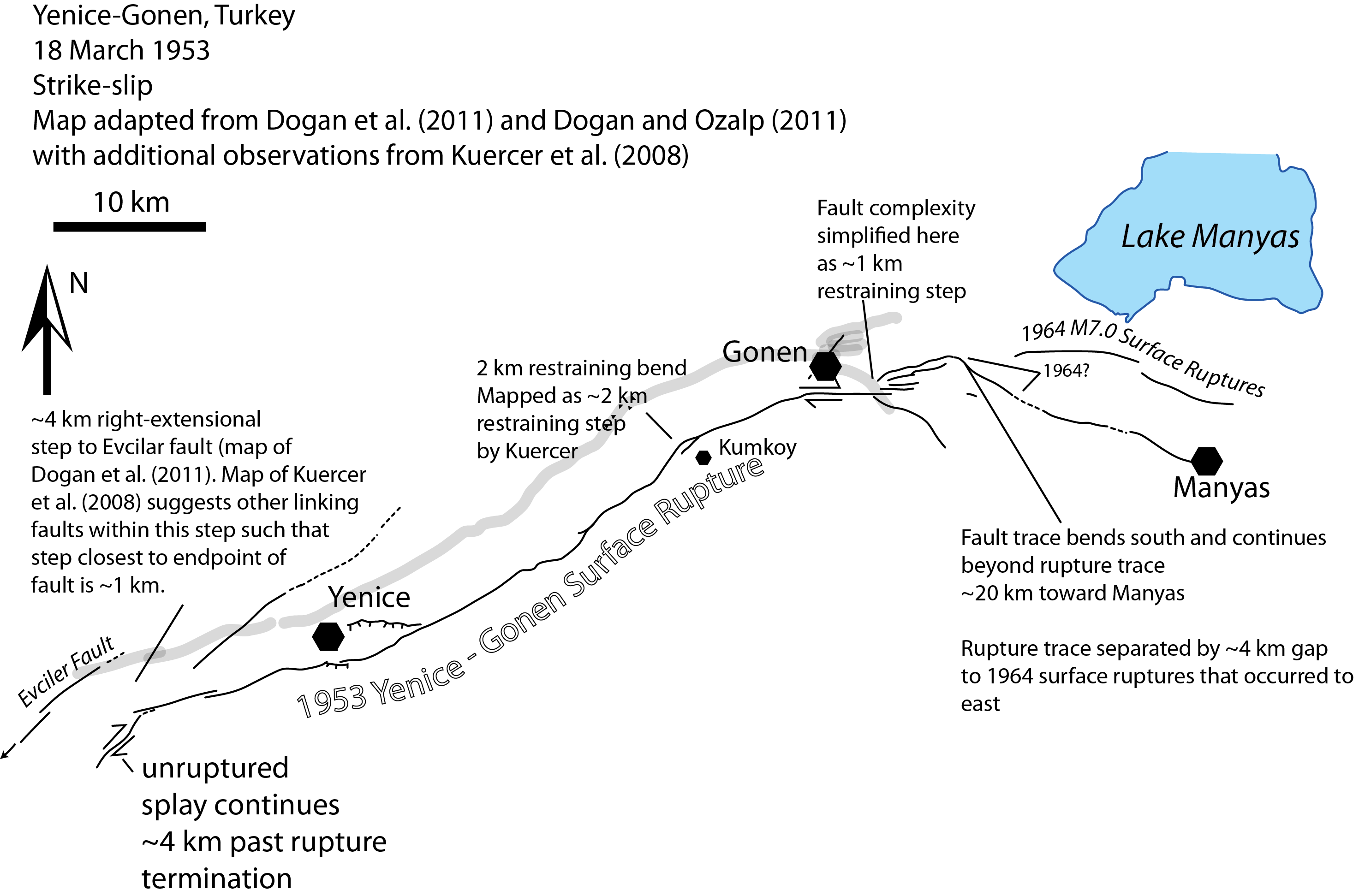
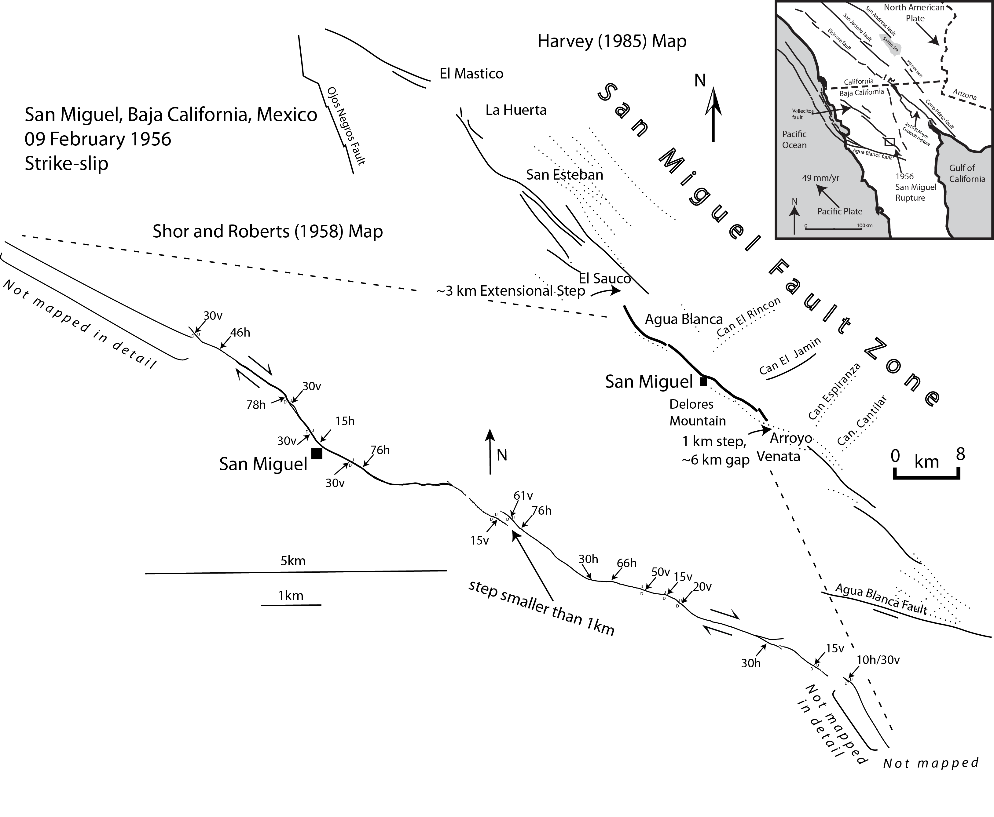
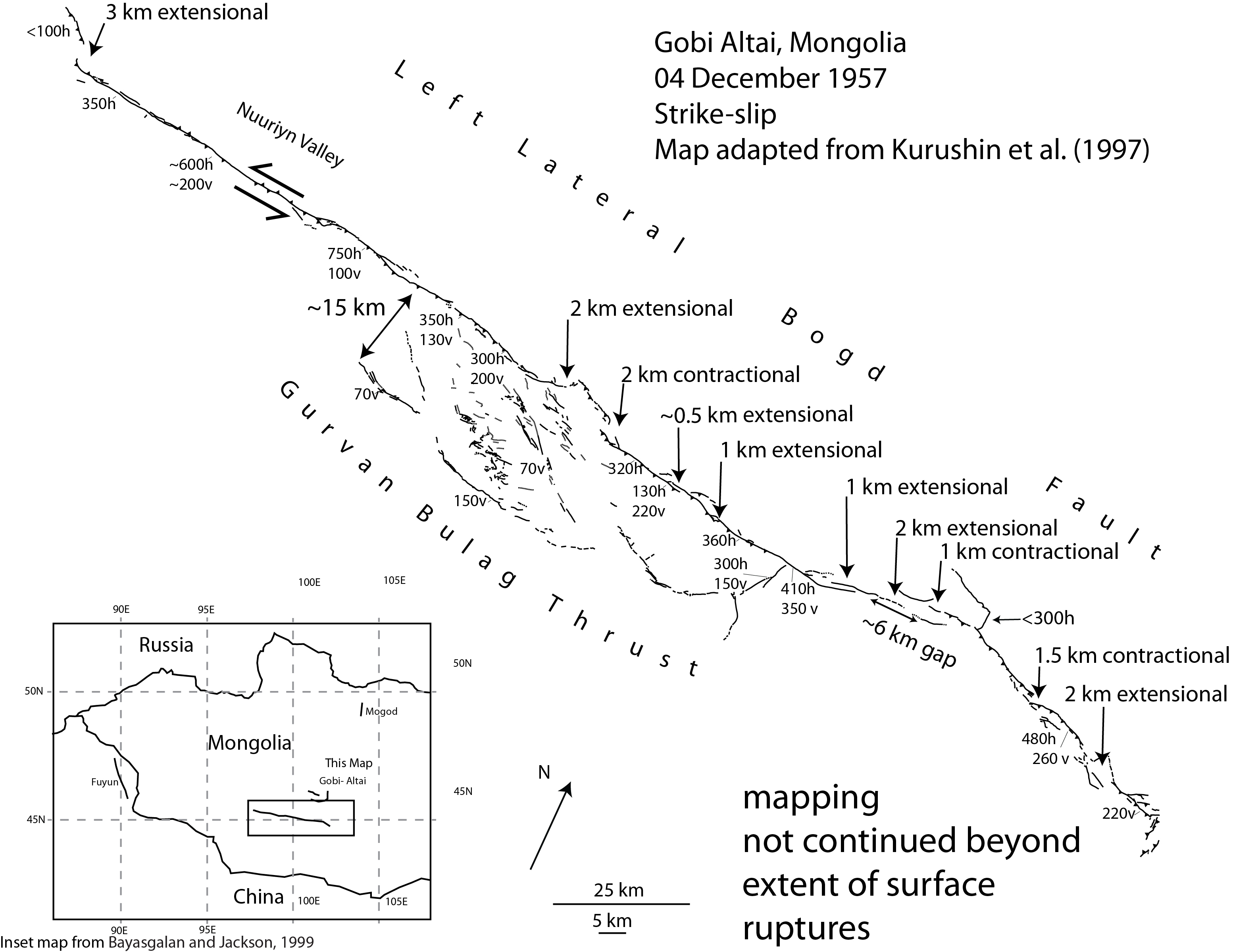
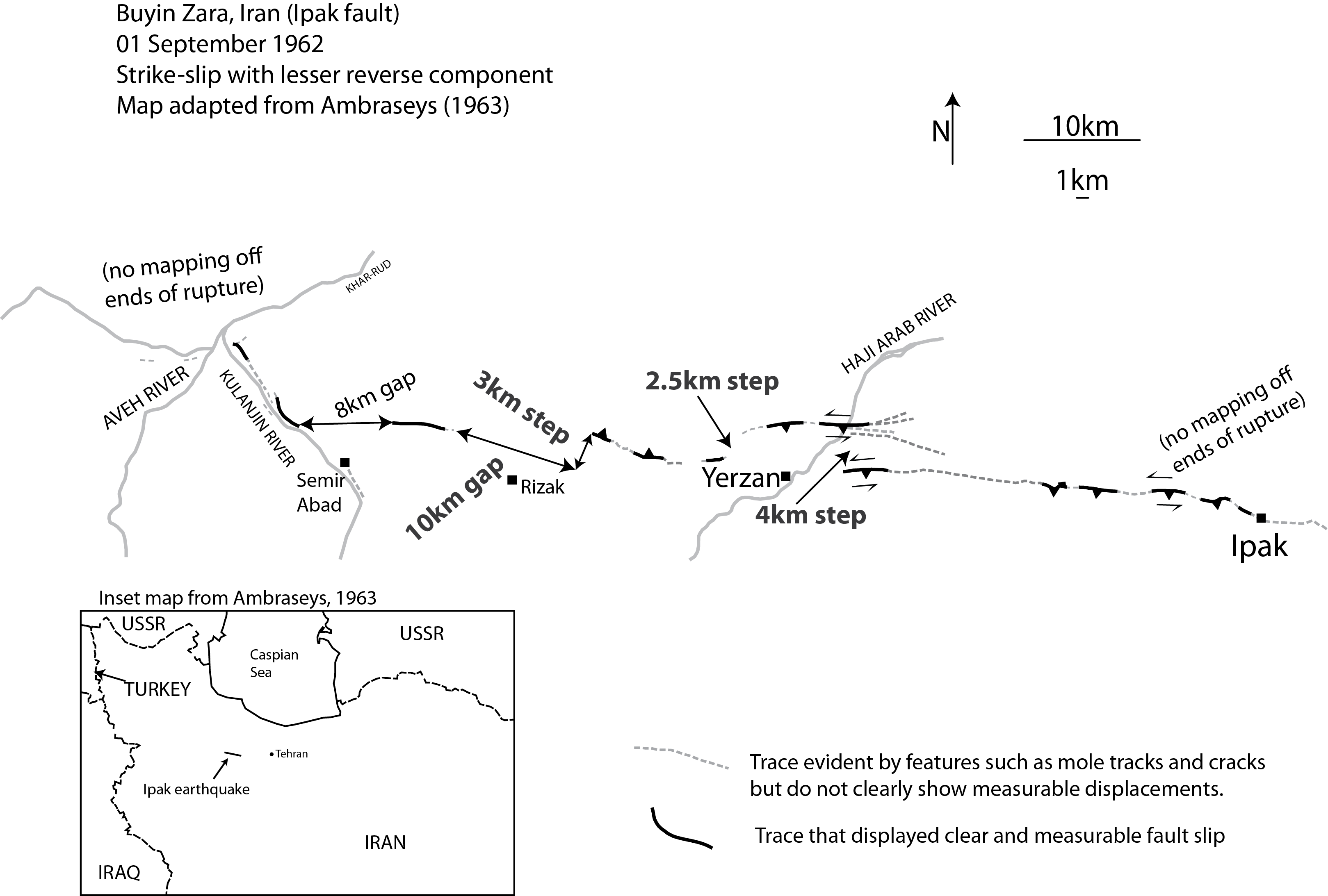
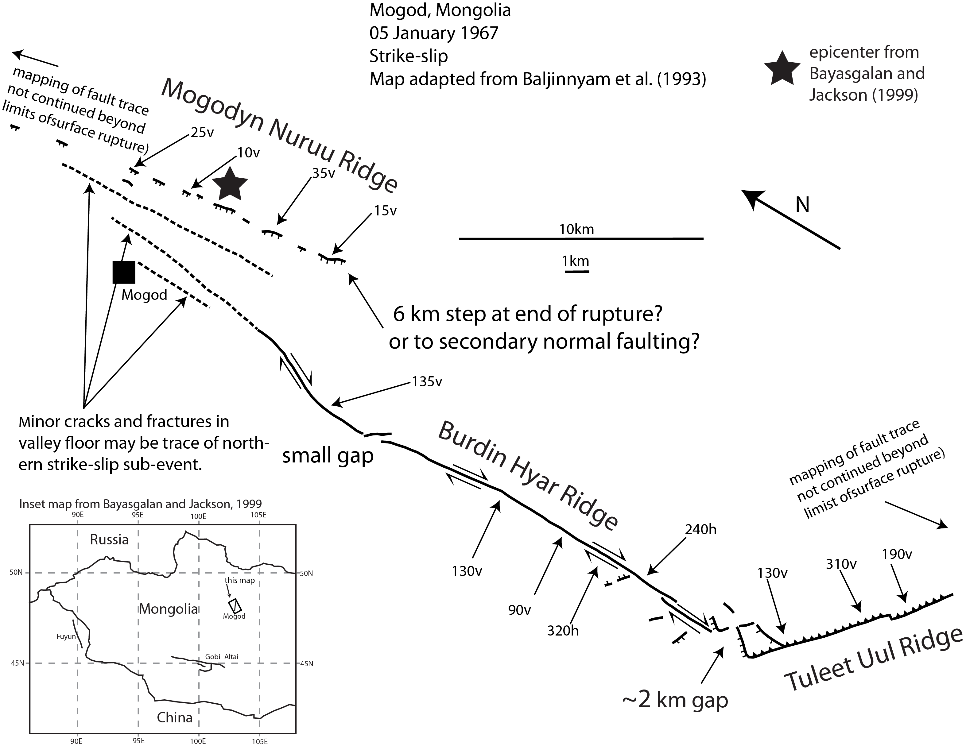
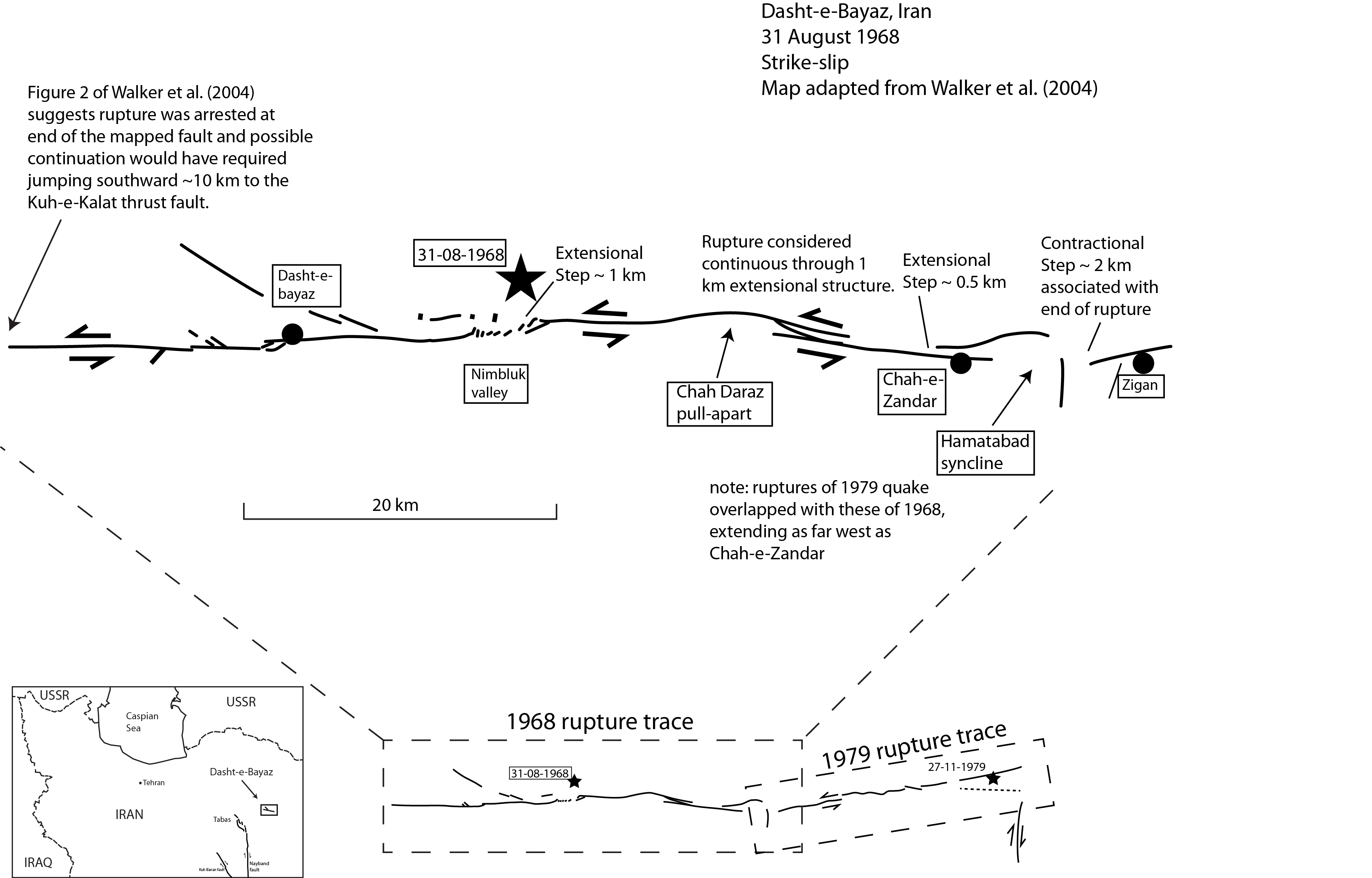
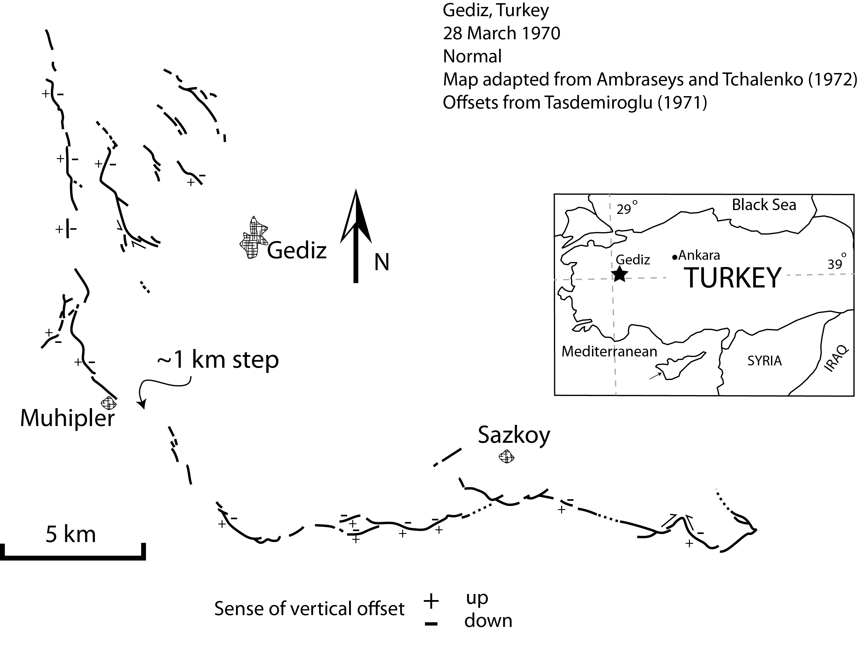
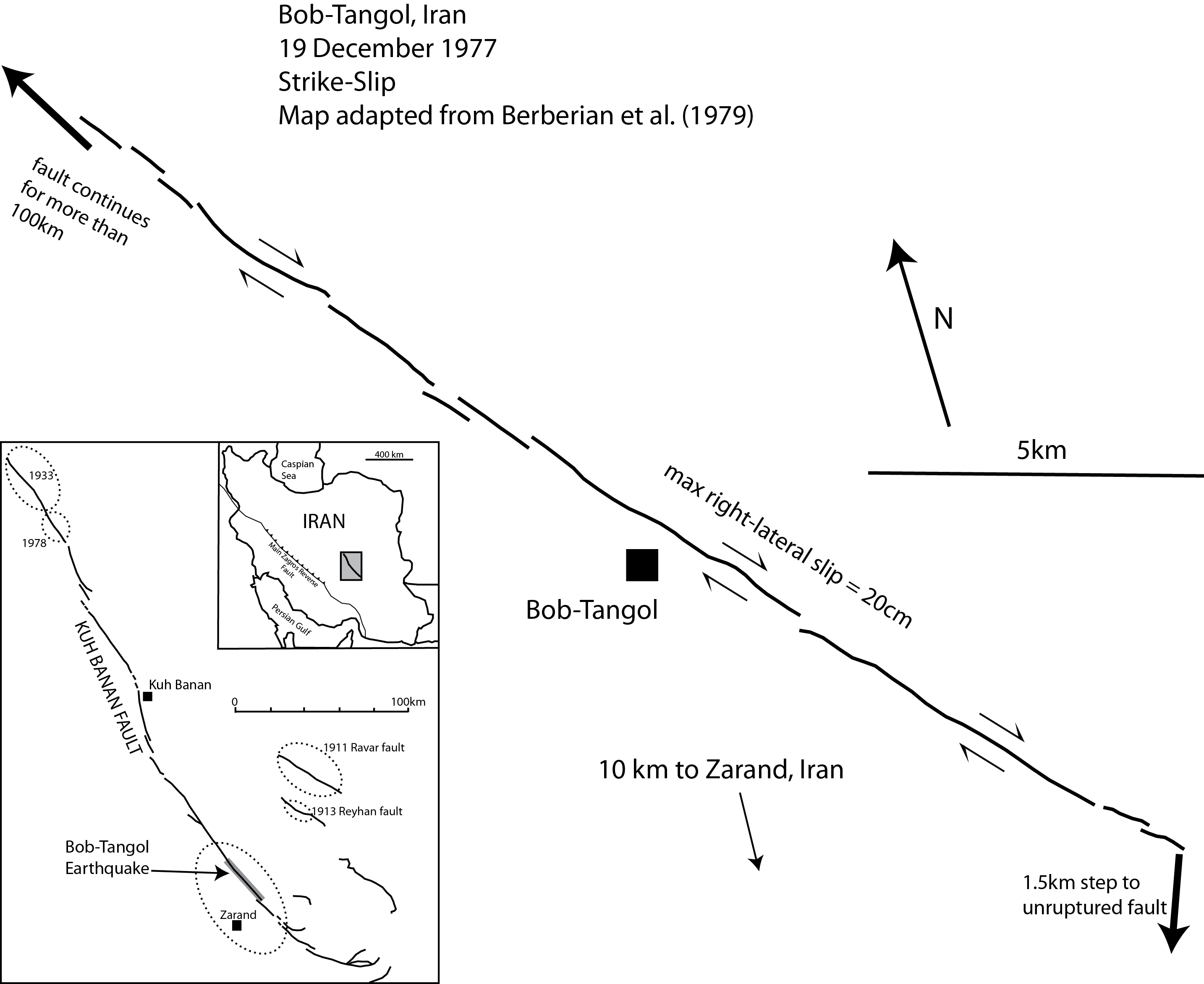
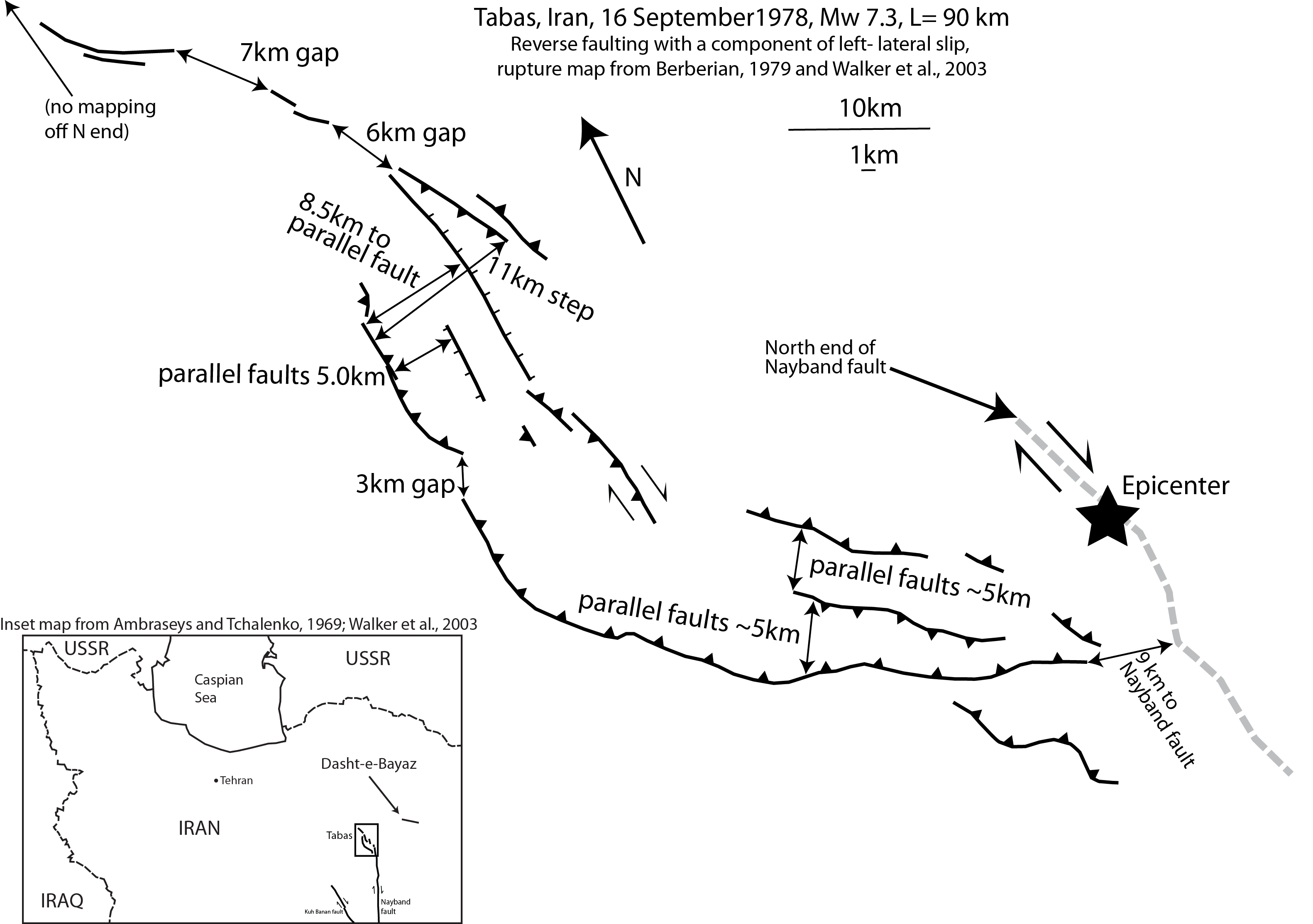
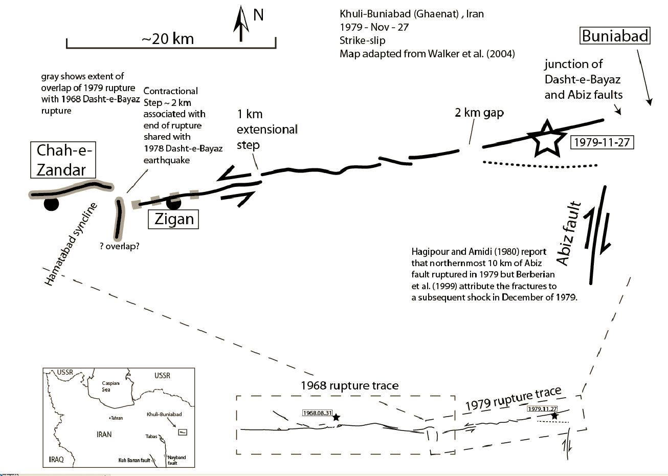
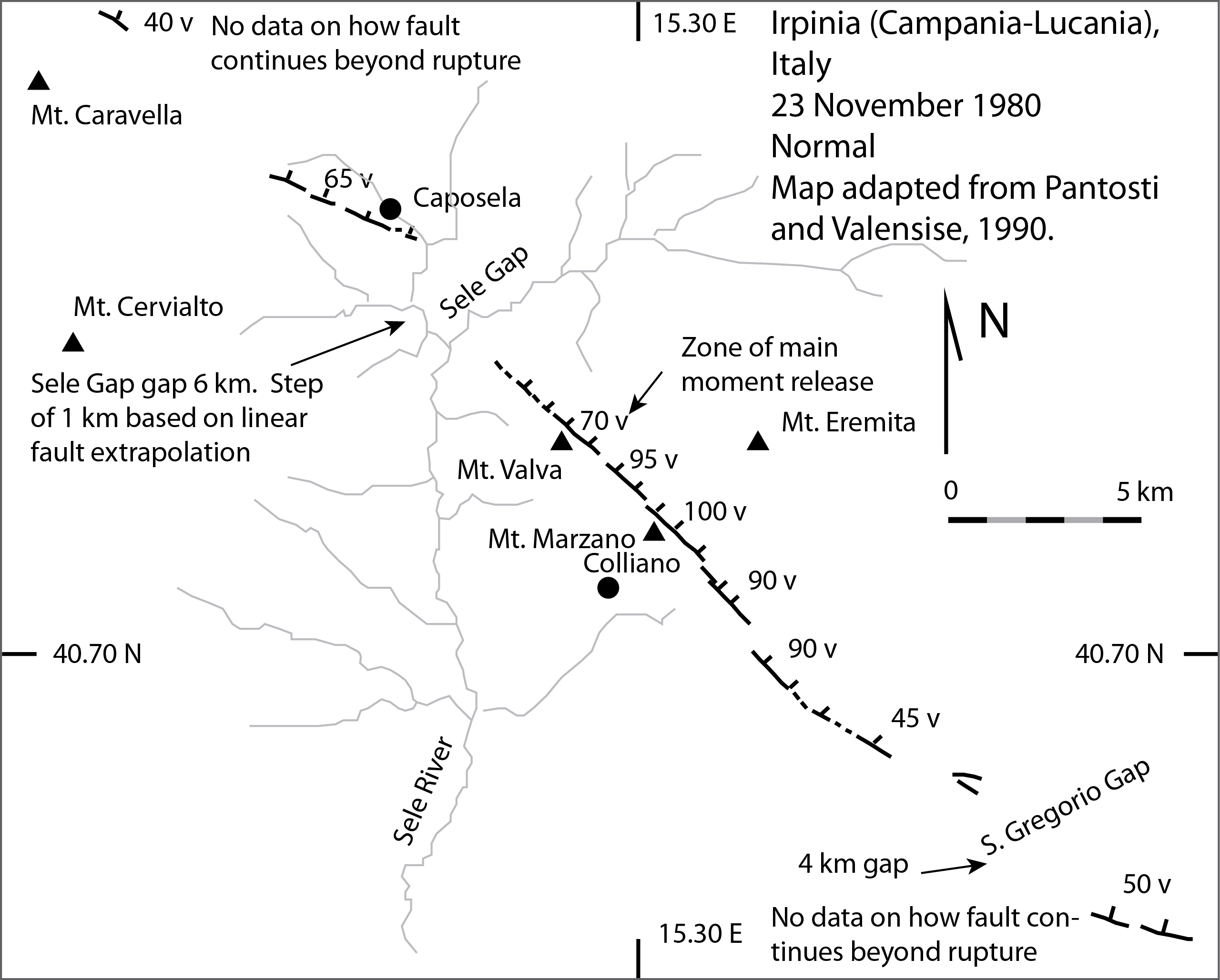
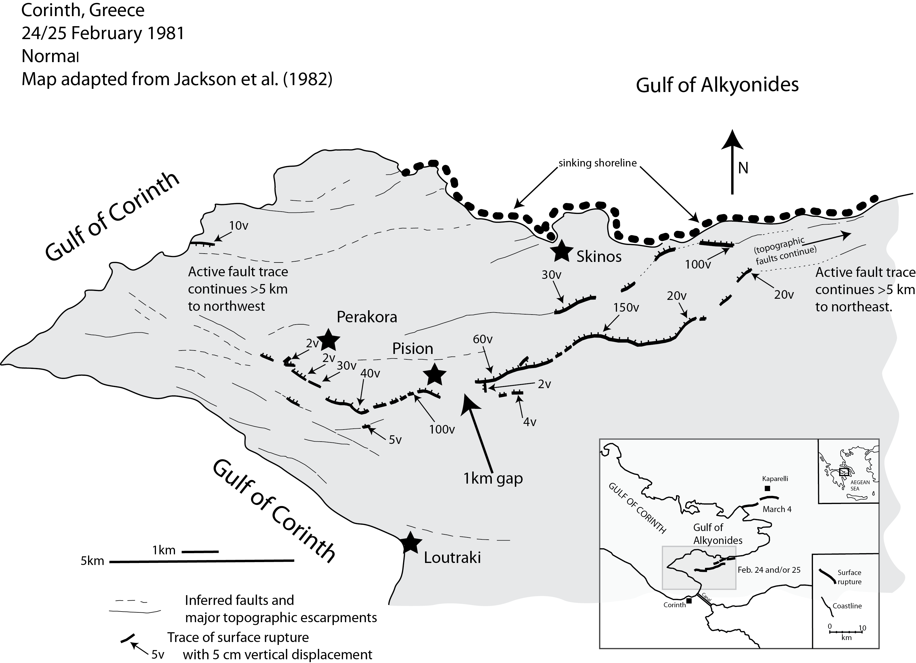
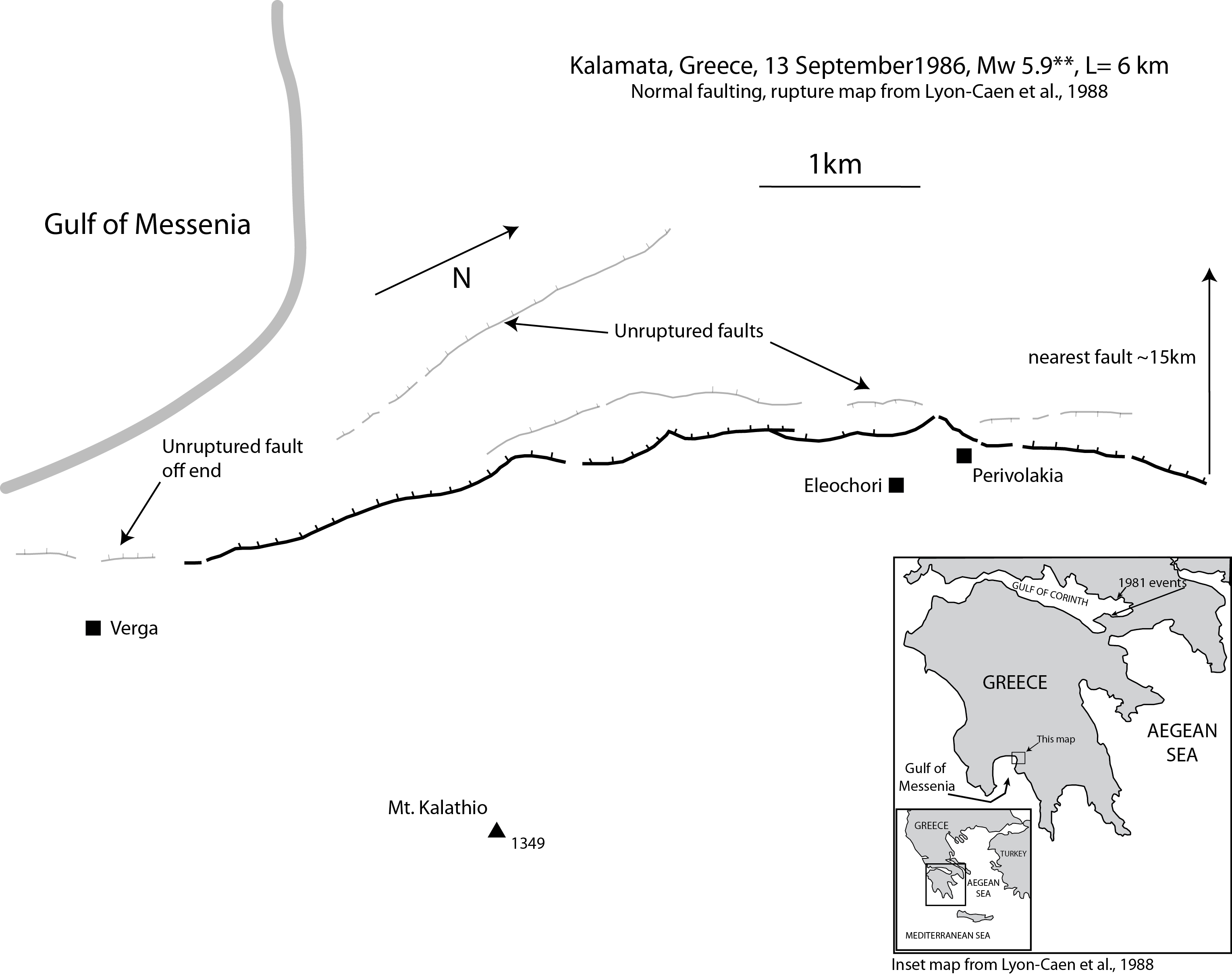
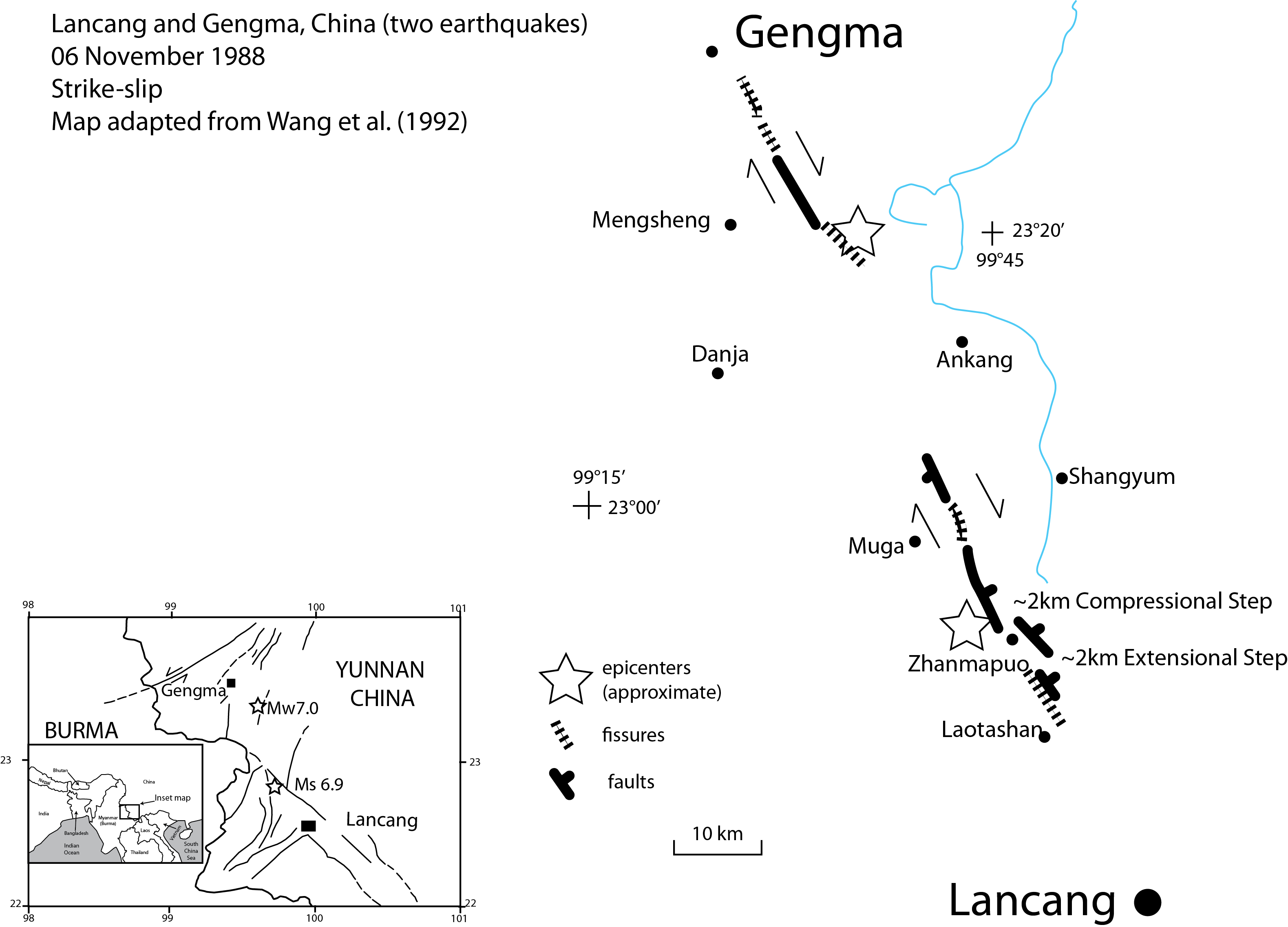
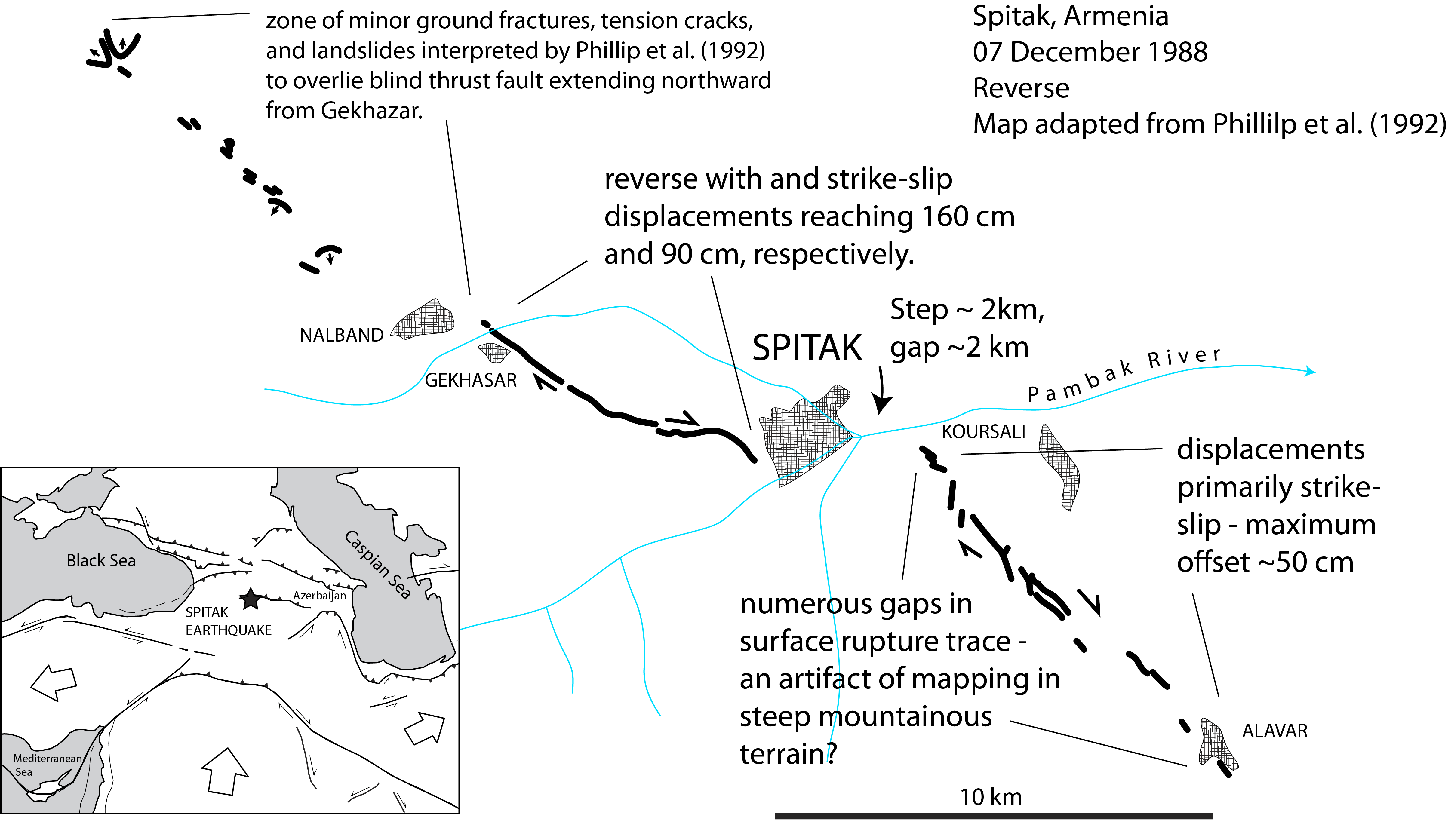
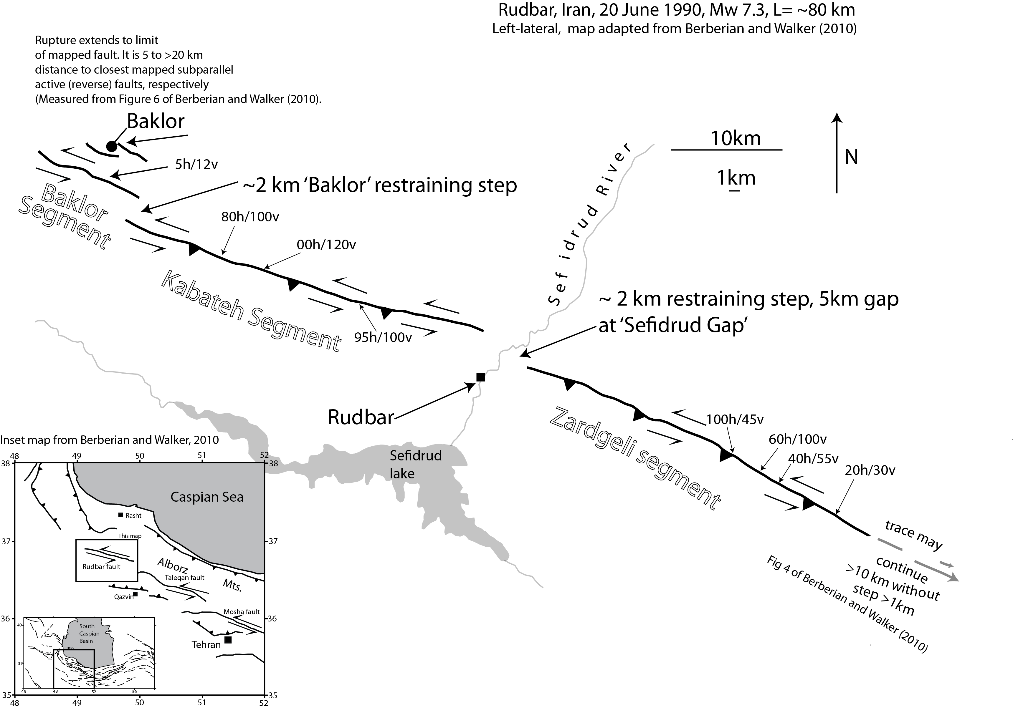
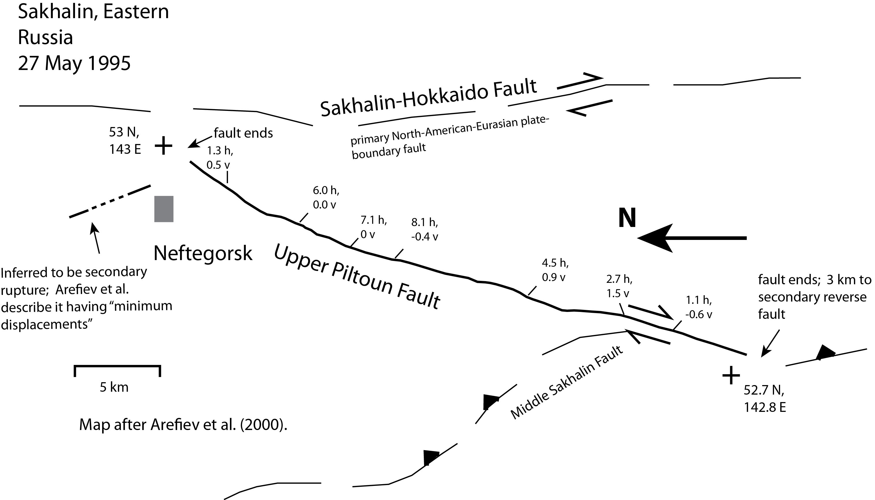
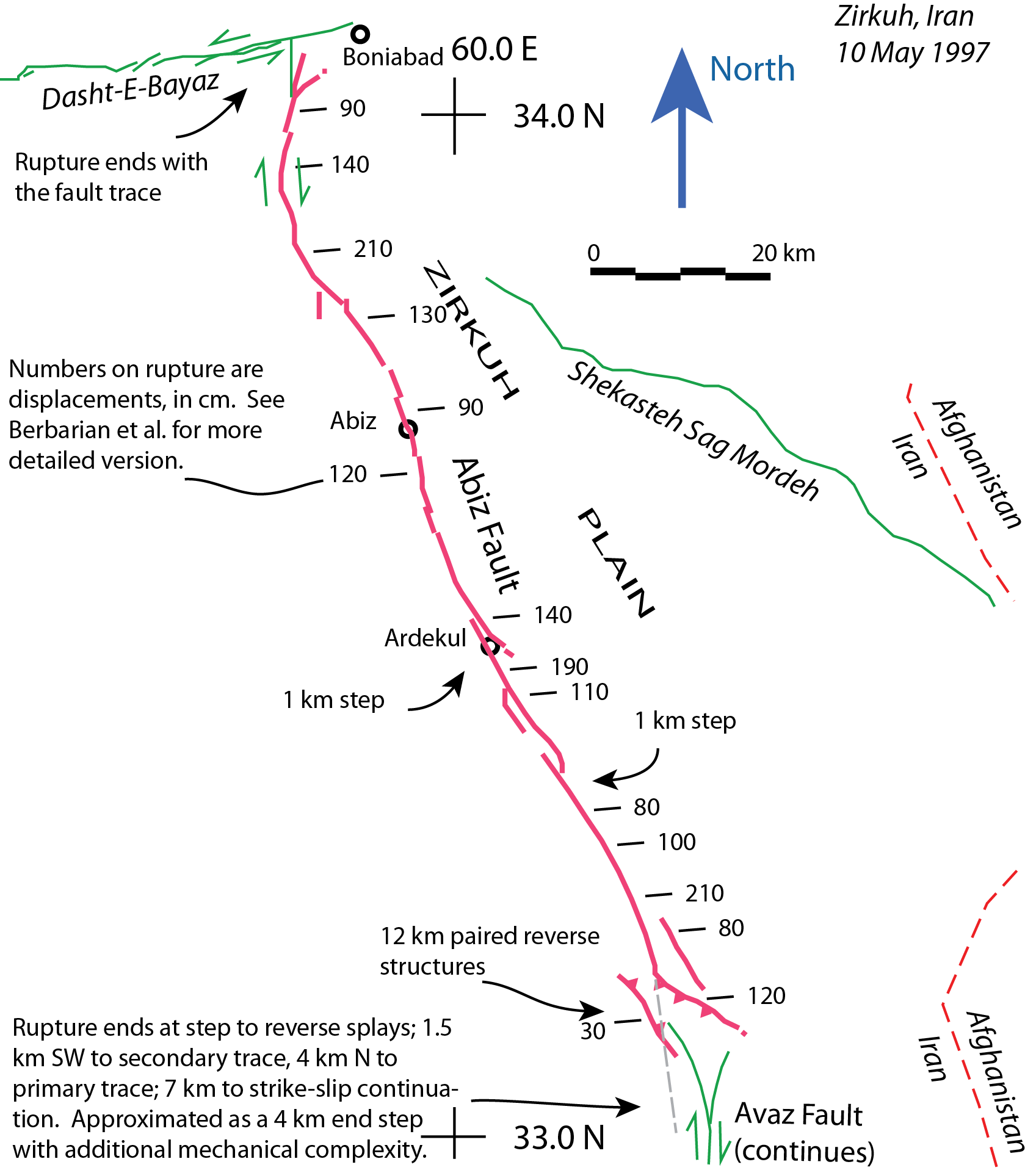
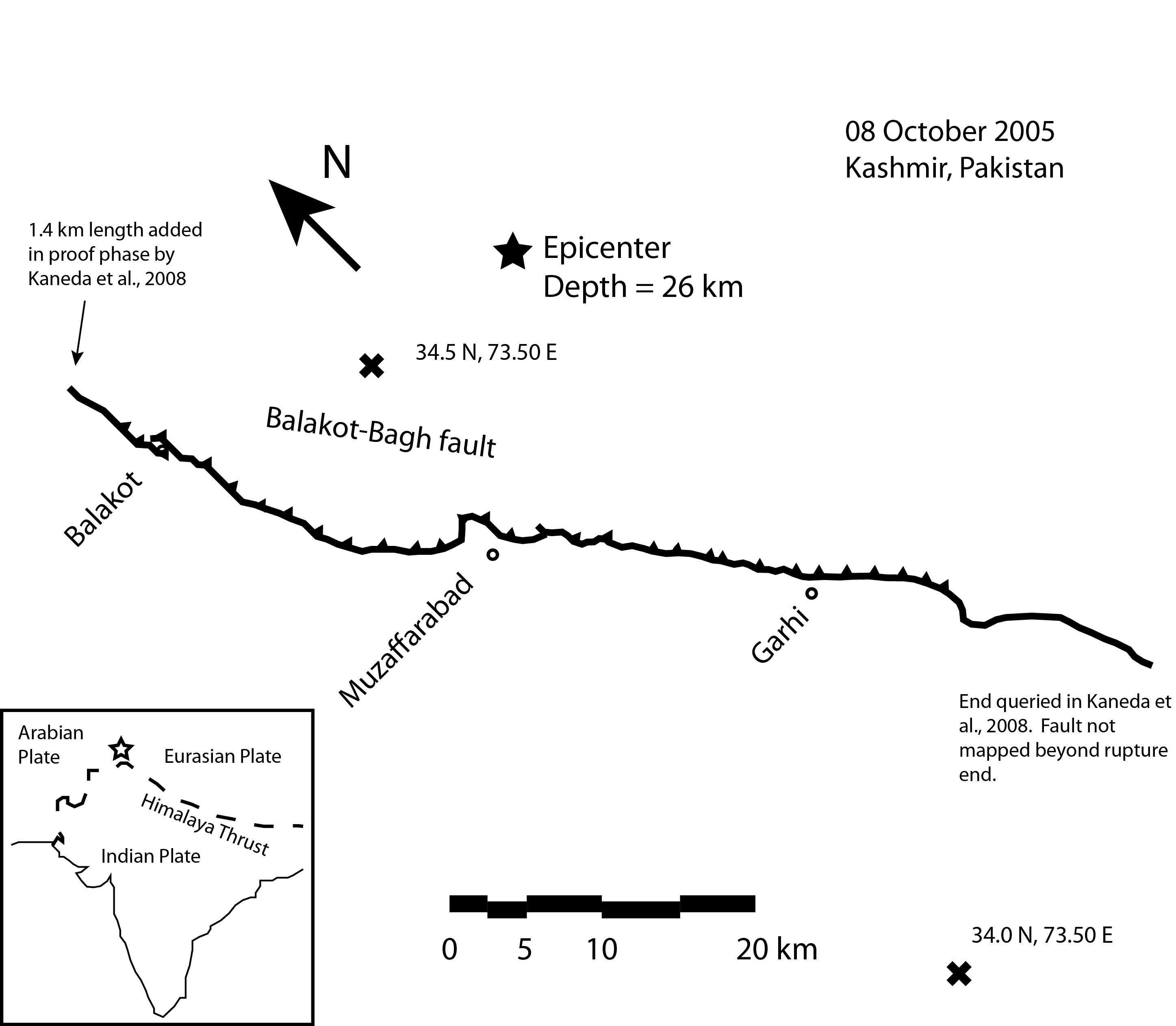
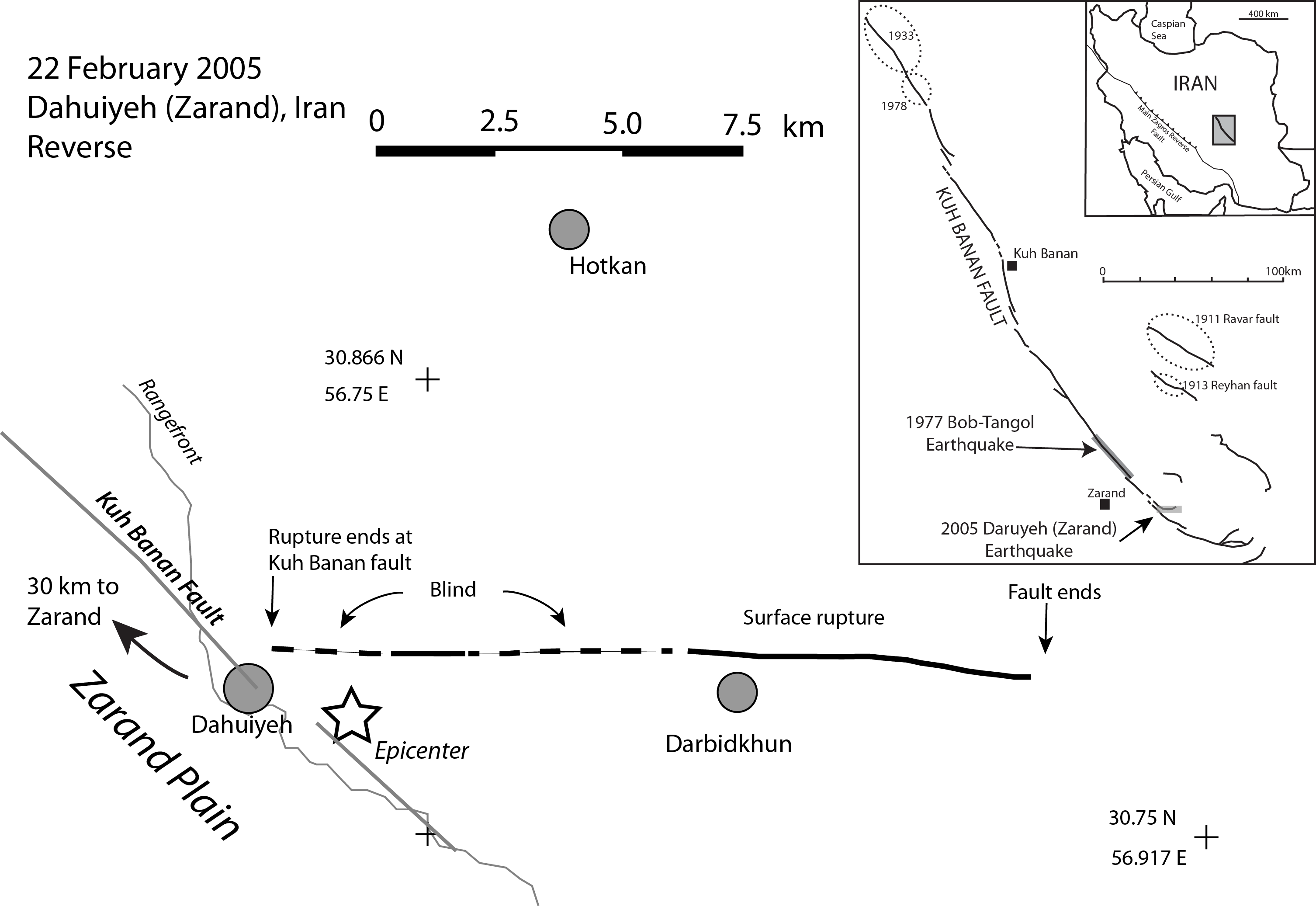
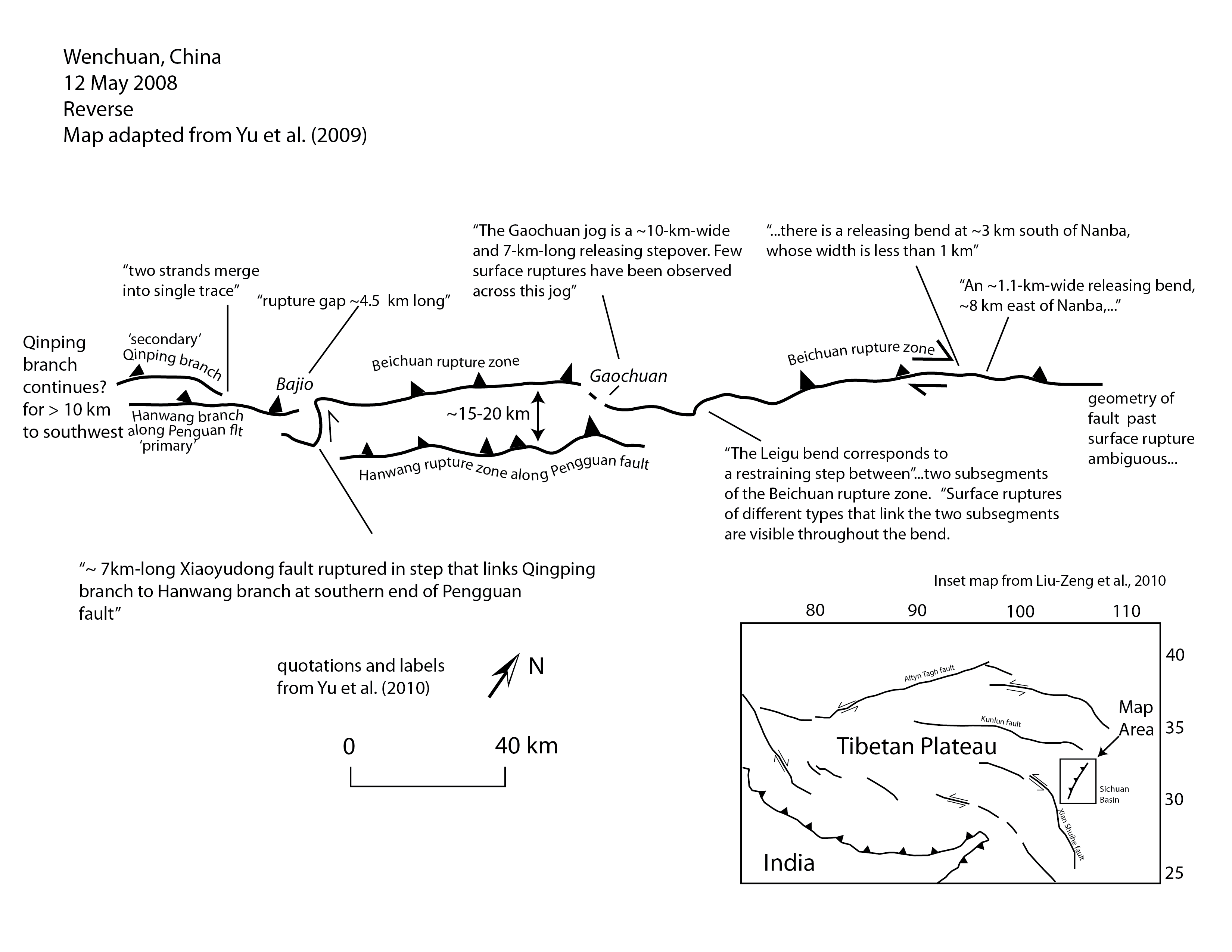
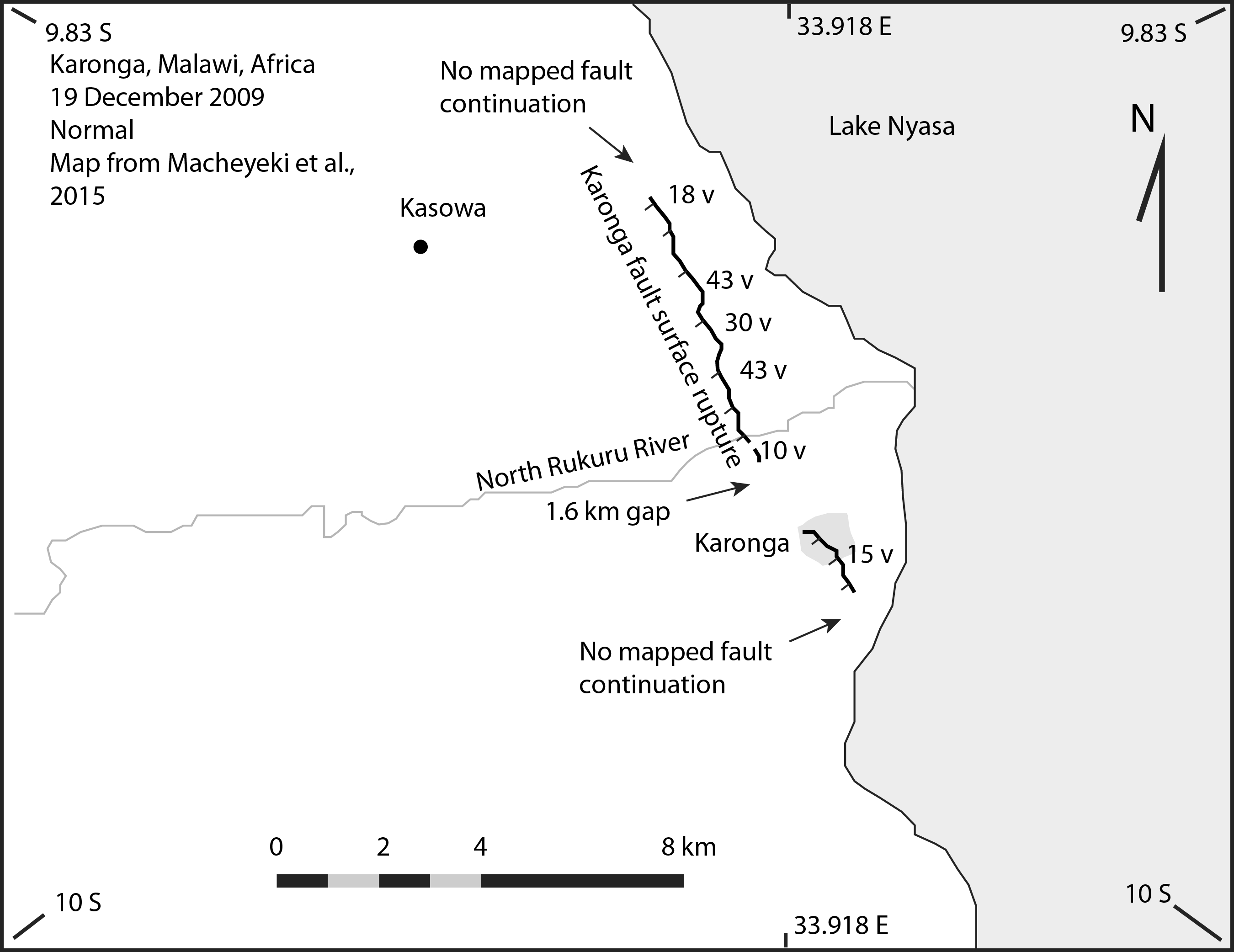
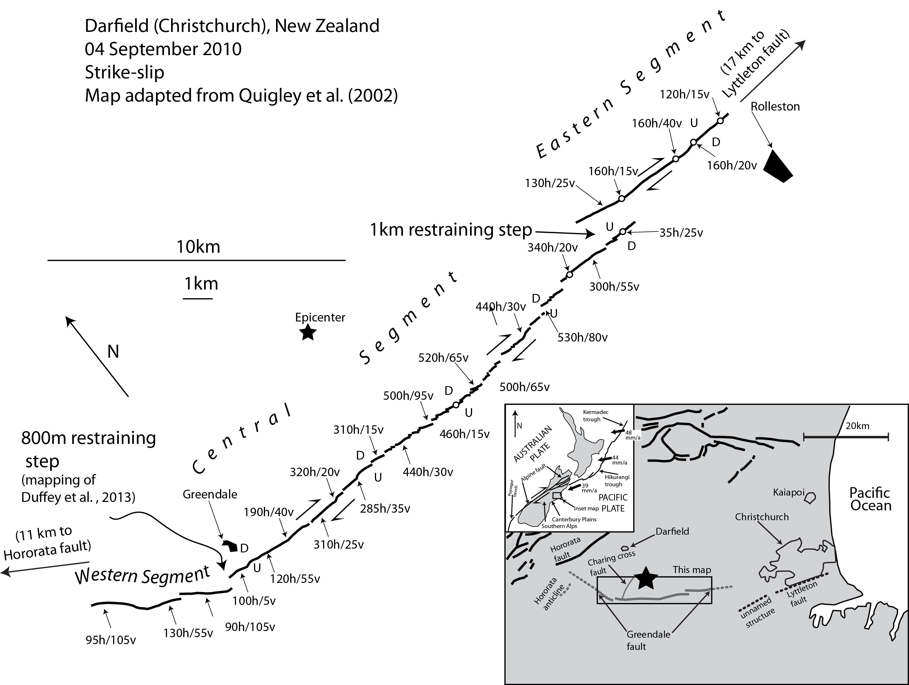
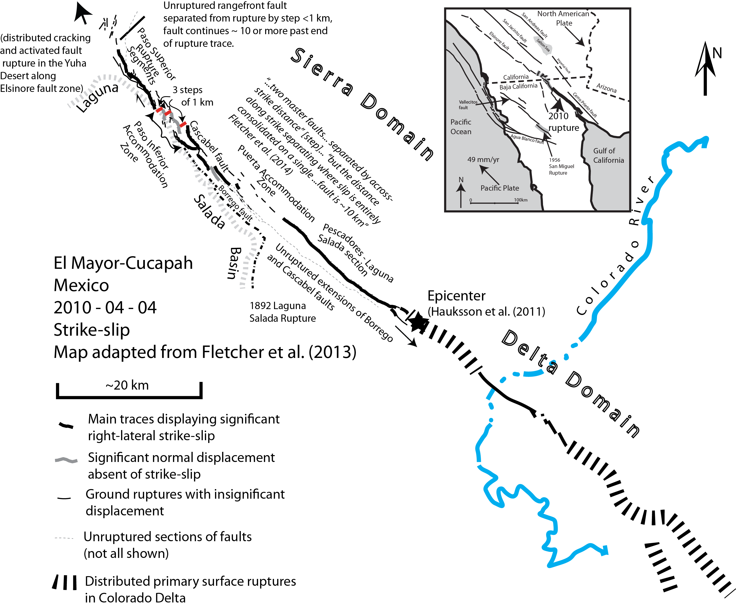
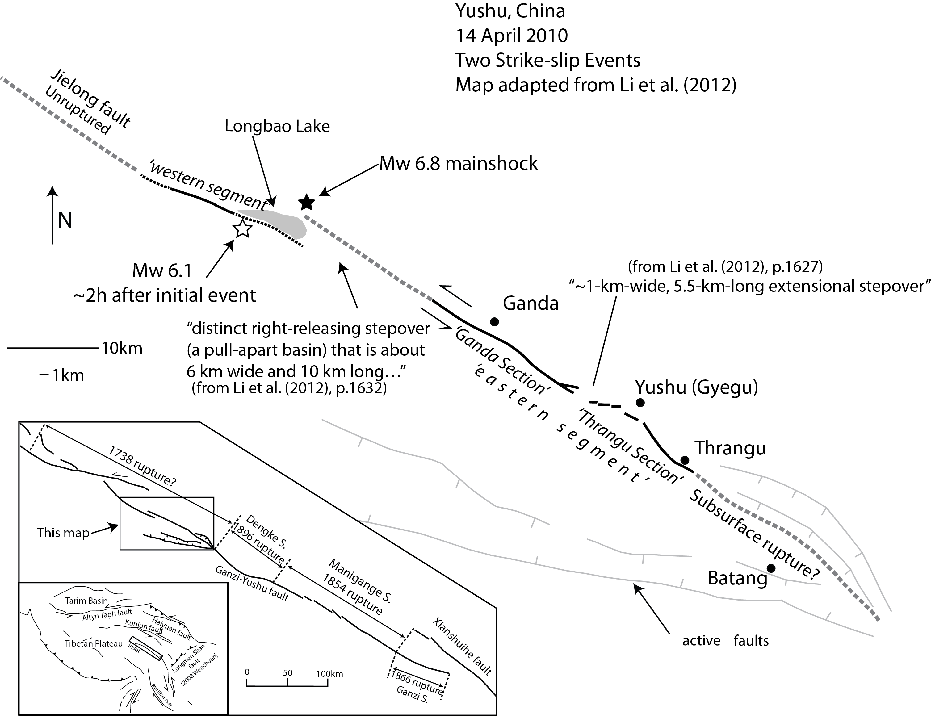
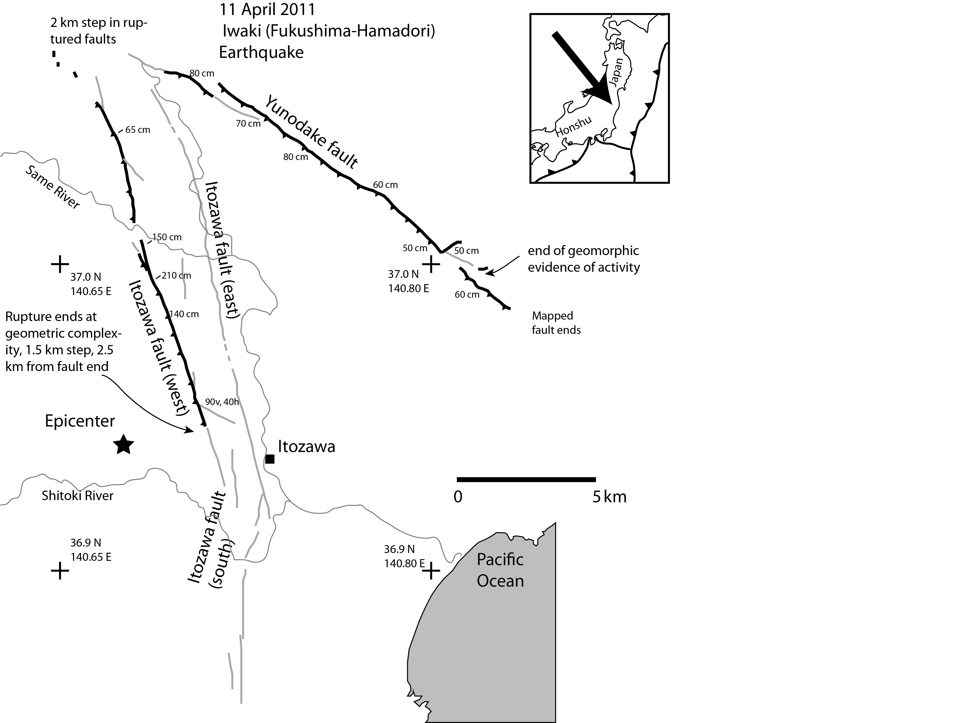
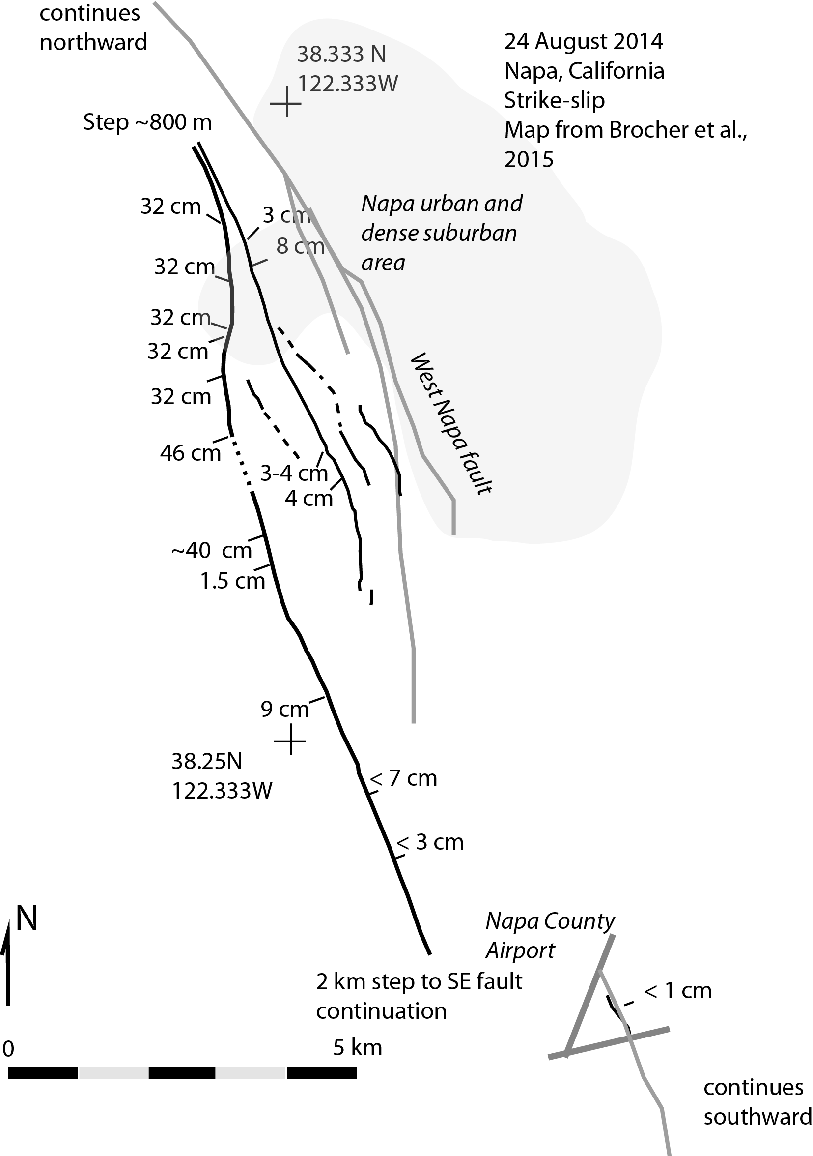