13 March 2018–The way that soil and rock behave during and after an earthquake are studied not just by earth scientists, but by the engineers who must build against the next earthquake. It’s an aspect of seismology that isn’t always recognized by the public, says University of Texas at Austin Professor Ellen Rathje.
Rathje is a geotechnical earthquake engineer, meaning that she focuses on how the ground underneath everything, from buildings to roads to dams, moves in response to seismic waves. “The way I like to think of it is that I work where seismology and ground motions come in and feed into the infrastructure,” she said. “I research things like how the near-surface soil and rocks influence the level and the characteristics of ground shaking, which is a very important phenomenon that can impact the amount of damage that can occur.”
Her interest extends to the “secondary” geohazards that ground shaking can cause, such as landslides and liquefaction. Landslides occur when the shaking is strong enough to move a slope downhill and liquefaction is a process where strong shaking can reduce the strength of saturated and loose soils and turn them into a substance more jelly-like than solid. “We are looking at how we can better predict these kinds of geohazards, and how we can design against them.”
As part of this effort, Rathje serves as the principal investigator of the DesignSafe cyberinfrastructure project, the cloud computing platform that offers researchers data analysis and visualization tools to work on infrastructure engineering problems related to earthquake, tsunami and other natural hazards.
Rathje has plenty of raw data to use when testing out different prediction techniques and models. She is also the current co-chair of the Geotechnical Extreme Event Reconnaissance Association (GEER), which deploys geotechnical engineers around the world after major earthquakes (and more recently other natural disasters such as floods) to collect data on ground motions and secondary effects like landslides and their impacts on infrastructure.
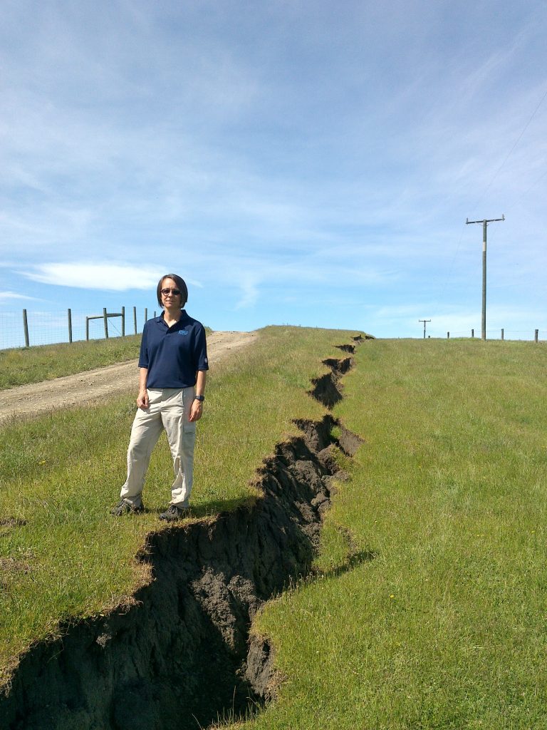
On the ground after the 2016 Kaikoura earthquake in New Zealand, as well as the Haiti earthquake in 2010, Rathje worked with teams to “collect data that we can use to inform the evaluation techniques we have, especially when there are engineering lessons to be learned and applied to” infrastructure in the United States.
Remote sensing techniques, including satellite imagery to make measurements of horizontal ground movements, have given geotechnical engineers “a new way to collect data to understand liquefaction movements,” she says.
“I didn’t know anything about [remote sensing] when I finished my Ph.D. 20 years ago, but now I’m helping create new datasets in ways that no one had thought about,” says Rathje.
When she traveled to Kaikoura in 2016, she and her colleagues used high-resolution optical imagery freely available from the U.S. Geological Survey to develop a preliminary map of landslides “in less than a week” she marveled. The researchers also used tablets on helicopter rides over the region “where we could see where we were on the map on our tablets, and in almost real-time we were able to evaluate our landslide map.”
“These are the kinds of things that have changed [the field],” she says. “Even simple things like the availability of Google Maps and Google Earth. I remember when we went to study the 1999 Izmit earthquake in Turkey, we wanted to map the damage in this city, and we went to city hall and spent half the day trying to get a map out of them!”
“Now, we really go out to the field with a lot more information and we can plan much better,” she adds.
Rathje is the 2018 recipient of the William B. Joyner Lecture Award, bestowed by SSA and the Earthquake Engineering Research Institute (EERI). In her Joyner Lecture for the SSA and EERI Annual Meetings, Rathje will discuss some of her “wish list” items for geotechnical earthquake engineering, including use of engineering analyses over a regional scale of hundreds of square miles, and the need for more instrumentation to observe secondary earthquake effects.
It’s difficult to predict where these effects might take place, she admits, “but I think being able to well-instrument a site that we think will liquefy, or a landslide that we think will move, so that we can have the best field case history to evaluate our models, would be the thing that I would want to see.”
As a child, Rathje recalls, she had wanted to be a journalist for a long time. “It wasn’t until my senior year in high school, when I was enjoying my math class more than my English class that I really considered some other career paths.”
She was a freshman at Cornell University during the Loma Prieta earthquake, “and we had a guest speaker come in to my introduction to civil engineering class to talk about some of the impacts of that event, and really from that moment, it sparked my interest in understanding the earthquake impacts on the built environment.”