18 April 2017-DENVER — The 2017 SSA Annual Meeting opened with a public town hall on human-induced earthquakes, with a panel of experts on hand who presented an overview of induced seismicity and the regulatory steps in place to minimize the damaging impacts of induced quakes.
Justin Rubinstein of the USGS summarized the history of induced earthquake research, including the impacts of injected fluid at the Rocky Mountain Arsenal near Denver. Rubinstein said wastewater disposal from oil and gas production in the central United States has contributed to a dramatic rise in the region’s earthquake rate since 2009.
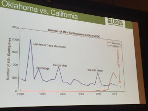
A one-year seismic hazard model for the central and eastern U.S., published in March, does show a “precipitous drop in the earthquake rate, but it is still far higher than what we had been seeing as a historical average for this part of the world,” said Rubinstein.
Rubinstein also showed a dramatic video produced by seismicsoundlab, demonstrating the explosive proliferation of Oklahoma earthquakes since 2004, which drew gasps and applause from the town hall audience.
Stuart Ellsworth discussed the Colorado permitting process for oil and gas wells, and spoke about the rapid response to the 2014 magnitude 3.2 Greeley, Colorado earthquake, which took place in an area of extensive wastewater disposal wells. Ellsworth said state agencies and the oil and gas industry followed several steps to reduce induced seismicity in the region, including filling the bottom of one high-rate disposal well with concrete (to minimize its connection with basement rock) and carefully controlling water injection rates when disposal resumed.
The audience asked the expert panel, which included Julie Shemeta of MEQ Geo, about how often oil and gas wells are audited, what mitigation techniques work best to reduce earthquake rates from underground injection, and how state agencies are using the new one-year hazard maps produced by the USGS.