This electronic supplement contains an additional table (Table S1, main terrace surface and basal contact offset measurements), an additional figure (Fig. S1, an unrealistic faulting scenario, as a compendium to Fig. 11 in the main article), and a KML file with the fault-trace mapping spanning the Lower Rhine graben.
Table S1. Main terrace surface and basal contact offset measurements.
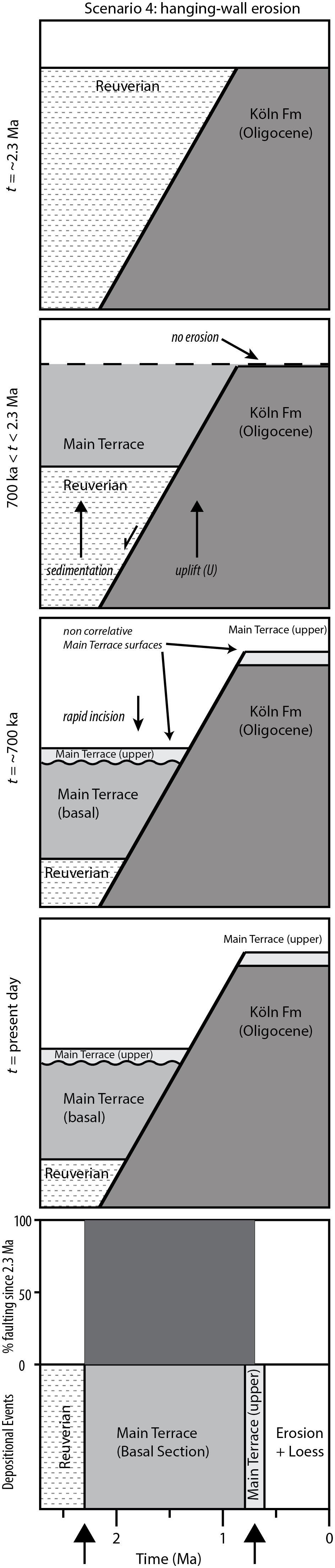
Figure S1. Unrealistic scenario 4, not considered in Figure 11 in the main article. In this scenario, all Quaternary faulting occurs in the interval from 2.29 to 700 ka. In this scenario, the main terrace surface offset is an apparent displacement, resulting from incision of the main terrace into the hanging wall. Importantly, the main terrace footwall and hanging-wall surfaces are not correlative. This scenario is inconsistent with a number of regional paleoseismological trenching studies that have documented surface faulting in the past 10–100 ka (Camelbeeck and Meghraoui, 1998; Vanneste et al., 1999, 2001; Camelbeeck et al., 2007; Kuebler, 2012; Grützner et al., 2016). Furthermore, this scenario is inconsistent with regional mapping and interpretation of the sedimentary conditions at ~700 ka, during which time significant stream aggradation and regional deposition is interpreted to have occurred (Boenigk and Frechen, 2006). We discard this scenario from further consideration.
Download: Fault Traces KML File [Google Earth keyhole markup language file; ~217 KB]. A KML file depicting the surface trace of faults in the Lower Rhine graben. Mapping was conducted using a light detection and ranging (lidar)-derived 1-m bare earth terrain model and guided by previous mapping efforts (Ahorner, 1962; Knapp et al., 1978; Zitzmann, 1984, 2002; Burghardt, 1987; Houtgast et al., 2002; Geologischer Dienst Nordrhein-Westfalen, 2003; Michon and Van Balen, 2005; Vanneste et al., 2013). Our mapping was conducted at a spatial resolution of ~1:15,000 and is not suitable for use at larger scales. The line work is accompanied by the following attributes: type (e.g., normal fault, lineament); confidence (solid, dash, query, concealed); source (e.g., lidar; Ahorner, 1962; Vanneste et al., 2013); dip direction (e.g., east, west); and length (in meters).
Ahorner, L. (1962). Untersuchungen zur quartären Bruchtektonik der Niederrheinischen Bucht, Eiszeitalt. Ggw. 13, 24–105 (in German).
Boenigk, W., and M. Frechen (2006). The Pliocene and Quaternary fluvial archives of the Rhine system, Quaternary Sci. Rev. 25, 550–574.
Burghardt, O. (1987). Geologische Karte Blatt C 5506 Bonn, Geologisches Landesamt Nordrhein-Westfalen, Krefeld, Germany (in German).
Camelbeeck, T., and M. Meghraoui (1998). Geological and geophysical evidence for large palaeo-earthquakes with surface faulting in the Roer graben (northwest Europe), Geophys. J. Int. 132, 347–362.
Camelbeeck, T., K. Vanneste, P. Alexandre, K. Verbeeck, T. Petermans, P. Rosset, M. Everaerts, R. Warnant, and M. Van Camp (2007). Relevance of active faulting and seismicity studies to assessments of long-term earthquake activity and maximum magnitude in intraplate northwest Europe, between the Lower Rhine embayment and the North Sea, Geol. Soc. Am. Spec. Pap. 425, 193–224.
Geologischer Dienst Nordrhein-Westfalen (2003). Geologische Karte von Nordrhein-Westfalen, Krefeld, Germany (in German).
Grützner, C., P. Fischer, and K. Reicherter (2016). Holocene surface ruptures of the Rurrand fault, Germany—Insights from palaeoseismology, remote sensing and shallow geophysics, Geophys. J. Int. 204, 1662–1677.
Houtgast, R. F., R. van Balen, L. M. Bouwer, G. B. M. Brand, and J. M. Brijker (2002). Late Quaternary activity of the Feldbiss fault zone, Roer Valley rift system, the Netherlands, based on displaced fluvial terrace fragments, Tectonophysics 352, 295–315.
Knapp, G., J. Gliese, and H. Hager (1978). Geologische Karte der nördlichen Eifel, Geologisches Landesamt Nordrhein-Westfalen, Krefeld, Germany (in German).
Kuebler, S. (2012). Active tectonics of the Lower Rhine graben (NW central Europe) based on new paleoseismological constraints and implications for coseismic rupture processes in unconsolidated gravels, Ph.D. Dissertation, Department for Earth and Environmental Sciences, Ludwig Maximimilians University, Munich, Germany, 168 pp.
Michon, L., and R. T. Van Balen (2005). Characterization and quantification of active faulting in the Roer valley rift system based on high precision digital elevation models, Quaternary Sci. Rev. 24, 455–472.
Salamon, M., and R. Koch (2004). Geologisches Modell der südlichen Rurscholle, Geologischer Dienst Nordrhein-Westfalen, Krefeld, Germany (in German).
Salamon, M., and S. Tobler (2013). Geologische Modellierung der Ville-Scholle: Fertiges Modell, Geologischer Dienst Nordrhein-Westfalen, Krefeld, Germany (in German).
Salamon, M., S. Sandmann, S. Becker, and S. Tobler (2015). Geologische Modellierung der Erftscholle: Gesamtgebiet - Fertiges Modell, Geologischer Dienst Nordrhein-Westfalen, Krefeld, Germany (in German).
Vanneste, K., T. Camelbeeck, and K. Verbeeck (2013). A model of composite seismic sources for the Lower Rhine graben, northwest Europe, Bull. Seismol. Soc. Am. 103, 984–1007.
Vanneste, K., M. Meghraoui, and T. Camelbeeck (1999). Late Quaternary earthquake-related soft-sediment deformation along the Belgian portion of the Feldbiss fault, Lower Rhine graben system, Tectonophysics 309, 57–79.
Vanneste, K., K. Verbeeck, T. Camelbeeck, E. Paulissen, M. Meghraoui, F. Renardy, D. Jongmans, and M. Frechen (2001). Surface-rupturing history of the Bree fault scarp, Roer Valley graben: Evidence for six events since the late Pleistocene, J. Seismol. 5, 329–359.
Zitzmann, A. (1984). Geologische Übersichtskarte Blatt CC 4702 Düsseldorf, Bundesanstalt für Geowissenschaften und Rohstoffe (BGR) (in German).
Zitzmann, A. (2002). Geologische Übersichtskarte Blatt CC 5502 Köln, Bundesanstalt für Geowissenschaften und Rohstoffe (BGR) (in German).
[ Back ]