|
|
Education: Eduquakes |
Guest Columnist:
John E. Ebel
Boston College
Weston Observatory
Boston College
381 Concord Road
Weston, MA 02493
ebel@bc.edu
Scientists are by nature a curious group of people (in all senses of that phrase!). Seismologists want to know everything they can about earthquakes, physicists about elementary particles, meteorologists about the weather, etc. Most scientists are curious not only about their own disciplines but also about many other scientific subjects as well. For example, I am a seismologist by training, but each fall I teach an introductory meteorology course to non-science majors at Boston College as part of the students' core science requirement.
It is a good thing that scientists are so widely curious, since it helps them in their work. This is because scientific phenomena are inherently interrelated. For example, the study of global climate change does not merely involve an analysis of the atmosphere. The Earth's oceans and its biosphere are intricately linked factors that play roles in controlling global climate. In fact, the movement of continents has likely played a crucial role in determining climatic conditions in the geologic past. Thus, scientists often look outside their own disciplines for ideas to help them understand phenomena they study.
For seismologists who routinely analyze seismograms, the presence of background noise is often a source of frustration, since such noise can partially or even totally obscure earthquake signals they wish to analyze. A study of seismic background noise can be an interesting subject on its own, however. There is a saying among scientists that is quite applicable to the subject of this EduQuakes column: "One person's noise is another person's signal."
If you've ever looked at the traces recorded by a sensitive seismograph, you will see that they are never flat. Rather, the traces indicate that there are always some vibrations that shake the ground. Some of these vibrations are man-made: vehicular traffic, people walking, operating machinery that shakes the ground. Other background vibrations are natural: the wind shaking the ground surface; waves hitting shores; the movement of water in rivers, lakes, and the oceans. Seismologists have a name for natural background vibrations. We call them microseisms. Microseisms are observed at all frequencies on seismograms, although there are some frequencies at which they are especially strong. Microseisms at frequencies above about 1 Hz are generally associated with local weather conditions, while below 1 Hz they reflect regional weather and ocean conditions. For seismic stations near the ocean, a particularly strong microseismic signal at a frequency of about .17 Hz (6-second period) apparently is caused by movements of water offshore and against the shoreline.
Since microseisms are caused primarily by meteorological conditions, an analysis of microseismic patterns on seismograms can reveal information about current weather conditions or how weather patterns are changing. High-pressure systems generally bring fair skies and light winds, and these are often reflected on seismograms by low levels of background microseismic noise. Low-pressure systems are typically accompanied by stronger winds, clouds, and precipitation. Microseisms on seismograms often are greater at times when low-pressure systems are near a seismic station.
During the fall, winter, and spring, those of us who live along the northeastern North American coast are often visited by storms that New Englanders call "nor'easters." These are low-pressure centers that travel from southwest to northeast along the coast, bringing cold, wind, rain, and higher-than-normal tides. Some can be quite strong, with wind gusts occasionally even exceeding hurricane force. During nor'easters, the microseisms on our seismograms in the New England region can be quite large. It is much more difficult to observe earthquake signals on our seismograms when such storms pass by.
If one studies the microseismic signals during passage of nor'easters at seismic stations in the Boston area, one finds a rather unexpected pattern. The strongest amplitudes for the microseisms do not occur when the low-pressure center is closest to the seismic stations. Rather, it occurs many hours later. In fact, the strongest microseisms can occur as much as half a day after the nor'easter has passed. Why is this?
The answer to this conundrum can be found by a simple, standard scientific investigation. One simply needs to study the passage of a number of nor'easters and then determine the positions of the low-pressure centers when the microseisms are greatest. One also needs to look at the geometry of the land and ocean for hundreds of miles around the seismic station.
The passage of a nor'easter over the Boston area on 20 and 21 March 2002 illustrates the answer to our question. This was a fairly strong nor'easter that brought a substantial amount of rain to Boston during the evening and night of 20-21 March. The strongest rainfall occurred late in the evening on 20 March, and it stopped during the early hours of 21 March. The sky cleared shortly afterward, and by the 6:00 a.m. EST sunrise on 21 March, the sky was perfectly clear and sunny.
A glance at the display of a home-made AS1 seismograph in Boston College's Devlin Hall (see http://www.eas.purdue.edu/~braile/news/seisschools.htm for information about the AS1 seismograph and recording system) on the morning of 21 March showed that the level of microseismic noise did not match the outdoor weather in Boston. During the morning of 21 March, the microseismic noise steadily increased, even though the weather had long since cleared. Figure 1, made at about 10:10 a.m. EST (1510 GMT) on 21 March, shows a 24-hour display of the ground motions recorded by the seismograph. The rain stopped in Boston between midnight and 3:00 a.m. on 21 March (0500 to 0800 GMT), but the microseisms were much smaller than they were later in the day. Curiously, as the weather was improving outside, the amplitude of the microseisms in the ground was increasing.
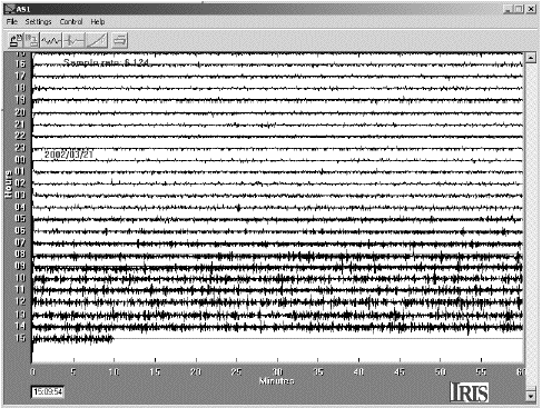
Figure 1. Screen image of the Boston College Devlin Hall educational seismograph display for a 24-hour period on 20-21 March 2002. The number at the left side of each line is the hour in GMT. To convert to EST, subtract 5 hours from GMT.
At first glance this might seem strange. But a plot of the center of low pressure from 20 March at 7:00 a.m. EST (1200 GMT) to 21 March at 7:00 a.m. EST (1200 GMT), shown in Figure 2, gives a clue to help explain this behavior. Notice the path of the storm from the southwest to the northeast across southern New England and into the Gulf of Maine. It was not until the low-pressure center passed north of Cape Cod and into the Gulf of Maine that the microseisms became strong on the Boston College seismograph. The strongest microseisms occurred at a time when the center of the storm was well out in the Atlantic Ocean and was near Nova Scotia. The low-pressure center was strengthening in intensity in the Gulf of Maine during the day of 21 March, increasing the movements of the surface waters of the ocean there. This probably helped increase the strength of the microseisms at Boston College throughout the day.
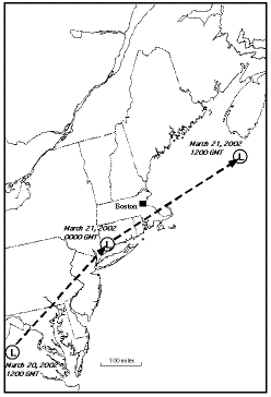
Figure 2. Approximate path of the low-pressure center for the nor'easter of 20-21 March 2002. The approximate positions of the low-pressure center on 20 March at 1200 GMT (7:00 a.m. EST), 21 March at 0000 GMT (7:00 p.m. EST), and 21 March at 1200 GMT (7:00 a.m. EST) are shown.
It turns out the weather and microseismic trends seen in Boston on 20-21 March are typical. Microseisms in the Boston area are generally weak for storms that stay south of Cape Cod and generally stronger for those low-pressure centers that traverse into the Gulf of Maine. In fact, the microseisms start noticeably increasing only after the low-pressure center moves out into the Gulf of Maine. Thus, it appears that the strong microseisms at Boston are generated primarily by water movements in the Gulf of Maine and the North Atlantic waters east of there. Also, nor'easters often strengthen when they pass into the Gulf of Maine. In general, the lower the pressure in the storm, the greater the microseisms. Therefore, there appear to be both oceanographic and meteorological reasons that strong microseisms occur when they do in the Boston area.
This example demonstrates that studying microseisms can help determine the movements and strengths of weather systems. While the example I have discussed here pertains to the situation in New England, people in other parts of the world can carry out similar investigations. The relationship of the positions and strengths of weather systems with microseismic levels on seismographs can be investigated by students anywhere. Of course, one needs to pay attention to the possible sources of the microseismic noise. In the Boston area, it appears that the strongest microseisms are caused by ocean movements in the Gulf and Maine and the North Atlantic to the east. In other parts of North America, the sources of microseismic noise will be different. The locations of weather systems relative to oceans, large lakes, mountains, and flatlands all may play a role in controlling the generation of microseisms.
If a school has a seismograph in operation, a study of the variations of microseisms with time and with the positions of weather systems can be an interesting project. It would help students to learn the tie between natural ground vibrations and meteorology. It would encourage students to pay attention to the movement of weather systems across their region. It could even make for an interesting and educational science fair or class project.
SRL encourages guest columnists to contribute to "EduQuakes." Please contact Larry Ruff with your ideas. His e-mail address is eduquakes@seismosoc.org.
Posted: 10 December 2002