|
|
Publications: SRL: Opinion |

March/April 2008
Challenges Ahead for the Global Seismographic Network
Twenty-five years ago, a new global digital seismic network was identified by the National Academies’ Committee on Science, Engineering, and Public Policy as one of five research areas in which significant dividends could be expected as a result of incremental federal investment. That recommendation, through coordinated planning and support by scientists, mission agencies, and international partners, spawned the development of the Global Seismographic Network (GSN). The GSN is a joint program of the National Science Foundation (NSF) and the U.S. Geological Survey (USGS). The NSF program is implemented by the Incorporated Research Institutions for Seismology (IRIS) and the University of California at San Diego (UCSD); the USGS program is implemented by the Albuquerque Seismological Laboratory.
The GSN has now far exceeded initial plans and expectations, both in terms of its operational scope and performance and the scientific applications of the data it produces. Originally envisioned as a 100-station network to gather data mainly for research applications, the network has evolved into a real-time Earth-observing system also supporting earthquake alerts, tsunami warning, nuclear treaty verification, and other uses.
Several recent publications have documented the GSN’s remarkable successes. Butler et al. (2004) emphasized that the GSN had exceeded its original technical design goal of 128 globally distributed stations—last year the core network plus affiliates reached 150 stations, strategically scattered across continents and islands from the Arctic to the South Pole. One in four of these stations has evolved into a cooperative “geophysical observatory,” which may include a range of sensor types (gravimeters, GPS receivers, magnetometers, microbarographs, etc.) in addition to the broadband and very-broadband seismometers that are capable of faithfully recording both the largest earthquake sources and the smallest whole-Earth oscillations. By the end of 2007, more than 95% of GSN stations had real-time telemetry, and the network operated at nearly 90% data recovery.
As a research tool, the GSN’s global coverage and highfidelity, broad-frequency sensors target mapping of the Earth’s velocity structure at tens to hundreds of kilometers with unprecedented resolution. Details of the Earth’s anisotropic velocity perturbations and attenuation from inner core to crust have been uncovered using GSN data. Discoveries abound that were unanticipated when the system was designed, including inner core differential rotation, detection of glacial earthquakes, ocean storm monitoring, and historical changes in sea state possibly related to climate change.
Following the M 9 Sumatra-Andaman earthquake in 2004, Park et al. (2005) documented the network’s strong contributions to the scientific understanding of that unique event and its many triggered phenomena. In contrast to the GSN’s antecedent, the World-Wide Standardized Seismographic Network (WWSSN), whose stations were driven off-scale by the similar-sized 1964 Alaska earthquake, the GSN provided both on-scale recordings of the 2004 earthquake and new records of the Earth’s smallest-recorded free oscillations. Some details of these oscillations (for example, the five singlets of the 0S2 multiplet) had never before been observed in a single record. Park et al. emphasized that “technological advances have enabled real-time data acquisition and rapid response capabilities that were not fully envisioned when the Incorporated Research Institutions for Seismology, the National Science Foundation and the USGS designed the GSN in 1984” (Park et al. 2005).
GSN real-time data are fully integrated into the operations of the USGS National Earthquake Information Center (NEIC) and the two National Oceanic and Atmospheric Administration (NOAA) tsunami warning centers. These centers depend on GSN data to meet their performance objectives. The warning centers now typically generate an initial tsunami information message in less than 10 minutes for distant earthquakes. This compares with typical warning times of about 50 minutes a decade ago and 20 minutes at the time of the 2004 Sumatra-Andaman earthquake. This performance would not be achievable without GSN real-time data.
Similarly, the USGS has set, and NEIC now typically surpasses, a minimum performance target of 20 minutes for a reviewed earthquake solution. The broadband response of the GSN is essential for higher-order earthquake source characterizations now routinely conducted at the NEIC, including centroid moment tensors and finite-fault slip-distribution estimates. The global real-time data also support improved emergency response for damaging earthquake disasters worldwide through the USGS product Prompt Assessment of Global Earthquakes for Response (PAGER; see http://www.earthquake.usgs.gov/pager). This system currently provides rapid estimates of shaking exposure to population, and its developers anticipate that PAGER will provide automated loss estimates, both human and economic, before the end of this decade. All these products depend on accurate models of the earthquake source, the development of which depends upon GSN data.
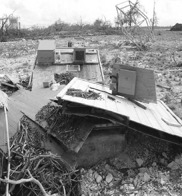
▲ Figure 1. Remains of the GSN station on Wake Island, destroyed by a class 5 typhoon in September, 2006. Photo courtesy of Chod Hill, U.S. Air Force (click to see a larger version).
The GSN has engendered remarkably effective global cooperation, through the International Federation of Digital Seismograph Networks, in the development of standards and protocols for global seismographic observation, instrumentation, and data sharing. Among the wide range of global Earthobserving systems that are currently in place internationally, it is generally recognized that seismology sets a high standard for international cooperation and coordination, in part because of the sustained efforts of GSN managers. Through such coordination, GSN data contribute to nuclear treaty verification through the auxiliary network of the International Monitoring System, and to nuclear-monitoring research in areas such as source identification, explosion discrimination, and crustal/ mantle modeling.
In view of these successes, one could assume that with continuing technical advancements, effective coordination, due operational diligence, and perhaps a bit of luck, the applications and use of GSN data will continue to grow into the future, supporting hazard warning, nuclear monitoring, and research. Such an optimistic assumption, however, must be tempered by several operational realities and, perhaps, historical experience. Known technical, operational, and resource challenges face the network operators, USGS and UCSD, as they strive to maintain the network into the next decade at its current level of performance.
Technical challenges have been documented recently in these pages. They include stemming the recently demonstrated degradations in the performance of the GSN’s two principal seismometers, the KS-54000 and STS-1. Failures of the KS-54000, which averaged one per year in the 1990s, have increased to three per year since 2000 within the USGS subnetwork. Analysis of gain errors within the GSN (Ekstrom et al. 2006) indicates a time-dependent deterioration of STS-1 performance over the past 15 years. The situation is further complicated by the fact that the STS-1 is no longer manufactured, and there is as yet no replacement sensor that fully matches its capabilities. Overall, sensor calibration of the GSN may be very good, but more than 25% of the stations do not meet the GSN’s stringent operational standards (Davis et al. 2005). The situation is similar for data-loggers, more than half of which are more than 15 years old. Recognizing an increasing failure rate— and seeing the opportunity to improve performance—network managers are planning for the replacement of all station dataloggers. However, at current budget levels, this system maintenance task will not be able to match estimated failure rates.
Operational challenges include the difficulties of maintaining the most remote sites “on the cheap.” For example, in September 2006, a typhoon destroyed the Wake Island GSN site (figure 1). That site, which is unmanned, remained down for 14 months until it was restored in November 2007, despite Wake’s important location in support of Pacific tsunami warning. The station at Magadan, Russia, was destroyed by fire in 2007. Replacement costs for these two stations are a significant fraction of the annual operating budget for the network.
Coordination challenges include the association, by certain countries, of real-time seismic data with national security, resulting in restrictions on its availability for hazard warning. Despite the easily demonstrated regional degradation in performance of global warning systems when a country’s data are withheld, and the agreements of these same countries to data-sharing principles (for example through the multinational Group on Earth Observations, GEO), it appears that security concerns still hold sway in several instances. These decisions place limits on future applications of GSN data to risk and loss reduction and may affect the timeliness of disaster response.
Concern for the future GSN is based in part on experience— for example, faced with similar challenges, the WWSSN began a slow decline soon after it was completed in 1967 (figure 2). Without adequate operational funding, WWSSN performance slowly degraded such that the number of working stations was reduced by nearly 30% over 20 years and further degraded to about half the network over 30 years. Network completion is a beginning, not an end, and there is a need for continual rejuvenation of such a network, both to improve operational capabilities and to open new avenues for scientific exploration.
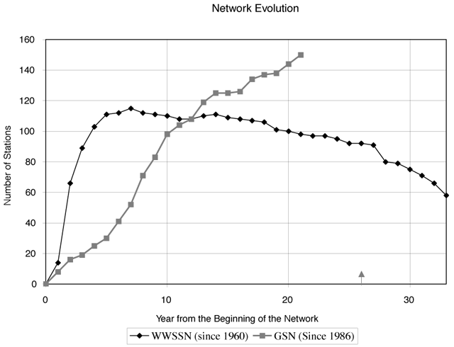
▲ Figure 2. Annual count of the number of stations in the WWSSN and the GSN since the first station installations in each network. Graphic courtesy of Rhett Butler, IRIS.
Projected funding of the GSN program by NSF and USGS is flat, and tight budgets can be expected to continue in the future across the federal government. With rising costs, network operators can expect an erosion of their ability to cope with station failures, much less expect the resources necessary to refresh the network’s instrumentation so that it is maintained at high technical standards. While program managers have in recent years tried to maintain small reserves for innovation and development, these will disappear quite soon in the face of increased fixed costs. Hopes to fill coverage gaps in broad ocean areas will likely remain just hopes, although GSN managers persistently seek opportunities to leverage other ocean-sensor deployments for the benefit of global seismology.
While it is natural for scientists and agencies to take the current high-flying performance of the GSN as a sign of what can be expected in the future, it is important that the network’s many stakeholders be aware of these challenges and past experience with global network operations and contribute appropriately to addressing them. The GSN emerged through a coordinated alignment of the goals and aspirations of national and international scientists and mission agencies. A healthy future lies in the sustained involvement of all partners in supporting a global facility upon which we have come to rely.. ![]()
REFERENCES
Butler, R., T. Lay, K. Creager, P. Earl, K. Fischer, J. Gaherty, and G. Laske et al. (2004). The Global Seismographic Network Surpasses Its Design Goal. EOS Transactions, American Geophysical Union 85 (23) doi:10.1029/2004EO230001.
Davis, P., M. Ishii, and G. Masters (2005). An Assessment of the Accuracy of GSN Sensor Response Information. Seismological Research Letters 76 (6), 678–683.
Ekstrom, G., C.A. Dalton, and M. Nettles (2005). Observations of Timedependent Errors in Long-period Instrument Gain at Global seismic Stations, Seismological Research Letters 77 (1), 12–22.
Park, J., R. Butler, K. Anderson, J. Berger, H. Benz, P Davis, and C. R. Hutt et al. (2005). Performance Review of the Global Seismographic Network for the Sumatra-Andaman Megathrust Earthquake, Seismological Research Letters 76 (3), 331–343.
To send a letter to the editor regarding this opinion or to write your own
opinion, you may contact the SRL editor by sending e-mail to <lastiz [at] ucsd.edu>.
[Back]
Posted: 13 March 2008