This electronic supplement contains horizontal and vertical slip distribution plots with both LiDAR-based and field-based slip measurements; data tables of LiDAR-based horizontal and vertical displacement measurements; Google Earth index files of shaded relief maps with two different illumination angles and the locations where horizontal and vertical displacement measurements were made; LiDAR data files; and access information to view screen captures of the displacement measurements.
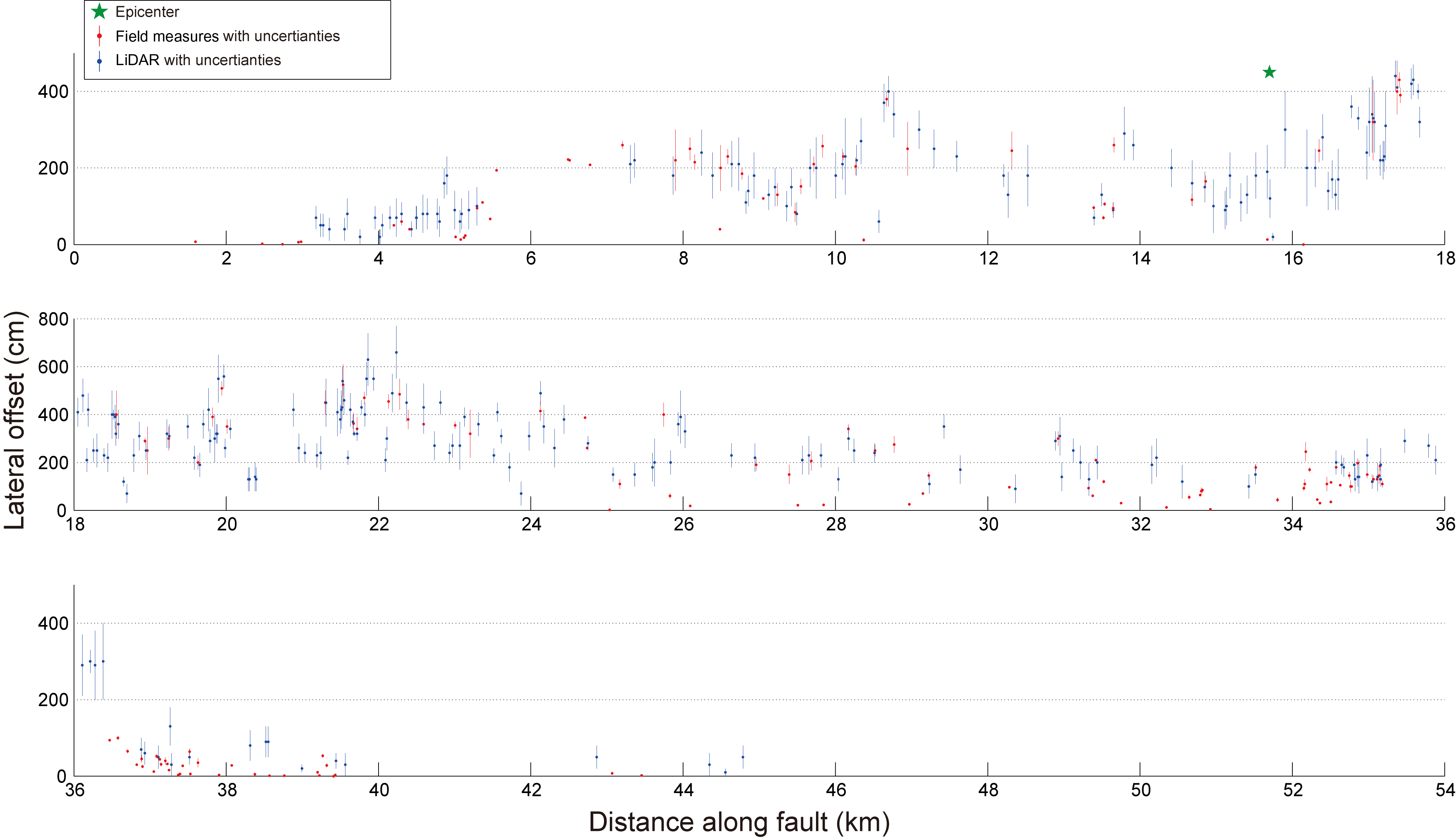
Figure S1. Slip distribution: LiDAR-based and field-based (Treiman et al., 2002) horizontal offset measurements are plotted along the strike of the surface rupture of the Hector Mine earthquake.
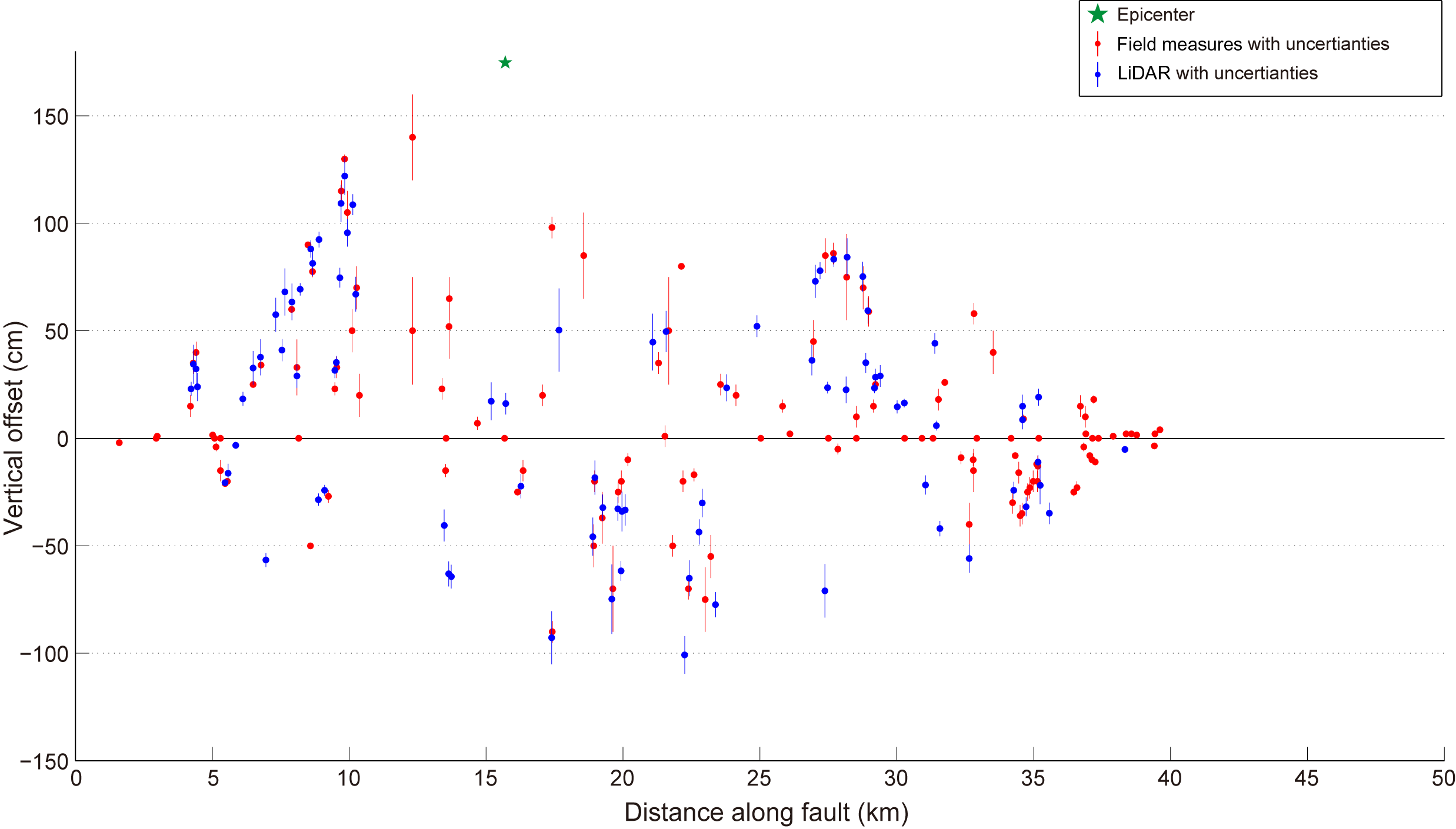
Figure S2. Slip distribution: LiDAR-based and field-based (Treiman et al., 2002) vertical offset measurements are plotted along the strike of the surface rupture of the Hector Mine earthquake.
Table S1. Horizontal offset measurements from LiDAR data. This data table includes location, offset measurement, measurement error estimation, and quality of measurement for each measurement, as well as the name of the fault and the lithology on which the measurement is made. The reference frame is the World Geodetic System 1984 (WGS84) UTM zone 11N.
Table S2. Vertical offset measurements from LiDAR data. This data table includes location, offset measurement, measurement error estimation, and quality of measurement for each measurement, as well as the name of the fault and the lithology on which the measurement is made. The reference frame is WGS84 UTM zone 11N.
Download: Google Earth Index S1 [compressed keyhole markup language file (KMZ); ~53.1 MB]. Hector Mine Hillshade_45 contains the hillshade map of the Hector Mine surface rupture derived from LiDAR data illuminated from 45 degrees.
Download: Google Earth Index S2 [compressed keyhole markup language file (KMZ); ~54.6 MB]. Hector Mine Hillshade_135 contains the hillshade map of the Hector Mine surface rupture derived from LiDAR data illuminated from 135 degrees.
Download: Google Earth Index S3 [compressed keyhole markup language file (KMZ); 17 KB]. Hector Mine horizontal displacement locations, where LiDAR-based horizontal offset measurements along the Hector Mine surface rupture were made.
Download: Google Earth Index S4 [compressed keyhole markup language file (KMZ); 8 KB]. Hector Mine vertical displacement locations, where LiDAR-based vertical offset measurements along the Hector Mine surface rupture were made.
Download: All GE Index Files [ZIP archive of Google Earth index files S1–S4; ~102.7 MB].
The LAS and LAZ files are in standard LiDAR point cloud file format and can be viewed in Quick Terrain Modeler; a free trial version can be downloaded from http://appliedimagery.com/download (last accessed January 2015). The DAT file can be viewed in any text editor, such as Ultraedit (a free trial version can be downloaded from http://www.ultraedit.com/downloads/ultraedit_download.html; last accessed January 2015).
Download/View: LiDAR S1 [HectorMineLiDAR_pointcloud.dat; point cloud data; 992.8 MB]. LiDAR point cloud data in ASCII (x, y, z) format. Data has been projected to UTM11N coordinates using the World Geodetic System 1984 (WGS84) datum.
Download: LiDAR S2 [HectorMineLiDAR_pointcloud.las; LiDAR data exchange file point cloud data; 316.6 MB]. LiDAR point cloud data in LAS format. Data has been projected to UTM11N coordinates using the WGS84 datum.
Download: LiDAR S3 [HectorMineLiDAR_pointclouds.laz; compressed LiDAR data exchange file; 1.55 GB]. LiDAR point cloud data in zipped LAZ format. Data has been projected to UTM11N coordinates using the WGS84 datum.
Screen captures of the individual horizontal and vertical displacement measurements are available in two PDF documents on the Caltech FTP server. (Both files were last accessed January 2015.)
Treiman, J. A., K. J. Kendrick, W. A. Bryant, T. K. Rockwell, and S. F. McGill (2002). Primary surface rupture associated with the Mw 7.1 16 October 1999 Hector Mine earthquake, San Bernardino County, California, Bull. Seismol. Soc. Am. 92, 1171–1191.
[ Back ]