Electronic Supplement to
Surface Rupture of the Kunlunshan Earthquake (Ms 8.1), Northern Tibetan Plateau, China
by Xiwei Xu, Wenbin Chen, Wentao Ma, Guihua Yu, and Guihua Chen
Institute of Geology, China Seismological Bureau
Photo Gallery of Surface Rupture Evidence from the
Kunlunshan Earthquake of 14 November 2001
Page 1 * (Photos 1-7)
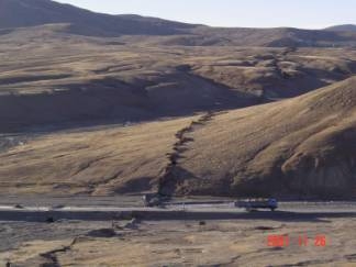
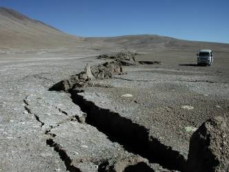
| Photo 1. Surface rupture zone of Kunlunshan earthquake crossing Gelmod-Lhasa Road in N80°W direction at the 2894 km road marker, which consists of pure shear fractures, shear fractures, transtensional fractures, tension gashes, and mole tracks in en echelon pattern with a width of 10 m to 32 m (photo toward the west). |
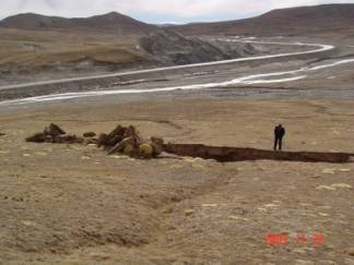
| Photo 2. A N80°W-trending pure shear fracture offset a shallow gully 3.9 m in a left-lateral sense and a mole track occurred at its eastern end just a few tens of meters west of the 2894 km road marker from Gelmod to Lhasa (photo toward the south). |
|
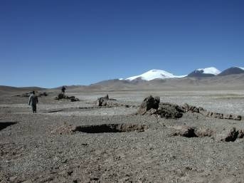
| Photo 3. N72-75ºE-trending shear fractures in left-lateral right-stepping and mole tracks in stepovers about 1 m high on the youngest terrace surface at outlet of Baladacaiqu Stream (photo toward the northwest). |
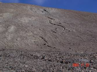
| Photo 4. Left-lateral right-stepping N65ºE-trending transtensional fractures and low mole tracks in stepovers about a few decades of centimeters high at the eastern end of the northern branch of a restraining stepover 47 km east of Kunlunshan Pass (photo toward the northeast). |
|
|
Photo 5. N45ºE-trending tension gash at the southwestern end of a N80ºE-trending pure shear fracture on the youngest terrace surface at outlet of Baladacaiqu Stream (photo toward the east).
|
| Photo 6. Two secondary surface rupture zones, consisting of shear fractures, transtensional fractures, tension gashes, and mole tracks, are arranged left-stepping to form a second-order pull-apart structure where tension gashes are well developed (photo toward the east). |
|
|
Photo 7. Slicksides with a dip angle of 28° toward the east on the southern fault plane, showing left-lateral slip with a little reverse (vertical) component, just a few tens of meters west of the 2,894 km road marker from Lhasha to Gelmod (photo toward the south). |
[Photos 1-7] [Photos 8-14] [Photos 15-21]
[ Back ]