15 April 2026— A new look at the Juan de Fuca tectonic plate beneath the coast of northern Oregon suggests this subducting slab is shallower than previously thought, with impacts on potential peak ground shaking during a Cascadia megathrust earthquake.
The Juan de Fuca plate dives beneath the North American plate to form the Pacific Northwest’s Cascadia subduction zone, which has produced devastating magnitude 9 earthquakes historically.
“We estimate that the slab interface is about 20 kilometers [deep] near the coastline, which is about 5 kilometers shallower than previous estimates,” said Erin Wirth, a seismologist with the U.S. Geological Survey who presented the results at the 2026 SSA Annual Meeting.
“This could increase estimated peak ground acceleration—in other words, shaking intensity—from Cascadia megathrust earthquakes by approximately 9 to 17%,” along the coast of northern Oregon, she added.
The research team also identified a deep sedimentary basin beneath Tillamook, Oregon, providing the first direct seismological constraints on its geometry and depth. “Sedimentary basins can amplify ground shaking during an earthquake and have been well-studied in other parts of the Pacific Northwest such as the Seattle Basin,” Wirth explained. “Characterizing the presence of a sedimentary layer, as well as its likely thickness, helps scientists to more accurately estimate ground shaking from future earthquakes.”
The study by Wirth and colleagues helps to fill in an important geographical blank in scientists’ understanding of the Cascadia subduction zone. Northern Oregon is relatively seismically quiet compared to its neighbors in western Washington and northern California, so there are fewer earthquakes to mine for data to learn what the subducting slab looks like at depth and how seismic waves propagate through the ground.
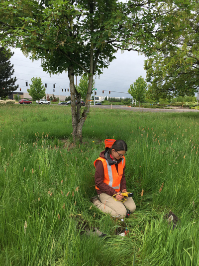
To learn more about the structure of the subduction zone beneath the coastline near northern Oregon, Wirth and her colleagues deployed 192 temporary nodal seismometers in the summers of 2021 and 2022 in an array from Tillamook to Portland. The researchers combined their data with a complementary study of seismic recordings made offshore from Vancouver Island to northern California in 2021 that that also noted a shallower slab depth offshore.

Together, the data provide a new detailed map of the structure of the subduction zone that could help researchers better estimate seismic hazard for northern Oregon.
Earthquakes that rupture closer to the surface are likely to cause more intense ground shaking compared to deeper earthquakes, where the seismic energy released is likely to weaken and spread out before it reaches the surface. That’s one way that a shallower Juan de Fuca slab beneath northern Oregon could lead to more intense peak ground shaking in populated areas.
And in a sedimentary basin like the one discovered beneath Tillamook, sediments can act like a “bowl of jello.” Seismic waves strongly shake the weak material and get trapped against the basin edges, potentially allowing shaking to last longer as a result. These amplified seismic waves can be especially damaging to tall buildings and large structures.
Wirth said the researchers plan to use the dataset from the nodal seismometer deployment to further examine the Tualatin Basin near Portland.