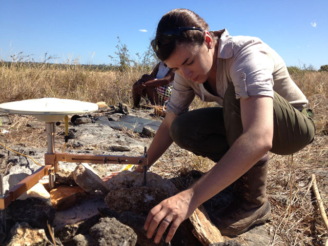
15 October 2020–The shape of the Earth may seem stable, but Virginia Tech geophysicist D. Sarah Stamps knows differently. She and her colleagues track its shifting shape millimeter by millimeter, quantifying the horizontal and vertical motions of the tectonic plates to get at the physics behind the plate motions.
The tools of geodesy– the study of how the Earth’s shape changes—include GNSS (Global Navigation Satellite System) data, numerical modeling and programming. While not a seismologist, Stamps’ work has applications for seismic hazard.
“When you understand how and why the Earth’s shape changes, figuring out some of the processes that drive earthquakes and volcanic activity becomes possible,” she explains. “By measuring where more surface deformation is occurring compared to a region where it’s rigid and there is very little relevant surface motion you can get some idea about where you might expect to have earthquakes.”
Stamps and her colleagues work at field sites around the world, drawn to places “where we can design experiments to look at specific processes,” she says. Continental rifting is one of her main interests, so she has a major field site in the “natural laboratory” of the Natron Rift of the East African Rift System in Tanzania. “I just find it fascinating that we can go from solid, stable continents to it completely breaking up and creating a new ocean,” she says.
Stamps recently received funding to embark on a “dream project” related to rifting in Africa. Ever since she was a postdoc, she has wanted to build an observatory around the Natron Rift’s Ol Doinyo Lengai volcano. After installing 6 GNSS stations around the volcano, she received support through the NSF CAREER program to expand the project, “which involves volcanic hazards assessment as well as understanding the early phases of continental rifting,” she explains.
Her Tanzanian collaborator on the project is Dr. Elifuraha Saria at Ardhi University. Through a separate NSF funded project, Stamps will also work with Dr. Fred Tugume at the Ministry of Mining and Energy Development and Dr. Kevin Aanyu at Makerere University in Uganda to study a more unusual, magma-poor type of continental rifting in a place with little volcanism known as the northern Western Branch of the East African Rift System. Stamps’ international collaborations include work with researchers in Kenya, Madagascar and China as well. Her lab at Virginia Tech will soon include graduate students from Tanzania and Uganda who will be supported by the two new project grants. Stamps has also taught short courses in using GNSS and other geodesy tools through programs such as AfricaArray that promote and strengthen a network of geoscience researchers in Africa.
The technology and technical skills needed for her own research have changed over the years, since Stamps was an undergraduate at the University of Memphis advised by Professor Robert Smalley. For instance, the global satellite systems operations under the banner of GNSS have expanded geodesy beyond GPS (Global Positioning Satellite) satellites operated by the U.S. The capabilities and access to supercomputing facilities has expanded as well, she says.
As co-chair of the Science and Engagement Team of EarthCube, an NSF program aimed at modernizing the geosciences with new technology, Stamps has been working on ways to make data sets more accessible and easier to use. She is the principal investigator on EarthCube’s BALTO (Brokered Alignment of Long-Tail Observations) project, which is exploring software and other technical solutions to connecting global users to “long tail” data sets that have been collected by individual scientists in new and unusual ways, as well as large data sets from NASA, NOAA and the USGS. She is a principal investigator on EarthCube’s CHORDS project, which facilitates access to real-time geoscience data streamed from field sites, such as her own siteat Ol Doinyo Lengai .
Stamps also has research and outreach interests closer to home. At another of her lab’s field sites, on Virginia’s Chesapeake Bay, she and her students study the “geological processes that influence vertical land motions along coasts and how they impact sea level rise and its hazards for coastal population,” she says.
“And our group is really committed to increasing diversity, equity, and inclusion in the geosciences,” Stamps adds. Through the Chesapeake field site and others, her lab provides research opportunities to underrepresented minorities. The lab also participates in a spring break program aimed at teaching coding skills and data collection skills that can better prepare underrepresented minorities for graduate school in the sciences.
Stamps’ own introduction to the geosciences came in high school, when she participated in a program at the former University of Missouri, Rolla (now Missouri University of Science and Technology) about possible career paths in the sciences. “When they described geophysics, they showed us images of the Earth’s interior and particular faults. I had no idea you could use technology to peer into the Earth,” she recalled. “I became absolutely fascinated by geophysics.”
SSA At Work is a monthly column that follows the careers of SSA members. For the full list of issues, head to our At Work page.