23 May 2023–Three studies now published in the open-access journal The Seismic Record offer an initial look at the February 6, 2023 earthquakes in south-central Türkiye and northwestern Syria, including how, where, and how fast the earthquakes ruptured and how they combined as a “devastating doublet” to produce damaging ground shaking.
The two earthquakes, a magnitude 7.8 followed approximately nine hours later by a magnitude 7.6, took place at the tectonically active and complex junction between the Anatolian, Arabian, and African plates along the East Anatolian Fault (EAF) strands. Most recent large earthquakes have taken place on the North Anatolian Fault in Türkiye, while only three moderately sized earthquakes—the largest at magnitude 6.8—have occurred on the EAF within the past 50 years.
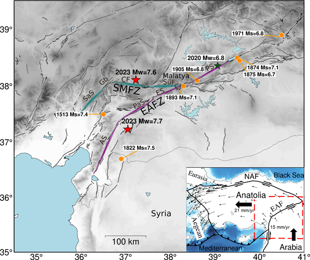
First Analyses of Rupture and Aftershocks
The epicenter of the first, magnitude 7.8 mainshock is located about 15 kilometers east of the EAF. The epicenter of the second, magnitude 7.6 earthquake is on the Sürgü-Misis Fault Zone (SMFZ) about 90 kilometers to the north of the first earthquake.
The first earthquake ruptured the EAF bilaterally (in two different directions away from the epicenter), over a fault length of about 350 kilometers (including aftershocks) in 80 seconds, creating surface fault offsets of more than six meters, according to an analysis by P. Martin Mai of King Abdullah University of Science and Technology and colleagues. The second earthquake also ruptured bilaterally over roughly 170 kilometers (including aftershocks) over 35 seconds, with more than seven meters of surface fault offset, they note.
An analysis led by Gesa M. Petersen of Helmholtz Centre Potsdam GFZ German Research Centre for Geosciences suggests the first mainshock ruptured up to 560 kilometers in multiple phases over a total of 117 seconds, while the second earthquake ruptured about 115 kilometers over 32 seconds, with aftershocks being distributed along roughly 160 kilometers of the SMFZ. In this study, the researchers traced the rupture direction of each earthquake, showing that the first involved multiple directional phases and segmented rupture. Their analysis of mainshocks and aftershocks provided new details about how the EAF and SMFZ ruptured and illuminated a previously unmapped fault segment close to the Turkish city of Malatya.
In their TSR paper, Dara E. Goldberg of the U.S. Geological Survey and colleagues relied on optical and radar imagery, available in the first few days after the sequence began, to clarify the rupture trace. As new imagery became available, the U.S. Geological Survey’s National Earthquake Information Center (NEIC) updated source characterization and impact analyses to reflect new understanding of the rupture extent. In total, the group mapped more than 340 kilometers of rupture associated with the mainshock and roughly 175 kilometers of rupture associated with the subsequent event.
Mai and colleagues said that the occurrence of two large earthquakes taking place so close in time as a “doublet” is uncommon, but that the first mainshock may have created stress changes in the area of the second earthquake’s epicenter that caused failure at the SMFZ.
Goldberg and colleagues argue that statistically there is about a 7% chance of an earthquake triggering a doublet, indicating this behavior is not anomalous.
Aftershocks from the two earthquakes demonstrated a variety of mechanisms, including strike-slip, normal and thrust faulting, said Petersen and colleagues. Strike-slip mechanisms similar to the two mainshocks are observed on the northeastern EAF segments and along most of the SMFZ, while the team observed normal faulting aftershocks in the southwestern EAFZ segments, as well as clustered at the western termination of the SMFZ.
Combined with the way the rupture process appeared to jump between different fault segments, Petersen and colleagues suggest that the evolution of the Türkiye earthquake rupture processes is similar in the degree of complexity to the 2022 Denali, Alaska of 2016 Kaikoura, New Zealand earthquakes.
Rapid Response
The USGS NEIC rapidly characterizes earthquakes around the world, and its products like ShakeMap and PAGER (Prompt Assessment of Global Earthquakes for Response) are often sought by researchers in the immediate aftermath of a large earthquake, said Goldberg and colleagues. In the case of the Türkiye earthquakes, traffic to the USGS public earthquake event web pages had 1,035,364 visits in the 24 hours after the start of the sequence.
In keeping with their role as a first-order indicator of how government agencies might respond in an earthquake’s aftermath, NEIC released its initial ShakeMap for the magnitude 7.8 event 15.7 minutes after the start of the sequence, and its PAGER assessment 21.2 minutes after the earthquake’s origin time, with similar timing for the subsequent event, according to Goldberg and colleagues.
Ground Motion Details
Mai and colleagues write that strong motion recordings made during the first mainshock found that peak ground acceleration (the maximum ground acceleration that occurs during earthquake shaking at a particular location) reached up to 2g locally. This measure corresponds to extreme perceived shaking and very heavy damage.
Rupture in both earthquakes stopped abruptly, which could have contributed to radiation of strong seismic shaking, these researchers note. Ground motions from the second mainshock would have then hit buildings weakened by the first mainshock, possibly increasing damage and destruction as a result.
PAGER, the U.S. Geological Survey’s loss estimation product, likely underestimated the impact of the sequence as a whole, because it does not consider repeated shaking due to aftershocks, write Goldberg and colleagues. A composite ShakeMap that includes the maximum shaking intensity at each location for the entire earthquake sequence may be more appropriate to estimate losses for this damaging earthquake sequence, they conclude.
If a composite ShakeMap had been used as input to PAGER, PAGER’s final assessment of the sequence would have included 30,000 total deaths and $51 billion in economic losses, said Goldberg and colleagues.