Seismological Society of America > News

5 September 2025—Resilience is a term often discussed in the face of a natural disaster such as a major earthquake, but the attributes of resilience and how they interact are rarely analyzed, researchers say in a new study published in the Bulletin of the Seismological Society of America. To learn … Continue Reading »

How can SSA best serve your professional needs and continue making advances in the field of seismology? Keep that question in mind as you read the candidate statements below for our 2026 Board of Directors Election. Then be sure to cast your vote! As the governing body for SSA, the Board … Continue Reading »
19 August 2025—What lies beneath Fickle Hill in northern California? Maybe the answer to an earthquake mystery that has puzzled seismologists for decades. The origin of the 1954 magnitude 6.5 earthquake that rattled residents around Humboldt Bay has been unclear, but a new study now suggests a surprising source: the … Continue Reading »

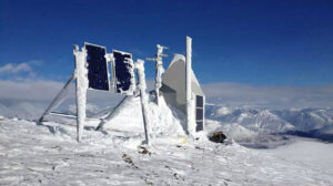
18 August 2025—There’s a lot of things that Rob Anthony likes about New Mexico. But as a geophysicist interested in noise, there’s one aspect that stands out: the relative seismic quietness. “We’re one of the quietest spots in the United States,” Anthony says of his workplace at the Albuquerque Seismological … Continue Reading »
15 August 2025—The Seismological Society of America announces its search for the next Editor-in-Chief (EIC) of the Bulletin of the Seismological Society of America (BSSA), its flagship, peer-reviewed international journal. Nominations for the position, including self-nominations, will be accepted through October 2025. The EIC leadership transition is scheduled to take … Continue Reading »
5 August 2025—For a wide variety of earthquake scenarios in Alaska, an earthquake early warning (EEW) system could provide at least 10 seconds of warning time for hazardous shaking, according to a new report. Increasing the density and improving the spacing of seismic stations around the state could add 5 … Continue Reading »