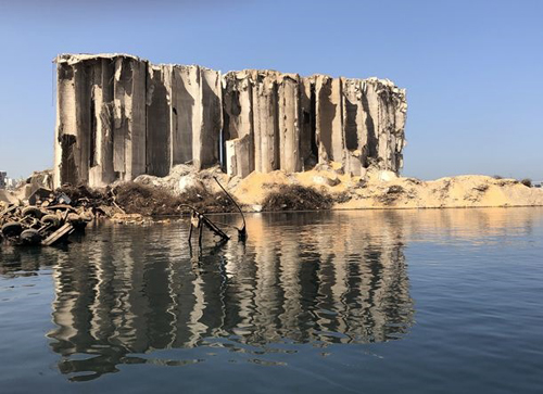
22 April 2021–Days after the 4 August 2020 massive explosion at the port of Beirut in Lebanon, researchers were on the ground mapping the impacts of the explosion in the port and surrounding city.
The goal was to document and preserve data on structural and façade damage before rebuilding, said University of California, Los Angeles civil and environmental engineer Jonathan Stewart, who spoke about the effort at the Seismological Society of America (SSA)’s 2021 Annual Meeting.
The effort also provided an opportunity to compare NASA Jet Propulsion Laboratory satellite surveys of the blast effects with data collected from the ground surveys. Stewart and his colleagues concluded that satellite-based Damage Proxy Maps were effective at identifying severely damaged buildings and undamaged buildings, but were less effective for assessing intermediate levels of structural or façade damage.
“The main take away is that the Damage Proxy Maps can definitely distinguish severe damage from lack of damage” for both structural and façade assessments, Stewart said, “but they are not as good at finer tuning.”
“If what you’re interested in is a fairly detailed picture of what has happened, it’s not able to replace a person who actually knows what they’re doing looking at the structure, particularly from the inside,” he added.
The reconnaissance of the Beirut blast was organized through the National Science Foundation-sponsored Geotechnical Extreme Events Reconnaissance Association (GEER). In addition to Stewart and his colleagues at the American University of Beirut, the team included members from the University of Illinois and the University of Calabria in Italy. The information analyzed by the GEER team can help engineers learn more about how to build safely against similarly destructive events, including earthquakes, in the future.
Their findings, detailed in a GEER report, also “make some recommendations about how you can optimize human resources when doing these inspections,” Stewart said.
On that August day, a fire at the port detonated an estimated 2.75 kilotons TNT equivalent of ammonium nitrate and fuel, an event about the size of a magnitude 3.3 earthquake. Within days, engineers at the American University of Beirut “had set up a hotline where people could call in who were concerned with the stability of damaged structures,” Stewart said.
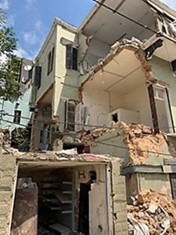
Professors and students made visits to inspect and assess the stability of these structures and others, but the in-person visits were scaled back in September due to COVID-19. After that, the researchers depended on street view surveys, using GoPro 360-degree cameras mounted on cars driven around the city.
The damage was ranked using scales adapted from those used for post-earthquake events, said Stewart. For instance, structural damage was ranked on a scale that began with minor damage to non-load bearing elements up to the complete collapse of a structure. Façade damage was ranked using a scale that begins with cracked windows and extends to complete blowout of windows and doors.
The spatial patterns of damage from an explosion differ from those seen in an earthquake. Site conditions such as underlying soil matter much more when it comes to the structural impact of an earthquake, while explosion damage depends “on how much are you feeling that blast,” Stewart explained. “With an explosion, the damage decreases with distance and with the number of buildings between you and the blast that can deflect its effects.”
Stewart isn’t an expert in explosion seismology, but he has experience in assessing structural damage after earthquakes from his work in post-earthquake zones with GEER. He reached out to a colleague at the American University in Beirut after the disaster to offer his help in collecting observations that could be useful to future researchers and engineers.
“We felt that it was important to gather perishable data that we anticipate will be useful to people who study blast effects in an urban setting, and to learn something from this disaster to improve our resilience to future such disasters,” he said.