9 December 2020–The summer 2018 eruption of Kīlauea Volcano on the Island of Hawai’i was one of the most significant in the volcano’s history, collapsing a large portion of the summit caldera, erupting massively from its flank and triggering a magnitude 6.9 earthquake in the process. Through it all, scientists at the Hawaiian Volcano Observatory were installing new geophysical stations, processing data and making real-time reports to local authorities and neighborhoods.
In the journal Seismological Research Letters, U.S. Geological Survey geophysicist Brian Shiro and colleagues describe their unprecedented efforts to observe and analyze a volcano that was destroying instruments and severing data connections. The paper is part of the journal’s upcoming focus section on monitoring during crisis.
The researchers had been monitoring signs of imminent eruption before the 30 April 2018 collapse of the Pu‘u ‘Ō‘ō vent, which had been erupting continually since 1983. Within a few hours, an unexpected magma intrusion began migrating through the volcano’s East Rift Zone, and “we knew this would not be the next episode of the Pu‘u ‘Ō‘ō eruption,” said Shiro. “Within a day or so when the intrusion was approaching the populated area of Leilani Estates, we knew this could potentially be devastating.”
When the 2018 event was finished, lava had covered a 35-kilometer square area and 716 structures had been destroyed by the flow, displacing more than 2,500 people. Sulfur dioxide emissions rates were among the highest measured on the island and more than 60,000 earthquakes were recorded.
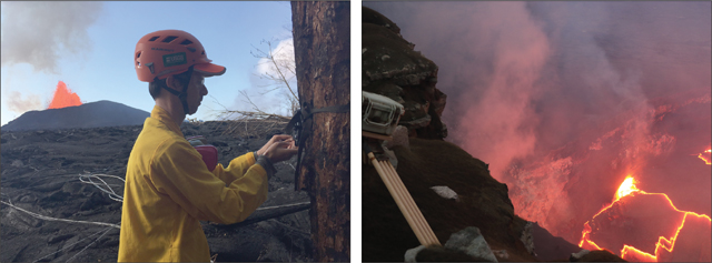
Right: Camera perched on the rim of Halema‘uma‘u crater monitors the summit lava lake prior to the eruption. | Carolyn Parcheta
Shiro and others at the observatory sprang into action to continue monitoring the volcano even as lava, fires, ashfall and collapsing cliffs destroyed geophysical monitoring stations. They also deployed new temporary stations to the sparsely instrumented lower East Rift Zone. The team was able to respond quickly by leveraging capacities that had been established earlier, they write.
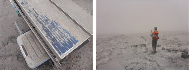
Since 2014, the observatory had been building portable solar power and electronic systems for monitoring stations that could be delivered by pickup truck and helicopter slings. They had also designed the island’s network structure so that data could be quickly rerouted in case of station or network relay failure. And only four months before the eruption, the observatory had rebuilt and migrated all its seismic data processing systems to live on virtual machines that could be backed up to cloud servers.
“To monitor a hazard, we need both the instruments in the field to collect the data and a way to get the data back to the scientists and decision makers to make use of it. Having a pre-assembled set of stations ready for rapid deployment can be a key capability to help monitor an emerging, changeable hazard,” Shiro explained.
A. Lerner
Right: An HVO scientist holds a portable spectrometer to make a sulfur dioxide emission rate measurement. | L. Clor
In the wake of multiple earthquakes during May 2018, the researchers had to permanently evacuate their facilities at the volcano’s summit, setting up two temporary facilities in Hilo. “This is where the virtual machines or VMs came in handy for HVO,” said Shiro. “Since we had to evacuate our facility, threatening our data center, we were able to easily move those VMs elsewhere and assure no downtime with data processing.”
Shiro recalls discussing the dangers with the scientist in charge at HVO in mid-May 2018. The flank eruption was devastating, he said, but he thought the bigger problems might come at the summit. “Within a few days from that conversation she made the call to abandon the facility as the seismic shaking only continued to worsen,” he said. “It was the right call given the emerging evidence of structural damage that had begun to show and worsened over the next three months.”
The scientists divided into three main teams to collect data in the field, to analyze and interpret the data and to communicate and coordinate with government officials and communities. The observatory’s full-time staff of 29 grew to 90, with people joining from other USGS offices, universities and volunteers.
“In a sense, the staff members of all five USGS volcano observatories acted as one for the Kīlauea response, providing valuable cross-training for everyone and helping us all get to know one another so that we will be even better prepared for the next crisis,” Shiro said.